A wide range of spatial data has been analysed to present this overview of the GL11 4 Postcode sector. If you would like anything added, please contact us.
The GL11 4 postcode sector is within the county of Gloucestershire.
Did you know? According to the 2021 Census, the GL11 4 postcode sector is home to a bustling 6,532 residents!
Given that each sector allows for 400 unique postcode combinations. Letters C, I, K, M, O and V are not allowed in the last two letters of a postcode. With 182 postcodes already in use, this leaves 218 units available.
The largest settlements in the GL11 4 postal code are DURSLEY and Woodmancote.
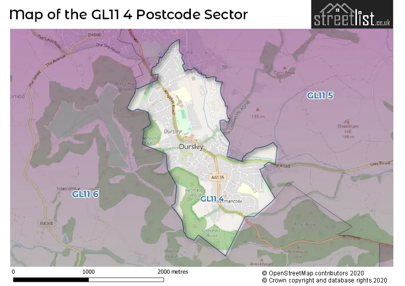
The GL11 4 Postcode shares a border with GL11 5 (Cam, Uley, DURSLEY) and GL11 6 (DURSLEY, North Nibley, Stinchcombe).
Map of the GL11 4 Postcode Sector
Explore the GL11 4 postcode sector by using our interactive map.
The sector is within the post town of DURSLEY.
GL11 4 is a postcode sector within the GL11 postcode district which is within the GL Gloucester postcode area.
The Royal Mail delivery office for the GL11 4 postal sector is the Dursley Delivery Office.
The area of the GL11 4 postcode sector is 1.00 square miles which is 2.58 square kilometres or 638.41 square acres.
Your support helps keep this site running!
If you enjoy using this website, consider buying me a coffee to help cover hosting costs.


| G | L | 1 | 1 | - | 4 | X | X |
| G | L | 1 | 1 | Space | 4 | Letter | Letter |
Official List of Streets
DURSLEY (99 Streets)
Woodmancote (6 Streets)
(3 Streets)
Unofficial Streets or Alternative Spellings
DURSLEY
ASHWORTH CLOSE CASTLE STREAM COURT FERNEY LOWER POOLE CLOSE THE BROADWAY YELLOW HUNDRED CLOSENorman Hill
BIRCH ROAD APRIL CLOSE BLACK WELLS BLACKBOYS BUDDING WAY CHAMPIONS COURT CHESTAL GANZELL LANE HADDRELL CLOSE KINGSHILL PARADE LISTER STREET SAINT GEORGES ROAD SHEARING CLOSE ST MARKS RISE WAREND HILLCam
DRAKE LANEWeather Forecast for GL11 4
Weather Forecast for Dursley
| Time Period | Icon | Description | Temperature | Rain Probability | Wind |
|---|---|---|---|---|---|
| 18:00 to 21:00 | Cloudy | 6.0°C (feels like 3.0°C) | 5.00% | S 7 mph | |
| 21:00 to 00:00 | Cloudy | 5.0°C (feels like 2.0°C) | 5.00% | S 9 mph |
| Time Period | Icon | Description | Temperature | Rain Probability | Wind |
|---|---|---|---|---|---|
| 00:00 to 03:00 | Overcast | 5.0°C (feels like 2.0°C) | 9.00% | S 9 mph | |
| 03:00 to 06:00 | Overcast | 5.0°C (feels like 3.0°C) | 11.00% | S 7 mph | |
| 06:00 to 09:00 | Overcast | 6.0°C (feels like 3.0°C) | 11.00% | S 7 mph | |
| 09:00 to 12:00 | Overcast | 7.0°C (feels like 4.0°C) | 13.00% | S 9 mph | |
| 12:00 to 15:00 | Cloudy | 8.0°C (feels like 6.0°C) | 7.00% | SW 11 mph | |
| 15:00 to 18:00 | Cloudy | 9.0°C (feels like 7.0°C) | 6.00% | SSW 9 mph | |
| 18:00 to 21:00 | Cloudy | 7.0°C (feels like 4.0°C) | 5.00% | S 11 mph | |
| 21:00 to 00:00 | Cloudy | 7.0°C (feels like 3.0°C) | 4.00% | SSW 13 mph |
| Time Period | Icon | Description | Temperature | Rain Probability | Wind |
|---|---|---|---|---|---|
| 00:00 to 03:00 | Partly cloudy (night) | 7.0°C (feels like 3.0°C) | 3.00% | SSW 13 mph | |
| 03:00 to 06:00 | Cloudy | 7.0°C (feels like 3.0°C) | 6.00% | SSW 13 mph | |
| 06:00 to 09:00 | Cloudy | 7.0°C (feels like 3.0°C) | 6.00% | SSW 16 mph | |
| 09:00 to 12:00 | Cloudy | 8.0°C (feels like 5.0°C) | 8.00% | SSW 16 mph | |
| 12:00 to 15:00 | Light rain | 10.0°C (feels like 7.0°C) | 56.00% | SSW 18 mph | |
| 15:00 to 18:00 | Heavy rain | 10.0°C (feels like 7.0°C) | 90.00% | SSW 16 mph | |
| 18:00 to 21:00 | Heavy rain | 8.0°C (feels like 5.0°C) | 77.00% | SW 11 mph | |
| 21:00 to 00:00 | Clear night | 6.0°C (feels like 3.0°C) | 3.00% | WSW 11 mph |
| Time Period | Icon | Description | Temperature | Rain Probability | Wind |
|---|---|---|---|---|---|
| 00:00 to 03:00 | Clear night | 5.0°C (feels like 2.0°C) | 1.00% | WSW 9 mph | |
| 03:00 to 06:00 | Clear night | 4.0°C (feels like 1.0°C) | 1.00% | WSW 7 mph | |
| 06:00 to 09:00 | Clear night | 2.0°C (feels like 0.0°C) | 1.00% | WSW 7 mph | |
| 09:00 to 12:00 | Cloudy | 4.0°C (feels like 1.0°C) | 4.00% | WSW 4 mph | |
| 12:00 to 15:00 | Cloudy | 7.0°C (feels like 6.0°C) | 4.00% | W 4 mph | |
| 15:00 to 18:00 | Cloudy | 8.0°C (feels like 6.0°C) | 4.00% | NW 4 mph | |
| 18:00 to 21:00 | Partly cloudy (night) | 4.0°C (feels like 2.0°C) | 1.00% | N 2 mph | |
| 21:00 to 00:00 | Clear night | 2.0°C (feels like 0.0°C) | 1.00% | N 2 mph |
| Time Period | Icon | Description | Temperature | Rain Probability | Wind |
|---|---|---|---|---|---|
| 00:00 to 03:00 | Clear night | 0.0°C (feels like -1.0°C) | 1.00% | ENE 2 mph | |
| 03:00 to 06:00 | Clear night | 0.0°C (feels like -2.0°C) | 1.00% | ENE 4 mph | |
| 06:00 to 09:00 | Clear night | -1.0°C (feels like -3.0°C) | 1.00% | ENE 4 mph | |
| 09:00 to 12:00 | Sunny day | 1.0°C (feels like -1.0°C) | 2.00% | NE 4 mph | |
| 12:00 to 15:00 | Sunny day | 6.0°C (feels like 4.0°C) | 1.00% | ENE 7 mph | |
| 15:00 to 18:00 | Sunny day | 7.0°C (feels like 5.0°C) | 1.00% | E 9 mph | |
| 18:00 to 21:00 | Clear night | 3.0°C (feels like 1.0°C) | 1.00% | ENE 7 mph | |
| 21:00 to 00:00 | Clear night | 2.0°C (feels like -1.0°C) | 1.00% | ENE 7 mph |
Schools and Places of Education Within the GL11 4 Postcode Sector
Dursley Church of England Primary Academy
Academy sponsor led
School Road, Dursley, Gloucestershire, GL11 4NZ
Head: Toni Holford-Wright
Ofsted Rating: Good
Inspection: 2019-01-29 (2196 days ago)
Website: Visit Dursley Church of England Primary Academy Website
Phone: 01453542304
Number of Pupils: 273
Rednock School
Foundation school
Kingshill Road, Dursley, Gloucestershire, GL11 4BY
Head: Mr Mike Stratford
Ofsted Rating: Good
Inspection: 2023-11-22 (438 days ago)
Website: Visit Rednock School Website
Phone: 01453543618
Number of Pupils: 1251
House Prices in the GL11 4 Postcode Sector
| Type of Property | 2018 Average | 2018 Sales | 2017 Average | 2017 Sales | 2016 Average | 2016 Sales | 2015 Average | 2015 Sales |
|---|---|---|---|---|---|---|---|---|
| Detached | £357,102 | 37 | £323,534 | 24 | £310,902 | 22 | £285,500 | 20 |
| Semi-Detached | £252,127 | 52 | £219,429 | 33 | £200,189 | 49 | £193,834 | 40 |
| Terraced | £193,224 | 36 | £189,828 | 39 | £184,651 | 37 | £163,325 | 26 |
| Flats | £117,248 | 24 | £115,133 | 15 | £98,719 | 18 | £100,552 | 21 |
Important Postcodes GL11 4 in the Postcode Sector
GL11 4BA is the postcode for Gloucestershire Care Services NHS Trust, Lister Road, and Gloucestershire Health and Care NHS Foundation Trust, Vale Community Hospital, Lister Road
GL11 4BP is the postcode for The Kings Head Inn, 53-75 Parsonage Street
GL11 4BS is the postcode for The Pulse Dursley, Castle Street
GL11 4BY is the postcode for SPORTS HALL, Rednock School, Rednock Drive, and Rednock School, Rednock Drive
GL11 4BZ is the postcode for Dursley Fire Station, Kingshill Lane
GL11 4JH is the postcode for Dursley Library, May Lane
GL11 4NZ is the postcode for Dursley C of E Primary School, School Road, and TREETOPS CHILDRENS CENTRE, Dursley C of E Primary School, School Road
| The GL11 4 Sector is within these Local Authorities |
|
|---|---|
| The GL11 4 Sector is within these Counties |
|
| The GL11 4 Sector is within these Water Company Areas |
|