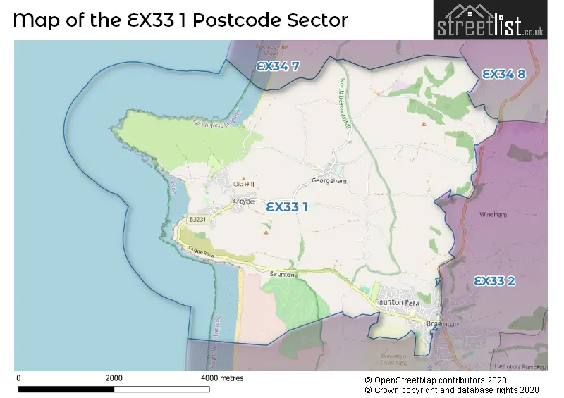
A wide range of spatial data has been analysed to present this overview of the EX33 1 Postcode sector. If you would like anything added, please contact us.
The EX33 1 postcode sector is within the county of Devon.
Did you know? According to the 2021 Census, the EX33 1 postcode sector is home to a bustling 5,089 residents!
Given that each sector allows for 400 unique postcode combinations. Letters C, I, K, M, O and V are not allowed in the last two letters of a postcode. With 199 postcodes already in use, this leaves 201 units available.
The largest settlement in the EX33 1 postal code is BRAUNTON followed by Croyde, and Georgeham.
The EX33 1 Postcode shares a border with EX33 2 (BRAUNTON, Wrafton, Knowle), EX34 7 (WOOLACOMBE, Mortehoe) and EX34 8 (ILFRACOMBE, West Down, Lee).
Map of the EX33 1 Postcode Sector
Explore the EX33 1 postcode sector by using our interactive map.
The sector is within the post town of BRAUNTON.
EX33 1 is a postcode sector within the EX33 postcode district which is within the EX Exeter postcode area.
The Royal Mail delivery office for the EX33 1 postal sector is the Barnstaple Delivery Office.
The area of the EX33 1 postcode sector is 11.63 square miles which is 30.11 square kilometres or 7,440.24 square acres.
Waterways within the EX33 1 postcode sector include the River Caen.
Your support helps keep this site running!
If you enjoy using this website, consider buying me a coffee to help cover hosting costs.


| E | X | 3 | 3 | - | 1 | X | X |
| E | X | 3 | 3 | Space | 1 | Letter | Letter |
Official List of Streets
BRAUNTON (78 Streets)
Croyde (34 Streets)
(7 Streets)
Georgeham (8 Streets)
Unofficial Streets or Alternative Spellings
BRAUNTON
BROADGATE CLOSE CAEN FIELD SHOPPING CENTRE CHURCH STREET ILFRACOMBE ROAD STATION ROAD ADWELL LANE BARTON CLOSE BARTON CLOSE LANE BLIND ACRES LANE BOTTOMS LANE BRACKEN VIEW BROAD LANE BROADWAY LANE BROOMHILL LANE BUCKLAND CROSS BUCKLAND ROAD BURROWS CLOSE LANE BUTTS BRIDGE CASCADES WAY CASTLE LANE CASTLE LANE TRACK CHALONERS ROAD CHURCH ROAD CROSS FARM CROSS TREE CROWBOROUGH ROAD CROYDE ROAD DOWN LANE EASTERN DOWN LANE FIELD LANE FROGSTREET HILL GEORGEHAM ROAD HANNABURROW LANE HOLE CLEAVE ROAD HOLE LANE INCLEDON HILL JENKERS HILL KENNEL LANE LIME TREE LONG LANE LOWER CLEVE MAINS DOWN LANE MARINE DRIVE MEADOW LANE MILL LANE NETHERCOTT ROAD NETHERHAMS HILL NEWBERRY ROAD NORTH BUCKLAND HILL NORTHFIELD ROAD NT PATH ORA LANE ORCHARDON LANE PATHDOWN LANE SINGS LANE STENTAWAY LANE STONY LANE TRACK TARKA WAY THE DUNES THE WARREN VENTION LANE WEST HILL LANE WEST LANE WILLINGCOTT HILL WILLOWAYS CLOSE WOOD LANEVelator
VELATOR WAYWeather Forecast for EX33 1
Weather Forecast for Putsborough Sands (Beach)
Schools and Places of Education Within the EX33 1 Postcode Sector
Caen Community Primary School
Foundation school
Caen Street, Braunton, Devon, EX33 1AD
Head: Mr Sam Page
Ofsted Rating: Good
Inspection: 2023-03-14 (692 days ago)
Website: Visit Caen Community Primary School Website
Phone: 01271812786
Number of Pupils: 412
Kingsacre Primary School
Foundation school
Greenacre, Braunton, Devon, EX33 1BQ
Head: Mrs Claire Cole
Ofsted Rating: Good
Inspection: 2021-10-14 (1208 days ago)
Website: Visit Kingsacre Primary School Website
Phone: 01271815485
Number of Pupils: 200

House Prices in the EX33 1 Postcode Sector
| Type of Property | 2018 Average | 2018 Sales | 2017 Average | 2017 Sales | 2016 Average | 2016 Sales | 2015 Average | 2015 Sales |
|---|---|---|---|---|---|---|---|---|
| Detached | £443,640 | 56 | £436,227 | 70 | £449,939 | 42 | £393,853 | 78 |
| Semi-Detached | £260,492 | 16 | £293,728 | 27 | £293,831 | 24 | £341,324 | 23 |
| Terraced | £265,176 | 17 | £214,275 | 20 | £241,303 | 30 | £253,859 | 27 |
| Flats | £257,136 | 11 | £185,900 | 10 | £232,962 | 13 | £267,132 | 11 |
Important Postcodes EX33 1 in the Postcode Sector
EX33 1AD is the postcode for Braunton Cp School, Caen Street, and GYMNASIUM / HALL, Braunton Cp School, Caen Street
EX33 1BQ is the postcode for Kingsacre Community Primary School, Greenacre, and Kingsacre Primary School, Greenacre
EX33 1JT is the postcode for Georgeham C of E (V C) School, Georgeham
EX33 1LR is the postcode for Caen Medical Centre, Caen Street, and Lloyds Pharmacy, Caen Medical Centre
| The EX33 1 Sector is within these Local Authorities |
|
|---|---|
| The EX33 1 Sector is within these Counties |
|
| The EX33 1 Sector is within these Water Company Areas |
|