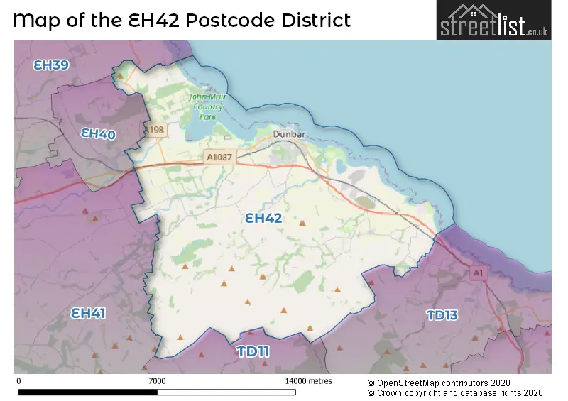
Map of the EH42 Postcode District
Explore the postcode district by using our interactive map.
Circles represent recorded crime; the larger the circle, the higher the crime rates.
Your support helps keep this site running!
If you enjoy using this website, consider buying me a coffee to help cover hosting costs.
Where is the EH42 District?
To give you an idea where the district is located we have created the following table showing nearby towns.
Nearest Towns to EH42
| Town | Distance (miles) | Direction |
|---|---|---|
| East Linton | 4.89 | WNW |
| Haddington | 9.46 | W |
| North Berwick | 9.62 | NW |
| Duns | 14.81 | SSE |
| Cockenzie and Port Seton | 16.02 | W |
| Tranent | 16.10 | W |
| Prestonpans | 17.22 | W |
| Eyemouth | 18.57 | ESE |
| Lauder | 18.57 | SSW |
| Pittenweem | 18.92 | NNW |
| Anstruther | 19.22 | NNW |
| Musselburgh | 19.79 | W |
| Crail | 20.94 | N |
| Dalkeith | 21.58 | WSW |
| Bonnyrigg | 22.82 | WSW |
| Leven | 23.98 | NW |
| Buckhaven | 24.00 | NW |
| Coldstream | 24.18 | SSE |
| Methil | 24.24 | NW |
The post town for this district is DUNBAR.
Postcode Information for District EH42 (Total Geographical Postcodes: 359)
| Location | Post Town | Sector | Number of Postcodes |
|---|---|---|---|
| DUNBAR | DUNBAR | EH42 1 | 291 |
| West Barns | DUNBAR | EH42 1 | 23 |
| Belhaven | DUNBAR | EH42 1 | 22 |
| Innerwick | DUNBAR | EH42 1 | 8 |
| Spott | DUNBAR | EH42 1 | 6 |
| Whitekirk | DUNBAR | EH42 1 | 4 |
| Tyninghame | DUNBAR | EH42 1 | 3 |
| Stenton | DUNBAR | EH42 1 | 2 |
The EH42 postcode district is primarily represented by the settlement of Dunbar in East Lothian, Scotland. Other significant settlements in this district include Belhaven, Innerwick, Spott, Stenton, Tyninghame, West Barns, and Whitekirk. The most significant post town in this district is Dunbar.
When it comes to local government, postal geography often disregards political borders. However, this district intersects the following councils: the district mostly encompasses the East Lothian area with a total of 352 postal codes.
The largest settlement in the EH42 postal code is DUNBAR followed by West Barns, and Belhaven.
The postcode area has a boundary with The North Sea.
The EH42 Postcode shares a border with TD11 (DUNS, Chirnside, Grantshouse), EH40 (EAST LINTON), EH41 (HADDINGTON, Gifford), EH39 (NORTH BERWICK, Dirleton, East Fortune) and TD13 (COCKBURNSPATH, Oldhamstocks, Cove).
Postcode Sectors


Stations in the Sector
Dunbar
CRS Code: DUN
Operator: SR
Line: East Coast Main Line
Company: ScotRail
Accessable Motorway Junctions
M8 J1
Average Driving Time from within the district: 34.67
Average Driving Distance: 34.07
Number of Postcodes that can access the Motorway Junction: 178
M9 J1
Average Driving Time from within the district: 40.18
Average Driving Distance: 35.88
Number of Postcodes that can access the Motorway Junction: 10
M90 J1B
Average Driving Time from within the district: 46.96
Average Driving Distance: 44.88
Number of Postcodes that can access the Motorway Junction: 10
M90 J1
Average Driving Time from within the district: 48.53
Average Driving Distance: 46.47
Number of Postcodes that can access the Motorway Junction: 23
M90 J2
Average Driving Time from within the district: 49.55
Average Driving Distance: 48.43
Number of Postcodes that can access the Motorway Junction: 5
M90 J3
Average Driving Time from within the district: 51.54
Average Driving Distance: 50.58
Number of Postcodes that can access the Motorway Junction: 8
M90 J2A
Average Driving Time from within the district: 51.91
Average Driving Distance: 50.40
Number of Postcodes that can access the Motorway Junction: 14
Weather Forecast for Belhaven Bay
| Postal Sector | Delivery Office |
|---|---|
| EH42 1 | Dunbar Delivery Office (eh) |
| E | H | 4 | 2 | - | X | X | X |
| E | H | 4 | 2 | Space | Numeric | Letter | Letter |
Street List for the EH42 District
Current Monthly Rental Prices
| # Bedrooms | Min Price | Max Price | Avg Price |
|---|---|---|---|
| £625 | £625 | £625 |
Current House Prices
| # Bedrooms | Min Price | Max Price | Avg Price |
|---|---|---|---|
| 2 | £65,000 | £325,000 | £194,083 |
| 3 | £359,000 | £360,000 | £359,333 |
| 4 | £340,000 | £735,000 | £485,000 |
| 5 | £535,000 | £925,000 | £599,286 |
| 6 | £945,000 | £945,000 | £945,000 |
Estate Agents
| Logo | Name | Brand Name | Address | Contact Number |
|---|---|---|---|---|
 | Newton Manor | Robertson Homes | Queens Road, Off A1087, Dunbar, EH42 1ZX | 01368 653213 |
 | North Berwick | Simpson & Marwick | 88 High Street, North Berwick, EH39 4HE | 01620 678806 |
 | Edinburgh | Knight Frank | 80 Queen Street, Edinburgh, EH2 4NF | 0131 381 0405 |
 | Edinburgh Country | Savills | Wemyss House 8 Wemyss Place Edinburgh EH3 6DH | 0131 381 2387 |
 | East Lothian | Gilson Gray LLP | 29 Rutland Square Edinburgh EH39 4AG | 01620 672926 |
