A wide range of spatial data has been analysed to present this overview of the EH32 0 Postcode sector. If you would like anything added, please contact us.
Given that each sector allows for 400 unique postcode combinations. Letters C, I, K, M, O and V are not allowed in the last two letters of a postcode. With 256 postcodes already in use, this leaves 144 units available.
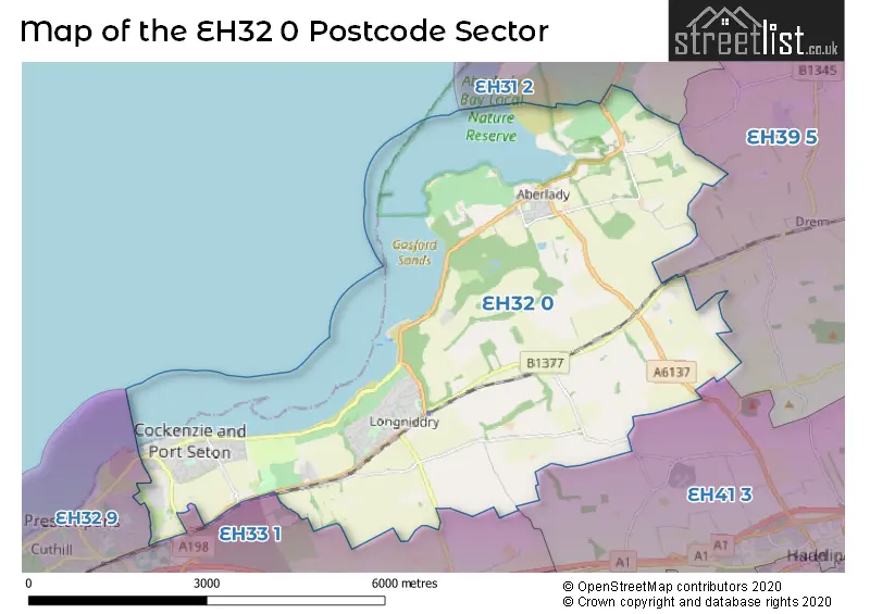
The largest settlement in the EH32 0 postal code is Port Seton followed by LONGNIDDRY, and Aberlady.
The EH32 0 Postcode shares a border with EH39 5 (NORTH BERWICK, Dirleton, East Fortune), EH31 2 (GULLANE), EH32 9 (PRESTONPANS, Blindwells), EH33 1 (TRANENT, Macmerry, Gladsmuir) and EH41 3 (HADDINGTON).
Map of the EH32 0 Postcode Sector
Explore the EH32 0 postcode sector by using our interactive map.
The sector is within the post town of PRESTONPANS.
EH32 0 is a postcode sector within the EH32 postcode district which is within the EH Edinburgh postcode area.
The Royal Mail delivery office for the EH32 0 postal sector is the Prestonpans Delivery Office.
The area of the EH32 0 postcode sector is 13.19 square miles which is 34.17 square kilometres or 8,443.04 square acres.
Your support helps keep this site running!
If you enjoy using this website, consider buying me a coffee to help cover hosting costs.


| E | H | 3 | 2 | - | 0 | X | X |
| E | H | 3 | 2 | Space | 0 | Letter | Letter |
Official List of Streets
Port Seton (51 Streets)
LONGNIDDRY (62 Streets)
Cockenzie (28 Streets)
Aberlady (29 Streets)
PRESTONPANS (1 Streets)
Unofficial Streets or Alternative Spellings
PRESTONPANS
ATHOLL VIEW JACOBITE WAY MCLACHLAN GARDENS PRESTON CRESCENT STRUAN WYNDWeather Forecast for EH32 0
Weather Forecast for Longniddry (Beach)
| The EH32 0 Sector is within these Local Authorities | |
|---|---|
| The EH32 0 Sector is within these Counties | |
| The EH32 0 Sector is within these Water Company Areas |