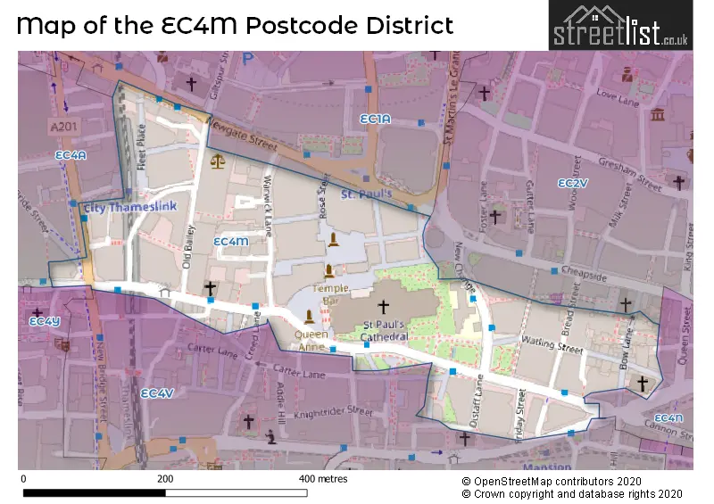
Map of the EC4M Postcode District
Explore the postcode district by using our interactive map.
Circles represent recorded crime; the larger the circle, the higher the crime rates.
Your support helps keep this site running!
If you enjoy using this website, consider buying me a coffee to help cover hosting costs.
Where is the EC4M District?
To give you an idea where the district is located we have created the following table showing nearby towns.
Nearest Towns to EC4M
| Town | Distance (miles) | Direction |
|---|---|---|
| City of London | 0.30 | E |
| City of Westminster | 1.47 | SW |
| Chigwell | 10.49 | NE |
| Loughton | 12.14 | NE |
| Waltham Cross | 12.21 | NNE |
| Borehamwood | 12.43 | NW |
| Waltham Abbey | 12.91 | NNE |
| Ewell | 13.10 | SSW |
| Potters Bar | 13.15 | NNW |
| Cheshunt | 13.26 | N |
| Banstead | 14.05 | SSW |
| Warlingham | 14.24 | S |
| Swanley | 14.25 | SE |
| Epsom | 14.46 | SSW |
| Bushey | 14.56 | NW |
| Radlett | 15.06 | NW |
| Esher | 15.25 | SW |
| Sunbury-on-Thames | 15.28 | WSW |
| Dartford | 15.47 | ESE |
| Epping | 15.61 | NE |
The post town for this district is LONDON.
Postcode Information for District EC4M (Total Geographical Postcodes: 97)
| Location | Post Town | Sector | Number of Postcodes |
|---|---|---|---|
| City of London | LONDON | EC4M 7 | 53 |
| City of London | LONDON | EC4M 9 | 26 |
| City of London | LONDON | EC4M 8 | 11 |
| City of London | LONDON | EC4M 5 | 3 |
| City of London | LONDON | EC4M 6 | 2 |
| Islington | LONDON | EC4M 7 | 2 |
Retail and Shopping in EC4M
Street
Town
Locality
Number of Shops
Central Postcode
View on Google Maps
BOW LANE
LONDON
23
EC4M 9DT
View on Google Maps
LUDGATE HILL
LONDON
22
EC4M 7AE
View on Google Maps
NEW CHANGE PASSAGE
LONDON
14
EC4M 9AG
View on Google Maps
WATLING STREET
LONDON
14
EC4M 9BJ
View on Google Maps
LOWER NEW CHANGE PASSAGE
LONDON
12
EC4M 9AH
View on Google Maps
PATERNOSTER SQUARE
LONDON
12
EC4M 7DX
View on Google Maps
ST PAULS CHURCHYARD
LONDON
9
EC4M 8AE
View on Google Maps
LUDGATE CIRCUS
LONDON
8
EC4M 7LW
View on Google Maps
PATERNOSTER ROW
LONDON
8
EC4M 7EJ
View on Google Maps
| Street | Town | Locality | Number of Shops | Central Postcode | View on Google Maps |
|---|---|---|---|---|---|
| BOW LANE | LONDON | 23 | EC4M 9DT | View on Google Maps | |
| LUDGATE HILL | LONDON | 22 | EC4M 7AE | View on Google Maps | |
| NEW CHANGE PASSAGE | LONDON | 14 | EC4M 9AG | View on Google Maps | |
| WATLING STREET | LONDON | 14 | EC4M 9BJ | View on Google Maps | |
| LOWER NEW CHANGE PASSAGE | LONDON | 12 | EC4M 9AH | View on Google Maps | |
| PATERNOSTER SQUARE | LONDON | 12 | EC4M 7DX | View on Google Maps | |
| ST PAULS CHURCHYARD | LONDON | 9 | EC4M 8AE | View on Google Maps | |
| LUDGATE CIRCUS | LONDON | 8 | EC4M 7LW | View on Google Maps | |
| PATERNOSTER ROW | LONDON | 8 | EC4M 7EJ | View on Google Maps |
The EC4M postcode district primarily consists of the City of London, which is located within the City and County of the City of London. Other significant settlements in this district include Islington, which is part of Greater London. The main post town for this district is London, which is in the County of the City of London in England.
When it comes to local government, postal geography often disregards political borders. However, this district intersects the following councils: the district mostly encompasses the City and County of the City of London area with a total of 91 postal codes.
The EC4M postal code covers the settlement of LONDON.
The EC4M Postcode shares a border with EC4N (LONDON), EC4V (LONDON), EC4Y (LONDON, MIDDLE TEMPLE, INNER TEMPLE) and EC1A (LONDON, ISLINGTON).


Dentists in the EC4M District
No dentists found in this district.
Doctors in the EC4M District
No Doctors found in this district.
Chemists in the EC4M District
| # | Name | Address | Type | Contact |
|---|---|---|---|---|
| 1 | Boots | 21 NEW CHANGE PASSAGE , LONDON , GREATER LONDON , EC4M 9AG | PHARMACY |
Opticians in the EC4M District
| # | Name | Address | Type | Contact |
|---|---|---|---|---|
| 1 | BOOTS OPTICIANS (CHEAPSIDE, LONDON) | UNIT 7 , PATERNOSTER SQUARE , LONDON , GREATER LONDON , EC4M 7DX | OPTICAL SITE |
Stations in the Sector
City Thameslink
CRS Code: CTK
Operator: TL
Line: Thameslink
Company: Govia Thameslink Railway (Thameslink)
Accessable Motorway Junctions
M1 J1
Average Driving Time from within the district: 20.69
Average Driving Distance: 8.26
Number of Postcodes that can access the Motorway Junction: 95
M4 J2
Average Driving Time from within the district: 21.20
Average Driving Distance: 9.31
Number of Postcodes that can access the Motorway Junction: 95
Weather Forecast for City Of London Youth Hostel
| Postal Sector | Delivery Office |
|---|
| E | C | 4 | M | - | X | X | X |
| E | C | 4 | M | Space | Numeric | Letter | Letter |
Tourist Attractions
We found 1 visitor attractions.
| St Paul's Cathedral |
|---|
| Places of Worship |
| Place of Worship (still in use) |
| View St Paul's Cathedral on Google Maps |
Street List for the EC4M District
Current Monthly Rental Prices
| # Bedrooms | Min Price | Max Price | Avg Price |
|---|---|---|---|
| £3,467 | £3,467 | £3,467 | |
| 1 | £2,350 | £4,983 | £3,913 |
| 3 | £3,750 | £3,750 | £3,750 |
Current House Prices
| # Bedrooms | Min Price | Max Price | Avg Price |
|---|---|---|---|
| £295,000 | £525,000 | £410,000 | |
| 1 | £725,000 | £725,000 | £725,000 |
| 2 | £725,000 | £1,500,000 | £989,000 |
Estate Agents
| Logo | Name | Brand Name | Address | Contact Number |
|---|---|---|---|---|
 | London | Scott City Residential | 122 Newgate Street London EC1A 7AA | 020 3870 7036 |
 | Tower Bridge Lettings | Chestertons Estate Agents | 220 Tower Bridge Road, Tower Bridge, London, SE1 2UP | 020 3826 8110 |
 | City | Hamptons Lettings | Aldermary House, 15 Queen Street, London, EC4N 1TX | 020 3870 5615 |
 | London | JC Living | JC Living, 6 Union street, London, SE1 1SZ | 020 3834 7878 |
 | London Bridge | Hastings International | 42 Borough High Street, London, SE1 1XW | 020 3873 5885 |
Yearly House Price Averages for the District
| Type of Property | 2018 Average | 2018 Sales | 2017 Average | 2017 Sales | 2016 Average | 2016 Sales | 2015 Average | 2015 Sales |
|---|---|---|---|---|---|---|---|---|
| Detached | £0 | 0 | £0 | 0 | £0 | 0 | £0 | 0 |
| Semi-Detached | £0 | 0 | £0 | 0 | £0 | 0 | £0 | 0 |
| Terraced | £0 | 0 | £0 | 0 | £0 | 0 | £0 | 0 |
| Flats | £590,000 | 1 | £0 | 0 | £0 | 0 | £798,036 | 7 |
