A wide range of spatial data has been analysed to present this overview of the E16 4 Postcode sector. If you would like anything added, please contact us.
The E16 4 postcode sector is within the county of Greater London.
Did you know? According to the 2021 Census, the E16 4 postcode sector is home to a bustling 10,255 residents!
Given that each sector allows for 400 unique postcode combinations. Letters C, I, K, M, O and V are not allowed in the last two letters of a postcode. With 150 postcodes already in use, this leaves 250 units available.
The largest settlements in the E16 4 postal code are CANNING TOWN and PLAISTOW .
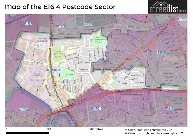
The E16 4 Postcode shares a border with E13 0 (PLAISTOW , UPTON PARK , STRATFORD ), E3 3 (LONDON ), E13 8 (PLAISTOW ), E14 0 (LONDON ), E15 3 (STRATFORD ), E16 1 (CANNING TOWN , SILVERTOWN ) and E16 3 (WEST BECKTON , CANNING TOWN ).
Map of the E16 4 Postcode Sector
Explore the E16 4 postcode sector by using our interactive map.
The sector is within the post town of LONDON.
E16 4 is a postcode sector within the E16 postcode district which is within the E East London postcode area.
The Royal Mail delivery office for the E16 4 postal sector is the Victoria Docks Sdelivery Office.
The area of the E16 4 postcode sector is 0.49 square miles which is 1.28 square kilometres or 316.73 square acres.
Your support helps keep this site running!
If you enjoy using this website, consider buying me a coffee to help cover hosting costs.


| E | 1 | 6 | - | 4 | X | X |
| E | 1 | 6 | Space | 4 | Letter | Letter |
Official List of Streets
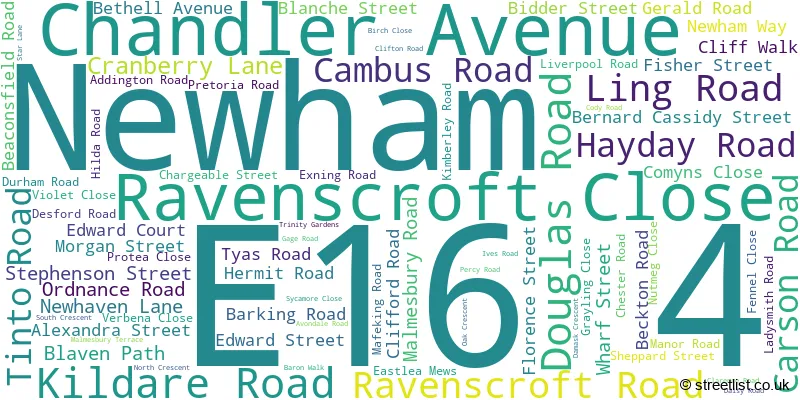
Newham (77 Streets)
Unofficial Streets or Alternative Spellings
Newham
AVENONS ROAD CHARGEABLE LANE COLUMBIA ROAD EGHAM ROAD FREEMASONS ROAD GRANGE ROAD INGAL ROAD JUTLAND ROAD MAYFIELD ROAD NEW BARN STREET OHIO ROAD SILVERTOWN WAY TWELVETREES CRESCENT ASHMEAD BUSINESS CENTRE BIDDER STREET (NORTH) CANNING TOWN BUSINESS PARK CRESCENT COURT BUSINESS CENTRE DATAPOINT BUSINESS CENTRE EUROPA TRADE PARK FORWARD BUSINESS CENTRE GEMINI BUSINESS CENTRE MUSKELL INDUSTRIAL PLACE PROJECT PARKTower Hamlets
EAST INDIA DOCK ROADWeather Forecast for E16 4
Weather Forecast for Londonolympic Park South
| Time Period | Icon | Description | Temperature | Rain Probability | Wind |
|---|---|---|---|---|---|
| 21:00 to 00:00 | Overcast | 6.0°C (feels like 5.0°C) | 9.00% | ESE 4 mph |
| Time Period | Icon | Description | Temperature | Rain Probability | Wind |
|---|---|---|---|---|---|
| 00:00 to 03:00 | Overcast | 5.0°C (feels like 4.0°C) | 9.00% | ESE 4 mph | |
| 03:00 to 06:00 | Overcast | 5.0°C (feels like 4.0°C) | 10.00% | SE 4 mph | |
| 06:00 to 09:00 | Overcast | 5.0°C (feels like 3.0°C) | 10.00% | SE 4 mph | |
| 09:00 to 12:00 | Overcast | 5.0°C (feels like 3.0°C) | 9.00% | SE 4 mph | |
| 12:00 to 15:00 | Overcast | 7.0°C (feels like 5.0°C) | 8.00% | SSE 7 mph | |
| 15:00 to 18:00 | Cloudy | 7.0°C (feels like 5.0°C) | 8.00% | S 7 mph | |
| 18:00 to 21:00 | Partly cloudy (night) | 6.0°C (feels like 3.0°C) | 2.00% | SSE 7 mph | |
| 21:00 to 00:00 | Partly cloudy (night) | 4.0°C (feels like 2.0°C) | 2.00% | SSE 7 mph |
| Time Period | Icon | Description | Temperature | Rain Probability | Wind |
|---|---|---|---|---|---|
| 00:00 to 03:00 | Clear night | 3.0°C (feels like 1.0°C) | 1.00% | SE 7 mph | |
| 03:00 to 06:00 | Clear night | 2.0°C (feels like 0.0°C) | 1.00% | SE 4 mph | |
| 06:00 to 09:00 | Clear night | 1.0°C (feels like -1.0°C) | 2.00% | SE 4 mph | |
| 09:00 to 12:00 | Sunny day | 3.0°C (feels like 0.0°C) | 1.00% | SE 4 mph | |
| 12:00 to 15:00 | Sunny day | 6.0°C (feels like 4.0°C) | 3.00% | SSE 4 mph | |
| 15:00 to 18:00 | Sunny day | 7.0°C (feels like 6.0°C) | 3.00% | S 4 mph | |
| 18:00 to 21:00 | Clear night | 5.0°C (feels like 4.0°C) | 1.00% | S 4 mph | |
| 21:00 to 00:00 | Clear night | 3.0°C (feels like 2.0°C) | 2.00% | S 4 mph |
| Time Period | Icon | Description | Temperature | Rain Probability | Wind |
|---|---|---|---|---|---|
| 00:00 to 03:00 | Clear night | 2.0°C (feels like 1.0°C) | 2.00% | SSW 4 mph | |
| 03:00 to 06:00 | Clear night | 2.0°C (feels like 0.0°C) | 3.00% | SSW 4 mph | |
| 06:00 to 09:00 | Cloudy | 2.0°C (feels like 0.0°C) | 6.00% | SSW 4 mph | |
| 09:00 to 12:00 | Mist | 3.0°C (feels like 1.0°C) | 14.00% | SSW 4 mph | |
| 12:00 to 15:00 | Partly cloudy (day) | 6.0°C (feels like 4.0°C) | 2.00% | SSW 7 mph | |
| 15:00 to 18:00 | Partly cloudy (day) | 8.0°C (feels like 6.0°C) | 2.00% | SSW 7 mph | |
| 18:00 to 21:00 | Partly cloudy (night) | 6.0°C (feels like 4.0°C) | 2.00% | S 7 mph | |
| 21:00 to 00:00 | Partly cloudy (night) | 5.0°C (feels like 3.0°C) | 3.00% | SSW 7 mph |
| Time Period | Icon | Description | Temperature | Rain Probability | Wind |
|---|---|---|---|---|---|
| 00:00 to 03:00 | Partly cloudy (night) | 5.0°C (feels like 3.0°C) | 3.00% | SSW 7 mph | |
| 03:00 to 06:00 | Partly cloudy (night) | 5.0°C (feels like 3.0°C) | 5.00% | SSW 9 mph | |
| 06:00 to 09:00 | Partly cloudy (night) | 6.0°C (feels like 3.0°C) | 5.00% | SSW 9 mph | |
| 09:00 to 12:00 | Cloudy | 7.0°C (feels like 4.0°C) | 11.00% | SSW 9 mph | |
| 12:00 to 15:00 | Partly cloudy (day) | 9.0°C (feels like 7.0°C) | 11.00% | SSW 11 mph | |
| 15:00 to 18:00 | Cloudy | 10.0°C (feels like 8.0°C) | 15.00% | SSW 9 mph | |
| 18:00 to 21:00 | Light rain | 9.0°C (feels like 7.0°C) | 46.00% | SW 9 mph | |
| 21:00 to 00:00 | Partly cloudy (night) | 8.0°C (feels like 6.0°C) | 13.00% | SW 7 mph |
Schools and Places of Education Within the E16 4 Postcode Sector
Eastlea Community School
Academy sponsor led
Pretoria Road, London, , E16 4NP
Head: Ms Sarah Morgan
Ofsted Rating: Requires improvement
Inspection: 2023-04-20 (652 days ago)
Website: Visit Eastlea Community School Website
Phone: 02075400400
Number of Pupils: 885
Ravenscroft Primary School
Academy converter
Carson Road, London, , E16 4BD
Head: Mr Simon Bond
Ofsted Rating: Good
Inspection: 2019-11-20 (1899 days ago)
Website: Visit Ravenscroft Primary School Website
Phone: 02074762454
Number of Pupils: 556
Star Primary School
Community school
Star Lane, London, , E16 4NH
Head: Ms Lisle Von Buchenroder
Ofsted Rating: Good
Inspection: 2022-10-19 (835 days ago)
Website: Visit Star Primary School Website
Phone: 02074765336
Number of Pupils: 642

House Prices in the E16 4 Postcode Sector
| Type of Property | 2018 Average | 2018 Sales | 2017 Average | 2017 Sales | 2016 Average | 2016 Sales | 2015 Average | 2015 Sales |
|---|---|---|---|---|---|---|---|---|
| Detached | £0 | 0 | £0 | 0 | £0 | 0 | £0 | 0 |
| Semi-Detached | £402,500 | 2 | £411,250 | 2 | £356,000 | 5 | £338,000 | 2 |
| Terraced | £378,905 | 21 | £394,739 | 30 | £383,584 | 32 | £323,403 | 33 |
| Flats | £287,643 | 45 | £268,097 | 31 | £294,326 | 64 | £203,170 | 50 |
Important Postcodes E16 4 in the Postcode Sector
E16 4BD is the postcode for LONDON BOROUGH OF NEWHAM, Ravenscroft Primary School, Carson Road, and Ravenscroft Primary School, Carson Road
E16 4DD is the postcode for Rokeby School, Barking Road, and LONDON BOROUGH OF NEWHAM, Rokeby School, Barking Road
E16 4HQ is the postcode for London Borough of Newham, Canning Town Library, 103 Barking Road
E16 4HR is the postcode for Rawalpindi House, 81 Hermit Road
E16 4ND is the postcode for Eastlea Community School, Exning Road
E16 4NH is the postcode for Star Primary School, Hilda Road, LONDON BOROUGH OF NEWHAM, The annexe (kitchen) building, Star Primary School, LONDON BOROUGH OF NEWHAM, Star Primary School, Hilda Road, and STAR PRIMARY SCHOOL, STAR LANE, CANNING TOWN
E16 4NP is the postcode for GLASSHOUSE, Eastlea Community School, Pretoria Road, LONDON BOROUGH OF NEWHAM ARTS AND DINING BUILDING, Eastlea Community School, Pretoria Road, THE BENTON COMPLEX, Eastlea Community School, Pretoria Road, LONDON BOROUGH OF NEWHAM THE BENTON COMPLEX, Eastlea Community School, Pretoria Road, SCIENCE BUILDING, Eastlea Community School, Pretoria Road, TECHNOLOGY BUILDING, Eastlea Community School, Pretoria Road, LONDON BOROUGH OF NEWHAM MAIN BUILDING, Eastlea Community School, Pretoria Road, and Eastlea Community School, Pretoria Road
| The E16 4 Sector is within these Local Authorities |
|
|---|---|
| The E16 4 Sector is within these Counties |
|
| The E16 4 Sector is within these Water Company Areas |
|