A wide range of spatial data has been analysed to present this overview of the E11 1 Postcode sector. If you would like anything added, please contact us.
The E11 1 postcode sector is within the county of Greater London.
Did you know? According to the 2021 Census, the E11 1 postcode sector is home to a bustling 12,018 residents!
Given that each sector allows for 400 unique postcode combinations. Letters C, I, K, M, O and V are not allowed in the last two letters of a postcode. With 218 postcodes already in use, this leaves 182 units available.
The largest settlement in the E11 1 postal code is LEYTONSTONE followed by WANSTEAD , and LONDON .
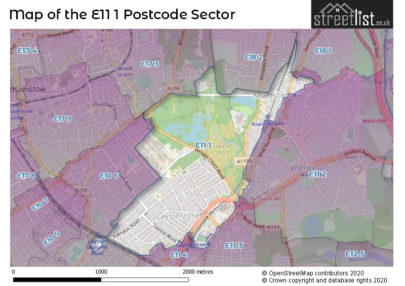
The E11 1 Postcode shares a border with E10 6 (LEYTON ), E17 3 (WALTHAMSTOW ), E18 1 (SOUTH WOODFORD , LONDON ), E11 2 (WANSTEAD , LONDON ), E11 3 (LEYTONSTONE , WANSTEAD ), E11 4 (LEYTONSTONE ) and E18 2 (SOUTH WOODFORD ).
Map of the E11 1 Postcode Sector
Explore the E11 1 postcode sector by using our interactive map.
The sector is within the post town of LONDON.
E11 1 is a postcode sector within the E11 postcode district which is within the E East London postcode area.
The Royal Mail delivery office for the E11 1 postal sector is the Leytonstone Sdelivery Office.
The area of the E11 1 postcode sector is 0.92 square miles which is 2.37 square kilometres or 586.56 square acres.
Your support helps keep this site running!
If you enjoy using this website, consider buying me a coffee to help cover hosting costs.


| E | 1 | 1 | - | 1 | X | X |
| E | 1 | 1 | Space | 1 | Letter | Letter |
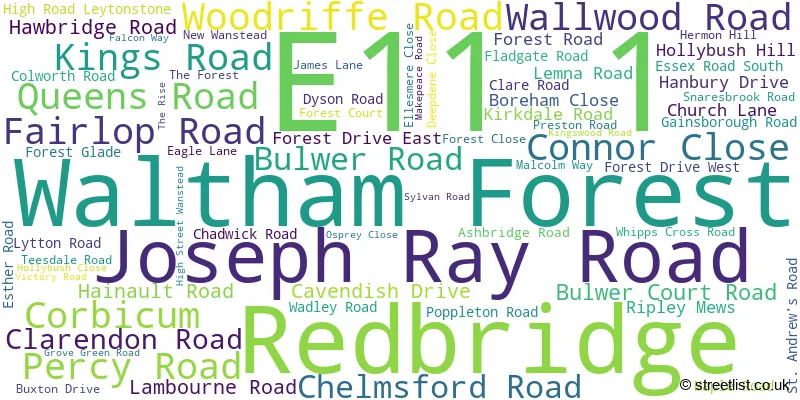
Official List of Streets
Waltham Forest (52 Streets)
(6 Streets)
Redbridge (17 Streets)
Unofficial Streets or Alternative Spellings
Redbridge
AUDLEY COURT CAMBRIDGE ROAD HERMITAGE CLOSE LONSDALE ROAD NELSON ROAD RIVENHALL GARDENS WELLINGTON ROAD WOODFORD NEW ROAD WOODFORD ROADWaltham Forest
AYLMER ROAD BROWNING ROAD BURGHLEY ROAD DRAYTON ROAD ESSEX ROAD FOREST RISE FORESTERS DRIVE HARVEY ROAD LEIGH ROAD MIDLAND ROAD NORLINGTON ROAD OAKHURST GARDENS PETERBOROUGH ROAD SCARBOROUGH ROAD SERBIN CLOSE SOUTHWEST ROAD AMBULANCE ROAD BACK ROAD BRIDGE ROAD EAGLE COURT HIGH STREET HOSPITAL ROAD INTEGER GARDENS KINGS PASSAGE MARGARET ROAD STATION APPROACH TEMPLE CLOSE THE PAVEMENT THE SIDINGSILFORD
EASTERN AVENUEHackney
LEA BRIDGE ROADWeather Forecast for E11 1
Weather Forecast for Walthamstow
| Time Period | Icon | Description | Temperature | Rain Probability | Wind |
|---|---|---|---|---|---|
| 00:00 to 03:00 | Overcast | 7.0°C (feels like 5.0°C) | 8.00% | SSW 7 mph | |
| 03:00 to 06:00 | Cloudy | 8.0°C (feels like 5.0°C) | 5.00% | SSW 9 mph | |
| 06:00 to 09:00 | Cloudy | 8.0°C (feels like 5.0°C) | 5.00% | SSW 9 mph | |
| 09:00 to 12:00 | Cloudy | 8.0°C (feels like 5.0°C) | 5.00% | SSW 11 mph | |
| 12:00 to 15:00 | Cloudy | 10.0°C (feels like 7.0°C) | 4.00% | SSW 13 mph | |
| 15:00 to 18:00 | Cloudy | 10.0°C (feels like 8.0°C) | 11.00% | SSW 13 mph | |
| 18:00 to 21:00 | Light rain | 10.0°C (feels like 7.0°C) | 57.00% | SSW 13 mph | |
| 21:00 to 00:00 | Partly cloudy (night) | 9.0°C (feels like 7.0°C) | 15.00% | WSW 9 mph |
| Time Period | Icon | Description | Temperature | Rain Probability | Wind |
|---|---|---|---|---|---|
| 00:00 to 03:00 | Clear night | 7.0°C (feels like 5.0°C) | 2.00% | WSW 7 mph | |
| 03:00 to 06:00 | Clear night | 6.0°C (feels like 3.0°C) | 0.00% | WSW 7 mph | |
| 06:00 to 09:00 | Clear night | 5.0°C (feels like 2.0°C) | 1.00% | WSW 7 mph | |
| 09:00 to 12:00 | Cloudy | 5.0°C (feels like 3.0°C) | 4.00% | WSW 4 mph | |
| 12:00 to 15:00 | Cloudy | 8.0°C (feels like 6.0°C) | 4.00% | W 4 mph | |
| 15:00 to 18:00 | Cloudy | 9.0°C (feels like 7.0°C) | 5.00% | NW 4 mph | |
| 18:00 to 21:00 | Cloudy | 6.0°C (feels like 5.0°C) | 4.00% | NNW 4 mph | |
| 21:00 to 00:00 | Partly cloudy (night) | 5.0°C (feels like 3.0°C) | 1.00% | N 4 mph |
| Time Period | Icon | Description | Temperature | Rain Probability | Wind |
|---|---|---|---|---|---|
| 00:00 to 03:00 | Partly cloudy (night) | 3.0°C (feels like 2.0°C) | 1.00% | N 4 mph | |
| 03:00 to 06:00 | Clear night | 2.0°C (feels like 0.0°C) | 1.00% | NNE 4 mph | |
| 06:00 to 09:00 | Clear night | 1.0°C (feels like -1.0°C) | 0.00% | NE 4 mph | |
| 09:00 to 12:00 | Sunny day | 2.0°C (feels like 0.0°C) | 1.00% | NE 4 mph | |
| 12:00 to 15:00 | Sunny day | 7.0°C (feels like 5.0°C) | 2.00% | NE 7 mph | |
| 15:00 to 18:00 | Sunny day | 8.0°C (feels like 6.0°C) | 2.00% | ENE 9 mph | |
| 18:00 to 21:00 | Clear night | 5.0°C (feels like 3.0°C) | 1.00% | ENE 7 mph | |
| 21:00 to 00:00 | Clear night | 4.0°C (feels like 1.0°C) | 2.00% | NE 7 mph |
| Time Period | Icon | Description | Temperature | Rain Probability | Wind |
|---|---|---|---|---|---|
| 00:00 to 03:00 | Clear night | 3.0°C (feels like 1.0°C) | 2.00% | NE 7 mph | |
| 03:00 to 06:00 | Partly cloudy (night) | 3.0°C (feels like 0.0°C) | 2.00% | NE 7 mph | |
| 06:00 to 09:00 | Cloudy | 3.0°C (feels like 0.0°C) | 5.00% | NE 7 mph | |
| 09:00 to 12:00 | Overcast | 3.0°C (feels like 0.0°C) | 10.00% | NE 9 mph | |
| 12:00 to 15:00 | Cloudy | 6.0°C (feels like 3.0°C) | 6.00% | NE 9 mph | |
| 15:00 to 18:00 | Partly cloudy (day) | 6.0°C (feels like 3.0°C) | 3.00% | NE 9 mph | |
| 18:00 to 21:00 | Clear night | 5.0°C (feels like 2.0°C) | 2.00% | NE 7 mph | |
| 21:00 to 00:00 | Overcast | 3.0°C (feels like 0.0°C) | 8.00% | NE 7 mph |
Schools and Places of Education Within the E11 1 Postcode Sector
Gwyn Jones Primary School
Community school
Hainault Road, London, , E11 1EU
Head: Mrs Sian Boutalbi
Ofsted Rating: Good
Inspection: 2018-10-16 (2303 days ago)
Website: Visit Gwyn Jones Primary School Website
Phone: 02085567904
Number of Pupils: 426
Leytonstone School
Community school
Colworth Road, London, , E11 1JD
Head: Ms Jessica McQuaid
Ofsted Rating: Good
Inspection: 2021-09-29 (1224 days ago)
Website: Visit Leytonstone School Website
Phone: 02089887420
Number of Pupils: 1002

House Prices in the E11 1 Postcode Sector
| Type of Property | 2018 Average | 2018 Sales | 2017 Average | 2017 Sales | 2016 Average | 2016 Sales | 2015 Average | 2015 Sales |
|---|---|---|---|---|---|---|---|---|
| Detached | £1,167,000 | 5 | £841,667 | 3 | £1,001,980 | 5 | £987,600 | 5 |
| Semi-Detached | £751,899 | 12 | £710,833 | 6 | £786,375 | 7 | £654,746 | 15 |
| Terraced | £661,590 | 36 | £617,426 | 43 | £613,956 | 34 | £517,717 | 50 |
| Flats | £371,742 | 71 | £343,005 | 115 | £364,613 | 135 | £309,597 | 131 |
Important Postcodes E11 1 in the Postcode Sector
E11 1AA is the postcode for Royal Mail, Leytonstone Delivery Office, 6 Joseph Ray Road
E11 1BN is the postcode for Allum Medical Centre, Fairlop Road
E11 1BS is the postcode for London Borough Of Waltham Forest, George Mason Lodge, Chelmsford Road, and George Mason Lodge, Chelmsford Road
E11 1EU is the postcode for Gwyn Jones Primary School, 219 Hainault Road, MAIN SCHOOL, Gwyn Jones Primary School, 219 Hainault Road, and MAIN SCHOOL, 219 Hainault Road
E11 1FE is the postcode for Waltham Forest Borough Based Custody Centre, Boreham Close, and Waltham Forest Borough Custody Centre, Boreham Close
E11 1GA is the postcode for Greenman Medical Centre, 1 Hanbury Drive
E11 1HG is the postcode for Leytonstone Library, 6 Church Lane, and London Borough of Waltham Forest, Leytonstone Library, 6 Church Lane
E11 1HP is the postcode for Waltham Forest Pct, Kirkdale House, 7 Kirkdale Road
E11 1JD is the postcode for DRAMA / MUSIC BLOCK, Leytonstone School, Colworth Road, PRACTICAL/ SCIENCE BLOCK, Leytonstone School, Colworth Road, LEYTONSTONE SCHOOL, 159 COLWORTH ROAD, LEYTONSTONE, Leytonstone School, 159 Colworth Road, PRACTICAL/SCIENCE BLOCK, LEYTONSTONE SCHOOL, COLWORTH ROAD, Practical / Science Block, Leytonstone School, Colworth Road, and Leytonstone Community Sports Centre, Colworth Road
E11 1JJ is the postcode for ROBART HOUSE, 1-3 Lemna Road, Benefits Agency, Lemna Road, and 1-3 Lemna Road
E11 1NR is the postcode for EYE TREATMENT CENTRE, Barts Health NHS Trust, Whipps Cross University Hospital, ICU & ACORN UNIT, Barts Health NHS Trust, Whipps Cross University Hospital, PLANE TREE BUILDING, Barts Health NHS Trust, Whipps Cross University Hospital, LSBU at Whipps Cross, London South Bank University, MAIN HOSPITAL BUILDING, Barts Health NHS Trust, Whipps Cross University Hospital, PLANE TREE BUILDING PHASE 1 AND 2, Barts Health NHS Trust, Whipps Cross University Hospital, ACCIDENT & EMERGENCY, Barts Health NHS Trust, Whipps Cross University Hospital, MARGARET CENTRE, Barts Health NHS Trust, Whipps Cross University Hospital, Barts Health NHS Trust, Whipps Cross University Hospital, MATERNITY BUILDING, Barts Health NHS Trust, Whipps Cross University Hospital, NEW ACCIDENT & EMERGENCY (EUCC), Barts Health NHS Trust, Whipps Cross University Hospital, CHEST CLINIC, Barts Health NHS Trust, Whipps Cross University Hospital, MAIN ENTRANCE, Barts Health NHS Trust, Whipps Cross University Hospital, CONNAUGHT DAY HOSPITAL, Barts Health NHS Trust, Whipps Cross University Hospital, and X RAY, Barts Health NHS Trust, Whipps Cross University Hospital
E11 1NU is the postcode for North East London NHS Foundation Trust, Woodbury Unit, and Woodbury Unit, 178 James Lane
E11 1QW is the postcode for ANNEXE, Snaresbrook Crown Court, 75 Hollybush Hill, and Snaresbrook Crown Court, 75 Hollybush Hill
E11 1UU is the postcode for Wanstead Hospital, Makepeace Road, and Forest Healthcare Trust, Heronwood, Makepeace Road
| The E11 1 Sector is within these Local Authorities |
|
|---|---|
| The E11 1 Sector is within these Counties |
|
| The E11 1 Sector is within these Water Company Areas |
|