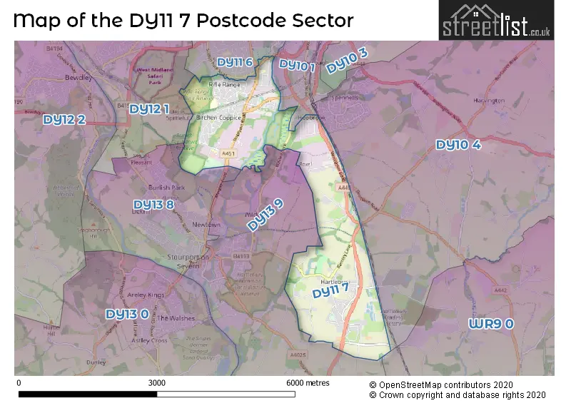
A wide range of spatial data has been analysed to present this overview of the DY11 7 Postcode sector. If you would like anything added, please contact us.
The DY11 7 postcode sector is within the county of Worcestershire.
Did you know? According to the 2021 Census, the DY11 7 postcode sector is home to a bustling 8,599 residents!
Given that each sector allows for 400 unique postcode combinations. Letters C, I, K, M, O and V are not allowed in the last two letters of a postcode. With 225 postcodes already in use, this leaves 175 units available.
The largest settlement in the DY11 7 postal code is KIDDERMINSTER followed by Hartlebury, and Waresley.
The DY11 7 Postcode shares a border with WR9 0 (Ombersley, DROITWICH, Hampton Lovett), DY10 4 (KIDDERMINSTER, Chaddesley Corbett, Hartlebury), DY11 6 (KIDDERMINSTER), DY12 1 (BEWDLEY, Shatterford, Trimpley), DY13 9 (STOURPORT-ON-SEVERN, Titton, Crossway Green), DY10 1 (KIDDERMINSTER) and DY13 8 (STOURPORT-ON-SEVERN).
Map of the DY11 7 Postcode Sector
Explore the DY11 7 postcode sector by using our interactive map.
The sector is within the post town of KIDDERMINSTER.
DY11 7 is a postcode sector within the DY11 postcode district which is within the DY Dudley postcode area.
The Royal Mail delivery office for the DY11 7 postal sector is the Kidderminster Delivery Office.
The area of the DY11 7 postcode sector is 4.17 square miles which is 10.79 square kilometres or 2,666.85 square acres.
Waterways within the DY11 7 postcode sector include the Staffordshire & Worcestershire Canal.
Your support helps keep this site running!
If you enjoy using this website, consider buying me a coffee to help cover hosting costs.


| D | Y | 1 | 1 | - | 7 | X | X |
| D | Y | 1 | 1 | Space | 7 | Letter | Letter |
Official List of Streets
KIDDERMINSTER (88 Streets)
Hartlebury (29 Streets)
(12 Streets)
Torton (5 Streets)
Waresley (4 Streets)
Summerfield (3 Streets)
Low Hill (1 Streets)
Unofficial Streets or Alternative Spellings
Hartlebury
DROITWICH ROADStone
STANKLYN LANE ARTHUR DRIVE ARTHUR DRIVE (ROAD 2) BURGER KING DRIVETHRU EASTER PARK EDWIN AVENUE EDWIN AVENUE (ROAD 4) FOLEY AVENUE FOLEY DRIVE FOLEY GROVE FREDERICK ROAD (ROAD 1) JUBILEE DRIVE NORTH JUBILEE DRIVE SOUTH LEAPGATE LANE LEAPGATE OLD RAILWAY LINE MATTHEW LANE (ROAD 3) OLDINGTON LANE PARKER PLACE RECTORY LANE RICKETS CLOSE ROWLAND WAY (ROAD 1A) WATERLADE CLOSE WATERLANE CLOSEKIDDERMINSTER
HUMPHRIES DRIVE PARK LANE RHUDDLAN WAY SUTTON PARK ROAD SUTTON ROADClent
WORCESTER ROADSTOURPORT-ON-SEVERN
HARTLEBURY ROAD KINGSWAY MINSTER ROAD WILDEN LANEWeather Forecast for DY11 7
Weather Forecast for
Schools and Places of Education Within the DY11 7 Postcode Sector
Birchen Coppice Academy
Academy sponsor led
Woodbury Road, Kidderminster, Worcestershire, DY11 7JJ
Head: Mrs Sandra Pennington
Ofsted Rating: Serious Weaknesses
Inspection: 2022-05-05 (1003 days ago)
Website: Visit Birchen Coppice Academy Website
Phone: 01562823582
Number of Pupils: 205
Cambian New Elizabethan School
Other independent special school
Quarry Bank, , , DY11 7TE
Head: Mrs Carrie McConomy
Ofsted Rating: Requires improvement
Inspection: 2022-04-07 (1031 days ago)
Website: Visit Cambian New Elizabethan School Website
Phone: 01299250258
Number of Pupils: 44
Continu Plus Academy
Free schools alternative provision
Finepoint, Kidderminster, Worcestershire, DY11 7FB
Head: Ms Sara Devo
Ofsted Rating: Outstanding
Inspection: 2022-02-10 (1087 days ago)
Website: Visit Continu Plus Academy Website
Phone: 01562822463
Number of Pupils: 34
Foley Park Primary Academy
Academy converter
Northumberland Avenue, Kidderminster, Worcestershire, DY11 7AW
Head: Miss Soneeta Reynolds
Ofsted Rating: Good
Inspection: 2022-07-14 (933 days ago)
Website: Visit Foley Park Primary Academy Website
Phone: 01562823857
Number of Pupils: 241
Hartlebury CofE Primary School
Academy converter
The Village, Kidderminster, Worcestershire, DY11 7TD
Head: Mrs Sophie Bartlett
Ofsted Rating: Good
Inspection: 2020-01-23 (1836 days ago)
Website: Visit Hartlebury CofE Primary School Website
Phone: 01299250312
Number of Pupils: 170

House Prices in the DY11 7 Postcode Sector
| Type of Property | 2018 Average | 2018 Sales | 2017 Average | 2017 Sales | 2016 Average | 2016 Sales | 2015 Average | 2015 Sales |
|---|---|---|---|---|---|---|---|---|
| Detached | £356,316 | 37 | £321,743 | 90 | £304,974 | 91 | £282,451 | 40 |
| Semi-Detached | £170,234 | 41 | £166,106 | 56 | £165,565 | 38 | £155,233 | 67 |
| Terraced | £132,872 | 18 | £157,087 | 38 | £144,038 | 25 | £152,101 | 39 |
| Flats | £228,750 | 2 | £189,450 | 5 | £97,500 | 1 | £101,915 | 6 |
Important Postcodes DY11 7 in the Postcode Sector
DY11 7AW is the postcode for Foley Park Community Primary School, Northumberland Avenue, and Foley Park Primary School, Northumberland Avenue
DY11 7DT is the postcode for Places for People Leisure Management Ltd, Wyre Forest Leisure Centre, Silverwoods Way, and Wyre Forest Leisure Centre, Silverwoods Way
DY11 7FB is the postcode for CONTINU PLUS ACADEMY, FINEPOINT WAY, KIDDERMINSTER, and Continu Plus Academy, Finepoint Way
DY11 7JJ is the postcode for Birchen Coppice Primary School Community Centre, Woodbury Road, Birchen Coppice First & Middle School, Woodbury Road, Birchen Coppice Primary School, Woodbury Road, Birchen Coppice Primary Academy, Woodbury Road, Kidderminster, and Tree Tops Childrens Centre, Woodbury Road
DY11 7RD is the postcode for Driver and Vehicle Standards Agency, Worcester Road, Summerfield, and Driver and Vehicle Standards Agency, Worcester Road
DY11 7TD is the postcode for Hartlebury C of E Primary School, The Village, and Hartlebury C of E Primary School, The Village, Hartlebury
DY11 7WF is the postcode for Wyre Forest District Council, Wyre Forest House, Finepoint Way
DY11 7XZ is the postcode for Worcester County Museum, Hartlebury Castle,, Worcester County Museum, Hartlebury Castle,, Hartlebury, and GIFT SHOP, Worcester County Museum, Hartlebury Castle,
| The DY11 7 Sector is within these Local Authorities |
|
|---|---|
| The DY11 7 Sector is within these Counties |
|
| The DY11 7 Sector is within these Water Company Areas |
|