
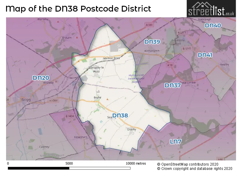
Map of the DN38 Postcode District
Explore the postcode district by using our interactive map.
Circles represent recorded crime; the larger the circle, the higher the crime rates.
Your support helps keep this site running!
If you enjoy using this website, consider buying me a coffee to help cover hosting costs.
Where is the DN38 District?
To give you an idea where the district is located we have created the following table showing nearby towns.
Nearest Towns to DN38
| Town | Distance (miles) | Direction |
|---|---|---|
| Brigg | 4.33 | W |
| Immingham | 8.17 | ENE |
| Barton-upon-Humber | 9.28 | NNW |
| Kirton in Lindsey | 10.20 | WSW |
| Scunthorpe | 11.21 | WNW |
| Winterton | 11.28 | NW |
| Market Rasen | 11.72 | S |
| Hessle | 11.84 | N |
| Grimsby | 12.28 | E |
| Kingston upon Hull | 13.27 | N |
| Cleethorpes | 14.48 | E |
| Hedon | 14.81 | NNE |
| Cottingham | 15.68 | N |
| South Cave | 17.34 | NNW |
| Epworth | 18.24 | W |
| Wragby | 18.79 | S |
| Crowle | 18.92 | W |
| Gainsborough | 19.39 | WSW |
| Beverley | 20.07 | N |
| Louth | 20.29 | SE |
The post town for this district is BARNETBY.
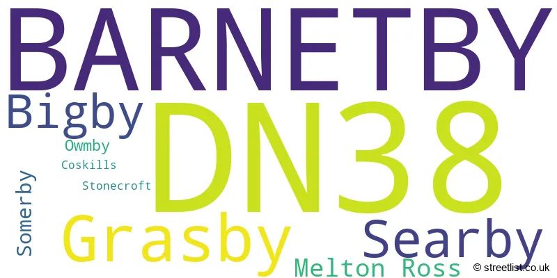
Postcode Information for District DN38 (Total Geographical Postcodes: 135)
| Location | Post Town | Sector | Number of Postcodes |
|---|---|---|---|
| BARNETBY | BARNETBY | DN38 6 | 86 |
| Grasby | BARNETBY | DN38 6 | 17 |
| Searby | BARNETBY | DN38 6 | 10 |
| Bigby | BARNETBY | DN38 6 | 8 |
| Melton Ross | BARNETBY | DN38 6 | 6 |
| Somerby | BARNETBY | DN38 6 | 4 |
| Owmby | BARNETBY | DN38 6 | 2 |
| Coskills | BARNETBY | DN38 6 | 1 |
| Stonecroft | BARNETBY | DN38 6 | 1 |
In the DN38 postcode district in Lincolnshire, the primary settlement is Barnetby, which has the highest count. Other significant settlements in the area include Bigby, Grasby, Melton Ross, Searby, and Somerby. The most significant post town in this postcode district is Barnetby.
When it comes to local government, postal geography often disregards political borders. However, this district intersects the following councils: the district mostly encompasses the North Lincolnshire (B) (63 postal codes), and finally, the West Lindsey District area (41 postal codes).
The largest settlement in the DN38 postal code is BARNETBY followed by Grasby, and Melton Ross.
The DN38 Postcode shares a border with DN20 (BRIGG, Broughton, Hibaldstow) and LN7 (Caistor, North Kelsey, Nettleton).
Postcode Sectors


Dentists in the DN38 District
No dentists found in this district.
Doctors in the DN38 District
| # | Name | Address | Type | Contact |
|---|---|---|---|---|
| 1 | Barnetby Medical Centre | , BARNETBY , SOUTH HUMBERSIDE , DN38 6HZ | GP PRACTICE |
Chemists in the DN38 District
No Chemists found in this district.
Opticians in the DN38 District
No Opticians found in this district.
Schools in the Sector
Grasby All Saints Church of England Primary School
Phase: Primary
Address: Vicarage Lane , Grasby , Barnetby
Postcode: DN38 6AU
Headteacher: Mrs Zoe Hyams (Headteacher)
Ofsted Rating: Good
St Barnabas CofE Primary School, Barnetby
Phase: Primary
Address: St Barnabas Road , Barnetby
Postcode: DN38 6JD
Headteacher: Mr Marc Grinhaff (Headteacher)
Ofsted Rating: Requires improvement
Stations in the Sector
Barnetby
CRS Code: BTB
Operator: TP
Line: Sheffield to Lincoln line|South Humberside main line|Newark to Grimsby line
Company: TransPennine Express
Accessable Motorway Junctions
M180 J5
Average Driving Time from within the district: 5.64
Average Driving Distance: 2.66
Number of Postcodes that can access the Motorway Junction: 103
M180 J4
Average Driving Time from within the district: 10.46
Average Driving Distance: 8.15
Number of Postcodes that can access the Motorway Junction: 103
M180 J3
Average Driving Time from within the district: 20.47
Average Driving Distance: 18.38
Number of Postcodes that can access the Motorway Junction: 103
M180 J2
Average Driving Time from within the district: 21.44
Average Driving Distance: 19.49
Number of Postcodes that can access the Motorway Junction: 103
M62 J38
Average Driving Time from within the district: 28.01
Average Driving Distance: 23.40
Number of Postcodes that can access the Motorway Junction: 103
Weather Forecast for Humberside Airport
| Time Period | Icon | Description | Temperature | Rain Probability | Wind |
|---|---|---|---|---|---|
| 12:00 to 15:00 | Overcast | 6.0°C (feels like 3.0°C) | 8.00% | S 13 mph | |
| 15:00 to 18:00 | Overcast | 7.0°C (feels like 3.0°C) | 9.00% | S 13 mph | |
| 18:00 to 21:00 | Overcast | 5.0°C (feels like 2.0°C) | 9.00% | S 11 mph | |
| 21:00 to 00:00 | Cloudy | 5.0°C (feels like 1.0°C) | 8.00% | S 11 mph |
| Time Period | Icon | Description | Temperature | Rain Probability | Wind |
|---|---|---|---|---|---|
| 00:00 to 03:00 | Partly cloudy (night) | 3.0°C (feels like -1.0°C) | 2.00% | S 13 mph | |
| 03:00 to 06:00 | Partly cloudy (night) | 2.0°C (feels like -2.0°C) | 2.00% | S 13 mph | |
| 06:00 to 09:00 | Partly cloudy (night) | 2.0°C (feels like -3.0°C) | 2.00% | S 13 mph | |
| 09:00 to 12:00 | Sunny day | 2.0°C (feels like -2.0°C) | 2.00% | S 11 mph | |
| 12:00 to 15:00 | Sunny day | 5.0°C (feels like 2.0°C) | 3.00% | S 13 mph | |
| 15:00 to 18:00 | Sunny day | 7.0°C (feels like 4.0°C) | 2.00% | SSW 11 mph | |
| 18:00 to 21:00 | Clear night | 4.0°C (feels like 1.0°C) | 2.00% | SSW 9 mph | |
| 21:00 to 00:00 | Clear night | 4.0°C (feels like 0.0°C) | 1.00% | SSW 11 mph |
| Time Period | Icon | Description | Temperature | Rain Probability | Wind |
|---|---|---|---|---|---|
| 00:00 to 03:00 | Clear night | 3.0°C (feels like -1.0°C) | 1.00% | SSW 9 mph | |
| 03:00 to 06:00 | Partly cloudy (night) | 3.0°C (feels like -1.0°C) | 2.00% | SSW 11 mph | |
| 06:00 to 09:00 | Cloudy | 3.0°C (feels like -1.0°C) | 5.00% | SSW 11 mph | |
| 09:00 to 12:00 | Cloudy | 4.0°C (feels like 0.0°C) | 5.00% | SSW 11 mph | |
| 12:00 to 15:00 | Cloudy | 7.0°C (feels like 3.0°C) | 5.00% | SSW 16 mph | |
| 15:00 to 18:00 | Cloudy | 8.0°C (feels like 5.0°C) | 5.00% | SSW 16 mph | |
| 18:00 to 21:00 | Partly cloudy (night) | 7.0°C (feels like 3.0°C) | 2.00% | SSW 13 mph | |
| 21:00 to 00:00 | Partly cloudy (night) | 6.0°C (feels like 2.0°C) | 3.00% | SSW 16 mph |
| Time Period | Icon | Description | Temperature | Rain Probability | Wind |
|---|---|---|---|---|---|
| 00:00 to 03:00 | Cloudy | 6.0°C (feels like 2.0°C) | 6.00% | SSW 16 mph | |
| 03:00 to 06:00 | Cloudy | 7.0°C (feels like 3.0°C) | 13.00% | SSW 16 mph | |
| 06:00 to 09:00 | Cloudy | 7.0°C (feels like 3.0°C) | 14.00% | SSW 18 mph | |
| 09:00 to 12:00 | Partly cloudy (day) | 7.0°C (feels like 3.0°C) | 12.00% | SSW 16 mph | |
| 12:00 to 15:00 | Cloudy | 9.0°C (feels like 6.0°C) | 16.00% | SSW 18 mph | |
| 15:00 to 18:00 | Cloudy | 10.0°C (feels like 7.0°C) | 15.00% | SW 16 mph | |
| 18:00 to 21:00 | Cloudy | 8.0°C (feels like 6.0°C) | 11.00% | SW 13 mph | |
| 21:00 to 00:00 | Partly cloudy (night) | 7.0°C (feels like 4.0°C) | 8.00% | WSW 11 mph |
| Postal Sector | Delivery Office |
|---|---|
| DN38 6 | Brigg Delivery Office |
| D | N | 3 | 8 | - | X | X | X |
| D | N | 3 | 8 | Space | Numeric | Letter | Letter |
Street List for the DN38 District
Current Monthly Rental Prices
| # Bedrooms | Min Price | Max Price | Avg Price |
|---|
Current House Prices
| # Bedrooms | Min Price | Max Price | Avg Price |
|---|---|---|---|
| £700,000 | £700,000 | £700,000 | |
| 2 | £195,000 | £225,000 | £210,000 |
| 3 | £145,000 | £375,000 | £239,127 |
| 4 | £175,000 | £700,000 | £405,714 |
| 5 | £425,000 | £1,150,000 | £683,332 |
| 10 | £285,000 | £285,000 | £285,000 |
| 13 | £350,000 | £350,000 | £350,000 |
Estate Agents
| Logo | Name | Brand Name | Address | Contact Number |
|---|---|---|---|---|
 | Brigg | Newton Fallowell | Unit 1, 2 Wrawby Street, Brigg, DN20 8JH | 01652 783030 |
 | Brigg | Paul Fox | 10 Market Place, Brigg, DN20 8ES | 01652 248427 |
 | Grimsby | Fine & Country | Osborne Chambers 25 Osborne Street, Grimsby, DN31 1EY | 01472 867880 |
 | Grimsby | Reeds Rains | 6 Bethlehem Street, Grimsby, DN31 1JU | 01472 404505 |
 | Brigg | Lovelle Estate Agency | The Old Chapel Wrawby Street, Brigg, DN20 8JJ | 01652 248422 |
Yearly House Price Averages for the District
| Type of Property | 2018 Average | 2018 Sales | 2017 Average | 2017 Sales | 2016 Average | 2016 Sales | 2015 Average | 2015 Sales |
|---|---|---|---|---|---|---|---|---|
| Detached | £264,775 | 18 | £236,454 | 34 | £272,052 | 28 | £226,105 | 19 |
| Semi-Detached | £140,073 | 13 | £140,808 | 13 | £116,606 | 9 | £125,385 | 13 |
| Terraced | £80,062 | 8 | £116,500 | 4 | £84,650 | 10 | £91,840 | 5 |
| Flats | £0 | 0 | £0 | 0 | £0 | 0 | £0 | 0 |