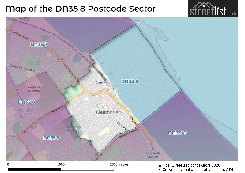
A wide range of spatial data has been analysed to present this overview of the DN35 8 Postcode sector. If you would like anything added, please contact us.
The DN35 8 postcode sector is within the county of Lincolnshire.
Did you know? According to the 2021 Census, the DN35 8 postcode sector is home to a bustling 7,589 residents!
Given that each sector allows for 400 unique postcode combinations. Letters C, I, K, M, O and V are not allowed in the last two letters of a postcode. With 208 postcodes already in use, this leaves 192 units available.
The DN35 8 postal code covers the settlement of CLEETHORPES.
The DN35 8 Postcode shares a border with DN32 8 (GRIMSBY, Old Clee), DN35 7 (CLEETHORPES), DN35 9 (CLEETHORPES) and DN35 0 (CLEETHORPES).
Map of the DN35 8 Postcode Sector
Explore the DN35 8 postcode sector by using our interactive map.
The sector is within the post town of CLEETHORPES.
DN35 8 is a postcode sector within the DN35 postcode district which is within the DN Doncaster postcode area.
The Royal Mail delivery office for the DN35 8 postal sector is the Grimsby Delivery Office.
The area of the DN35 8 postcode sector is 0.51 square miles which is 1.32 square kilometres or 325.86 square acres.
Your support helps keep this site running!
If you enjoy using this website, consider buying me a coffee to help cover hosting costs.


| D | N | 3 | 5 | - | 8 | X | X |
| D | N | 3 | 5 | Space | 8 | Letter | Letter |
Official List of Streets
CLEETHORPES (104 Streets)
Unofficial Streets or Alternative Spellings
Weather Forecast for DN35 8
Weather Forecast for Cleethorpes (Beach)
Schools and Places of Education Within the DN35 8 Postcode Sector
St Peter's CofE Primary School
Academy converter
Cambridge Street, Cleethorpes, North East Lincolnshire, DN35 8LW
Head: Mr Lee Dolphin
Ofsted Rating: Good
Inspection: 2019-07-02 (2031 days ago)
Website: Visit St Peter's CofE Primary School Website
Phone: 01472691964
Number of Pupils: 180
Thrunscoe Primary and Nursery Academy
Academy converter
Trinity Road, Cleethorpes, Lincolnshire, DN35 8UL
Head: Mr Simon Bate
Ofsted Rating: Good
Inspection: 2020-03-12 (1777 days ago)
Website: Visit Thrunscoe Primary and Nursery Academy Website
Phone: 01472320781
Number of Pupils: 310

House Prices in the DN35 8 Postcode Sector
| Type of Property | 2018 Average | 2018 Sales | 2017 Average | 2017 Sales | 2016 Average | 2016 Sales | 2015 Average | 2015 Sales |
|---|---|---|---|---|---|---|---|---|
| Detached | £179,833 | 3 | £208,000 | 1 | £255,667 | 3 | £173,500 | 5 |
| Semi-Detached | £145,736 | 36 | £139,667 | 41 | £135,740 | 38 | £128,023 | 26 |
| Terraced | £111,255 | 109 | £100,483 | 120 | £106,518 | 115 | £99,915 | 83 |
| Flats | £96,054 | 14 | £100,464 | 14 | £86,142 | 19 | £98,088 | 8 |
Important Postcodes DN35 8 in the Postcode Sector
DN35 8AW is the postcode for Humberside Police, Police Station, 45-47 Princes Road
DN35 8BL is the postcode for Humberside Fire & Rescue Service, Fire Station, Poplar Road
DN35 8DS is the postcode for Former Bursar Primary Academy, Bursar Street, and EARLY YEARS FOUNDATION STAGE ANNEX, Former Bursar Primary Academy, Bursar Street
DN35 8EB is the postcode for Cleethorpes Primary Care Centre, St. Hughs Avenue, and Cleethorpes Primary Care Centre, St Hughs Avenue
DN35 8LG is the postcode for North East Lincolnshire Council, Cleethorpes Library, Alexandra Road
DN35 8LL is the postcode for The Knoll, Knoll Street
DN35 8LN is the postcode for CIVIC OFFICES, KNOLL STREET, CLEETHORPES, Civic Offices, Knoll Street, Cleethorpes Town Hall, Knoll Street, and CLEETHORPES TOWN HALL, KNOLL STREET, CLEETHORPES
DN35 8LW is the postcode for St Peters C of E Primary Academy, Cambridge Street, and St. Peters C of E Primary Academy, Cambridge Street
DN35 8NX is the postcode for TRUNSCOE CENTRE, Highgate, THRUNSCOE CENTRE, Highgate, and THRUNSCOE COMMUNITY LEARNING CENTRE, Highgate
DN35 8UL is the postcode for Thrunscoe Primary And Nursery Academy & Highgate Children's Centre, Trinity Road
DN35 8UN is the postcode for The Trin Centre, Trinity Road
| The DN35 8 Sector is within these Local Authorities |
|
|---|---|
| The DN35 8 Sector is within these Counties |
|
| The DN35 8 Sector is within these Water Company Areas |
|