A wide range of spatial data has been analysed to present this overview of the DH3 4 Postcode sector. If you would like anything added, please contact us.
The DH3 4 postcode sector stands on the Durham and Tyne & Wear border.
Did you know? According to the 2021 Census, the DH3 4 postcode sector is home to a bustling 5,901 residents!
Given that each sector allows for 400 unique postcode combinations. Letters C, I, K, M, O and V are not allowed in the last two letters of a postcode. With 168 postcodes already in use, this leaves 232 units available.
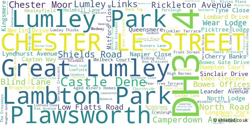
The largest settlement in the DH3 4 postal code is Great Lumley followed by CHESTER LE STREET, and Lambton Park.
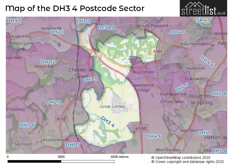
The DH3 4 Postcode shares a border with NE38 9 (WASHINGTON, High Rickleton, Picktree), DH1 5 (DURHAM, Pity Me, Aykley Heads), DH2 1 (Pelton, Ouston, Birtley), DH3 3 (CHESTER LE STREET), DH4 6 (HOUGHTON LE SPRING, West Rainton, Fencehouses), NE38 8 (WASHINGTON, Pattinson Industrial Estate), DH2 2 (CHESTER LE STREET, Pelton Fell, Newfield), DH3 2 (Birtley, CHESTER LE STREET) and DH4 7 (HOUGHTON LE SPRING, Penshaw, Shiney Row).
Map of the DH3 4 Postcode Sector
Explore the DH3 4 postcode sector by using our interactive map.
The sector is within the post town of CHESTER LE STREET.
DH3 4 is a postcode sector within the DH3 postcode district which is within the DH Durham postcode area.
The Royal Mail delivery office for the DH3 4 postal sector is the Chester Le Street Delivery Office.
The area of the DH3 4 postcode sector is 6.93 square miles which is 17.96 square kilometres or 4,438.19 square acres.
The DH3 4 postcode sector is crossed by the A167 Major A road.
The DH3 4 postcode sector is crossed by the A1M Major A road.
Waterways within the DH3 4 postcode sector include the Wear.
Your support helps keep this site running!
If you enjoy using this website, consider buying me a coffee to help cover hosting costs.

| D | H | 3 | - | 4 | X | X |
| D | H | 3 | Space | 4 | Letter | Letter |
Official List of Streets
Castle Dene (3 Streets)
(27 Streets)
Great Lumley (66 Streets)
CHESTER LE STREET (25 Streets)
Lambton Park (7 Streets)
Plawsworth (1 Streets)
Unofficial Streets or Alternative Spellings
Woodstone Village
LUMLEY NEW ROAD BLIND LANE INTERCHANGE CHESTER MOOR ROUNDABOUT CHESTER NEW BRIDGE CHURCH SIDE FENCE ROAD FROSTERLEY CLOSE HARBOUR WAGONWAY HIGH DRIVE LAMB BRIDGE LAMBTON BRIDGE LAMBTON PARK LARTINGTON CLOSE LUNEDALE DRIVE NEW BRIDGE NEWBRIDGE BANK NORTHLANDS ROUNDABOUT PAINTBALL VALLEY PEA FLATTS LANE ROPERY LANE THE AVENUE WAUGHS WAYPenshaw
CHESTER ROADLeamside
COCKEN ROADCHESTER LE STREET
NEWCASTLE ROAD PARK ROAD NORTH PARK ROAD SOUTH WIMBLEDON WALK WYTHENSHAWE WALKWASHINGTON
PICKTREE LANEPlawsworth
MILL LANEWeather Forecast for DH3 4
Weather Forecast for Durham I.C.G.
| Time Period | Icon | Description | Temperature | Rain Probability | Wind |
|---|---|---|---|---|---|
| 18:00 to 21:00 | Cloudy | 4.0°C (feels like 1.0°C) | 3.00% | S 9 mph | |
| 21:00 to 00:00 | Cloudy | 4.0°C (feels like 0.0°C) | 4.00% | S 11 mph |
| Time Period | Icon | Description | Temperature | Rain Probability | Wind |
|---|---|---|---|---|---|
| 00:00 to 03:00 | Cloudy | 4.0°C (feels like 0.0°C) | 5.00% | S 11 mph | |
| 03:00 to 06:00 | Cloudy | 4.0°C (feels like 0.0°C) | 5.00% | S 11 mph | |
| 06:00 to 09:00 | Cloudy | 4.0°C (feels like 0.0°C) | 5.00% | S 11 mph | |
| 09:00 to 12:00 | Cloudy | 4.0°C (feels like 0.0°C) | 4.00% | S 11 mph | |
| 12:00 to 15:00 | Partly cloudy (day) | 6.0°C (feels like 2.0°C) | 1.00% | S 11 mph | |
| 15:00 to 18:00 | Cloudy | 7.0°C (feels like 5.0°C) | 5.00% | SSW 9 mph | |
| 18:00 to 21:00 | Cloudy | 6.0°C (feels like 3.0°C) | 4.00% | SSW 7 mph | |
| 21:00 to 00:00 | Partly cloudy (night) | 5.0°C (feels like 2.0°C) | 1.00% | SSW 7 mph |
| Time Period | Icon | Description | Temperature | Rain Probability | Wind |
|---|---|---|---|---|---|
| 00:00 to 03:00 | Cloudy | 5.0°C (feels like 2.0°C) | 4.00% | SSW 7 mph | |
| 03:00 to 06:00 | Cloudy | 5.0°C (feels like 1.0°C) | 4.00% | SSW 9 mph | |
| 06:00 to 09:00 | Cloudy | 4.0°C (feels like 1.0°C) | 4.00% | SSW 11 mph | |
| 09:00 to 12:00 | Cloudy | 5.0°C (feels like 1.0°C) | 4.00% | SSW 11 mph | |
| 12:00 to 15:00 | Cloudy | 8.0°C (feels like 5.0°C) | 4.00% | SSW 13 mph | |
| 15:00 to 18:00 | Cloudy | 9.0°C (feels like 6.0°C) | 4.00% | SSW 13 mph | |
| 18:00 to 21:00 | Cloudy | 7.0°C (feels like 4.0°C) | 4.00% | SSW 13 mph | |
| 21:00 to 00:00 | Cloudy | 7.0°C (feels like 3.0°C) | 4.00% | SSW 16 mph |
| Time Period | Icon | Description | Temperature | Rain Probability | Wind |
|---|---|---|---|---|---|
| 00:00 to 03:00 | Cloudy | 7.0°C (feels like 3.0°C) | 4.00% | SSW 16 mph | |
| 03:00 to 06:00 | Cloudy | 7.0°C (feels like 3.0°C) | 4.00% | SSW 16 mph | |
| 06:00 to 09:00 | Cloudy | 7.0°C (feels like 4.0°C) | 4.00% | SSW 18 mph | |
| 09:00 to 12:00 | Cloudy | 8.0°C (feels like 4.0°C) | 5.00% | SSW 16 mph | |
| 12:00 to 15:00 | Cloudy | 10.0°C (feels like 7.0°C) | 6.00% | SSW 16 mph | |
| 15:00 to 18:00 | Cloudy | 10.0°C (feels like 7.0°C) | 7.00% | SW 13 mph | |
| 18:00 to 21:00 | Cloudy | 8.0°C (feels like 5.0°C) | 6.00% | SW 11 mph | |
| 21:00 to 00:00 | Clear night | 7.0°C (feels like 3.0°C) | 2.00% | WSW 11 mph |
| Time Period | Icon | Description | Temperature | Rain Probability | Wind |
|---|---|---|---|---|---|
| 00:00 to 03:00 | Clear night | 5.0°C (feels like 2.0°C) | 3.00% | WSW 11 mph | |
| 03:00 to 06:00 | Clear night | 4.0°C (feels like 1.0°C) | 1.00% | WSW 11 mph | |
| 06:00 to 09:00 | Clear night | 4.0°C (feels like 0.0°C) | 1.00% | WSW 9 mph | |
| 09:00 to 12:00 | Sunny day | 4.0°C (feels like 0.0°C) | 1.00% | WSW 9 mph | |
| 12:00 to 15:00 | Sunny day | 7.0°C (feels like 5.0°C) | 1.00% | WSW 9 mph | |
| 15:00 to 18:00 | Sunny day | 8.0°C (feels like 6.0°C) | 0.00% | WSW 9 mph | |
| 18:00 to 21:00 | Clear night | 5.0°C (feels like 2.0°C) | 0.00% | SW 7 mph | |
| 21:00 to 00:00 | Clear night | 3.0°C (feels like 1.0°C) | 0.00% | SW 7 mph |
Schools and Places of Education Within the DH3 4 Postcode Sector
Lumley Infant and Nursery School
Community school
Great Lumley, Chester le Street, County Durham, DH3 4JL
Head: Mrs Tracey Wilson
Ofsted Rating: Outstanding
Inspection: 2013-06-13 (4251 days ago)
Website: Visit Lumley Infant and Nursery School Website
Phone: 01913885292
Number of Pupils: 182
Lumley Junior School
Community school
Cocken Lane, Chester le Street, County Durham, DH3 4JJ
Head: Mrs Tracey Wilson
Ofsted Rating: Good
Inspection: 2018-09-11 (2335 days ago)
Website: Visit Lumley Junior School Website
Phone: 01913882310
Number of Pupils: 178
House Prices in the DH3 4 Postcode Sector
| Type of Property | 2018 Average | 2018 Sales | 2017 Average | 2017 Sales | 2016 Average | 2016 Sales | 2015 Average | 2015 Sales |
|---|---|---|---|---|---|---|---|---|
| Detached | £344,997 | 18 | £287,579 | 24 | £294,648 | 20 | £236,021 | 23 |
| Semi-Detached | £150,539 | 32 | £158,698 | 44 | £152,436 | 32 | £149,850 | 33 |
| Terraced | £133,126 | 10 | £185,045 | 11 | £141,762 | 17 | £146,092 | 13 |
| Flats | £96,429 | 7 | £62,500 | 7 | £59,000 | 1 | £50,000 | 1 |
Important Postcodes DH3 4 in the Postcode Sector
DH3 4BB is the postcode for Park View North Lodge School, Lombard Drive, MAIN BUILDING, Park View Community School, Lombard Drive, Park View Community School, Lombard Drive, TECHNOLOGY AND DESIGN BLOCK, Park View Community School, Lombard Drive, and PARK VIEW NORTH LODGE SCHOOL, LOMBARD DRIVE, CHESTER-LE-STREET
DH3 4JJ is the postcode for Lumley Junior School, Cocken Lane, Great Lumley, and Lumley Junior School, Cocken Lane
DH3 4JL is the postcode for Lumley Infant & Nursery School, Great Lumley
| The DH3 4 Sector is within these Local Authorities |
|
|---|---|
| The DH3 4 Sector is within these Counties |
|
| The DH3 4 Sector is within these Water Company Areas |
|