A wide range of spatial data has been analysed to present this overview of the DE72 2 Postcode sector. If you would like anything added, please contact us.
The DE72 2 postcode sector stands on the Derbyshire and Leicestershire border.
Did you know? According to the 2021 Census, the DE72 2 postcode sector is home to a bustling 4,445 residents!
Given that each sector allows for 400 unique postcode combinations. Letters C, I, K, M, O and V are not allowed in the last two letters of a postcode. With 110 postcodes already in use, this leaves 290 units available.
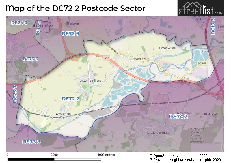
The largest settlement in the DE72 2 postal code is Shardlow followed by Aston-on-Trent, and Weston-on-Trent.
The DE72 2 Postcode shares a border with NG10 3 (Long Eaton), DE72 3 (Borrowash, Breaston, Draycott), DE73 6 (Chellaston), DE73 7 (Ticknall, Barrow-on-Trent, Stanton-by-Bridge), DE73 8 (Melbourne, Breedon-on-the-Hill) and DE74 2 (Castle Donington, Kegworth, Diseworth).
Map of the DE72 2 Postcode Sector
Explore the DE72 2 postcode sector by using our interactive map.
The sector is within the post town of DERBY.
DE72 2 is a postcode sector within the DE72 postcode district which is within the DE Derby postcode area.
The Royal Mail delivery office for the DE72 2 postal sector is the Derby Provincial Delivery Office.
The area of the DE72 2 postcode sector is 8.00 square miles which is 20.72 square kilometres or 5,119.51 square acres.
The DE72 2 postcode sector is crossed by the A6 Major A road.
The DE72 2 postcode sector is crossed by the M1 motorway.
The DE72 2 postcode sector is crossed by the A50 Major A road.
Waterways within the DE72 2 postcode sector include the River Trent, River Derwent, Trent & Mersey Canal, Trent and Mersey Canal.
Your support helps keep this site running!
If you enjoy using this website, consider buying me a coffee to help cover hosting costs.


| D | E | 7 | 2 | - | 2 | X | X |
| D | E | 7 | 2 | Space | 2 | Letter | Letter |
Official List of Streets
Shardlow (24 Streets)
(9 Streets)
Aston-on-Trent (51 Streets)
Weston-on-Trent (15 Streets)
Unofficial Streets or Alternative Spellings
Aston-on-Trent
LODGE MEWS POSEY LANEWeston-on-Trent
WESTON COURTLong Eaton
TAMWORTH ROADChellaston
SWARKESTONE ROADWeather Forecast for DE72 2
Weather Forecast for Donington Park
| Time Period | Icon | Description | Temperature | Rain Probability | Wind |
|---|---|---|---|---|---|
| 12:00 to 15:00 | Cloudy | 7.0°C (feels like 4.0°C) | 6.00% | SSW 11 mph | |
| 15:00 to 18:00 | Cloudy | 8.0°C (feels like 6.0°C) | 5.00% | SSW 11 mph | |
| 18:00 to 21:00 | Cloudy | 7.0°C (feels like 4.0°C) | 5.00% | SSW 9 mph | |
| 21:00 to 00:00 | Cloudy | 6.0°C (feels like 2.0°C) | 4.00% | SSW 11 mph |
| Time Period | Icon | Description | Temperature | Rain Probability | Wind |
|---|---|---|---|---|---|
| 00:00 to 03:00 | Cloudy | 5.0°C (feels like 2.0°C) | 4.00% | SSW 13 mph | |
| 03:00 to 06:00 | Cloudy | 6.0°C (feels like 2.0°C) | 5.00% | SSW 11 mph | |
| 06:00 to 09:00 | Cloudy | 7.0°C (feels like 3.0°C) | 5.00% | SSW 13 mph | |
| 09:00 to 12:00 | Cloudy | 8.0°C (feels like 4.0°C) | 8.00% | SSW 18 mph | |
| 12:00 to 15:00 | Cloudy | 10.0°C (feels like 6.0°C) | 13.00% | SSW 20 mph | |
| 15:00 to 18:00 | Light rain | 10.0°C (feels like 6.0°C) | 86.00% | SSW 20 mph | |
| 18:00 to 21:00 | Light rain shower (night) | 8.0°C (feels like 5.0°C) | 84.00% | SW 13 mph | |
| 21:00 to 00:00 | Clear night | 7.0°C (feels like 3.0°C) | 2.00% | SW 13 mph |
| Time Period | Icon | Description | Temperature | Rain Probability | Wind |
|---|---|---|---|---|---|
| 00:00 to 03:00 | Clear night | 5.0°C (feels like 1.0°C) | 0.00% | WSW 11 mph | |
| 03:00 to 06:00 | Clear night | 4.0°C (feels like 1.0°C) | 0.00% | WSW 9 mph | |
| 06:00 to 09:00 | Clear night | 3.0°C (feels like 0.0°C) | 1.00% | WSW 9 mph | |
| 09:00 to 12:00 | Cloudy | 3.0°C (feels like 1.0°C) | 4.00% | WSW 7 mph | |
| 12:00 to 15:00 | Cloudy | 7.0°C (feels like 4.0°C) | 4.00% | W 7 mph | |
| 15:00 to 18:00 | Cloudy | 7.0°C (feels like 5.0°C) | 4.00% | WNW 7 mph | |
| 18:00 to 21:00 | Clear night | 3.0°C (feels like 2.0°C) | 0.00% | WNW 4 mph | |
| 21:00 to 00:00 | Clear night | 1.0°C (feels like -1.0°C) | 0.00% | WNW 4 mph |
| Time Period | Icon | Description | Temperature | Rain Probability | Wind |
|---|---|---|---|---|---|
| 00:00 to 03:00 | Clear night | 0.0°C (feels like -2.0°C) | 0.00% | NW 2 mph | |
| 03:00 to 06:00 | Clear night | -1.0°C (feels like -3.0°C) | 0.00% | NNE 2 mph | |
| 06:00 to 09:00 | Clear night | -2.0°C (feels like -4.0°C) | 1.00% | NE 4 mph | |
| 09:00 to 12:00 | Sunny day | 0.0°C (feels like -2.0°C) | 3.00% | ENE 4 mph | |
| 12:00 to 15:00 | Sunny day | 5.0°C (feels like 4.0°C) | 0.00% | ENE 4 mph | |
| 15:00 to 18:00 | Sunny day | 7.0°C (feels like 5.0°C) | 0.00% | ENE 7 mph | |
| 18:00 to 21:00 | Clear night | 3.0°C (feels like 1.0°C) | 0.00% | ENE 7 mph | |
| 21:00 to 00:00 | Clear night | 2.0°C (feels like -1.0°C) | 1.00% | ENE 7 mph |
| Time Period | Icon | Description | Temperature | Rain Probability | Wind |
|---|---|---|---|---|---|
| 00:00 to 03:00 | Mist | 1.0°C (feels like -2.0°C) | 14.00% | ENE 7 mph | |
| 03:00 to 06:00 | Fog | 1.0°C (feels like -2.0°C) | 15.00% | NE 7 mph | |
| 06:00 to 09:00 | Fog | 1.0°C (feels like -2.0°C) | 16.00% | NE 7 mph | |
| 09:00 to 12:00 | Fog | 2.0°C (feels like -2.0°C) | 15.00% | NE 9 mph | |
| 12:00 to 15:00 | Cloudy | 4.0°C (feels like 1.0°C) | 6.00% | ENE 9 mph | |
| 15:00 to 18:00 | Sunny day | 5.0°C (feels like 2.0°C) | 2.00% | ENE 9 mph | |
| 18:00 to 21:00 | Clear night | 3.0°C (feels like 0.0°C) | 2.00% | NE 7 mph | |
| 21:00 to 00:00 | Cloudy | 2.0°C (feels like -1.0°C) | 5.00% | NE 7 mph |
Schools and Places of Education Within the DE72 2 Postcode Sector
Aston-on-Trent Primary School
Community school
Long Croft, Derby, Derbyshire, DE72 2UH
Head: Mr Sam Moore
Ofsted Rating: Good
Inspection: 2019-11-14 (1908 days ago)
Website: Visit Aston-on-Trent Primary School Website
Phone: 01332799478
Number of Pupils: 189
Shardlow Primary School
Academy converter
Shardlow Primary School London Road, Derby, Derbyshire, DE72 2GR
Head: Mrs Kylie Magner
Ofsted Rating: Good
Inspection: 2022-10-05 (852 days ago)
Website: Visit Shardlow Primary School Website
Phone: 01332792215
Number of Pupils: 97
Weston-on-Trent CofE (VA) Primary School
Voluntary aided school
Forrester Avenue, Derby, Derbyshire, DE72 2HX
Head: Mr Mark Hibbert
Ofsted Rating: Good
Inspection: 2023-12-07 (424 days ago)
Website: Visit Weston-on-Trent CofE (VA) Primary School Website
Phone: 01332700488
Number of Pupils: 149
House Prices in the DE72 2 Postcode Sector
| Type of Property | 2018 Average | 2018 Sales | 2017 Average | 2017 Sales | 2016 Average | 2016 Sales | 2015 Average | 2015 Sales |
|---|---|---|---|---|---|---|---|---|
| Detached | £371,142 | 59 | £339,592 | 27 | £338,060 | 36 | £338,030 | 44 |
| Semi-Detached | £239,800 | 15 | £245,718 | 19 | £239,643 | 7 | £204,556 | 17 |
| Terraced | £167,650 | 15 | £182,921 | 14 | £193,288 | 17 | £151,842 | 19 |
| Flats | £350,000 | 39 | £403,250 | 28 | £387,650 | 30 | £116,400 | 5 |
Important Postcodes DE72 2 in the Postcode Sector
DE72 2GR is the postcode for Shardlow Primary School, London Road
DE72 2HX is the postcode for Weston on Trent C of E Aided Primary School, Forrester Avenue
DE72 2UH is the postcode for Aston On Trent Primary School, Long Croft, Aston-On-Trent
| The DE72 2 Sector is within these Local Authorities |
|
|---|---|
| The DE72 2 Sector is within these Counties |
|
| The DE72 2 Sector is within these Water Company Areas |
|
Tourist Attractions within the DE72 2 Postcode Area
We found 1 visitor attractions within the DE72 postcode area
| Shardlow Heritage Centre |
|---|
| Visitor Centres |
| Heritage / Visitor Centre |
| View Shardlow Heritage Centre on Google Maps |