A wide range of spatial data has been analysed to present this overview of the DE55 4 Postcode sector. If you would like anything added, please contact us.
The DE55 4 postcode sector stands on the Derbyshire and Nottinghamshire border.
Did you know? According to the 2021 Census, the DE55 4 postcode sector is home to a bustling 8,135 residents!
Given that each sector allows for 400 unique postcode combinations. Letters C, I, K, M, O and V are not allowed in the last two letters of a postcode. With 187 postcodes already in use, this leaves 213 units available.
The largest settlement in the DE55 4 postal code is Somercotes followed by Riddings, and Pye Bridge.
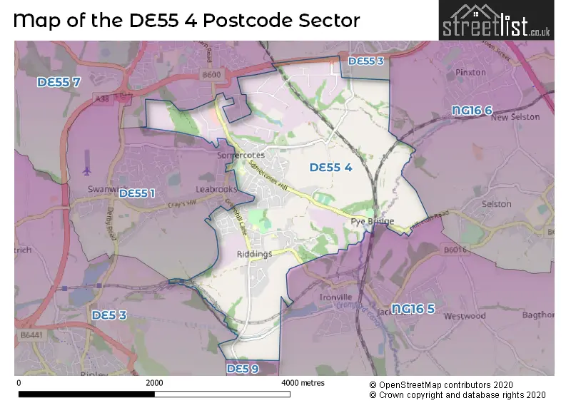
The DE55 4 Postcode shares a border with DE5 3 (RIPLEY, Pentrich, Butterley), DE55 7 (ALFRETON, South Wingfield, Oakerthorpe), NG16 5 (Brinsley, Underwood, Jacksdale), NG16 6 (Selston, Pinxton), DE5 9 (Codnor, Waingroves), DE55 3 (South Normanton) and DE55 1 (Swanwick, Leabrooks, Somercotes).
Map of the DE55 4 Postcode Sector
Explore the DE55 4 postcode sector by using our interactive map.
The sector is within the post town of ALFRETON.
DE55 4 is a postcode sector within the DE55 postcode district which is within the DE Derby postcode area.
The Royal Mail delivery office for the DE55 4 postal sector is the Alfreton Delivery Office.
The area of the DE55 4 postcode sector is 3.43 square miles which is 8.89 square kilometres or 2,195.95 square acres.
The DE55 4 postcode sector is crossed by the A38 Major A road.
Waterways within the DE55 4 postcode sector include the Erewash, Cromford Canal (disused).
Your support helps keep this site running!
If you enjoy using this website, consider buying me a coffee to help cover hosting costs.

| D | E | 5 | 5 | - | 4 | X | X |
| D | E | 5 | 5 | Space | 4 | Letter | Letter |
Official List of Streets
Riddings (57 Streets)
Pye Bridge (6 Streets)
(10 Streets)
Somercotes (68 Streets)
Unofficial Streets or Alternative Spellings
Somercotes
COUPLAND PLACE SLEETMOOR LANE WARWICK ROADIronville
BULLOCK LANE COACH ROAD NOTTINGHAM LANELeabrooks
DEVONSHIRE DRIVE GREENHILL LANE JAMES STREET SHERWOOD STREETButterley
COACH ROADCodnor
CODNOR LANEWeather Forecast for DE55 4
Weather Forecast for Alfreton
| Time Period | Icon | Description | Temperature | Rain Probability | Wind |
|---|---|---|---|---|---|
| 00:00 to 03:00 | Cloudy | 5.0°C (feels like 1.0°C) | 4.00% | SSW 11 mph | |
| 03:00 to 06:00 | Cloudy | 5.0°C (feels like 2.0°C) | 5.00% | SSW 13 mph | |
| 06:00 to 09:00 | Cloudy | 6.0°C (feels like 2.0°C) | 9.00% | SSW 13 mph | |
| 09:00 to 12:00 | Cloudy | 7.0°C (feels like 3.0°C) | 12.00% | SSW 16 mph | |
| 12:00 to 15:00 | Cloudy | 9.0°C (feels like 6.0°C) | 18.00% | SSW 18 mph | |
| 15:00 to 18:00 | Heavy rain | 9.0°C (feels like 6.0°C) | 89.00% | SSW 18 mph | |
| 18:00 to 21:00 | Light rain shower (night) | 7.0°C (feels like 4.0°C) | 80.00% | SW 13 mph | |
| 21:00 to 00:00 | Clear night | 6.0°C (feels like 2.0°C) | 2.00% | SW 11 mph |
| Time Period | Icon | Description | Temperature | Rain Probability | Wind |
|---|---|---|---|---|---|
| 00:00 to 03:00 | Clear night | 4.0°C (feels like 1.0°C) | 1.00% | WSW 11 mph | |
| 03:00 to 06:00 | Clear night | 3.0°C (feels like 0.0°C) | 0.00% | WSW 9 mph | |
| 06:00 to 09:00 | Clear night | 2.0°C (feels like 0.0°C) | 1.00% | SW 7 mph | |
| 09:00 to 12:00 | Cloudy | 3.0°C (feels like 0.0°C) | 4.00% | WSW 7 mph | |
| 12:00 to 15:00 | Cloudy | 6.0°C (feels like 4.0°C) | 5.00% | W 9 mph | |
| 15:00 to 18:00 | Partly cloudy (day) | 7.0°C (feels like 4.0°C) | 1.00% | WNW 9 mph | |
| 18:00 to 21:00 | Clear night | 3.0°C (feels like 1.0°C) | 0.00% | WNW 4 mph | |
| 21:00 to 00:00 | Clear night | 1.0°C (feels like -1.0°C) | 0.00% | WNW 4 mph |
| Time Period | Icon | Description | Temperature | Rain Probability | Wind |
|---|---|---|---|---|---|
| 00:00 to 03:00 | Clear night | 0.0°C (feels like -2.0°C) | 0.00% | NW 4 mph | |
| 03:00 to 06:00 | Clear night | 0.0°C (feels like -2.0°C) | 1.00% | NNW 2 mph | |
| 06:00 to 09:00 | Clear night | -1.0°C (feels like -3.0°C) | 1.00% | N 4 mph | |
| 09:00 to 12:00 | Sunny day | 1.0°C (feels like -1.0°C) | 2.00% | NNE 4 mph | |
| 12:00 to 15:00 | Sunny day | 5.0°C (feels like 4.0°C) | 0.00% | E 4 mph | |
| 15:00 to 18:00 | Sunny day | 6.0°C (feels like 4.0°C) | 0.00% | E 7 mph | |
| 18:00 to 21:00 | Clear night | 3.0°C (feels like 0.0°C) | 0.00% | ENE 7 mph | |
| 21:00 to 00:00 | Clear night | 1.0°C (feels like -1.0°C) | 1.00% | ENE 4 mph |
| Time Period | Icon | Description | Temperature | Rain Probability | Wind |
|---|---|---|---|---|---|
| 00:00 to 03:00 | Mist | 1.0°C (feels like -2.0°C) | 14.00% | NE 4 mph | |
| 03:00 to 06:00 | Fog | 1.0°C (feels like -2.0°C) | 15.00% | NE 7 mph | |
| 06:00 to 09:00 | Fog | 1.0°C (feels like -2.0°C) | 16.00% | NNE 7 mph | |
| 09:00 to 12:00 | Fog | 1.0°C (feels like -2.0°C) | 16.00% | NE 7 mph | |
| 12:00 to 15:00 | Cloudy | 3.0°C (feels like 0.0°C) | 6.00% | ENE 9 mph | |
| 15:00 to 18:00 | Partly cloudy (day) | 5.0°C (feels like 2.0°C) | 2.00% | ENE 9 mph | |
| 18:00 to 21:00 | Clear night | 3.0°C (feels like 0.0°C) | 2.00% | NE 7 mph | |
| 21:00 to 00:00 | Partly cloudy (night) | 2.0°C (feels like -1.0°C) | 2.00% | NE 7 mph |
Schools and Places of Education Within the DE55 4 Postcode Sector
Riddings Infant and Nursery School
Community school
West Street, Alfreton, Derbyshire, DE55 4EW
Head: Mrs Rachel Farnsworth
Ofsted Rating: Good
Inspection: 2019-05-08 (2099 days ago)
Website: Visit Riddings Infant and Nursery School Website
Phone: 01773602767
Number of Pupils: 219
Somercotes Infant and Nursery School
Academy sponsor led
Nottingham Road, Alfreton, Derbyshire, DE55 4LY
Head: Mrs Helina Kirkup
Ofsted Rating: Requires improvement
Inspection: 2022-02-16 (1084 days ago)
Website: Visit Somercotes Infant and Nursery School Website
Phone: 01773608678
Number of Pupils: 132
Somerlea Park Junior School
Academy sponsor led
Bank Street, Alfreton, Derbyshire, DE55 4JE
Head: Mrs Helina Kirkup
Ofsted Rating: Good
Inspection: 2022-01-19 (1112 days ago)
Website: Visit Somerlea Park Junior School Website
Phone: 01773602258
Number of Pupils: 137
House Prices in the DE55 4 Postcode Sector
| Type of Property | 2018 Average | 2018 Sales | 2017 Average | 2017 Sales | 2016 Average | 2016 Sales | 2015 Average | 2015 Sales |
|---|---|---|---|---|---|---|---|---|
| Detached | £178,169 | 26 | £194,250 | 36 | £184,351 | 35 | £169,883 | 27 |
| Semi-Detached | £126,526 | 48 | £123,872 | 54 | £113,494 | 48 | £100,758 | 42 |
| Terraced | £87,749 | 45 | £94,926 | 57 | £96,211 | 50 | £92,825 | 50 |
| Flats | £0 | 0 | £115,500 | 2 | £50,000 | 1 | £45,100 | 5 |
Important Postcodes DE55 4 in the Postcode Sector
DE55 4BW is the postcode for Riddings Junior School, Church Street
DE55 4EW is the postcode for Riddings Infant & Nursery School, West Street
DE55 4HA is the postcode for Somercotes Infant School, Victoria Street
DE55 4JE is the postcode for Somerlea Park Junior School, Bank Street
DE55 4JJ is the postcode for Somercotes Medical Centre, 22 Nottingham Road
DE55 4LY is the postcode for Somercotes Infant School, Nottingham Road
DE55 4QQ is the postcode for Eurocell Building Plastics, Birchwood Way
DE55 4QS is the postcode for Royal Mail, Alfreton Delivery Office, West Way
DE55 4RF is the postcode for Eurocell, Fairbrook House, Clover Nook Road, Cotes Park Industrial Estate
| The DE55 4 Sector is within these Local Authorities |
|
|---|---|
| The DE55 4 Sector is within these Counties |
|
| The DE55 4 Sector is within these Water Company Areas |
|