A wide range of spatial data has been analysed to present this overview of the DE45 1 Postcode sector. If you would like anything added, please contact us.
The DE45 1 postcode sector is within the county of Derbyshire.
Did you know? According to the 2021 Census, the DE45 1 postcode sector is home to a bustling 8,047 residents!
Given that each sector allows for 400 unique postcode combinations. Letters C, I, K, M, O and V are not allowed in the last two letters of a postcode. With 326 postcodes already in use, this leaves 74 units available.
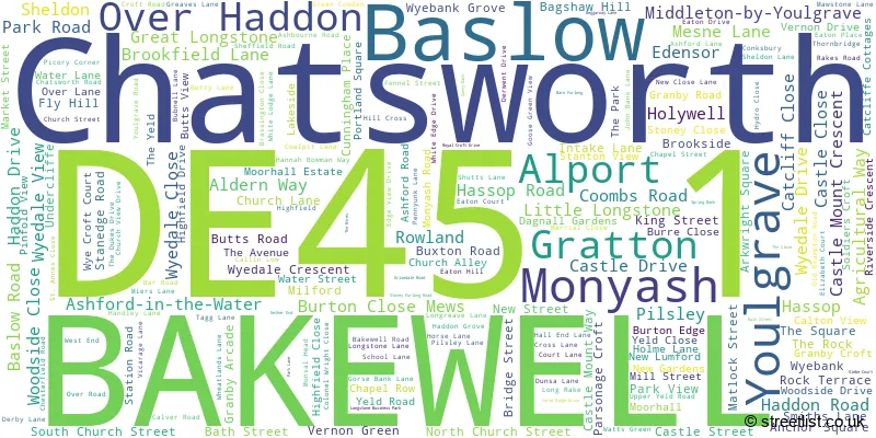
The largest settlement in the DE45 1 postal code is BAKEWELL followed by Youlgrave, and Baslow.
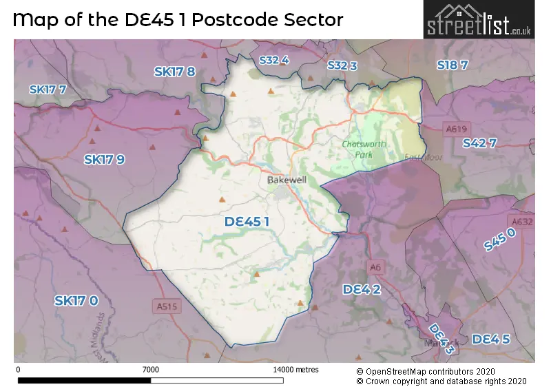
The DE45 1 Postcode shares a border with DE4 2 (Darley Dale, Winster, Bonsall), S18 7 (Barlow, Holmesfield, DRONFIELD), S32 3 (Calver), S32 4 (Stoney Middleton, Great Longstone), S32 5 (Eyam), S42 7 (Holymoorside, Walton, Ashgate), SK17 0 (Longnor, Hartington, Quarnford), SK17 8 (Tideswell, Dove Holes, Peak Dale) and SK17 9 (BUXTON, Taddington, Flagg).
Map of the DE45 1 Postcode Sector
Explore the DE45 1 postcode sector by using our interactive map.
The sector is within the post town of BAKEWELL.
DE45 1 is a postcode sector within the DE45 postcode district which is within the DE Derby postcode area.
The Royal Mail delivery office for the DE45 1 postal sector is the Bakewell Delivery Office.
The area of the DE45 1 postcode sector is 49.75 square miles which is 128.85 square kilometres or 31,840.17 square acres.
Waterways within the DE45 1 postcode sector include the Derwent, River Wye, River Bradford, Bar Brook, Umberley Brook, Emperor Stream, Blake Brook, Blackleach Brook, River Lathkill.
Your support helps keep this site running!
If you enjoy using this website, consider buying me a coffee to help cover hosting costs.


| D | E | 4 | 5 | - | 1 | X | X |
| D | E | 4 | 5 | Space | 1 | Letter | Letter |
Official List of Streets
BAKEWELL (96 Streets)
(66 Streets)
Youlgrave (22 Streets)
Monyash (12 Streets)
Baslow (31 Streets)
Over Haddon (7 Streets)
Great Longstone (16 Streets)
Ashford-in-the-Water (15 Streets)
Pilsley (5 Streets)
Edensor (1 Streets)
Rowland (2 Streets)
Hassop (1 Streets)
Unofficial Streets or Alternative Spellings
Rowsley
PARK LANEBAKEWELL
CALTON VIEWCalver
HASSOP ROADGreat Longstone
GLEBE COURTElton
DUDWOOD LANENewton Grange
BUXTON ROADWeather Forecast for DE45 1
Weather Forecast for Bakewell Youth Hostel
| Time Period | Icon | Description | Temperature | Rain Probability | Wind |
|---|---|---|---|---|---|
| 06:00 to 09:00 | Overcast | 3.0°C (feels like -1.0°C) | 10.00% | S 9 mph | |
| 09:00 to 12:00 | Cloudy | 3.0°C (feels like 0.0°C) | 9.00% | S 9 mph | |
| 12:00 to 15:00 | Cloudy | 5.0°C (feels like 2.0°C) | 4.00% | SSW 9 mph | |
| 15:00 to 18:00 | Cloudy | 6.0°C (feels like 3.0°C) | 5.00% | SSW 7 mph | |
| 18:00 to 21:00 | Cloudy | 4.0°C (feels like 3.0°C) | 6.00% | S 4 mph | |
| 21:00 to 00:00 | Partly cloudy (night) | 4.0°C (feels like 2.0°C) | 3.00% | SSW 4 mph |
| Time Period | Icon | Description | Temperature | Rain Probability | Wind |
|---|---|---|---|---|---|
| 00:00 to 03:00 | Cloudy | 4.0°C (feels like 2.0°C) | 5.00% | SW 7 mph | |
| 03:00 to 06:00 | Overcast | 4.0°C (feels like 1.0°C) | 9.00% | SW 7 mph | |
| 06:00 to 09:00 | Cloudy | 3.0°C (feels like 0.0°C) | 7.00% | SSW 7 mph | |
| 09:00 to 12:00 | Cloudy | 4.0°C (feels like 0.0°C) | 7.00% | SSW 9 mph | |
| 12:00 to 15:00 | Cloudy | 7.0°C (feels like 4.0°C) | 6.00% | SSW 11 mph | |
| 15:00 to 18:00 | Cloudy | 8.0°C (feels like 5.0°C) | 6.00% | SSW 11 mph | |
| 18:00 to 21:00 | Cloudy | 6.0°C (feels like 3.0°C) | 6.00% | SSW 11 mph | |
| 21:00 to 00:00 | Partly cloudy (night) | 6.0°C (feels like 2.0°C) | 4.00% | SSW 11 mph |
| Time Period | Icon | Description | Temperature | Rain Probability | Wind |
|---|---|---|---|---|---|
| 00:00 to 03:00 | Cloudy | 6.0°C (feels like 2.0°C) | 7.00% | SSW 13 mph | |
| 03:00 to 06:00 | Cloudy | 6.0°C (feels like 3.0°C) | 7.00% | SSW 13 mph | |
| 06:00 to 09:00 | Overcast | 6.0°C (feels like 3.0°C) | 11.00% | SSW 13 mph | |
| 09:00 to 12:00 | Overcast | 7.0°C (feels like 3.0°C) | 15.00% | SSW 16 mph | |
| 12:00 to 15:00 | Light rain | 9.0°C (feels like 5.0°C) | 53.00% | SSW 16 mph | |
| 15:00 to 18:00 | Heavy rain | 9.0°C (feels like 6.0°C) | 80.00% | SW 13 mph | |
| 18:00 to 21:00 | Light rain shower (night) | 8.0°C (feels like 5.0°C) | 40.00% | SW 11 mph | |
| 21:00 to 00:00 | Clear night | 6.0°C (feels like 3.0°C) | 7.00% | WSW 11 mph |
| Time Period | Icon | Description | Temperature | Rain Probability | Wind |
|---|---|---|---|---|---|
| 00:00 to 03:00 | Clear night | 5.0°C (feels like 2.0°C) | 5.00% | WSW 9 mph | |
| 03:00 to 06:00 | Clear night | 4.0°C (feels like 0.0°C) | 2.00% | W 9 mph | |
| 06:00 to 09:00 | Clear night | 3.0°C (feels like -1.0°C) | 2.00% | W 7 mph | |
| 09:00 to 12:00 | Partly cloudy (day) | 3.0°C (feels like 1.0°C) | 2.00% | W 7 mph | |
| 12:00 to 15:00 | Partly cloudy (day) | 7.0°C (feels like 4.0°C) | 1.00% | WNW 7 mph | |
| 15:00 to 18:00 | Sunny day | 7.0°C (feels like 5.0°C) | 1.00% | WNW 7 mph | |
| 18:00 to 21:00 | Clear night | 2.0°C (feels like 1.0°C) | 1.00% | WSW 4 mph | |
| 21:00 to 00:00 | Clear night | 0.0°C (feels like -1.0°C) | 1.00% | WSW 2 mph |
Schools and Places of Education Within the DE45 1 Postcode Sector
Bakewell CofE Infant School
Academy converter
Bath Street, Bakewell, Derbyshire, DE45 1BX
Head: Mr Ben O'Connell
Ofsted Rating: Good
Inspection: 2023-06-22 (591 days ago)
Website: Visit Bakewell CofE Infant School Website
Phone: 01629812322
Number of Pupils: 30
Lady Manners School
Foundation school
Shutts Lane, Bakewell, Derbyshire, DE45 1JA
Head: Mr Gary Peat
Ofsted Rating: Good
Inspection: 2020-03-11 (1789 days ago)
Website: Visit Lady Manners School Website
Phone: 01629812671
Number of Pupils: 1386
Longstone CofE Primary School
Voluntary aided school
The Cross, Great Longstone, Derbyshire, DE45 1TZ
Head: Mrs Sophie Rawding
Ofsted Rating: Good
Inspection: 2023-09-20 (501 days ago)
Website: Visit Longstone CofE Primary School Website
Phone: 01629640377
Number of Pupils: 104
Monyash CofE Primary School
Voluntary controlled school
Church Street, Bakewell, Derbyshire, DE45 1JH
Head: Mrs Sharon Slack
Ofsted Rating: Good
Inspection: 2022-07-19 (929 days ago)
Website: Visit Monyash CofE Primary School Website
Phone: 01629812413
Number of Pupils: 40
Pilsley CofE Primary School
Voluntary aided school
Pilsley Village, Bakewell, Derbyshire, DE45 1UF
Head: Mrs Emma Bond
Ofsted Rating: Good
Inspection: 2022-04-27 (1012 days ago)
Website: Visit Pilsley CofE Primary School Website
Phone: 01246583203
Number of Pupils: 76
St Anne's CofE Primary School
Voluntary controlled school
School Lane, Bakewell, Derbyshire, DE45 1RZ
Head: Mrs Marie Clark
Ofsted Rating: Good
Inspection: 2022-12-01 (794 days ago)
Website: Visit St Anne's CofE Primary School Website
Phone: 01246583298
Number of Pupils: 125
Youlgrave, All Saints' CofE (VA) Primary School
Voluntary aided school
Alport Lane, Bakewell, Derbyshire, DE45 1WN
Head: Mrs Sophia Barker
Ofsted Rating: Good
Inspection: 2019-02-05 (2189 days ago)
Website: Visit Youlgrave, All Saints' CofE (VA) Primary School Website
Phone: 01629636289
Number of Pupils: 67

House Prices in the DE45 1 Postcode Sector
| Type of Property | 2018 Average | 2018 Sales | 2017 Average | 2017 Sales | 2016 Average | 2016 Sales | 2015 Average | 2015 Sales |
|---|---|---|---|---|---|---|---|---|
| Detached | £495,591 | 60 | £497,617 | 41 | £468,187 | 56 | £464,185 | 61 |
| Semi-Detached | £307,435 | 29 | £279,188 | 32 | £281,240 | 40 | £263,164 | 44 |
| Terraced | £257,359 | 37 | £268,119 | 40 | £303,043 | 27 | £218,950 | 41 |
| Flats | £204,444 | 9 | £224,100 | 10 | £195,708 | 12 | £192,814 | 14 |
Important Postcodes DE45 1 in the Postcode Sector
DE45 1AB is the postcode for Derbyshire County Council, Ambulance Station, Baslow Road
DE45 1AD is the postcode for Newholme Hospital, Baslow Road, NEWHOLME HOSPITAL, BASLOW ROAD, BAKEWELL, and Derbyshire County PCT, Newholme Hospital
DE45 1AE is the postcode for MAIN BUILDING ALDERN HOUSE, Peak District National Park Authority, Aldern House, Baslow Road, and Peak District National Park Authority, Aldern House, Baslow Road
DE45 1AH is the postcode for Bagshaws Agricultural, The Agricultural Business Centre, Agricultural Way, The Agricultural Business Centre, Agricultural Way, and Derbyshire Dales District Council, The Agricultural Business Centre, Agricultural Way
DE45 1BX is the postcode for Main Building, Bakewell C of E Infant School, Bath Street
DE45 1ED is the postcode for Bakewell Medical Centre, Butts Road
DE45 1EN is the postcode for Gernon Manor House, Dagnall Gardens, and MAIN BUILDING, Gernon Manor House, Dagnall Gardens
DE45 1ES is the postcode for Bakewell Swimming Pool, Granby Road
DE45 1FR is the postcode for The Main Building, Bakewell Methodist Junior School, Stoney Close
DE45 1JA is the postcode for Lady Manners School, Shutts Lane, VOCATIONAL BUILDING, Lady Manners School, Shutts Lane, 6TH FORM BUILDING, Lady Manners School, Shutts Lane, LIBRARY, Lady Manners School, Shutts Lane, and GYM, Lady Manners School, Shutts Lane
DE45 1NY is the postcode for Thornbridge Outdoors, Thornbridge, and LODGE, Thornbridge Outdoors, Thornbridge
DE45 1RZ is the postcode for Baslow St. Annes C of E Controlled Primary School, School Lane
DE45 1TZ is the postcode for Longstone C of E Voluntary Aided Primary School, The Cross
DE45 1UF is the postcode for Pilsley C of E Aided Primary School, Pilsley
DE45 1WN is the postcode for All Saints C of E Voluntary Aided Primary School, Alport Lane
| The DE45 1 Sector is within these Local Authorities |
|
|---|---|
| The DE45 1 Sector is within these Counties |
|
| The DE45 1 Sector is within these Water Company Areas |
|
Tourist Attractions within the DE45 1 Postcode Area
We found 1 visitor attractions within the DE45 postcode area
| Chatsworth |
|---|
| Historic Properties |
| Historic House / House and Garden / Palace |
| View Chatsworth on Google Maps |