A wide range of spatial data has been analysed to present this overview of the DA7 5 Postcode sector. If you would like anything added, please contact us.
The DA7 5 London (Erith) Postcode Sector
The DA7 5 postcode sector is within the county of Greater London.
Did you know? According to the 2021 Census, the DA7 5 postcode sector is home to a bustling 11,439 residents!
Given that each sector allows for 400 unique postcode combinations. Letters C, I, K, M, O and V are not allowed in the last two letters of a postcode. With 198 postcodes already in use, this leaves 202 units available.
The DA7 5 postal code covers the settlement of BEXLEYHEATH .
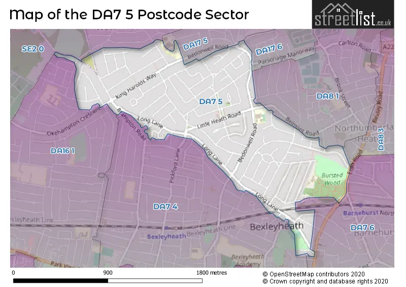
The DA7 5 Postcode shares a border with DA7 4 (BEXLEYHEATH ), DA8 1 (ERITH ), DA16 1 (WELLING ), DA17 5 (BELVEDERE ), DA17 6 (BELVEDERE ), SE2 0 (ABBEY WOOD , LONDON , PLUMSTEAD ), DA7 6 (BEXLEYHEATH ) and DA8 3 (ERITH ).
Map of the DA7 5 Postcode Sector
Explore the DA7 5 postcode sector by using our interactive map.
The sector is within the post town of BEXLEYHEATH.
DA7 5 is a postcode sector within the DA7 postcode district which is within the DA Dartford postcode area.
The Royal Mail delivery office for the DA7 5 postal sector is the Bexleyheath Delivery Office.
The area of the DA7 5 postcode sector is 0.83 square miles which is 2.15 square kilometres or 532.47 square acres.
Your support helps keep this site running!
If you enjoy using this website, consider buying me a coffee to help cover hosting costs.


| D | A | 7 | - | 5 | X | X |
| D | A | 7 | Space | 5 | Letter | Letter |
Official List of Streets
BEXLEYHEATH (73 Streets)
Unofficial Streets or Alternative Spellings
BEXLEYHEATH
BELVEDERE ROAD FRANKLIN ROAD GRASMERE ROAD HASLEMERE ROAD HUDSON ROAD HYDE ROAD KIPLING ROAD PALMAR CRESCENT PICKFORD LANE WINDERMERE ROAD WOOLWICH ROADERITH
BELMONT ROAD DALMENY ROAD IGHTHAM ROAD FP39 FP40 STREAM WAYNorthumberland Heath
ERITH ROADBELVEDERE
DRYHILL ROAD NUXLEY ROAD PARSONAGE MANORWAYBexley
BEDONWELL ROADWELLING
HADLOW ROAD OKEHAMPTON CRESCENT PLYMSTOCK ROADWeather Forecast for DA7 5
Weather Forecast for Bexley
| Time Period | Icon | Description | Temperature | Rain Probability | Wind |
|---|---|---|---|---|---|
| 21:00 to 00:00 | Light rain | 11.0°C (feels like 10.0°C) | 51.00% | SSW 9 mph |
| Time Period | Icon | Description | Temperature | Rain Probability | Wind |
|---|---|---|---|---|---|
| 00:00 to 03:00 | Light rain | 11.0°C (feels like 9.0°C) | 54.00% | SSW 7 mph | |
| 03:00 to 06:00 | Light rain | 10.0°C (feels like 9.0°C) | 52.00% | SSW 4 mph | |
| 06:00 to 09:00 | Light rain | 10.0°C (feels like 9.0°C) | 54.00% | SW 4 mph | |
| 09:00 to 12:00 | Cloudy | 10.0°C (feels like 9.0°C) | 16.00% | WSW 7 mph | |
| 12:00 to 15:00 | Cloudy | 11.0°C (feels like 10.0°C) | 9.00% | WSW 9 mph | |
| 15:00 to 18:00 | Cloudy | 12.0°C (feels like 11.0°C) | 8.00% | WSW 9 mph | |
| 18:00 to 21:00 | Clear night | 10.0°C (feels like 9.0°C) | 6.00% | SW 7 mph | |
| 21:00 to 00:00 | Clear night | 9.0°C (feels like 7.0°C) | 0.00% | SW 7 mph |
| Time Period | Icon | Description | Temperature | Rain Probability | Wind |
|---|---|---|---|---|---|
| 00:00 to 03:00 | Partly cloudy (night) | 8.0°C (feels like 5.0°C) | 3.00% | SW 7 mph | |
| 03:00 to 06:00 | Cloudy | 8.0°C (feels like 5.0°C) | 6.00% | SSW 9 mph | |
| 06:00 to 09:00 | Cloudy | 8.0°C (feels like 5.0°C) | 5.00% | SSW 9 mph | |
| 09:00 to 12:00 | Cloudy | 9.0°C (feels like 6.0°C) | 5.00% | SSW 13 mph | |
| 12:00 to 15:00 | Cloudy | 11.0°C (feels like 8.0°C) | 5.00% | SSW 16 mph | |
| 15:00 to 18:00 | Cloudy | 11.0°C (feels like 8.0°C) | 10.00% | SSW 18 mph | |
| 18:00 to 21:00 | Light rain | 10.0°C (feels like 7.0°C) | 51.00% | SSW 20 mph | |
| 21:00 to 00:00 | Heavy rain | 10.0°C (feels like 7.0°C) | 80.00% | SSW 20 mph |
| Time Period | Icon | Description | Temperature | Rain Probability | Wind |
|---|---|---|---|---|---|
| 00:00 to 03:00 | Heavy rain | 10.0°C (feels like 7.0°C) | 85.00% | SSW 16 mph | |
| 03:00 to 06:00 | Heavy rain | 10.0°C (feels like 7.0°C) | 81.00% | SSW 13 mph | |
| 06:00 to 09:00 | Cloudy | 10.0°C (feels like 7.0°C) | 24.00% | SW 11 mph | |
| 09:00 to 12:00 | Cloudy | 10.0°C (feels like 8.0°C) | 19.00% | SW 11 mph | |
| 12:00 to 15:00 | Light rain shower (day) | 12.0°C (feels like 9.0°C) | 40.00% | SW 11 mph | |
| 15:00 to 18:00 | Cloudy | 12.0°C (feels like 10.0°C) | 25.00% | WSW 9 mph | |
| 18:00 to 21:00 | Partly cloudy (night) | 10.0°C (feels like 8.0°C) | 13.00% | SW 7 mph | |
| 21:00 to 00:00 | Clear night | 9.0°C (feels like 7.0°C) | 10.00% | SW 7 mph |
| Time Period | Icon | Description | Temperature | Rain Probability | Wind |
|---|---|---|---|---|---|
| 00:00 to 03:00 | Clear night | 8.0°C (feels like 6.0°C) | 10.00% | SW 7 mph | |
| 03:00 to 06:00 | Clear night | 7.0°C (feels like 5.0°C) | 10.00% | SW 7 mph | |
| 06:00 to 09:00 | Partly cloudy (night) | 6.0°C (feels like 4.0°C) | 11.00% | SW 7 mph | |
| 09:00 to 12:00 | Partly cloudy (day) | 7.0°C (feels like 4.0°C) | 12.00% | WSW 9 mph | |
| 12:00 to 15:00 | Partly cloudy (day) | 9.0°C (feels like 7.0°C) | 11.00% | W 9 mph | |
| 15:00 to 18:00 | Partly cloudy (day) | 10.0°C (feels like 8.0°C) | 34.00% | W 9 mph | |
| 18:00 to 21:00 | Partly cloudy (night) | 9.0°C (feels like 7.0°C) | 12.00% | WSW 7 mph | |
| 21:00 to 00:00 | Clear night | 7.0°C (feels like 5.0°C) | 8.00% | WSW 7 mph |
Schools and Places of Education Within the DA7 5 Postcode Sector
Bursted Wood Primary School
Academy converter
Swanbridge Road, Bexleyheath, Kent, DA7 5BS
Head: Miss Helen Charman
Ofsted Rating: Good
Inspection: 2021-11-12 (1197 days ago)
Website: Visit Bursted Wood Primary School Website
Phone: 02083049960
Number of Pupils: 616
House Prices in the DA7 5 Postcode Sector
| Type of Property | 2018 Average | 2018 Sales | 2017 Average | 2017 Sales | 2016 Average | 2016 Sales | 2015 Average | 2015 Sales |
|---|---|---|---|---|---|---|---|---|
| Detached | £454,125 | 8 | £499,583 | 12 | £493,800 | 10 | £392,222 | 9 |
| Semi-Detached | £439,508 | 101 | £430,899 | 87 | £414,033 | 108 | £351,899 | 105 |
| Terraced | £403,954 | 33 | £392,367 | 30 | £398,081 | 37 | £354,973 | 45 |
| Flats | £220,667 | 3 | £202,500 | 2 | £245,750 | 2 | £336,640 | 10 |
Important Postcodes DA7 5 in the Postcode Sector
DA7 5BS is the postcode for Bursted Wood Primary School, Swanbridge Road
DA7 5RB is the postcode for Doctors Surgery, 171 King Harolds Way
| The DA7 5 Sector is within these Local Authorities |
|
|---|---|
| The DA7 5 Sector is within these Counties |
|
| The DA7 5 Sector is within these Water Company Areas |
|