A wide range of spatial data has been analysed to present this overview of the DA12 5 Postcode sector. If you would like anything added, please contact us.
The DA12 5 postcode sector is within the county of Kent.
Did you know? According to the 2021 Census, the DA12 5 postcode sector is home to a bustling 15,945 residents!
Given that each sector allows for 400 unique postcode combinations. Letters C, I, K, M, O and V are not allowed in the last two letters of a postcode. With 238 postcodes already in use, this leaves 162 units available.
The DA12 5 postal code covers the settlement of GRAVESEND.
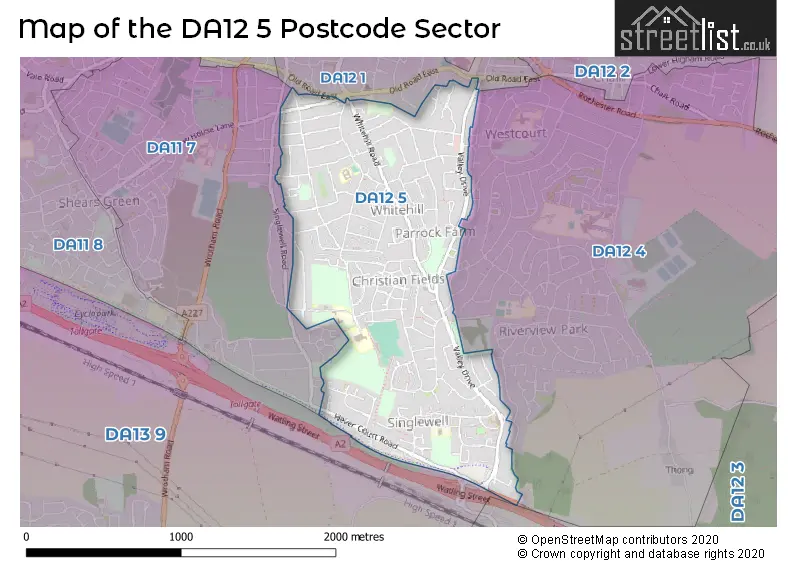
The DA12 5 Postcode shares a border with DA11 7 (GRAVESEND, Northfleet), DA13 9 (Istead Rise, Southfleet, Cobham), DA12 1 (GRAVESEND), DA12 3 (Shorne, Cobham) and DA12 4 (GRAVESEND).
Map of the DA12 5 Postcode Sector
Explore the DA12 5 postcode sector by using our interactive map.
The sector is within the post town of GRAVESEND.
DA12 5 is a postcode sector within the DA12 postcode district which is within the DA Dartford postcode area.
The Royal Mail delivery office for the DA12 5 postal sector is the Gravesend Delivery Office.
The area of the DA12 5 postcode sector is 1.03 square miles which is 2.67 square kilometres or 660.58 square acres.
The DA12 5 postcode sector is crossed by the A2 Major A road.
Your support helps keep this site running!
If you enjoy using this website, consider buying me a coffee to help cover hosting costs.


| D | A | 1 | 2 | - | 5 | X | X |
| D | A | 1 | 2 | Space | 5 | Letter | Letter |
Official List of Streets
GRAVESEND (115 Streets)
Unofficial Streets or Alternative Spellings
GRAVESEND
LORTON CLOSE MARLING WAY OLD ROAD EAST SINGLEWELL ROAD THE WARREN DAVYS PLACE LOWER THAMES CROSSING (ROADS SOUTH) PEGASUS COURT ST AIDANS WAY ST BENEDICTS AVENUE ST DAVIDS CRESCENT ST GEORGES CRESCENT ST HILDAS WAY ST PATRICKS GARDENS THE PARADE TURNER HOUSE VIRGINIA PATHWAY WIMBORNE HOUSEBean
WATLING STREETShorne
WATLING STREETWeather Forecast for DA12 5
Weather Forecast for Gravesend
| Time Period | Icon | Description | Temperature | Rain Probability | Wind |
|---|---|---|---|---|---|
| 15:00 to 18:00 | Overcast | 7.0°C (feels like 4.0°C) | 7.00% | S 7 mph | |
| 18:00 to 21:00 | Clear night | 4.0°C (feels like 2.0°C) | 1.00% | SSE 7 mph | |
| 21:00 to 00:00 | Clear night | 3.0°C (feels like 0.0°C) | 0.00% | SE 4 mph |
| Time Period | Icon | Description | Temperature | Rain Probability | Wind |
|---|---|---|---|---|---|
| 00:00 to 03:00 | Clear night | 2.0°C (feels like 0.0°C) | 0.00% | SE 4 mph | |
| 03:00 to 06:00 | Clear night | 1.0°C (feels like -1.0°C) | 1.00% | SE 4 mph | |
| 06:00 to 09:00 | Clear night | 0.0°C (feels like -2.0°C) | 1.00% | SE 4 mph | |
| 09:00 to 12:00 | Sunny day | 2.0°C (feels like -1.0°C) | 1.00% | SE 4 mph | |
| 12:00 to 15:00 | Sunny day | 6.0°C (feels like 4.0°C) | 0.00% | SSE 4 mph | |
| 15:00 to 18:00 | Sunny day | 6.0°C (feels like 5.0°C) | 0.00% | SSE 4 mph | |
| 18:00 to 21:00 | Clear night | 3.0°C (feels like 1.0°C) | 0.00% | S 4 mph | |
| 21:00 to 00:00 | Clear night | 2.0°C (feels like 0.0°C) | 1.00% | S 4 mph |
| Time Period | Icon | Description | Temperature | Rain Probability | Wind |
|---|---|---|---|---|---|
| 00:00 to 03:00 | Clear night | 1.0°C (feels like -2.0°C) | 2.00% | SSW 4 mph | |
| 03:00 to 06:00 | Clear night | 0.0°C (feels like -2.0°C) | 4.00% | SSW 4 mph | |
| 06:00 to 09:00 | Cloudy | 0.0°C (feels like -2.0°C) | 7.00% | SW 4 mph | |
| 09:00 to 12:00 | Overcast | 2.0°C (feels like 0.0°C) | 9.00% | SSW 4 mph | |
| 12:00 to 15:00 | Cloudy | 6.0°C (feels like 4.0°C) | 5.00% | SSW 7 mph | |
| 15:00 to 18:00 | Partly cloudy (day) | 8.0°C (feels like 6.0°C) | 2.00% | SSW 7 mph | |
| 18:00 to 21:00 | Clear night | 5.0°C (feels like 2.0°C) | 2.00% | S 7 mph | |
| 21:00 to 00:00 | Clear night | 4.0°C (feels like 1.0°C) | 1.00% | SSW 7 mph |
| Time Period | Icon | Description | Temperature | Rain Probability | Wind |
|---|---|---|---|---|---|
| 00:00 to 03:00 | Cloudy | 3.0°C (feels like 1.0°C) | 5.00% | SSW 7 mph | |
| 03:00 to 06:00 | Clear night | 4.0°C (feels like 1.0°C) | 2.00% | SSW 7 mph | |
| 06:00 to 09:00 | Clear night | 4.0°C (feels like 1.0°C) | 1.00% | SSW 7 mph | |
| 09:00 to 12:00 | Sunny day | 5.0°C (feels like 2.0°C) | 2.00% | SSW 9 mph | |
| 12:00 to 15:00 | Partly cloudy (day) | 9.0°C (feels like 6.0°C) | 3.00% | SSW 11 mph | |
| 15:00 to 18:00 | Cloudy | 10.0°C (feels like 7.0°C) | 6.00% | SSW 11 mph | |
| 18:00 to 21:00 | Overcast | 8.0°C (feels like 6.0°C) | 15.00% | SSW 11 mph | |
| 21:00 to 00:00 | Overcast | 8.0°C (feels like 6.0°C) | 16.00% | SW 9 mph |
| Time Period | Icon | Description | Temperature | Rain Probability | Wind |
|---|---|---|---|---|---|
| 00:00 to 03:00 | Clear night | 7.0°C (feels like 5.0°C) | 7.00% | WSW 7 mph | |
| 03:00 to 06:00 | Clear night | 6.0°C (feels like 3.0°C) | 4.00% | W 7 mph | |
| 06:00 to 09:00 | Clear night | 4.0°C (feels like 2.0°C) | 3.00% | WNW 7 mph | |
| 09:00 to 12:00 | Partly cloudy (day) | 4.0°C (feels like 2.0°C) | 2.00% | NW 7 mph | |
| 12:00 to 15:00 | Cloudy | 7.0°C (feels like 5.0°C) | 4.00% | NW 7 mph | |
| 15:00 to 18:00 | Cloudy | 8.0°C (feels like 6.0°C) | 5.00% | N 7 mph | |
| 18:00 to 21:00 | Cloudy | 5.0°C (feels like 4.0°C) | 5.00% | N 4 mph | |
| 21:00 to 00:00 | Cloudy | 5.0°C (feels like 3.0°C) | 4.00% | N 4 mph |
Schools and Places of Education Within the DA12 5 Postcode Sector
Ifield School
Foundation special school
Cedar Avenue, Gravesend, Kent, DA12 5JT
Head: Mrs Madeleine Arnold-Jones
Ofsted Rating: Outstanding
Inspection: 2023-11-02 (457 days ago)
Website: Visit Ifield School Website
Phone: 01474365485
Number of Pupils: 265
King's Farm Primary School
Community school
Cedar Avenue, Gravesend, Kent, DA12 5JT
Head: Mr Chris Jackson
Ofsted Rating: Good
Inspection: 2018-05-23 (2446 days ago)
Website: Visit King's Farm Primary School Website
Phone: 01474566979
Number of Pupils: 437
Singlewell Primary School
Community school
Mackenzie Way, Gravesend, Kent, DA12 5TY
Head: Mrs Michelle Brown
Ofsted Rating: Good
Inspection: 2023-01-25 (738 days ago)
Website: Visit Singlewell Primary School Website
Phone: 01474569859
Number of Pupils: 392
Whitehill Primary School
Academy converter
Sun Lane, Gravesend, Kent, DA12 5HN
Head: Mrs Angela Carpenter
Ofsted Rating: Requires improvement
Inspection: 2022-03-24 (1045 days ago)
Website: Visit Whitehill Primary School Website
Phone: 01474352973
Number of Pupils: 659
House Prices in the DA12 5 Postcode Sector
| Type of Property | 2018 Average | 2018 Sales | 2017 Average | 2017 Sales | 2016 Average | 2016 Sales | 2015 Average | 2015 Sales |
|---|---|---|---|---|---|---|---|---|
| Detached | £524,583 | 18 | £447,000 | 19 | £408,928 | 14 | £397,674 | 23 |
| Semi-Detached | £306,360 | 50 | £310,331 | 55 | £293,730 | 52 | £255,445 | 42 |
| Terraced | £280,806 | 126 | £273,014 | 105 | £262,163 | 115 | £220,187 | 141 |
| Flats | £174,425 | 10 | £181,233 | 15 | £152,429 | 21 | £135,895 | 12 |
Important Postcodes DA12 5 in the Postcode Sector
DA12 5BW is the postcode for The Lighthouse Centre, Kings Farm Family Centre, and Oakfield Medical Centre, Windsor Road
DA12 5HN is the postcode for Juniors, Whitehill Primary School, Sun Lane, INFANTS, Whitehill Primary School, Sun Lane, and Whitehill Primary School, Sun Lane
DA12 5HS is the postcode for Surestart, Next Steps Childrens Centre, Cornwell Avenue
DA12 5JT is the postcode for IFIELD SMILE CENTRE, Ifield School, Cedar Avenue, Kings Farm Primary School, Cedar Avenue, IFIELD SCHOOL, CEDAR AVENUE, GRAVESEND, and Ifield School, Cedar Avenue
DA12 5TY is the postcode for Singlewell Cp School, Mackenzie Way
| The DA12 5 Sector is within these Local Authorities |
|
|---|---|
| The DA12 5 Sector is within these Counties |
|
| The DA12 5 Sector is within these Water Company Areas |
|