A wide range of spatial data has been analysed to present this overview of the DA1 3 Postcode sector. If you would like anything added, please contact us.
The DA1 3 postcode sector stands on the Greater London and Kent border.
Did you know? According to the 2021 Census, the DA1 3 postcode sector is home to a bustling 11,793 residents!
Given that each sector allows for 400 unique postcode combinations. Letters C, I, K, M, O and V are not allowed in the last two letters of a postcode. With 181 postcodes already in use, this leaves 219 units available.
The largest settlements in the DA1 3 postal code are DARTFORD and CRAYFORD .
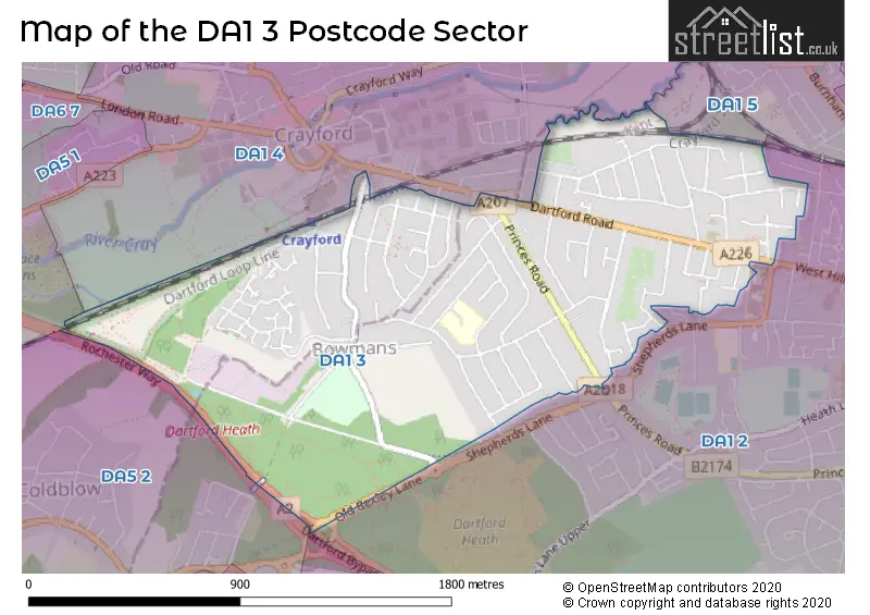
The DA1 3 Postcode shares a border with DA1 4 (CRAYFORD ), DA1 5 (DARTFORD ), DA2 7 (WILMINGTON, DARENTH, HAWLEY), DA5 1 (BEXLEY ), DA5 2 (BEXLEY ) and DA1 2 (DARTFORD , WILMINGTON ).
Map of the DA1 3 Postcode Sector
Explore the DA1 3 postcode sector by using our interactive map.
The sector is within the post town of DARTFORD.
DA1 3 is a postcode sector within the DA1 postcode district which is within the DA Dartford postcode area.
The Royal Mail delivery office for the DA1 3 postal sector is the Dartford Delivery Office.
The area of the DA1 3 postcode sector is 1.03 square miles which is 2.67 square kilometres or 660.83 square acres.
The DA1 3 postcode sector is crossed by the A2 Major A road.
Your support helps keep this site running!
If you enjoy using this website, consider buying me a coffee to help cover hosting costs.


| D | A | 1 | - | 3 | X | X |
| D | A | 1 | Space | 3 | Letter | Letter |
Official List of Streets
Crayford (34 Streets)
DARTFORD (60 Streets)
Unofficial Streets or Alternative Spellings
DARTFORD
SHEPHERDS LANE WEST HILLCrayford
CRAYFORD ROAD MAIDEN LANE DENTON ROAD FP124 FP125BEXLEY
OLD BEXLEY LANEWeather Forecast for DA1 3
Weather Forecast for Dartford
| Time Period | Icon | Description | Temperature | Rain Probability | Wind |
|---|---|---|---|---|---|
| 06:00 to 09:00 | Light rain | 4.0°C (feels like 1.0°C) | 56.00% | SSW 7 mph | |
| 09:00 to 12:00 | Heavy rain | 5.0°C (feels like 2.0°C) | 76.00% | S 9 mph | |
| 12:00 to 15:00 | Overcast | 6.0°C (feels like 4.0°C) | 41.00% | SW 7 mph | |
| 15:00 to 18:00 | Overcast | 7.0°C (feels like 5.0°C) | 10.00% | ESE 4 mph | |
| 18:00 to 21:00 | Overcast | 6.0°C (feels like 4.0°C) | 8.00% | SE 4 mph | |
| 21:00 to 00:00 | Overcast | 5.0°C (feels like 4.0°C) | 8.00% | SSE 4 mph |
| Time Period | Icon | Description | Temperature | Rain Probability | Wind |
|---|---|---|---|---|---|
| 00:00 to 03:00 | Cloudy | 4.0°C (feels like 2.0°C) | 5.00% | SSE 4 mph | |
| 03:00 to 06:00 | Cloudy | 3.0°C (feels like 2.0°C) | 5.00% | SSE 2 mph | |
| 06:00 to 09:00 | Cloudy | 2.0°C (feels like 0.0°C) | 6.00% | SSE 4 mph | |
| 09:00 to 12:00 | Partly cloudy (day) | 3.0°C (feels like 1.0°C) | 3.00% | SSE 4 mph | |
| 12:00 to 15:00 | Partly cloudy (day) | 6.0°C (feels like 4.0°C) | 2.00% | SSE 7 mph | |
| 15:00 to 18:00 | Partly cloudy (day) | 7.0°C (feels like 5.0°C) | 2.00% | SSE 7 mph | |
| 18:00 to 21:00 | Clear night | 4.0°C (feels like 2.0°C) | 1.00% | SSE 7 mph | |
| 21:00 to 00:00 | Partly cloudy (night) | 3.0°C (feels like 1.0°C) | 1.00% | SSE 4 mph |
| Time Period | Icon | Description | Temperature | Rain Probability | Wind |
|---|---|---|---|---|---|
| 00:00 to 03:00 | Partly cloudy (night) | 3.0°C (feels like 0.0°C) | 2.00% | SSE 7 mph | |
| 03:00 to 06:00 | Cloudy | 2.0°C (feels like -1.0°C) | 5.00% | SSE 7 mph | |
| 06:00 to 09:00 | Cloudy | 2.0°C (feels like -1.0°C) | 6.00% | SSE 7 mph | |
| 09:00 to 12:00 | Cloudy | 3.0°C (feels like 0.0°C) | 10.00% | SSE 7 mph | |
| 12:00 to 15:00 | Sunny day | 6.0°C (feels like 4.0°C) | 8.00% | S 7 mph | |
| 15:00 to 18:00 | Sunny day | 7.0°C (feels like 5.0°C) | 8.00% | SSW 4 mph | |
| 18:00 to 21:00 | Clear night | 5.0°C (feels like 3.0°C) | 5.00% | SSW 4 mph | |
| 21:00 to 00:00 | Clear night | 3.0°C (feels like 2.0°C) | 5.00% | SSW 4 mph |
| Time Period | Icon | Description | Temperature | Rain Probability | Wind |
|---|---|---|---|---|---|
| 00:00 to 03:00 | Clear night | 3.0°C (feels like 1.0°C) | 4.00% | SSW 4 mph | |
| 03:00 to 06:00 | Partly cloudy (night) | 2.0°C (feels like 0.0°C) | 4.00% | SSW 4 mph | |
| 06:00 to 09:00 | Cloudy | 2.0°C (feels like 0.0°C) | 6.00% | SW 4 mph | |
| 09:00 to 12:00 | Mist | 3.0°C (feels like 1.0°C) | 14.00% | SSW 4 mph | |
| 12:00 to 15:00 | Cloudy | 6.0°C (feels like 4.0°C) | 5.00% | S 7 mph | |
| 15:00 to 18:00 | Cloudy | 7.0°C (feels like 5.0°C) | 5.00% | SSW 7 mph | |
| 18:00 to 21:00 | Partly cloudy (night) | 6.0°C (feels like 3.0°C) | 2.00% | S 7 mph | |
| 21:00 to 00:00 | Cloudy | 5.0°C (feels like 2.0°C) | 5.00% | S 7 mph |
Schools and Places of Education Within the DA1 3 Postcode Sector
Wentworth Primary School
Academy converter
Wentworth Drive, Dartford, Kent, DA1 3NG
Head: Mr Lewis Pollock
Ofsted Rating: Good
Inspection: 2023-06-08 (603 days ago)
Website: Visit Wentworth Primary School Website
Phone: 01322225694
Number of Pupils: 651
West Hill Primary Academy
Academy converter
Dartford Road, Dartford, Kent, DA1 3DZ
Head: Ms Katy Ward
Ofsted Rating: Good
Inspection: 2021-10-01 (1218 days ago)
Website: Visit West Hill Primary Academy Website
Phone: 01322226019
Number of Pupils: 534
House Prices in the DA1 3 Postcode Sector
| Type of Property | 2018 Average | 2018 Sales | 2017 Average | 2017 Sales | 2016 Average | 2016 Sales | 2015 Average | 2015 Sales |
|---|---|---|---|---|---|---|---|---|
| Detached | £590,313 | 8 | £475,485 | 18 | £464,934 | 19 | £420,200 | 15 |
| Semi-Detached | £379,342 | 68 | £380,558 | 67 | £363,309 | 77 | £338,365 | 65 |
| Terraced | £318,516 | 72 | £320,336 | 67 | £297,075 | 70 | £265,955 | 59 |
| Flats | £227,900 | 10 | £220,464 | 14 | £198,115 | 17 | £171,525 | 20 |
Important Postcodes DA1 3 in the Postcode Sector
DA1 3DZ is the postcode for CANTEEN BLOCK, West Hill Primary Academy, Dartford Road, and West Hill Primary Academy, Dartford Road
DA1 3NG is the postcode for NEW CLASSROOM BLOCK, Wentworth Primary School, Wentworth Drive, Wentworth Primary School, Wentworth Drive, Wentworth County Infant School, Wentworth Drive, and WENTWORTH COUNTY PRIMARY SCHOOL, WENTWORTH DRIVE, DARTFORD
| The DA1 3 Sector is within these Local Authorities |
|
|---|---|
| The DA1 3 Sector is within these Counties |
|
| The DA1 3 Sector is within these Water Company Areas |
|