A wide range of spatial data has been analysed to present this overview of the CV7 8 Postcode sector. If you would like anything added, please contact us.
The CV7 8 postcode sector stands on the Warwickshire and West Midlands border.
Did you know? According to the 2021 Census, the CV7 8 postcode sector is home to a bustling 9,418 residents!
Given that each sector allows for 400 unique postcode combinations. Letters C, I, K, M, O and V are not allowed in the last two letters of a postcode. With 237 postcodes already in use, this leaves 163 units available.
The largest settlement in the CV7 8 postal code is Keresley End followed by Fillongley, and Arley.
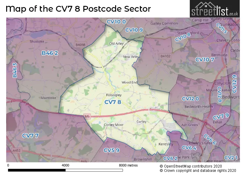
The CV7 8 Postcode shares a border with B46 2 (Coleshill, Furnace End), CV5 9 (COVENTRY, Allesley, Millisons Wood), CV6 4 (COVENTRY, Prologis Park), CV10 0 (NUNEATON, Hartshill, Ridge Lane), CV10 7 (NUNEATON, Astley, Bermuda Park), CV10 9 (NUNEATON, Galley Common, Ansley), CV12 0 (BEDWORTH), CV7 9 (Exhall, COVENTRY, Shilton), CV6 2 (COVENTRY) and CV7 7 (Balsall Common, Meriden, Berkswell).
Map of the CV7 8 Postcode Sector
Explore the CV7 8 postcode sector by using our interactive map.
The sector is within the post town of COVENTRY.
CV7 8 is a postcode sector within the CV7 postcode district which is within the CV Coventry postcode area.
The Royal Mail delivery office for the CV7 8 postal sector is the Coventry City Delivery Office and Fillongley Scale Payment Delivery Office and Gun Hill Scale Payment Delivery Office and Keresley End Scale Payment Delivery Office.
The area of the CV7 8 postcode sector is 15.55 square miles which is 40.28 square kilometres or 9,953.24 square acres.
The CV7 8 postcode sector is crossed by the M6 motorway.
Your support helps keep this site running!
If you enjoy using this website, consider buying me a coffee to help cover hosting costs.

| C | V | 7 | - | 8 | X | X |
| C | V | 7 | Space | 8 | Letter | Letter |
Official List of Streets
Keresley End (59 Streets)
Fillongley (35 Streets)
Arley (33 Streets)
Gun Hill (14 Streets)
(23 Streets)
Corley (24 Streets)
Unofficial Streets or Alternative Spellings
Ash Green
BLACKBERRY LANE NEW ROADPrologis Park
PILGRIMS WALKKeresley End
DE-COMPTON CLOSE QUEENSWOOD COURTCOVENTRY
BENNETTS ROAD SOUTHAllesley
BRIDLE BROOK LANE LONG LANE WALL HILL ROADBEDWORTH
SMORRALL LANEMeriden
FILLONGLEY ROADAstley
PARK LANEAnsley
ANSLEY LANEColeshill
DAW MILL LANE FILLONGLEY ROAD NEWTOWN LANE SHAWBURY LANEWeather Forecast for CV7 8
Weather Forecast for Forest Of Arden Golf & Country Club
| Time Period | Icon | Description | Temperature | Rain Probability | Wind |
|---|---|---|---|---|---|
| 00:00 to 03:00 | Cloudy | 4.0°C (feels like 1.0°C) | 8.00% | SSW 7 mph | |
| 03:00 to 06:00 | Overcast | 4.0°C (feels like 2.0°C) | 9.00% | SSW 7 mph | |
| 06:00 to 09:00 | Overcast | 5.0°C (feels like 2.0°C) | 10.00% | SSW 7 mph | |
| 09:00 to 12:00 | Overcast | 5.0°C (feels like 2.0°C) | 11.00% | SSW 9 mph | |
| 12:00 to 15:00 | Cloudy | 8.0°C (feels like 5.0°C) | 6.00% | SSW 11 mph | |
| 15:00 to 18:00 | Cloudy | 9.0°C (feels like 6.0°C) | 6.00% | SSW 11 mph | |
| 18:00 to 21:00 | Cloudy | 7.0°C (feels like 4.0°C) | 5.00% | S 9 mph | |
| 21:00 to 00:00 | Cloudy | 6.0°C (feels like 3.0°C) | 5.00% | SSW 11 mph |
| Time Period | Icon | Description | Temperature | Rain Probability | Wind |
|---|---|---|---|---|---|
| 00:00 to 03:00 | Cloudy | 6.0°C (feels like 2.0°C) | 5.00% | SSW 13 mph | |
| 03:00 to 06:00 | Cloudy | 6.0°C (feels like 2.0°C) | 5.00% | SSW 13 mph | |
| 06:00 to 09:00 | Cloudy | 7.0°C (feels like 3.0°C) | 5.00% | SSW 13 mph | |
| 09:00 to 12:00 | Overcast | 7.0°C (feels like 4.0°C) | 8.00% | SSW 16 mph | |
| 12:00 to 15:00 | Cloudy | 9.0°C (feels like 6.0°C) | 16.00% | SSW 16 mph | |
| 15:00 to 18:00 | Light rain | 9.0°C (feels like 6.0°C) | 63.00% | SSW 13 mph | |
| 18:00 to 21:00 | Heavy rain | 8.0°C (feels like 6.0°C) | 77.00% | SW 11 mph | |
| 21:00 to 00:00 | Clear night | 7.0°C (feels like 4.0°C) | 7.00% | WSW 11 mph |
| Time Period | Icon | Description | Temperature | Rain Probability | Wind |
|---|---|---|---|---|---|
| 00:00 to 03:00 | Clear night | 5.0°C (feels like 2.0°C) | 1.00% | WSW 9 mph | |
| 03:00 to 06:00 | Clear night | 4.0°C (feels like 1.0°C) | 1.00% | WSW 9 mph | |
| 06:00 to 09:00 | Clear night | 3.0°C (feels like 0.0°C) | 1.00% | WSW 7 mph | |
| 09:00 to 12:00 | Cloudy | 4.0°C (feels like 1.0°C) | 4.00% | WSW 7 mph | |
| 12:00 to 15:00 | Cloudy | 6.0°C (feels like 4.0°C) | 4.00% | W 7 mph | |
| 15:00 to 18:00 | Cloudy | 7.0°C (feels like 6.0°C) | 4.00% | WNW 7 mph | |
| 18:00 to 21:00 | Clear night | 4.0°C (feels like 3.0°C) | 1.00% | WNW 4 mph | |
| 21:00 to 00:00 | Clear night | 3.0°C (feels like 1.0°C) | 1.00% | NW 2 mph |
| Time Period | Icon | Description | Temperature | Rain Probability | Wind |
|---|---|---|---|---|---|
| 00:00 to 03:00 | Clear night | 1.0°C (feels like -1.0°C) | 1.00% | NW 2 mph | |
| 03:00 to 06:00 | Clear night | 0.0°C (feels like -2.0°C) | 2.00% | NNW 2 mph | |
| 06:00 to 09:00 | Clear night | 0.0°C (feels like -2.0°C) | 2.00% | NNE 4 mph | |
| 09:00 to 12:00 | Sunny day | 1.0°C (feels like -1.0°C) | 2.00% | N 4 mph | |
| 12:00 to 15:00 | Sunny day | 6.0°C (feels like 4.0°C) | 1.00% | ENE 4 mph | |
| 15:00 to 18:00 | Sunny day | 7.0°C (feels like 5.0°C) | 1.00% | E 7 mph | |
| 18:00 to 21:00 | Clear night | 4.0°C (feels like 1.0°C) | 0.00% | ENE 7 mph | |
| 21:00 to 00:00 | Clear night | 2.0°C (feels like -1.0°C) | 1.00% | ENE 7 mph |
Schools and Places of Education Within the CV7 8 Postcode Sector
Arc School Old Arley
Other independent special school
Ansley Lane, Nuneaton, Warwickshire, CV7 8NU
Head: Mr Philip Petch
Ofsted Rating: Requires improvement
Inspection: 2022-07-14 (934 days ago)
Website: Visit Arc School Old Arley Website
Phone: 01676543200
Number of Pupils: 62
Bournebrook CofE Primary School
Voluntary controlled school
Coventry Road, Coventry, West Midlands, CV7 8ET
Head: Mrs Nicola Smith
Ofsted Rating: Good
Inspection: 2019-11-13 (1908 days ago)
Website: Visit Bournebrook CofE Primary School Website
Phone: 01676540390
Number of Pupils: 130
Keresley Newland Primary Academy
Academy sponsor led
Grove Lane, Coventry, Warwickshire, CV7 8JZ
Head: Mrs Nicola Penlington
Ofsted Rating: Good
Inspection: 2023-05-05 (639 days ago)
Website: Visit Keresley Newland Primary Academy Website
Phone: 02476332434
Number of Pupils: 162
House Prices in the CV7 8 Postcode Sector
| Type of Property | 2018 Average | 2018 Sales | 2017 Average | 2017 Sales | 2016 Average | 2016 Sales | 2015 Average | 2015 Sales |
|---|---|---|---|---|---|---|---|---|
| Detached | £411,975 | 62 | £382,204 | 48 | £351,803 | 49 | £286,014 | 44 |
| Semi-Detached | £184,524 | 58 | £174,408 | 37 | £151,111 | 57 | £154,485 | 74 |
| Terraced | £136,178 | 58 | £145,082 | 48 | £117,723 | 60 | £110,808 | 51 |
| Flats | £108,667 | 3 | £114,667 | 3 | £109,125 | 4 | £99,000 | 1 |
Important Postcodes CV7 8 in the Postcode Sector
CV7 8AZ is the postcode for Corley Centre, Church Lane, and Corley Centre, Church Lane, Corley
CV7 8ET is the postcode for Warwickshire County Council, Bournebrook School, Coventry Road
CV7 8FD is the postcode for SPRINGHILL MEDICAL CENTRE, PHIL COLLINS WAY
CV7 8FN is the postcode for Arley Sports Centre, Oak Avenue
CV7 8HB is the postcode for ARLEY PRIMARY SCHOOL, GUN HILL, ARLEY, and Arley Primary School, Gun Hill
CV7 8JZ is the postcode for Keresley Newland Primary School, Grove Lane
CV7 8NU is the postcode for MAIN BUILDING, Herbert Fowler Junior School, Ansley Lane
| The CV7 8 Sector is within these Local Authorities |
|
|---|---|
| The CV7 8 Sector is within these Counties |
|
| The CV7 8 Sector is within these Water Company Areas |
|