A wide range of spatial data has been analysed to present this overview of the CV10 0 Postcode sector. If you would like anything added, please contact us.
The CV10 0 postcode sector stands on the Leicestershire and Warwickshire border.
Did you know? According to the 2021 Census, the CV10 0 postcode sector is home to a bustling 15,743 residents!
Given that each sector allows for 400 unique postcode combinations. Letters C, I, K, M, O and V are not allowed in the last two letters of a postcode. With 315 postcodes already in use, this leaves 85 units available.
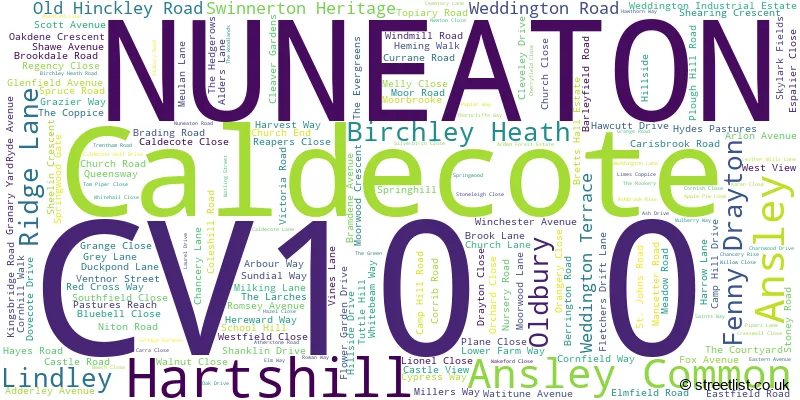
The largest settlement in the CV10 0 postal code is NUNEATON followed by Hartshill, and Ridge Lane.
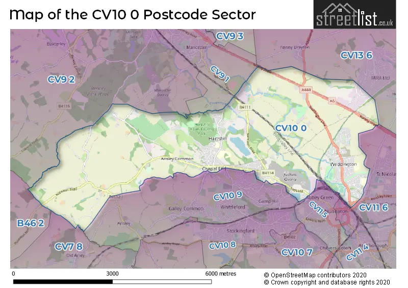
The CV10 0 Postcode shares a border with B46 2 (Coleshill, Furnace End), CV9 1 (ATHERSTONE, Mancetter), CV9 2 (Grendon, ATHERSTONE, Hurley), CV10 9 (NUNEATON, Galley Common, Ansley), CV11 4 (NUNEATON, Attleborough), CV11 6 (NUNEATON, Attleborough Fields Ind Estate, Bramcote), CV13 6 (Stoke Golding, Higham-on-the-Hill, Fenny Drayton), CV7 8 (Keresley End, Fillongley, Arley) and CV11 5 (NUNEATON, Coton).
Map of the CV10 0 Postcode Sector
Explore the CV10 0 postcode sector by using our interactive map.
The sector is within the post town of NUNEATON.
CV10 0 is a postcode sector within the CV10 postcode district which is within the CV Coventry postcode area.
The Royal Mail delivery office for the CV10 0 postal sector is the Nuneaton Delivery Office.
The area of the CV10 0 postcode sector is 10.35 square miles which is 26.81 square kilometres or 6,625.05 square acres.
The CV10 0 postcode sector is crossed by the A5 Major A road.
Waterways within the CV10 0 postcode sector include the Coventry Canal.
Your support helps keep this site running!
If you enjoy using this website, consider buying me a coffee to help cover hosting costs.


| C | V | 1 | 0 | - | 0 | X | X |
| C | V | 1 | 0 | Space | 0 | Letter | Letter |
Official List of Streets
NUNEATON (122 Streets)
Hartshill (38 Streets)
Ridge Lane (4 Streets)
(15 Streets)
Fenny Drayton (1 Streets)
Birchley Heath (2 Streets)
Caldecote (4 Streets)
Ansley (1 Streets)
Ansley Common (2 Streets)
Lindley (2 Streets)
Oldbury (1 Streets)
Unofficial Streets or Alternative Spellings
NUNEATON
BUCKS HILL CEDAR ROAD CHASE CLOSE CHAYTOR DRIVE CRADDOCK DRIVE GREEN LANE LILLEBURNE DRIVE MIDLAND ROAD QUEEN ELIZABETH ROADBurbage
WATLING STREETHigham-on-the-Hill
WOOD LANEMancetter
MONKS PARK LANE NUNEATON ROAD PURLEY CHASE LANEAnsley
BIRMINGHAM ROADArley
WOOD LANEColeshill
NUNEATON ROADWeather Forecast for CV10 0
Weather Forecast for Nuneaton
| Time Period | Icon | Description | Temperature | Rain Probability | Wind |
|---|---|---|---|---|---|
| 18:00 to 21:00 | Overcast | 6.0°C (feels like 3.0°C) | 9.00% | SSE 9 mph | |
| 21:00 to 00:00 | Overcast | 5.0°C (feels like 2.0°C) | 10.00% | SSE 11 mph |
| Time Period | Icon | Description | Temperature | Rain Probability | Wind |
|---|---|---|---|---|---|
| 00:00 to 03:00 | Overcast | 4.0°C (feels like 1.0°C) | 9.00% | S 11 mph | |
| 03:00 to 06:00 | Overcast | 4.0°C (feels like 0.0°C) | 8.00% | S 11 mph | |
| 06:00 to 09:00 | Overcast | 3.0°C (feels like 0.0°C) | 8.00% | SSE 9 mph | |
| 09:00 to 12:00 | Cloudy | 3.0°C (feels like 0.0°C) | 4.00% | S 7 mph | |
| 12:00 to 15:00 | Partly cloudy (day) | 6.0°C (feels like 2.0°C) | 1.00% | S 9 mph | |
| 15:00 to 18:00 | Partly cloudy (day) | 7.0°C (feels like 4.0°C) | 1.00% | SSW 9 mph | |
| 18:00 to 21:00 | Cloudy | 5.0°C (feels like 3.0°C) | 4.00% | SSW 4 mph | |
| 21:00 to 00:00 | Cloudy | 4.0°C (feels like 1.0°C) | 4.00% | S 7 mph |
| Time Period | Icon | Description | Temperature | Rain Probability | Wind |
|---|---|---|---|---|---|
| 00:00 to 03:00 | Overcast | 4.0°C (feels like 1.0°C) | 8.00% | SSW 7 mph | |
| 03:00 to 06:00 | Overcast | 4.0°C (feels like 1.0°C) | 8.00% | SSW 7 mph | |
| 06:00 to 09:00 | Overcast | 4.0°C (feels like 1.0°C) | 9.00% | SSW 7 mph | |
| 09:00 to 12:00 | Overcast | 4.0°C (feels like 1.0°C) | 8.00% | SSW 9 mph | |
| 12:00 to 15:00 | Overcast | 7.0°C (feels like 4.0°C) | 8.00% | SSW 11 mph | |
| 15:00 to 18:00 | Cloudy | 8.0°C (feels like 6.0°C) | 5.00% | SSW 9 mph | |
| 18:00 to 21:00 | Overcast | 7.0°C (feels like 4.0°C) | 7.00% | S 9 mph | |
| 21:00 to 00:00 | Cloudy | 7.0°C (feels like 3.0°C) | 5.00% | SSW 11 mph |
| Time Period | Icon | Description | Temperature | Rain Probability | Wind |
|---|---|---|---|---|---|
| 00:00 to 03:00 | Cloudy | 6.0°C (feels like 3.0°C) | 5.00% | SSW 11 mph | |
| 03:00 to 06:00 | Overcast | 7.0°C (feels like 3.0°C) | 8.00% | SSW 11 mph | |
| 06:00 to 09:00 | Partly cloudy (night) | 6.0°C (feels like 3.0°C) | 2.00% | SSW 13 mph | |
| 09:00 to 12:00 | Cloudy | 7.0°C (feels like 4.0°C) | 6.00% | SSW 13 mph | |
| 12:00 to 15:00 | Overcast | 10.0°C (feels like 7.0°C) | 16.00% | SSW 16 mph | |
| 15:00 to 18:00 | Light rain | 10.0°C (feels like 7.0°C) | 55.00% | SSW 13 mph | |
| 18:00 to 21:00 | Light rain | 9.0°C (feels like 6.0°C) | 50.00% | SW 9 mph | |
| 21:00 to 00:00 | Clear night | 7.0°C (feels like 4.0°C) | 8.00% | WSW 9 mph |
| Time Period | Icon | Description | Temperature | Rain Probability | Wind |
|---|---|---|---|---|---|
| 00:00 to 03:00 | Clear night | 5.0°C (feels like 3.0°C) | 4.00% | WSW 9 mph | |
| 03:00 to 06:00 | Clear night | 4.0°C (feels like 1.0°C) | 1.00% | W 7 mph | |
| 06:00 to 09:00 | Clear night | 2.0°C (feels like 0.0°C) | 2.00% | W 7 mph | |
| 09:00 to 12:00 | Cloudy | 3.0°C (feels like 1.0°C) | 4.00% | W 4 mph | |
| 12:00 to 15:00 | Cloudy | 6.0°C (feels like 5.0°C) | 4.00% | WNW 4 mph | |
| 15:00 to 18:00 | Cloudy | 7.0°C (feels like 6.0°C) | 4.00% | WNW 4 mph | |
| 18:00 to 21:00 | Partly cloudy (night) | 3.0°C (feels like 2.0°C) | 1.00% | WSW 2 mph | |
| 21:00 to 00:00 | Clear night | 2.0°C (feels like 0.0°C) | 1.00% | S 4 mph |
Schools and Places of Education Within the CV10 0 Postcode Sector
Higham Lane School
Academy converter
Shanklin Drive, Nuneaton, Warwickshire, CV10 0BJ
Head: Mr Michael Gannon
Ofsted Rating: Outstanding
Inspection: 2019-05-02 (2102 days ago)
Website: Visit Higham Lane School Website
Phone: 02476757000
Number of Pupils: 1418
Michael Drayton Junior School
Community school
The Woodlands, Nuneaton, Warwickshire, CV10 0SZ
Head: Mrs Diane Compton-Belcher
Ofsted Rating: Good
Inspection: 2020-02-27 (1801 days ago)
Website: Visit Michael Drayton Junior School Website
Phone: 02476392272
Number of Pupils: 580
Nathaniel Newton Infant School
Community school
Victoria Road, Nuneaton, Warwickshire, CV10 0LS
Head: Mrs Julie Forshew
Ofsted Rating: Good
Inspection: 2019-02-07 (2186 days ago)
Website: Visit Nathaniel Newton Infant School Website
Phone: 02476392236
Number of Pupils: 270
Nursery Hill Primary School
Community school
Ansley Common, Nuneaton, Warwickshire, CV10 0PY
Head: Mrs Sarah Jeans
Ofsted Rating: Good
Inspection: 2023-06-07 (605 days ago)
Website: Visit Nursery Hill Primary School Website
Phone: 02476392318
Number of Pupils: 109
St Anne's Catholic Academy
Academy sponsor led
Camp Hill Drive, Nuneaton, Warwickshire, CV10 0JX
Head: Mrs Sarah Hubbard
Ofsted Rating: Good
Inspection: 2021-11-17 (1172 days ago)
Website: Visit St Anne's Catholic Academy Website
Phone: 02476392877
Number of Pupils: 237
Weddington Primary School
Community school
Winchester Avenue, Nuneaton, Warwickshire, CV10 0DR
Head: Mr M Patel
Ofsted Rating: Good
Inspection: 2019-04-03 (2131 days ago)
Website: Visit Weddington Primary School Website
Phone: 02476340729
Number of Pupils: 468

House Prices in the CV10 0 Postcode Sector
| Type of Property | 2018 Average | 2018 Sales | 2017 Average | 2017 Sales | 2016 Average | 2016 Sales | 2015 Average | 2015 Sales |
|---|---|---|---|---|---|---|---|---|
| Detached | £317,735 | 186 | £300,478 | 136 | £290,191 | 139 | £265,522 | 65 |
| Semi-Detached | £190,808 | 173 | £176,162 | 175 | £165,378 | 147 | £145,909 | 114 |
| Terraced | £147,026 | 77 | £140,596 | 67 | £134,632 | 65 | £113,304 | 52 |
| Flats | £128,032 | 14 | £141,287 | 19 | £143,259 | 11 | £114,375 | 12 |
Important Postcodes CV10 0 in the Postcode Sector
CV10 0BJ is the postcode for MAIN BUILDING, Higham Lane School, Higham Lane, and SPORTS HALL, Higham Lane School, Higham Lane
CV10 0DN is the postcode for MAIN BUILDING, Weddington Primary School, Winchester Avenue
CV10 0FG is the postcode for Lower Farm Academy, Milking Lane
CV10 0JX is the postcode for St. Annes RC School, Camp Hill Drive
CV10 0LS is the postcode for MAIN BUILDING, Nathaniel Newton Infant School, Victoria Road
CV10 0NA is the postcode for MAIN BLOCK, Hartshill School, Church Road, CLASSROOM BLOCK, Hartshill School, Church Road, SPORTS HALL, Hartshill School, Church Road, and REDFERN BLOCK, Hartshill School, Church Road
CV10 0PY is the postcode for MAIN BUILDING, Nursery Hill Primary School, Ansley Common
CV10 0SZ is the postcode for Michael Drayton Junior School, The Woodlands, Hartshill, MAIN BUILDING, Michael Drayton Junior School, The Woodlands, and Michael Drayton Junior School, The Woodlands
CV10 0UX is the postcode for MIRA Technology Institute, MIRA Technology Park, 1 Eastern Avenue
| The CV10 0 Sector is within these Local Authorities |
|
|---|---|
| The CV10 0 Sector is within these Counties |
|
| The CV10 0 Sector is within these Water Company Areas |
|