
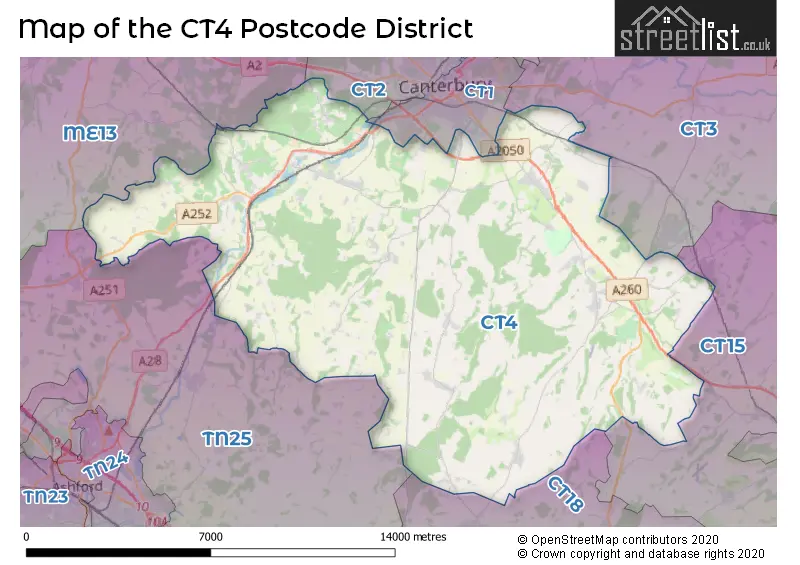
Map of the CT4 Postcode District
Explore the postcode district by using our interactive map.
Circles represent recorded crime; the larger the circle, the higher the crime rates.
Your support helps keep this site running!
If you enjoy using this website, consider buying me a coffee to help cover hosting costs.
Where is the CT4 District?
To give you an idea where the district is located we have created the following table showing nearby towns.
Nearest Towns to CT4
| Town | Distance (miles) | Direction |
|---|---|---|
| Canterbury | 4.60 | N |
| Fordwich | 6.17 | NNE |
| Ashford | 9.72 | WSW |
| Hythe | 9.83 | S |
| Whitstable | 10.21 | N |
| Folkestone | 10.30 | SSE |
| Faversham | 10.44 | NW |
| Herne Bay | 11.19 | NNE |
| Dover | 11.94 | ESE |
| Sandwich | 12.47 | ENE |
| Deal | 14.36 | E |
| New Romney | 16.71 | SSW |
| Sittingbourne | 16.91 | WNW |
| Ramsgate | 17.28 | ENE |
| Margate | 18.07 | NE |
| Minster | 18.24 | NW |
| Broadstairs | 18.88 | ENE |
| Lydd | 19.49 | SSW |
| Tenterden | 19.56 | WSW |
| Queenborough | 19.62 | NW |
The post town for this district is CANTERBURY.
Postcode Information for District CT4 (Total Geographical Postcodes: 891)
| Location | Post Town | Sector | Number of Postcodes |
|---|---|---|---|
| Chartham | CANTERBURY | CT4 7 | 198 |
| Barham | CANTERBURY | CT4 6 | 68 |
| Bridge | CANTERBURY | CT4 5 | 64 |
| Elham | CANTERBURY | CT4 6 | 53 |
| Stelling Minnis | CANTERBURY | CT4 6 | 53 |
| Chilham | CANTERBURY | CT4 8 | 46 |
| Petham | CANTERBURY | CT4 5 | 39 |
| Bekesbourne | CANTERBURY | CT4 5 | 37 |
| Kingston | CANTERBURY | CT4 6 | 26 |
| CANTERBURY | CANTERBURY | CT4 7 | 24 |
| Old Wives Lees | CANTERBURY | CT4 8 | 24 |
| Chartham Hatch | CANTERBURY | CT4 7 | 23 |
| Molash | CANTERBURY | CT4 8 | 21 |
| Waltham | CANTERBURY | CT4 5 | 20 |
| Shottenden | CANTERBURY | CT4 8 | 18 |
| Bishopsbourne | CANTERBURY | CT4 5 | 16 |
| Crundale | CANTERBURY | CT4 7 | 15 |
| Wootton | CANTERBURY | CT4 6 | 14 |
| Patrixbourne | CANTERBURY | CT4 5 | 13 |
| Godmersham | CANTERBURY | CT4 7 | 12 |
| Denton | CANTERBURY | CT4 6 | 11 |
| Rhodes Minnis | CANTERBURY | CT4 6 | 11 |
| Upper Hardres | CANTERBURY | CT4 6 | 9 |
| Lower Hardres | CANTERBURY | CT4 5 | 8 |
| Bossingham | CANTERBURY | CT4 6 | 8 |
| Mystole | CANTERBURY | CT4 7 | 7 |
| Bladbean | CANTERBURY | CT4 6 | 7 |
| Womenswold | CANTERBURY | CT4 6 | 6 |
| Woolage Village | CANTERBURY | CT4 6 | 6 |
| Woolage Green | CANTERBURY | CT4 6 | 4 |
| Garlinge Green | CANTERBURY | CT4 5 | 4 |
| Ottinge | CANTERBURY | CT4 6 | 4 |
| Pett Bottom | CANTERBURY | CT4 5 | 4 |
| Street End | CANTERBURY | CT4 7 | 4 |
| Street End | CANTERBURY | CT4 5 | 3 |
| Nackington | CANTERBURY | CT4 7 | 3 |
| Waltham | CANTERBURY | CT4 7 | 3 |
| Lower Hardres | CANTERBURY | CT4 7 | 2 |
| Anvil Green | CANTERBURY | CT4 7 | 1 |
| Pett Bottom | CANTERBURY | CT4 6 | 1 |
| Stelling Minnis | CANTERBURY | CT4 5 | 1 |
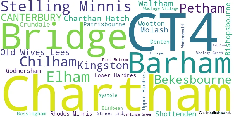
In the CT4 postcode district in Kent, the primary settlement is Bekesbourne, which has the highest count. Other significant settlements in the district include Bishopsbourne, Bridge, Garlinge Green, Lower Hardres, Patrixbourne, Petham, Pett Bottom, Stelling Minnis, Street End, Waltham, Barham, Bladbean, Bossingham, Denton, Elham, Kingston, Ottinge, Rhodes Minnis, Upper Hardres, Womenswold, Woolage Green, Woolage Village, Wootton, Canterbury, Anvil Green, Chartham, Chartham Hatch, Crundale, Godmersham, Mystole, Nackington, and Old Wives Lees. The most significant Postal Town in the district is Canterbury.
When it comes to local government, postal geography often disregards political borders. However, this district intersects the following councils: the district mostly encompasses the Canterbury District (B) (512 postal codes), followed by the Ashford District (B) area (137 postal codes), followed by the Folkestone and Hythe District area (135 postal codes), and finally, the Dover District area (24 postal codes).
The largest settlement in the CT4 postal code is Chartham followed by Bridge, and Barham.
The CT4 Postcode shares a border with CT1 (CANTERBURY), CT2 (CANTERBURY, Sturry, Blean), CT3 (Aylesham, Ash, Hersden), TN25 (Wye, Sellindge, ASHFORD), CT18 (Hawkinge, Capel-le-Ferne, Lyminge), CT15 (St. Margarets-At-Cliffe, Eythorne, Shepherdswell) and ME13 (FAVERSHAM, Boughton-under-Blean, Dunkirk).


Dentists in the CT4 District
No dentists found in this district.
Doctors in the CT4 District
| # | Name | Address | Type | Contact |
|---|---|---|---|---|
| 1 | Hawkinge And Elham | , OLD ROAD , ELHAM , CANTERBURY , KENT , CT4 6UH | GP PRACTICE | |
| 2 | Canterbury Medical Practice | , PATRIXBOURNE ROAD , BRIDGE , CANTERBURY , KENT , CT4 5BL | GP PRACTICE | |
| 3 | Old School Surgery | , CHARTHAM , CANTERBURY , KENT , CT4 7JY | GP PRACTICE | |
| 4 | Chartham Surgery | , CHARTHAM , CANTERBURY , KENT , CT4 7JU | BRANCH SURGERY |
Chemists in the CT4 District
| # | Name | Address | Type | Contact |
|---|---|---|---|---|
| 1 | Bridge Pharmacy | 16 HIGH STREET , BRIDGE , CANTERBURY , KENT , CT4 5JY | PHARMACY |
Opticians in the CT4 District
| # | Name | Address | Type | Contact |
|---|---|---|---|---|
| 1 | ELAINE EDWARDS HOME VISITING OPTOMETRIST | 2 HENBURY MANOR , HENBURY LANE , ELHAM , CANTERBURY , KENT , CT4 6NL | OPTICAL SITE |
Schools in the Sector
Bridge and Patrixbourne Church of England Primary School
Phase: Primary
Address: Conyngham Lane , Bridge , Canterbury
Postcode: CT4 5JX
Headteacher: Mr James Tibbles (Headteacher)
Ofsted Rating: Good
Petham Primary School
Phase: Primary
Address: Petham , Canterbury
Postcode: CT4 5RD
Headteacher: Mr Scott Guy ()
Ofsted Rating: Good
New School Canterbury
Phase: Not applicable
Address: New School Canterbury , Garlinge Green Road , Garlinge Green , Canterbury
Postcode: CT4 5RU
Headteacher: Mrs Beth Cuenco ()
Ofsted Rating: Inadequate
Stelling Minnis Church of England Primary School
Phase: Primary
Address: Bossingham Road , Stelling Minnis , Canterbury
Postcode: CT4 6DU
Headteacher: Mrs Julie Simmons (Headteacher)
Ofsted Rating: Good
Barham Church of England Primary School
Phase: Primary
Address: Valley Road , Barham , Barham C of E Primary School , CANTERBURY
Postcode: CT4 6NX
Headteacher: Mrs Alison Higgins Jo Duhig (Headteacher)
Ofsted Rating: Good
Elham Church of England Primary School
Phase: Primary
Address: Vicarage Lane , Elham , Canterbury
Postcode: CT4 6TT
Headteacher: Mr Dan File (Headteacher)
Ofsted Rating: Good
Simon Langton Grammar School for Boys
Phase: Secondary
Address: Langton Lane , Nackington Road , Canterbury
Postcode: CT4 7AS
Headteacher: Dr Ken Moffat (Headteacher)
Ofsted Rating: Outstanding
Chartham Primary School
Phase: Primary
Address: Shalmsford Street , Chartham , Canterbury
Postcode: CT4 7QN
Headteacher: Mr Dean Jones (Headteacher)
Ofsted Rating: Good
Chilham, St Mary's Church of England Primary School
Phase: Primary
Address: School Hill , Chilham , Canterbury
Postcode: CT4 8DE
Headteacher: Mrs Delia Cooper (Interim Executive Headteacher)
Ofsted Rating: Good
Hope View School
Phase: Not applicable
Address: Station Approach , Chilham , Canterbury
Postcode: CT4 8EG
Headteacher: Mr Paul Johnson (Headteacher)
Ofsted Rating: Good
Stations in the Sector
Bekesbourne
CRS Code: BKS
Operator: SE
Line: Chatham Main Line
Company: Southeastern
Chartham
CRS Code: CRT
Operator: SE
Line: Ashford to Ramsgate Line|Chatham Main Line
Company: Southeastern
Chilham
CRS Code: CIL
Operator: SE
Line: Ashford to Ramsgate Line
Company: Southeastern
Accessable Motorway Junctions
M2 J7
Average Driving Time from within the district: 9.02
Average Driving Distance: 7.97
Number of Postcodes that can access the Motorway Junction: 538
M2 J6
Average Driving Time from within the district: 9.84
Average Driving Distance: 8.68
Number of Postcodes that can access the Motorway Junction: 433
M20 J11
Average Driving Time from within the district: 11.82
Average Driving Distance: 9.64
Number of Postcodes that can access the Motorway Junction: 417
M20 J11A
Average Driving Time from within the district: 12.55
Average Driving Distance: 10.22
Number of Postcodes that can access the Motorway Junction: 439
M20 J13
Average Driving Time from within the district: 13.08
Average Driving Distance: 10.41
Number of Postcodes that can access the Motorway Junction: 386
M20 J12
Average Driving Time from within the district: 13.54
Average Driving Distance: 10.86
Number of Postcodes that can access the Motorway Junction: 404
M20 J10A
Average Driving Time from within the district: 13.69
Average Driving Distance: 11.38
Number of Postcodes that can access the Motorway Junction: 658
M20 J9
Average Driving Time from within the district: 13.75
Average Driving Distance: 10.06
Number of Postcodes that can access the Motorway Junction: 357
M20 J10
Average Driving Time from within the district: 14.05
Average Driving Distance: 10.99
Number of Postcodes that can access the Motorway Junction: 413
Weather Forecast for Kent C.C.C.
| Time Period | Icon | Description | Temperature | Rain Probability | Wind |
|---|---|---|---|---|---|
| 15:00 to 18:00 | Cloudy | 5.0°C (feels like 3.0°C) | 5.00% | SE 4 mph | |
| 18:00 to 21:00 | Cloudy | 2.0°C (feels like -1.0°C) | 5.00% | ESE 7 mph | |
| 21:00 to 00:00 | Cloudy | 2.0°C (feels like -1.0°C) | 5.00% | SE 7 mph |
| Time Period | Icon | Description | Temperature | Rain Probability | Wind |
|---|---|---|---|---|---|
| 00:00 to 03:00 | Cloudy | 2.0°C (feels like -1.0°C) | 5.00% | SE 7 mph | |
| 03:00 to 06:00 | Cloudy | 2.0°C (feels like -1.0°C) | 7.00% | ESE 7 mph | |
| 06:00 to 09:00 | Cloudy | 2.0°C (feels like -1.0°C) | 8.00% | ESE 7 mph | |
| 09:00 to 12:00 | Cloudy | 3.0°C (feels like 0.0°C) | 9.00% | ESE 7 mph | |
| 12:00 to 15:00 | Cloudy | 5.0°C (feels like 3.0°C) | 11.00% | SE 7 mph | |
| 15:00 to 18:00 | Cloudy | 5.0°C (feels like 4.0°C) | 12.00% | SSE 4 mph | |
| 18:00 to 21:00 | Cloudy | 4.0°C (feels like 2.0°C) | 15.00% | NNE 7 mph | |
| 21:00 to 00:00 | Light rain | 5.0°C (feels like 2.0°C) | 44.00% | SW 7 mph |
| Time Period | Icon | Description | Temperature | Rain Probability | Wind |
|---|---|---|---|---|---|
| 00:00 to 03:00 | Light rain | 5.0°C (feels like 2.0°C) | 46.00% | N 7 mph | |
| 03:00 to 06:00 | Light rain | 4.0°C (feels like 2.0°C) | 46.00% | NNW 7 mph | |
| 06:00 to 09:00 | Overcast | 4.0°C (feels like 1.0°C) | 21.00% | W 9 mph | |
| 09:00 to 12:00 | Overcast | 4.0°C (feels like 1.0°C) | 18.00% | WSW 9 mph | |
| 12:00 to 15:00 | Overcast | 6.0°C (feels like 2.0°C) | 13.00% | W 11 mph | |
| 15:00 to 18:00 | Overcast | 6.0°C (feels like 3.0°C) | 14.00% | WSW 11 mph | |
| 18:00 to 21:00 | Cloudy | 5.0°C (feels like 2.0°C) | 13.00% | WSW 9 mph | |
| 21:00 to 00:00 | Cloudy | 5.0°C (feels like 2.0°C) | 13.00% | WSW 9 mph |
| Postal Sector | Delivery Office |
|---|---|
| CT4 5 | Canterbury Delivery Office |
| CT4 6 | Canterbury Delivery Office |
| CT4 7 | Canterbury Delivery Office |
| CT4 8 | Canterbury Delivery Office |
| CT4 6 | Barham Scale Payment Delivery Office |
| C | T | 4 | - | X | X | X |
| C | T | 4 | Space | Numeric | Letter | Letter |
Street List for the CT4 District
Current Monthly Rental Prices
| # Bedrooms | Min Price | Max Price | Avg Price |
|---|---|---|---|
| 1 | £900 | £900 | £900 |
| 2 | £975 | £1,100 | £1,038 |
| 3 | £1,400 | £2,200 | £1,825 |
| 4 | £1,800 | £2,200 | £2,000 |
Current House Prices
| # Bedrooms | Min Price | Max Price | Avg Price |
|---|---|---|---|
| £98,400 | £1,500,000 | £710,850 | |
| 1 | £145,000 | £200,000 | £172,500 |
| 2 | £171,500 | £685,000 | £334,307 |
| 3 | £225,000 | £895,000 | £511,827 |
| 4 | £350,000 | £3,500,000 | £918,678 |
| 5 | £500,000 | £6,999,950 | £1,477,095 |
| 6 | £995,000 | £2,750,000 | £1,676,667 |
| 7 | £2,000,000 | £2,750,000 | £2,416,667 |
| 8 | £4,850,000 | £4,850,000 | £4,850,000 |
| 15 | £2,750,000 | £2,750,000 | £2,750,000 |
Estate Agents
| Logo | Name | Brand Name | Address | Contact Number |
|---|---|---|---|---|
 | Lyminge, Folkestone | Laing Bennett Estate & Letting Agents | The Estate Office, 8 Station Road, Lyminge, CT18 8HP | 01303 761733 |
 | Canterbury | Miles & Barr | 14 Lower Chantry Lane Canterbury CT1 1UF | 01227 532461 |
 | Canterbury | Colebrook Sturrock | Bank Buildings, Elham, Canterbury, CT4 6TD | 01303 761690 |
 | Canterbury | Strutt & Parker | 2 St. Margarets Street, Canterbury, CT1 2SL | 01227 532506 |
 | Ashford | Hobbs Parker Estate Agents | Romney House Monument Way, Orbital Park, Ashford, TN24 0HB | 01233 542521 |
Yearly House Price Averages for the District
| Type of Property | 2018 Average | 2018 Sales | 2017 Average | 2017 Sales | 2016 Average | 2016 Sales | 2015 Average | 2015 Sales |
|---|---|---|---|---|---|---|---|---|
| Detached | £542,248 | 109 | £505,097 | 113 | £500,070 | 95 | £468,834 | 115 |
| Semi-Detached | £340,807 | 61 | £341,856 | 65 | £297,886 | 69 | £299,084 | 58 |
| Terraced | £304,075 | 59 | £279,607 | 56 | £273,791 | 61 | £243,759 | 69 |
| Flats | £176,905 | 11 | £175,156 | 16 | £160,625 | 24 | £163,745 | 30 |