
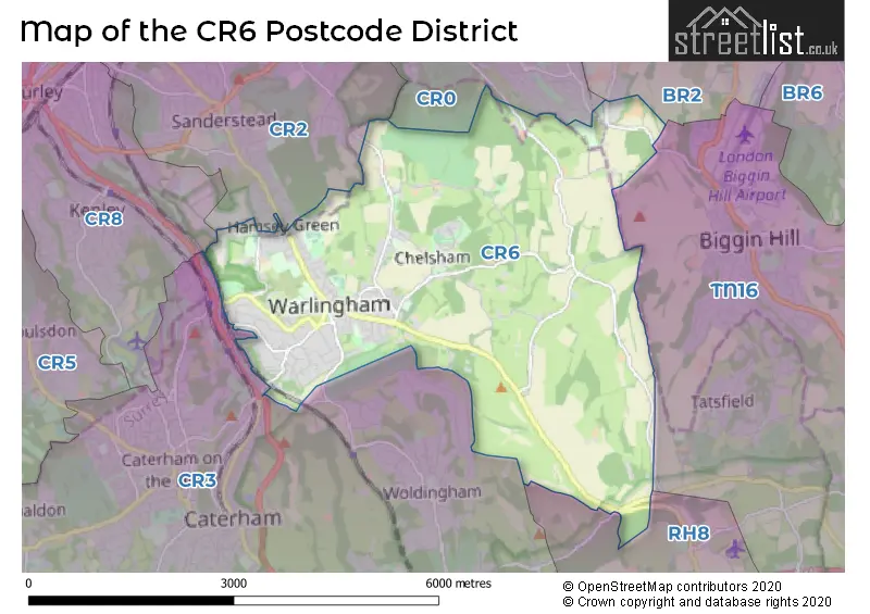
Map of the CR6 Postcode District
Explore the postcode district by using our interactive map.
Circles represent recorded crime; the larger the circle, the higher the crime rates.
Your support helps keep this site running!
If you enjoy using this website, consider buying me a coffee to help cover hosting costs.
Where is the CR6 District?
To give you an idea where the district is located we have created the following table showing nearby towns.
Nearest Towns to CR6
| Town | Distance (miles) | Direction |
|---|---|---|
| Caterham | 3.08 | SW |
| Oxted | 3.77 | SSE |
| Westerham | 5.18 | SE |
| Banstead | 7.82 | W |
| Redhill | 8.00 | SW |
| Edenbridge | 8.82 | SSE |
| Reigate | 9.34 | WSW |
| Sevenoaks | 9.81 | ESE |
| Ewell | 10.08 | WNW |
| Swanley | 10.44 | NE |
| Epsom | 10.60 | W |
| Horley | 11.35 | SSW |
| East Grinstead | 12.94 | S |
| Leatherhead | 13.31 | W |
| City of Westminster | 13.85 | NNW |
| Dorking | 14.29 | WSW |
| City of London | 14.36 | NNW |
| Tonbridge | 15.27 | ESE |
| Esher | 15.30 | WNW |
The post town for this district is WARLINGHAM.
Postcode Information for District CR6 (Total Geographical Postcodes: 258)
| Location | Post Town | Sector | Number of Postcodes |
|---|---|---|---|
| WARLINGHAM | WARLINGHAM | CR6 9 | 255 |
| Chelsham | WARLINGHAM | CR6 9 | 3 |
Retail and Shopping in CR6
Street
Town
Locality
Number of Shops
Central Postcode
View on Google Maps
LIMPSFIELD ROAD
WARLINGHAM
31
CR6 9HA
View on Google Maps
THE GREEN
WARLINGHAM
14
CR6 9NA
View on Google Maps
| Street | Town | Locality | Number of Shops | Central Postcode | View on Google Maps |
|---|---|---|---|---|---|
| LIMPSFIELD ROAD | WARLINGHAM | 31 | CR6 9HA | View on Google Maps | |
| THE GREEN | WARLINGHAM | 14 | CR6 9NA | View on Google Maps |
The primary settlement in the CR6 postcode district is Warlingham, located in Greater London. Other significant settlements in the area include Chelsham. The county associated with the CR6 postcode district is Surrey. The most significant post town in this district is also Warlingham.
When it comes to local government, postal geography often disregards political borders. However, this district intersects the following councils: the district mostly encompasses the Tandridge District (244 postal codes), and finally, the Croydon London Boro area (7 postal codes).
The CR6 postal code covers the settlement of WARLINGHAM.
The CR6 Postcode shares a border with CR0 (CROYDON), CR2 (SOUTH CROYDON), BR2 (BROMLEY, HAYES, SHORTLANDS), TN16 (BIGGIN HILL, WESTERHAM), CR3 (CATERHAM, WHYTELEAFE), CR8 (PURLEY, KENLEY) and RH8 (OXTED, HURST GREEN, LIMPSFIELD).
Postcode Sectors


Dentists in the CR6 District
| # | Name | Address | Type | Contact |
|---|---|---|---|---|
| 1 | Hamsey Green Dental Surgery | 85A LIMPSFIELD ROAD , WARLINGHAM , SURREY , CR6 9RH | GENERAL DENTAL PRACTICE | |
| 2 | Complete Dentistry Surrey | 1 CHURCH ROAD , WARLINGHAM , CR6 9NW | GENERAL DENTAL PRACTICE |
Doctors in the CR6 District
| # | Name | Address | Type | Contact |
|---|---|---|---|---|
| 1 | Elizabeth House Medical Practice | , WARLINGHAM , SURREY , CR6 9LF | GP PRACTICE | |
| 2 | Warlingham Green Med Prac | , WARLINGHAM , SURREY , CR6 9NW | GP PRACTICE | |
| 3 | Chaldon Road Surgery | , WARLINGHAM , SURREY , CR6 9NW | BRANCH SURGERY | |
| 4 | Waringham Green Medical Practice - Covid Local Vaccination Service | , WARLINGHAM , CR6 9NW | BRANCH SURGERY |
Chemists in the CR6 District
| # | Name | Address | Type | Contact |
|---|---|---|---|---|
| 1 | Kamsons Pharmacy | 46-48 THE GREEN , WARLINGHAM , SURREY , CR6 9NA | PHARMACY |
Opticians in the CR6 District
No Opticians found in this district.
Schools in the Sector
Hamsey Green Primary
Phase: Primary
Address: Tithepit Shaw Lane , Warlingham
Postcode: CR6 9AN
Headteacher: Mrs Helen Smith (Acting Headteacher)
Ofsted Rating: Requires improvement
Hamsey Green Primary
Phase: Primary
Address: Tithepit Shaw Lane , Warlingham
Postcode: CR6 9AN
Headteacher: Mrs Nicola Mace (Headteacher)
Ofsted Rating: Good
Warlingham Village Primary School
Phase: Primary
Address: 85 Farleigh Road , Warlingham Village School , Warlingham
Postcode: CR6 9EJ
Headteacher: Mrs Anna Hallett (Headteacher)
Ofsted Rating: Outstanding
Warlingham School
Phase: Secondary
Address: Tithepit Shaw Lane , Warlingham
Postcode: CR6 9YB
Headteacher: Mr Paul Foster (Headteacher)
Ofsted Rating: Good
Stations in the Sector
No stations found in this postcode district.
Accessable Motorway Junctions
M25 J6
Average Driving Time from within the district: 6.74
Average Driving Distance: 4.43
Number of Postcodes that can access the Motorway Junction: 250
M23 J8
Average Driving Time from within the district: 9.62
Average Driving Distance: 7.40
Number of Postcodes that can access the Motorway Junction: 250
M25 J7
Average Driving Time from within the district: 9.66
Average Driving Distance: 7.45
Number of Postcodes that can access the Motorway Junction: 250
M25 J8
Average Driving Time from within the district: 12.23
Average Driving Distance: 10.42
Number of Postcodes that can access the Motorway Junction: 215
M25 J5
Average Driving Time from within the district: 17.44
Average Driving Distance: 10.31
Number of Postcodes that can access the Motorway Junction: 34
Weather Forecast for Warlingham
| Time Period | Icon | Description | Temperature | Rain Probability | Wind |
|---|---|---|---|---|---|
| 21:00 to 00:00 | Partly cloudy (night) | 2.0°C (feels like -1.0°C) | 0.00% | S 4 mph |
| Time Period | Icon | Description | Temperature | Rain Probability | Wind |
|---|---|---|---|---|---|
| 00:00 to 03:00 | Clear night | 1.0°C (feels like -2.0°C) | 0.00% | S 7 mph | |
| 03:00 to 06:00 | Partly cloudy (night) | 1.0°C (feels like -2.0°C) | 1.00% | SSW 7 mph | |
| 06:00 to 09:00 | Cloudy | 2.0°C (feels like -1.0°C) | 4.00% | S 7 mph | |
| 09:00 to 12:00 | Overcast | 3.0°C (feels like 0.0°C) | 10.00% | S 9 mph | |
| 12:00 to 15:00 | Cloudy | 6.0°C (feels like 3.0°C) | 8.00% | SSW 11 mph | |
| 15:00 to 18:00 | Overcast | 7.0°C (feels like 4.0°C) | 8.00% | SSW 9 mph | |
| 18:00 to 21:00 | Cloudy | 5.0°C (feels like 2.0°C) | 15.00% | S 9 mph | |
| 21:00 to 00:00 | Cloudy | 5.0°C (feels like 1.0°C) | 8.00% | SSW 11 mph |
| Time Period | Icon | Description | Temperature | Rain Probability | Wind |
|---|---|---|---|---|---|
| 00:00 to 03:00 | Cloudy | 5.0°C (feels like 1.0°C) | 6.00% | SSW 11 mph | |
| 03:00 to 06:00 | Cloudy | 5.0°C (feels like 1.0°C) | 6.00% | SSW 13 mph | |
| 06:00 to 09:00 | Cloudy | 5.0°C (feels like 1.0°C) | 5.00% | SSW 13 mph | |
| 09:00 to 12:00 | Cloudy | 6.0°C (feels like 1.0°C) | 5.00% | SSW 16 mph | |
| 12:00 to 15:00 | Cloudy | 8.0°C (feels like 4.0°C) | 4.00% | SSW 18 mph | |
| 15:00 to 18:00 | Overcast | 8.0°C (feels like 4.0°C) | 11.00% | SSW 16 mph | |
| 18:00 to 21:00 | Light rain | 8.0°C (feels like 4.0°C) | 54.00% | SSW 16 mph | |
| 21:00 to 00:00 | Light rain shower (night) | 7.0°C (feels like 4.0°C) | 43.00% | WSW 13 mph |
| Time Period | Icon | Description | Temperature | Rain Probability | Wind |
|---|---|---|---|---|---|
| 00:00 to 03:00 | Clear night | 6.0°C (feels like 2.0°C) | 5.00% | WSW 11 mph | |
| 03:00 to 06:00 | Clear night | 4.0°C (feels like 0.0°C) | 0.00% | W 11 mph | |
| 06:00 to 09:00 | Clear night | 3.0°C (feels like -1.0°C) | 0.00% | W 9 mph | |
| 09:00 to 12:00 | Partly cloudy (day) | 3.0°C (feels like 0.0°C) | 1.00% | W 9 mph | |
| 12:00 to 15:00 | Cloudy | 6.0°C (feels like 4.0°C) | 4.00% | WNW 7 mph | |
| 15:00 to 18:00 | Cloudy | 7.0°C (feels like 5.0°C) | 5.00% | NW 7 mph | |
| 18:00 to 21:00 | Cloudy | 4.0°C (feels like 2.0°C) | 4.00% | NNW 4 mph | |
| 21:00 to 00:00 | Partly cloudy (night) | 3.0°C (feels like 0.0°C) | 1.00% | N 7 mph |
| Time Period | Icon | Description | Temperature | Rain Probability | Wind |
|---|---|---|---|---|---|
| 00:00 to 03:00 | Clear night | 2.0°C (feels like -1.0°C) | 1.00% | NNE 7 mph | |
| 03:00 to 06:00 | Clear night | 1.0°C (feels like -3.0°C) | 1.00% | NNE 7 mph | |
| 06:00 to 09:00 | Clear night | 0.0°C (feels like -4.0°C) | 1.00% | NNE 9 mph | |
| 09:00 to 12:00 | Sunny day | 2.0°C (feels like -2.0°C) | 2.00% | NE 9 mph | |
| 12:00 to 15:00 | Sunny day | 5.0°C (feels like 2.0°C) | 1.00% | ENE 11 mph | |
| 15:00 to 18:00 | Sunny day | 6.0°C (feels like 3.0°C) | 1.00% | NE 11 mph | |
| 18:00 to 21:00 | Clear night | 4.0°C (feels like 0.0°C) | 1.00% | NE 11 mph | |
| 21:00 to 00:00 | Clear night | 3.0°C (feels like -2.0°C) | 1.00% | NE 11 mph |
| Postal Sector | Delivery Office |
|---|---|
| CR6 9 | Caterham Delivery Office |
| C | R | 6 | - | X | X | X |
| C | R | 6 | Space | Numeric | Letter | Letter |
Street List for the CR6 District
Current Monthly Rental Prices
| # Bedrooms | Min Price | Max Price | Avg Price |
|---|---|---|---|
| 2 | £1,350 | £2,995 | £2,184 |
| 5 | £4,500 | £4,500 | £4,500 |
Current House Prices
| # Bedrooms | Min Price | Max Price | Avg Price |
|---|---|---|---|
| 1 | £174,950 | £375,000 | £250,216 |
| 2 | £189,950 | £895,000 | £441,749 |
| 3 | £350,000 | £750,000 | £565,452 |
| 4 | £525,000 | £1,400,000 | £815,000 |
| 5 | £600,000 | £2,350,000 | £1,292,500 |
| 6 | £2,000,000 | £2,500,000 | £2,250,000 |
| 8 | £1,850,000 | £1,850,000 | £1,850,000 |
Estate Agents
| Logo | Name | Brand Name | Address | Contact Number |
|---|---|---|---|---|
 | Sanderstead | Hubbard Torlot | 335 Limpsfield Road Sanderstead Surrey CR2 9BY | 020 3907 7779 |
 | Warlingham | Park & Bailey | 426 Limpsfield Road, Warlingham, CR6 9LA | 01883 770543 |
 | Warlingham | Rayners Town & Country | 2 Glebe Road, Warlingham, CR6 9NJ | 01883 771152 |
 | Sanderstead | Pollard Machin | 45 Limpsfield Road, South Croydon, CR2 9LA | 020 3872 5487 |
 | Oxted | Robert Leech Estate Agents | 72 Station Road East, Oxted, RH8 0PG | 01883 779596 |
Yearly House Price Averages for the District
| Type of Property | 2018 Average | 2018 Sales | 2017 Average | 2017 Sales | 2016 Average | 2016 Sales | 2015 Average | 2015 Sales |
|---|---|---|---|---|---|---|---|---|
| Detached | £788,891 | 44 | £901,120 | 54 | £774,566 | 53 | £797,068 | 71 |
| Semi-Detached | £426,886 | 42 | £456,913 | 59 | £461,518 | 52 | £414,763 | 50 |
| Terraced | £441,489 | 19 | £468,746 | 12 | £416,542 | 24 | £349,180 | 25 |
| Flats | £350,442 | 79 | £318,080 | 62 | £337,545 | 72 | £273,931 | 77 |