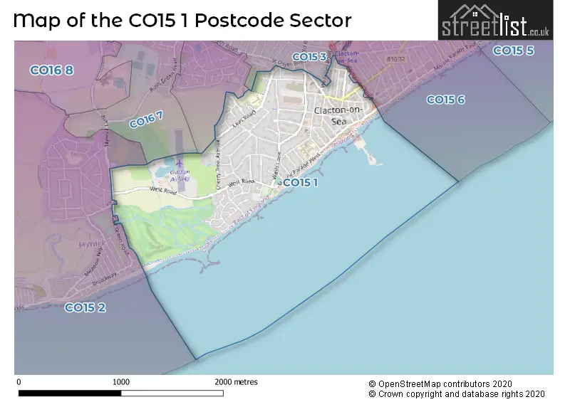
A wide range of spatial data has been analysed to present this overview of the CO15 1 Postcode sector. If you would like anything added, please contact us.
The CO15 1 postcode sector is within the county of Essex.
Did you know? According to the 2021 Census, the CO15 1 postcode sector is home to a bustling 7,204 residents!
Given that each sector allows for 400 unique postcode combinations. Letters C, I, K, M, O and V are not allowed in the last two letters of a postcode. With 235 postcodes already in use, this leaves 165 units available.
The CO15 1 postal code covers the settlement of CLACTON-ON-SEA.
The CO15 1 Postcode shares a border with CO15 2 (Jaywick, CLACTON-ON-SEA), CO15 3 (CLACTON-ON-SEA), CO16 7 (CLACTON-ON-SEA) and CO15 6 (CLACTON-ON-SEA).
Map of the CO15 1 Postcode Sector
Explore the CO15 1 postcode sector by using our interactive map.
The sector is within the post town of CLACTON-ON-SEA.
CO15 1 is a postcode sector within the CO15 postcode district which is within the CO Colchester postcode area.
The Royal Mail delivery office for the CO15 1 postal sector is the Clacton-on-sea Delivery Office.
The area of the CO15 1 postcode sector is 0.95 square miles which is 2.47 square kilometres or 610.12 square acres.
Your support helps keep this site running!
If you enjoy using this website, consider buying me a coffee to help cover hosting costs.


| C | O | 1 | 5 | - | 1 | X | X |
| C | O | 1 | 5 | Space | 1 | Letter | Letter |
Official List of Streets
CLACTON-ON-SEA (88 Streets)
Unofficial Streets or Alternative Spellings
Weather Forecast for CO15 1
Weather Forecast for Clacton - Martello Tower (Beach)

House Prices in the CO15 1 Postcode Sector
| Type of Property | 2018 Average | 2018 Sales | 2017 Average | 2017 Sales | 2016 Average | 2016 Sales | 2015 Average | 2015 Sales |
|---|---|---|---|---|---|---|---|---|
| Detached | £305,096 | 31 | £285,000 | 33 | £274,256 | 40 | £235,453 | 48 |
| Semi-Detached | £221,327 | 29 | £217,215 | 22 | £178,958 | 24 | £161,059 | 26 |
| Terraced | £157,583 | 12 | £186,260 | 25 | £155,328 | 18 | £162,367 | 15 |
| Flats | £120,246 | 63 | £115,453 | 70 | £102,274 | 90 | £88,566 | 64 |
Important Postcodes CO15 1 in the Postcode Sector
CO15 1DA is the postcode for St. James Surgery, 89 Wash Lane
CO15 1DL is the postcode for Alton Park Junior School, Leas Road, and MAIN BUILDING, Alton Park Junior School, Leas Road
CO15 1ET is the postcode for Essex Police, Clacton Police Station, 8 Beatrice Road
CO15 1JA is the postcode for Reunion House, 35 Jackson Road
CO15 1JD is the postcode for Magnet House, Jackson Road, and Essex County Council, Magnet House, Jackson Road
CO15 1LH is the postcode for MAIN BUILDING, Clacton & District Hospital, Tower Road, BUILDING 12 PHYSIO, Clacton & District Hospital, Tower Road, Peter Bruff, Clacton Hospital, Tower Road, B03 - MIU, Clacton & District Hospital, Tower Road, North Essex Partnership NHS Foundation Trust, Clacton & District Hospital, BUILDING 10 & 11, Clacton & District Hospital, Tower Road, Ivy Benson, Clacton Hospital, Tower Road, Martello, Clacton Hospital, Tower Road, North East Essex PCT, Clacton Hospital, PETER BRUFF AND MARTELLO WARDS, Clacton & District Hospital, Tower Road, BUILDING 10, Clacton & District Hospital, Tower Road, B01 - MATERNITY/KATE GRANT/JUBLIE, Clacton & District Hospital, Tower Road, North Essex Partnership NHS Foundation Trust, Landermere Centre, Landermere Centre, Freeland Road, Seaview, Clacton Hospital, Tower Road, B05 RECKITT LODGE, Clacton & District Hospital, Tower Road, and B02-XRAY-PHLEBOMY, Clacton & District Hospital, Tower Road
CO15 1NJ is the postcode for Barnes House, 92 Pier Avenue, and Ranworth Surgery, 103 Pier Avenue
CO15 1NP is the postcode for Post Office, High Street
CO15 1RS is the postcode for Benefits Agency, 55 Station Road, and 55 Station Road
CO15 1SE is the postcode for Town Hall, Station Road
CO15 1SF is the postcode for Clacton Central Library, 96 Station Road
CO15 1TN is the postcode for Council Tax Offices, 88-90 Pier Avenue
| The CO15 1 Sector is within these Local Authorities |
|
|---|---|
| The CO15 1 Sector is within these Counties |
|
| The CO15 1 Sector is within these Water Company Areas |
|