
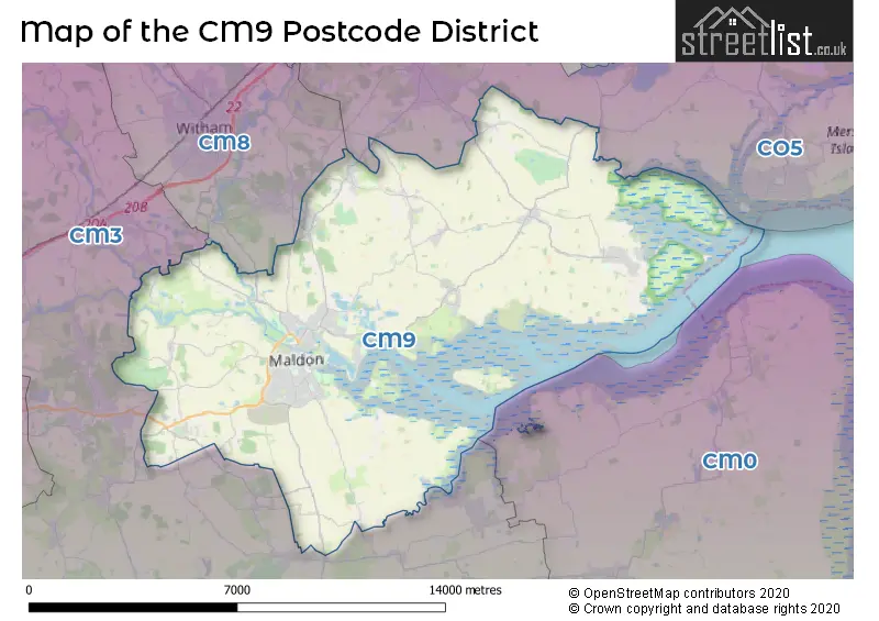
Map of the CM9 Postcode District
Explore the postcode district by using our interactive map.
Circles represent recorded crime; the larger the circle, the higher the crime rates.
Your support helps keep this site running!
If you enjoy using this website, consider buying me a coffee to help cover hosting costs.
Where is the CM9 District?
To give you an idea where the district is located we have created the following table showing nearby towns.
Nearest Towns to CM9
| Town | Distance (miles) | Direction |
|---|---|---|
| Witham | 5.29 | NW |
| Southminster | 7.26 | SE |
| West Mersea | 8.16 | ENE |
| South Woodham Ferrers | 8.31 | SSW |
| Coggeshall | 8.87 | NNW |
| Burnham-on-Crouch | 9.18 | SSE |
| Chelmsford | 10.91 | W |
| Rochford | 11.33 | S |
| Braintree | 11.82 | NW |
| Rayleigh | 12.16 | SSW |
| Colchester | 12.39 | NE |
| Wivenhoe | 12.56 | NE |
| Wickford | 12.76 | SW |
| Brightlingsea | 13.52 | ENE |
| Southend-on-Sea | 14.23 | S |
| Halstead | 14.28 | NNW |
| Billericay | 15.76 | WSW |
| Canvey Island | 16.46 | SSW |
| Basildon | 16.92 | SW |
The post town for this district is MALDON.
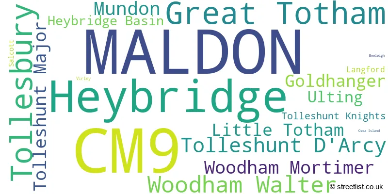
Postcode Information for District CM9 (Total Geographical Postcodes: 983)
| Location | Post Town | Sector | Number of Postcodes |
|---|---|---|---|
| MALDON | MALDON | CM9 6 | 211 |
| Heybridge | MALDON | CM9 4 | 183 |
| MALDON | MALDON | CM9 5 | 128 |
| Great Totham | MALDON | CM9 8 | 70 |
| Tollesbury | MALDON | CM9 8 | 67 |
| Woodham Walter | MALDON | CM9 6 | 37 |
| Tolleshunt D'Arcy | MALDON | CM9 8 | 35 |
| MALDON | MALDON | CM9 4 | 33 |
| Tolleshunt Major | MALDON | CM9 8 | 28 |
| Mundon | MALDON | CM9 6 | 27 |
| Little Totham | MALDON | CM9 8 | 27 |
| Woodham Mortimer | MALDON | CM9 6 | 26 |
| Goldhanger | MALDON | CM9 8 | 23 |
| Ulting | MALDON | CM9 6 | 21 |
| Heybridge Basin | MALDON | CM9 4 | 19 |
| Tolleshunt Knights | MALDON | CM9 8 | 18 |
| Salcott | MALDON | CM9 8 | 13 |
| Langford | MALDON | CM9 6 | 5 |
| Langford | MALDON | CM9 4 | 4 |
| Heybridge | MALDON | CM9 8 | 3 |
| Virley | MALDON | CM9 8 | 2 |
| Beeleigh | MALDON | CM9 6 | 1 |
| MALDON | MALDON | CM9 8 | 1 |
| Osea Island | MALDON | CM9 8 | 1 |
Retail and Shopping in CM9
Street
Town
Locality
Number of Shops
Central Postcode
View on Google Maps
HIGH STREET
MALDON
173
CM9 5PN
View on Google Maps
COLCHESTER ROAD
MALDON
15
CM9 4GD
View on Google Maps
FULLBRIDGE
MALDON
13
CM9 4LE
View on Google Maps
EDWARDS WALK
MALDON
12
CM9 5PS
View on Google Maps
MILL ROAD
MALDON
10
CM9 5HZ
View on Google Maps
THE CAUSEWAY
MALDON
10
CM9 4DY
View on Google Maps
WASHINGTON ROAD
MALDON
6
CM9 6JE
View on Google Maps
WENLOCK WAY
MALDON
6
CM9 5AD
View on Google Maps
WYCKE HILL
MALDON
6
CM9 6SH
View on Google Maps
| Street | Town | Locality | Number of Shops | Central Postcode | View on Google Maps |
|---|---|---|---|---|---|
| HIGH STREET | MALDON | 173 | CM9 5PN | View on Google Maps | |
| COLCHESTER ROAD | MALDON | 15 | CM9 4GD | View on Google Maps | |
| FULLBRIDGE | MALDON | 13 | CM9 4LE | View on Google Maps | |
| EDWARDS WALK | MALDON | 12 | CM9 5PS | View on Google Maps | |
| MILL ROAD | MALDON | 10 | CM9 5HZ | View on Google Maps | |
| THE CAUSEWAY | MALDON | 10 | CM9 4DY | View on Google Maps | |
| WASHINGTON ROAD | MALDON | 6 | CM9 6JE | View on Google Maps | |
| WENLOCK WAY | MALDON | 6 | CM9 5AD | View on Google Maps | |
| WYCKE HILL | MALDON | 6 | CM9 6SH | View on Google Maps |
The primary settlement in the CM9 postcode district is Maldon, located in the county of Essex, England. Other significant settlements in this postcode district include Heybridge, Heybridge Basin, Langford, Beeleigh, Mundon, Ulting, Woodham Mortimer, Woodham Walter, Goldhanger, Great Totham, Little Totham, Osea Island, Salcott, Tollesbury, Tolleshunt D'Arcy, Tolleshunt Knights, Tolleshunt Major, and Virley. The most significant post town in this postcode district is Maldon.
When it comes to local government, postal geography often disregards political borders. However, this district intersects the following councils: the district mostly encompasses the Maldon District (B) (999 postal codes), followed by the Colchester District (B) area (9 postal codes), and finally, the Braintree District area (3 postal codes).
The largest settlement in the CM9 postal code is MALDON followed by Heybridge, and Tollesbury.
The postcode area has a boundary with Blackwater and Thames Estuary.
The CM9 Postcode shares a border with CM8 (WITHAM, Silver End, Wickham Bishops), CO5 (Tiptree, West Mersea, Kelvedon), CM0 (BURNHAM-ON-CROUCH, SOUTHMINSTER, St. Lawrence) and CM3 (South Woodham Ferrers, Danbury, Hatfield Peverel).


Dentists in the CM9 District
| # | Name | Address | Type | Contact |
|---|---|---|---|---|
| 1 | West Square Dental Care | 2 WEST SQUARE , MALDON , ESSEX , CM9 5QX | GENERAL DENTAL PRACTICE | |
| 2 | Dental Surgery | UNIT 25-26 , BENTALLS SHOPPING CENTRE , HEYBRIDGE , MALDON , ESSEX , CM9 4GD | GENERAL DENTAL PRACTICE | |
| 3 | Carmelite Dental Practice | 40 WHITE HORSE LANE , MALDON , ESSEX , CM9 5QP | GENERAL DENTAL PRACTICE | |
| 4 | Quest Dental Care | 129 HIGH STREET , MALDON , ESSEX , CM9 5BS | GENERAL DENTAL PRACTICE |
Doctors in the CM9 District
| # | Name | Address | Type | Contact |
|---|---|---|---|---|
| 1 | Bentalls Complex Surgery | , HEYBRIDGE , MALDON , ESSEX , CM9 5DF | BRANCH SURGERY | |
| 2 | Church Street Surgery | , TOLLESHUNT D'ARCY , MALDON , ESSEX , CM9 8TS | BRANCH SURGERY | |
| 3 | Goldring House Surgery | , HAYBRIDGE , ESSEX , CM9 4BW | BRANCH SURGERY | |
| 4 | Longfield Medical Centre | , MALDON , ESSEX , CM9 5DF | GP PRACTICE | |
| 5 | The Tollesbury Practice | , 25 HIGH STREET , TOLLESBURY , MALDON , ESSEX , CM9 8RG | GP PRACTICE | |
| 6 | Blackwater Medical Centre | , MALDON , ESSEX , CM9 5GP | GP PRACTICE | |
| 7 | Goldhanger Branch Surgery | , HEAD STREET , GOLDHANGER , MALDON , ESSEX , CM9 8AY | BRANCH SURGERY | |
| 8 | Longfield Medical Centre - Heybridge Bentalls Complex - Covid Local Vaccination Service 2 | , COLCHESTER ROAD , HEYBRIDGE , MALDON , CM9 4GD | BRANCH SURGERY |
Chemists in the CM9 District
| # | Name | Address | Type | Contact |
|---|---|---|---|---|
| 1 | Tollesbury Pharmacy | 12A EAST STREET , TOLLESBURY , MALDON , ESSEX , CM9 8QD | PHARMACY | |
| 2 | Longfield Pharmacy | LONGFIELD MEDICAL CENTRE , PRINCES ROAD , MALDON , ESSEX , CM9 5DF | PHARMACY | |
| 3 | Tesco In-store Pharmacy | TESCO STORE , INSTORE PHARMACY , FULLBRIDGE , MALDON , ESSEX , CM9 4LE | PHARMACY | |
| 4 | Boots | 54 HIGH STREET , MALDON , ESSEX , CM9 5PN | PHARMACY | |
| 5 | Blackwater Pharma | BLACKWATER MEDICAL CENTRE , PRINCES ROAD , MALDON , ESSEX , CM9 5GP | PHARMACY | |
| 6 | Simplymeds Online | UNIT K2 BECKINGHAM BUSINESS PARK , TOLLESHUNT MAJOR , MALDON , ESSEX , CM9 8LZ | PHARMACY | |
| 7 | Heybridge Pharmacy | UNIT 10A-10B , BENTALLS SHOPPING CENTRE , COLCHESTER ROAD, HEYBRIDGE , MALDON , ESSEX , CM9 4GD | PHARMACY | |
| 8 | Allied Pharmacy Bentalls Centre | UNIT 10A-10B , BENTALLS SHOPPING CENTRE , COLCHESTER ROAD, HEYBRIDGE , MALDON , ESSEX , CM9 4GD | PHARMACY |
Opticians in the CM9 District
| # | Name | Address | Type | Contact |
|---|---|---|---|---|
| 1 | MARTIN JAMES LTD | 1 MARKET HILL , MALDON , ESSEX , CM9 4PZ | OPTICAL SITE | |
| 2 | BOOTS OPTICIANS (MALDON) | 75 HIGH STREET , MALDON , ESSEX , CM9 5EP | OPTICAL SITE | |
| 3 | TEMPLEMAN OPTICIANS (MALDON) | 32 HIGH STREET , MALDON , ESSEX , CM9 5PN | OPTICAL SITE | |
| 4 | MALDON | FULLBRIDGE , MALDON , ESSEX , CM9 4LE | OPTICAL SITE | |
| 5 | SPECSAVERS (MALDON) | 65 HIGH STREET , MALDON , ESSEX , CM9 5EP | OPTICAL SITE |
Schools in the Sector
Heybridge Alternative Provision School
Phase: Not applicable
Address: The Street , Heybridge , Maldon
Postcode: CM9 4NB
Headteacher: Mrs Philomena Cozens (Headteacher)
Ofsted Rating: Outstanding
Mid Essex Co-Operative Academy
Phase: Not applicable
Address: The Street , Heybridge , Maldon
Postcode: CM9 4NB
Headteacher: Mr Richard Skyers (Headteacher)
Ofsted Rating: Requires improvement
Heybridge Primary School
Phase: Primary
Address: Rowan Drive , Heybridge , Maldon
Postcode: CM9 4TU
Headteacher: Ms Emma Speller ()
Ofsted Rating: Good
Maldon Primary School
Phase: Primary
Address: Wantz Chase , Maldon
Postcode: CM9 5DQ
Headteacher: Mrs Candida Burrell (Headteacher)
Ofsted Rating: Good
Maldon Primary School
Phase: Primary
Address: Wantz Chase , Maldon
Postcode: CM9 5DQ
Headteacher: Miss Deborah Conroy ()
Ofsted Rating: Good
Plume School
Phase: Secondary
Address: Fambridge Road , Maldon
Postcode: CM9 6AB
Headteacher: Mr Tom Baster (Principal)
Ofsted Rating: Good
St Francis Catholic Primary School, Maldon
Phase: Primary
Address: London Road , Maldon
Postcode: CM9 6HN
Headteacher: Mrs Sarah Ginzler-Maher (Executive Headteacher)
Ofsted Rating: Good
All Saints Maldon Church of England Voluntary Controlled Primary School
Phase: Primary
Address: Highlands Drive , Maldon
Postcode: CM9 6HY
Headteacher: Mr Philip Brown (Headteacher)
Ofsted Rating: Good
Wentworth Primary School
Phase: Primary
Address: Viking Road , Maldon
Postcode: CM9 6JN
Headteacher: Mrs Dawn Dack (Headteacher)
Ofsted Rating: Good
Woodham Walter Church of England Voluntary Controlled Primary School
Phase: Primary
Address: The Street , Woodham Walter , Maldon
Postcode: CM9 6RF
Headteacher: Mrs Louise Eastbrook (Headteacher)
Ofsted Rating: Good
Great Totham Primary School
Phase: Primary
Address: Walden House Road , Great Totham , Maldon
Postcode: CM9 8PN
Headteacher: Miss Sarah Vass (Headteacher)
Ofsted Rating: Good
Tollesbury School
Phase: Primary
Address: East Street , Tollesbury , Maldon
Postcode: CM9 8QE
Headteacher: Mrs Kate Garnett (Headteacher)
Ofsted Rating: Good
Tolleshunt D'Arcy St Nicholas CofE VA Primary School
Phase: Primary
Address: Tollesbury Road , Tolleshunt D'Arcy , Maldon
Postcode: CM9 8UB
Headteacher: Mrs Louise Eastbrook (Head of School)
Ofsted Rating: Good
Stations in the Sector
No stations found in this postcode district.
Accessable Motorway Junctions
M25 J28
Average Driving Time from within the district: 28.24
Average Driving Distance: 25.43
Number of Postcodes that can access the Motorway Junction: 979
M25 J29
Average Driving Time from within the district: 30.45
Average Driving Distance: 27.67
Number of Postcodes that can access the Motorway Junction: 979
M25 J30
Average Driving Time from within the district: 31.45
Average Driving Distance: 28.77
Number of Postcodes that can access the Motorway Junction: 61
M11 J8
Average Driving Time from within the district: 32.96
Average Driving Distance: 27.75
Number of Postcodes that can access the Motorway Junction: 937
M11 J6
Average Driving Time from within the district: 33.69
Average Driving Distance: 27.04
Number of Postcodes that can access the Motorway Junction: 2
M11 J7
Average Driving Time from within the district: 36.22
Average Driving Distance: 28.07
Number of Postcodes that can access the Motorway Junction: 903
M11 J7A
Average Driving Time from within the district: 39.30
Average Driving Distance: 31.54
Number of Postcodes that can access the Motorway Junction: 956
M2 J2
Average Driving Time from within the district: 49.05
Average Driving Distance: 45.68
Number of Postcodes that can access the Motorway Junction: 2
M2 J1
Average Driving Time from within the district: 54.83
Average Driving Distance: 51.59
Number of Postcodes that can access the Motorway Junction: 53
Weather Forecast for Tolleshunt Major
| Time Period | Icon | Description | Temperature | Rain Probability | Wind |
|---|---|---|---|---|---|
| 12:00 to 15:00 | Sunny day | 3.0°C (feels like -1.0°C) | 0.00% | W 11 mph | |
| 15:00 to 18:00 | Partly cloudy (day) | 3.0°C (feels like 0.0°C) | 1.00% | W 7 mph | |
| 18:00 to 21:00 | Cloudy | 1.0°C (feels like -2.0°C) | 4.00% | W 7 mph | |
| 21:00 to 00:00 | Cloudy | 1.0°C (feels like -2.0°C) | 5.00% | W 7 mph |
| Time Period | Icon | Description | Temperature | Rain Probability | Wind |
|---|---|---|---|---|---|
| 00:00 to 03:00 | Cloudy | 0.0°C (feels like -3.0°C) | 4.00% | W 7 mph | |
| 03:00 to 06:00 | Cloudy | -1.0°C (feels like -3.0°C) | 5.00% | WSW 4 mph | |
| 06:00 to 09:00 | Cloudy | -1.0°C (feels like -3.0°C) | 5.00% | WSW 4 mph | |
| 09:00 to 12:00 | Cloudy | 0.0°C (feels like -2.0°C) | 5.00% | SW 4 mph | |
| 12:00 to 15:00 | Cloudy | 3.0°C (feels like 1.0°C) | 5.00% | SSE 4 mph | |
| 15:00 to 18:00 | Cloudy | 3.0°C (feels like 1.0°C) | 5.00% | SE 7 mph | |
| 18:00 to 21:00 | Cloudy | 3.0°C (feels like -1.0°C) | 8.00% | SE 11 mph | |
| 21:00 to 00:00 | Overcast | 3.0°C (feels like -2.0°C) | 25.00% | SE 16 mph |
| Time Period | Icon | Description | Temperature | Rain Probability | Wind |
|---|---|---|---|---|---|
| 00:00 to 03:00 | Sleet | 2.0°C (feels like -3.0°C) | 67.00% | SE 18 mph | |
| 03:00 to 06:00 | Heavy rain | 3.0°C (feels like -2.0°C) | 91.00% | ESE 16 mph | |
| 06:00 to 09:00 | Heavy rain | 5.0°C (feels like 1.0°C) | 85.00% | SE 13 mph | |
| 09:00 to 12:00 | Light rain | 8.0°C (feels like 5.0°C) | 56.00% | S 13 mph | |
| 12:00 to 15:00 | Light rain | 11.0°C (feels like 7.0°C) | 50.00% | SSW 18 mph | |
| 15:00 to 18:00 | Overcast | 11.0°C (feels like 8.0°C) | 17.00% | SSW 18 mph | |
| 18:00 to 21:00 | Overcast | 11.0°C (feels like 8.0°C) | 19.00% | SSW 20 mph | |
| 21:00 to 00:00 | Overcast | 11.0°C (feels like 7.0°C) | 18.00% | SSW 20 mph |
| Time Period | Icon | Description | Temperature | Rain Probability | Wind |
|---|---|---|---|---|---|
| 00:00 to 03:00 | Light rain | 10.0°C (feels like 7.0°C) | 49.00% | SSW 20 mph | |
| 03:00 to 06:00 | Light rain | 9.0°C (feels like 5.0°C) | 53.00% | SW 20 mph | |
| 06:00 to 09:00 | Light rain | 7.0°C (feels like 3.0°C) | 51.00% | WSW 18 mph | |
| 09:00 to 12:00 | Cloudy | 6.0°C (feels like 1.0°C) | 20.00% | W 18 mph | |
| 12:00 to 15:00 | Overcast | 6.0°C (feels like 2.0°C) | 15.00% | W 18 mph | |
| 15:00 to 18:00 | Overcast | 6.0°C (feels like 2.0°C) | 14.00% | WSW 16 mph | |
| 18:00 to 21:00 | Partly cloudy (night) | 5.0°C (feels like 0.0°C) | 8.00% | WSW 16 mph | |
| 21:00 to 00:00 | Cloudy | 4.0°C (feels like 0.0°C) | 10.00% | WSW 13 mph |
| Postal Sector | Delivery Office |
|---|---|
| CM9 4 | Maldon Delivery Office |
| CM9 5 | Maldon Delivery Office |
| CM9 6 | Maldon Delivery Office |
| CM9 8 | Tollesbury Scale Payment Delivery Office |
| CM9 8 | Maldon Delivery Office |
| C | M | 9 | - | X | X | X |
| C | M | 9 | Space | Numeric | Letter | Letter |
Tourist Attractions
We found 2 visitor attractions.
| Thames Barge Sailing Trust |
|---|
| Historic Properties |
| Other Historic / Scenic Transport Operator |
| View Thames Barge Sailing Trust on Google Maps |
| Topsail Charters Ltd |
| Historic Properties |
| Other Historic / Scenic Transport Operator |
| View Topsail Charters Ltd on Google Maps |
Street List for the CM9 District
Current Monthly Rental Prices
| # Bedrooms | Min Price | Max Price | Avg Price |
|---|---|---|---|
| 1 | £900 | £900 | £900 |
| 2 | £1,395 | £1,395 | £1,395 |
| 3 | £1,800 | £1,800 | £1,800 |
| 4 | £2,500 | £2,500 | £2,500 |
Current House Prices
| # Bedrooms | Min Price | Max Price | Avg Price |
|---|---|---|---|
| £1,500,000 | £2,600,000 | £2,050,000 | |
| 4 | £1,200,000 | £1,300,000 | £1,230,000 |
| 5 | £1,195,000 | £2,250,000 | £1,624,374 |
| 6 | £1,600,000 | £2,350,000 | £1,830,000 |
| 7 | £2,000,000 | £3,500,000 | £2,750,000 |
| 8 | £4,500,000 | £4,500,000 | £4,500,000 |
Estate Agents
| Logo | Name | Brand Name | Address | Contact Number |
|---|---|---|---|---|
 | Maldon | Holden Estate Agents | 15 High Street, Maldon, CM9 5PE | 01621 731471 |
 | Maldon | Beresfords | 7 High Street, Maldon, CM9 5PB | 01621 738569 |
 | Maldon | William H. Brown | 3 High Street Maldon CM9 5PB | 01621 731236 |
 | Maldon | Church & Hawes | 6 High Street, Maldon, CM9 5PJ | 01621 738587 |
 | Maldon | Temme English | 21 High Street, Maldon, CM9 5PE | 01621 735005 |
Yearly House Price Averages for the District
| Type of Property | 2018 Average | 2018 Sales | 2017 Average | 2017 Sales | 2016 Average | 2016 Sales | 2015 Average | 2015 Sales |
|---|---|---|---|---|---|---|---|---|
| Detached | £488,812 | 211 | £459,857 | 241 | £440,458 | 265 | £432,082 | 202 |
| Semi-Detached | £303,954 | 180 | £308,195 | 167 | £282,187 | 183 | £255,703 | 139 |
| Terraced | £275,105 | 129 | £255,034 | 116 | £249,816 | 154 | £208,359 | 150 |
| Flats | £203,822 | 57 | £204,007 | 73 | £206,655 | 105 | £148,201 | 47 |