
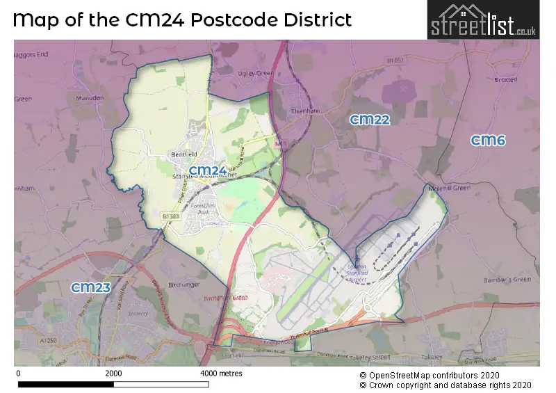
Map of the CM24 Postcode District
Explore the postcode district by using our interactive map.
Circles represent recorded crime; the larger the circle, the higher the crime rates.
Your support helps keep this site running!
If you enjoy using this website, consider buying me a coffee to help cover hosting costs.
Where is the CM24 District?
To give you an idea where the district is located we have created the following table showing nearby towns.
Nearest Towns to CM24
| Town | Distance (miles) | Direction |
|---|---|---|
| Bishop's Stortford | 2.85 | SW |
| Sawbridgeworth | 6.38 | SSW |
| Great Dunmow | 6.69 | ESE |
| Thaxted | 6.86 | NE |
| Saffron Walden | 8.87 | N |
| Harlow | 10.14 | SSW |
| Buntingford | 10.41 | WNW |
| Ware | 12.02 | WSW |
| Chipping Ongar | 13.36 | S |
| Hoddesdon | 13.56 | SW |
| Hertford | 14.17 | WSW |
| Epping | 14.37 | SSW |
| Royston | 14.46 | NW |
| Braintree | 14.62 | E |
| Chelmsford | 15.69 | SE |
| Haverhill | 16.11 | NE |
| Waltham Abbey | 16.77 | SSW |
| Cheshunt | 17.30 | SW |
| Stevenage | 17.69 | W |
The post town for this district is STANSTED.
Postcode Information for District CM24 (Total Geographical Postcodes: 474)
| Location | Post Town | Sector | Number of Postcodes |
|---|---|---|---|
| STANSTED | STANSTED | CM24 8 | 428 |
| London Stansted Airport | STANSTED | CM24 1 | 38 |
| Burton End | STANSTED | CM24 8 | 8 |
Retail and Shopping in CM24
Street
Town
Locality
Number of Shops
Central Postcode
View on Google Maps
LOWER STREET
STANSTED
20
CM24 8LP
View on Google Maps
CAMBRIDGE ROAD
STANSTED
14
CM24 8BZ
View on Google Maps
CHAPEL HILL
STANSTED
6
CM24 8AG
View on Google Maps
STATION ROAD
STANSTED
6
CM24 8BE
View on Google Maps
| Street | Town | Locality | Number of Shops | Central Postcode | View on Google Maps |
|---|---|---|---|---|---|
| LOWER STREET | STANSTED | 20 | CM24 8LP | View on Google Maps | |
| CAMBRIDGE ROAD | STANSTED | 14 | CM24 8BZ | View on Google Maps | |
| CHAPEL HILL | STANSTED | 6 | CM24 8AG | View on Google Maps | |
| STATION ROAD | STANSTED | 6 | CM24 8BE | View on Google Maps |
The primary settlement in the CM24 postcode district is London Stansted Airport, located in the county of Essex. Other significant settlements in the district include Burton End. The main post town in the CM24 district is Stansted.
When it comes to local government, postal geography often disregards political borders. However, this district intersects the following councils: the district mostly encompasses the Uttlesford District area with a total of 273 postal codes.
The largest settlement in the CM24 postal code is STANSTED followed by London Stansted Airport, and Burton End.
The CM24 Postcode shares a border with CM22 (Takeley, Elsenham, Hatfield Heath) and CM23 (BISHOP'S STORTFORD, Birchanger, Manuden).


Dentists in the CM24 District
| # | Name | Address | Type | Contact |
|---|---|---|---|---|
| 1 | Unit 2 Castle Maltings | LOWER STREET , STANSTED , ESSEX , CM24 8XG | GENERAL DENTAL PRACTICE |
Doctors in the CM24 District
| # | Name | Address | Type | Contact |
|---|---|---|---|---|
| 1 | Peacock Surgery | , LOWER STREET , STANSTED , STANSTED , ESSEX , CM24 8XG | GP PRACTICE | |
| 2 | Peacock Surgery - Covid Local Vaccination Service | , LOWER STREET , STANSTED , CM24 8XG | BRANCH SURGERY |
Chemists in the CM24 District
| # | Name | Address | Type | Contact |
|---|---|---|---|---|
| 1 | Peacock Pharmacy | 2 LOWER STREET , STANSTED , CM24 8XG | PHARMACY |
Opticians in the CM24 District
No Opticians found in this district.
Schools in the Sector
Bentfield Primary School and Nursery
Phase: Primary
Address: Rainsford Road , Stansted Mountfitchet , Stansted
Postcode: CM24 8DX
Headteacher: Mr D R Rogers (Headteacher)
Ofsted Rating: Good
St Mary's CofE Foundation Primary School
Phase: Primary
Address: Hampton Road , Stansted
Postcode: CM24 8FE
Headteacher: Mr Matthew Curzon (Headteacher)
Ofsted Rating: Good
Magna Carta Primary Academy
Phase: Primary
Address: St John's Road , Stansted Mountfitchet
Postcode: CM24 8JP
Headteacher: Ms Jennifer Pearce ()
Ofsted Rating: Good
Forest Hall School
Phase: Secondary
Address: Forest Hall Road , Stansted Mountfitchet
Postcode: CM24 8TZ
Headteacher: Mr Dustin Schuyler (Headteacher)
Ofsted Rating: Good
Stations in the Sector
Stansted Airport
CRS Code: SSD
Operator: LE
Line: West Anglia Main Line
Company: Greater Anglia
Stansted Mountfitchet
CRS Code: SST
Operator: LE
Line: West Anglia Main Line
Company: Greater Anglia
Accessable Motorway Junctions
M11 J8
Average Driving Time from within the district: 4.63
Average Driving Distance: 3.07
Number of Postcodes that can access the Motorway Junction: 273
M11 J7A
Average Driving Time from within the district: 10.93
Average Driving Distance: 9.45
Number of Postcodes that can access the Motorway Junction: 273
M11 J7
Average Driving Time from within the district: 13.86
Average Driving Distance: 12.61
Number of Postcodes that can access the Motorway Junction: 273
M11 J6
Average Driving Time from within the district: 17.65
Average Driving Distance: 16.72
Number of Postcodes that can access the Motorway Junction: 37
M11 J10
Average Driving Time from within the district: 21.26
Average Driving Distance: 20.25
Number of Postcodes that can access the Motorway Junction: 236
Weather Forecast for Stansted Mountfitchet
| Time Period | Icon | Description | Temperature | Rain Probability | Wind |
|---|---|---|---|---|---|
| 03:00 to 06:00 | Cloudy | 7.0°C (feels like 3.0°C) | 8.00% | SSW 11 mph | |
| 06:00 to 09:00 | Cloudy | 7.0°C (feels like 3.0°C) | 5.00% | SSW 11 mph | |
| 09:00 to 12:00 | Cloudy | 7.0°C (feels like 4.0°C) | 5.00% | SSW 13 mph | |
| 12:00 to 15:00 | Cloudy | 9.0°C (feels like 6.0°C) | 8.00% | SSW 16 mph | |
| 15:00 to 18:00 | Cloudy | 10.0°C (feels like 6.0°C) | 11.00% | SSW 16 mph | |
| 18:00 to 21:00 | Overcast | 9.0°C (feels like 6.0°C) | 57.00% | SSW 16 mph | |
| 21:00 to 00:00 | Partly cloudy (night) | 8.0°C (feels like 5.0°C) | 16.00% | WSW 9 mph |
| Time Period | Icon | Description | Temperature | Rain Probability | Wind |
|---|---|---|---|---|---|
| 00:00 to 03:00 | Clear night | 6.0°C (feels like 3.0°C) | 2.00% | WSW 9 mph | |
| 03:00 to 06:00 | Clear night | 4.0°C (feels like 1.0°C) | 0.00% | WSW 9 mph | |
| 06:00 to 09:00 | Clear night | 3.0°C (feels like 0.0°C) | 0.00% | WSW 7 mph | |
| 09:00 to 12:00 | Partly cloudy (day) | 4.0°C (feels like 1.0°C) | 1.00% | W 7 mph | |
| 12:00 to 15:00 | Cloudy | 7.0°C (feels like 5.0°C) | 4.00% | WNW 9 mph | |
| 15:00 to 18:00 | Cloudy | 8.0°C (feels like 5.0°C) | 5.00% | NW 7 mph | |
| 18:00 to 21:00 | Cloudy | 4.0°C (feels like 2.0°C) | 4.00% | NW 4 mph | |
| 21:00 to 00:00 | Partly cloudy (night) | 3.0°C (feels like 0.0°C) | 1.00% | NNW 4 mph |
| Time Period | Icon | Description | Temperature | Rain Probability | Wind |
|---|---|---|---|---|---|
| 00:00 to 03:00 | Clear night | 1.0°C (feels like -1.0°C) | 1.00% | N 4 mph | |
| 03:00 to 06:00 | Clear night | 0.0°C (feels like -2.0°C) | 1.00% | NNE 4 mph | |
| 06:00 to 09:00 | Clear night | 0.0°C (feels like -3.0°C) | 0.00% | NNE 4 mph | |
| 09:00 to 12:00 | Sunny day | 2.0°C (feels like -1.0°C) | 1.00% | NE 7 mph | |
| 12:00 to 15:00 | Sunny day | 7.0°C (feels like 4.0°C) | 2.00% | NE 7 mph | |
| 15:00 to 18:00 | Sunny day | 7.0°C (feels like 5.0°C) | 1.00% | ENE 9 mph | |
| 18:00 to 21:00 | Clear night | 4.0°C (feels like 1.0°C) | 2.00% | NE 7 mph | |
| 21:00 to 00:00 | Clear night | 2.0°C (feels like -1.0°C) | 2.00% | NE 7 mph |
| Time Period | Icon | Description | Temperature | Rain Probability | Wind |
|---|---|---|---|---|---|
| 00:00 to 03:00 | Clear night | 2.0°C (feels like -1.0°C) | 2.00% | NE 7 mph | |
| 03:00 to 06:00 | Partly cloudy (night) | 2.0°C (feels like -2.0°C) | 2.00% | NE 9 mph | |
| 06:00 to 09:00 | Cloudy | 2.0°C (feels like -2.0°C) | 6.00% | NE 9 mph | |
| 09:00 to 12:00 | Cloudy | 3.0°C (feels like -1.0°C) | 6.00% | NE 9 mph | |
| 12:00 to 15:00 | Partly cloudy (day) | 5.0°C (feels like 2.0°C) | 3.00% | NE 11 mph | |
| 15:00 to 18:00 | Partly cloudy (day) | 5.0°C (feels like 2.0°C) | 2.00% | NE 11 mph | |
| 18:00 to 21:00 | Clear night | 3.0°C (feels like 0.0°C) | 2.00% | NE 9 mph | |
| 21:00 to 00:00 | Overcast | 2.0°C (feels like -1.0°C) | 8.00% | NE 7 mph |
| Postal Sector | Delivery Office |
|---|---|
| CM24 1 | Stansted Scale Payment Delivery Office |
| CM24 1 | Bishops Stortford Delivery Office |
| CM24 2 | Bishops Stortford Delivery Office |
| CM24 3 | Bishops Stortford Delivery Office |
| CM24 4 | Bishops Stortford Delivery Office |
| CM24 5 | Bishops Stortford Delivery Office |
| CM24 6 | Bishops Stortford Delivery Office |
| CM24 7 | Bishops Stortford Delivery Office |
| CM24 8 | Bishops Stortford Delivery Office |
| CM24 9 | Bishops Stortford Delivery Office |
| CM24 8 | Stansted Scale Payment Delivery Office |
| C | M | 2 | 4 | - | X | X | X |
| C | M | 2 | 4 | Space | Numeric | Letter | Letter |
Street List for the CM24 District
Current Monthly Rental Prices
| # Bedrooms | Min Price | Max Price | Avg Price |
|---|---|---|---|
| 2 | £1,200 | £1,200 | £1,200 |
| 3 | £1,650 | £1,650 | £1,650 |
| 4 | £1,950 | £2,000 | £1,982 |
| 5 | £2,350 | £2,350 | £2,350 |
Current House Prices
| # Bedrooms | Min Price | Max Price | Avg Price |
|---|---|---|---|
| 4 | £600,000 | £1,650,000 | £800,769 |
| 5 | £600,000 | £875,000 | £695,455 |
| 12 | £3,450,000 | £3,450,000 | £3,450,000 |
Estate Agents
| Logo | Name | Brand Name | Address | Contact Number |
|---|---|---|---|---|
 | Stansted | Intercounty | 8 Cambridge Road, Stansted, CM24 8BZ | 01279 594576 |
 | Stansted Mountfitchet | Russell Property | Castle Maltings Lower Street, Stansted, CM24 8LP | 01279 976902 |
 | Stansted | Murdochs Property Shop | 1 Station Road, Stansted, CM24 8BE | 01279 813318 |
 | Little Hadham | David Lee Head Office | 13E Church End Farm Church End Little Hadham SG11 2DY | 020 3907 3367 |
 | Bishop's Stortford | Mullucks | The Guild House, Water Lane, Bishop's Stortford, CM23 2JZ | 01279 594679 |
Yearly House Price Averages for the District
| Type of Property | 2018 Average | 2018 Sales | 2017 Average | 2017 Sales | 2016 Average | 2016 Sales | 2015 Average | 2015 Sales |
|---|---|---|---|---|---|---|---|---|
| Detached | £560,044 | 91 | £531,954 | 48 | £596,813 | 40 | £552,699 | 55 |
| Semi-Detached | £439,923 | 49 | £456,134 | 41 | £386,426 | 34 | £376,750 | 32 |
| Terraced | £350,480 | 52 | £327,429 | 42 | £316,891 | 55 | £289,438 | 75 |
| Flats | £232,192 | 13 | £242,342 | 18 | £211,890 | 25 | £182,976 | 21 |