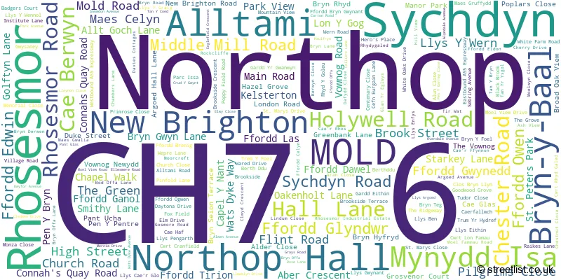
A wide range of spatial data has been analysed to present this overview of the CH7 6 Postcode sector. If you would like anything added, please contact us.
The CH7 6 postcode sector is within the county of Clwyd.
Did you know? According to the 2021 Census, the CH7 6 postcode sector is home to a bustling 11,662 residents!
Given that each sector allows for 400 unique postcode combinations. Letters C, I, K, M, O and V are not allowed in the last two letters of a postcode. With 354 postcodes already in use, this leaves 46 units available.
The largest settlement in the CH7 6 postal code is MYNYDD ISA followed by NORTHOP HALL, and NORTHOP.
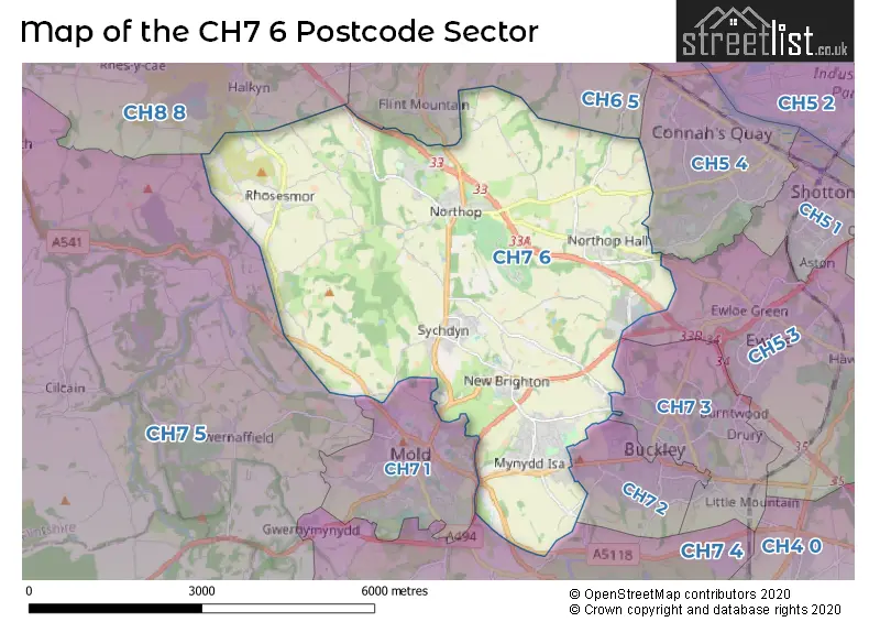
The CH7 6 Postcode shares a border with CH7 4 (LEESWOOD, TREUDDYN, LLANARMON YN IAL), CH7 5 (CAERWYS, Gwernaffield, CILCAIN), CH8 8 (Pentre Halkyn, CARMEL, BRYNFORD), CH5 3 (Hawarden, Ewloe, DOBSHILL), CH5 4 (Connah's Quay, CONNAHS QUAY), CH6 5 (FLINT, OAKENHOLT, FLINT MOUNTAIN), CH7 1 (MOLD), CH7 2 (BUCKLEY) and CH7 3 (BUCKLEY, DRURY, BURNTWOOD).
Map of the CH7 6 Postcode Sector
Explore the CH7 6 postcode sector by using our interactive map.
The sector is within the post town of MOLD.
CH7 6 is a postcode sector within the CH7 postcode district which is within the CH Chester postcode area.
The Royal Mail delivery office for the CH7 6 postal sector is the Mold Delivery Office.
The area of the CH7 6 postcode sector is 14.18 square miles which is 36.73 square kilometres or 9,076.41 square acres.
Your support helps keep this site running!
If you enjoy using this website, consider buying me a coffee to help cover hosting costs.


| C | H | 7 | - | 6 | X | X |
| C | H | 7 | Space | 6 | Letter | Letter |
Official List of Streets
Northop (38 Streets)
Alltami (10 Streets)
New Brighton (16 Streets)
Sychdyn (44 Streets)
Northop Hall (41 Streets)
Bryn-y-Baal (28 Streets)
Mynydd Isa (59 Streets)
Rhosesmor (14 Streets)
(1 Streets)
Unofficial Streets or Alternative Spellings
Ewloe
MAGAZINE LANE STAMFORD WAY ALLT-GOCH LANE ARGOED VIEW BROCK STREET BRON-YR-EGLWYS BRYN-GWYN LANE BRYN-Y-BAAL ROAD BRYN-Y-FOEL CLOS BRYN ILYN CLOS LINDUM CRUD-Y-GWYNT DANGEROUS CROSSING DOLWEN COURT DRIVE THRU EAST VIEW FFORD ELDON FFORD GANOL FFORD TIRION FFORDD ROWLAND FLAT LANE GARDD-Y-GWANWYN GWIBFFORDD GOGLEDD CYMRU / NORTH WALES EXPRESSWAY KELSTERTON LANE LLYS Y CRAIG LLYS-Y-WERN MAES Y GLOWYR MOLD BYPASS MOOR CROFT NORTHOP INTERCHANGE OAKFIELDS PEN-Y-BRYN PEN-Y-GARREG CLOSE PEN-Y-LON PEN-Y-PENTRE PENTRE MOCH PENYMAES SAINT MARYS DRIVE SAINT PETERS PARK TAN-Y-BRYN TAN-Y-COED TAN-YR-YSGOL THE CEDARS THE GROVES TREM-Y-FOEL TRUM-YR-HYDREF UWCH-Y-NANT VOWNOG WYLFA ROUNDABOUTBUCKLEY
WELL STREETFlint Mountain
NORTHOP ROADConnah's Quay
GOLFTYN LANE MOLD ROAD WEPRE LANEWeather Forecast for CH7 6
Weather Forecast for Mold
| Time Period | Icon | Description | Temperature | Rain Probability | Wind |
|---|---|---|---|---|---|
| 09:00 to 12:00 | Overcast | 6.0°C (feels like 3.0°C) | 11.00% | WNW 11 mph | |
| 12:00 to 15:00 | Cloudy | 7.0°C (feels like 4.0°C) | 6.00% | NW 9 mph | |
| 15:00 to 18:00 | Cloudy | 7.0°C (feels like 5.0°C) | 5.00% | NNW 7 mph | |
| 18:00 to 21:00 | Cloudy | 4.0°C (feels like 3.0°C) | 5.00% | W 2 mph | |
| 21:00 to 00:00 | Cloudy | 3.0°C (feels like 2.0°C) | 6.00% | SSW 4 mph |
| Time Period | Icon | Description | Temperature | Rain Probability | Wind |
|---|---|---|---|---|---|
| 00:00 to 03:00 | Cloudy | 2.0°C (feels like 0.0°C) | 16.00% | SSW 4 mph | |
| 03:00 to 06:00 | Cloudy | 2.0°C (feels like -1.0°C) | 8.00% | S 4 mph | |
| 06:00 to 09:00 | Overcast | 2.0°C (feels like -1.0°C) | 10.00% | SSE 7 mph | |
| 09:00 to 12:00 | Cloudy | 3.0°C (feels like 0.0°C) | 6.00% | SSE 7 mph | |
| 12:00 to 15:00 | Cloudy | 6.0°C (feels like 2.0°C) | 7.00% | SSE 11 mph | |
| 15:00 to 18:00 | Cloudy | 6.0°C (feels like 3.0°C) | 7.00% | SSE 11 mph | |
| 18:00 to 21:00 | Cloudy | 5.0°C (feels like 2.0°C) | 7.00% | SSE 9 mph | |
| 21:00 to 00:00 | Cloudy | 5.0°C (feels like 1.0°C) | 6.00% | SSE 11 mph |
| Time Period | Icon | Description | Temperature | Rain Probability | Wind |
|---|---|---|---|---|---|
| 00:00 to 03:00 | Cloudy | 5.0°C (feels like 1.0°C) | 7.00% | SSE 13 mph | |
| 03:00 to 06:00 | Cloudy | 5.0°C (feels like 1.0°C) | 11.00% | S 11 mph | |
| 06:00 to 09:00 | Cloudy | 5.0°C (feels like 1.0°C) | 20.00% | S 11 mph | |
| 09:00 to 12:00 | Cloudy | 5.0°C (feels like 2.0°C) | 17.00% | SSW 9 mph | |
| 12:00 to 15:00 | Cloudy | 7.0°C (feels like 4.0°C) | 12.00% | SW 9 mph | |
| 15:00 to 18:00 | Overcast | 7.0°C (feels like 6.0°C) | 12.00% | SW 7 mph | |
| 18:00 to 21:00 | Cloudy | 5.0°C (feels like 3.0°C) | 5.00% | SW 7 mph | |
| 21:00 to 00:00 | Partly cloudy (night) | 4.0°C (feels like 2.0°C) | 2.00% | SSW 7 mph |
| Time Period | Icon | Description | Temperature | Rain Probability | Wind |
|---|---|---|---|---|---|
| 00:00 to 03:00 | Cloudy | 3.0°C (feels like 1.0°C) | 5.00% | SSW 4 mph | |
| 03:00 to 06:00 | Cloudy | 3.0°C (feels like 1.0°C) | 5.00% | SSW 7 mph | |
| 06:00 to 09:00 | Cloudy | 3.0°C (feels like 0.0°C) | 5.00% | S 7 mph | |
| 09:00 to 12:00 | Cloudy | 4.0°C (feels like 1.0°C) | 5.00% | S 7 mph | |
| 12:00 to 15:00 | Cloudy | 8.0°C (feels like 5.0°C) | 5.00% | S 11 mph | |
| 15:00 to 18:00 | Cloudy | 9.0°C (feels like 6.0°C) | 5.00% | S 11 mph | |
| 18:00 to 21:00 | Cloudy | 7.0°C (feels like 4.0°C) | 5.00% | S 11 mph | |
| 21:00 to 00:00 | Cloudy | 7.0°C (feels like 3.0°C) | 6.00% | S 13 mph |

House Prices in the CH7 6 Postcode Sector
| Type of Property | 2018 Average | 2018 Sales | 2017 Average | 2017 Sales | 2016 Average | 2016 Sales | 2015 Average | 2015 Sales |
|---|---|---|---|---|---|---|---|---|
| Detached | £252,380 | 124 | £254,580 | 104 | £231,567 | 120 | £237,381 | 94 |
| Semi-Detached | £165,509 | 74 | £166,529 | 49 | £148,749 | 50 | £147,118 | 60 |
| Terraced | £147,010 | 29 | £155,471 | 17 | £141,097 | 15 | £137,764 | 18 |
| Flats | £142,000 | 1 | £139,833 | 6 | £0 | 0 | £160,000 | 2 |
Important Postcodes CH7 6 in the Postcode Sector
CH7 6AA is the postcode for LIFE SKILLS PRACTICAL WORKSHOP, Coleg Cambria, Holywell Road, Mitchelmore Building, Glyndwr University, ADMINISTRATION BLOCK, Coleg Cambria, Holywell Road, LEARNING CENTRE, Coleg Cambria, Holywell Road, THE BUSINESS MANAGEMENT CENTRE, Coleg Cambria, Holywell Road, MAIN BLOCK, Coleg Cambria, Holywell Road, LIFE SKILLS BUILDING, Coleg Cambria, Holywell Road, Corbishley Building, Glyndwr University, SMALL ANIMAL UNIT, Coleg Cambria, Holywell Road, and Welsh College of Horticulture, Holywell Road
CH7 6AU is the postcode for Ysgol Owen Jones, Ffordd Owen
CH7 6ED is the postcode for Sychdyn Cp School, Vownog Road
CH7 6HS is the postcode for Northop Hall Cp School, Llys Ben, Village Road
CH7 6NB is the postcode for Flintshire County Council, County Hall,
CH7 6NW is the postcode for Flintshire County Council, County Hall,
CH7 6PJ is the postcode for Rhos Helyg Cp School, Village Road,
CH7 6QX is the postcode for New Brighton Community Centre, Moel Fammau Road
CH7 6RY is the postcode for Argoed High School, Bryn Road
CH7 6SJ is the postcode for Mynydd Isa Cp Junior School, Chambers Lane
CH7 6UH is the postcode for Flintshire County Council, Mynydd Isa Library Community Centre, Mercia Drive
CH7 6UL is the postcode for Wats Dyke Infant School, Wats Dyke Avenue
| The CH7 6 Sector is within these Local Authorities |
|
|---|---|
| The CH7 6 Sector is within these Counties |
|
| The CH7 6 Sector is within these Water Company Areas |
|