A wide range of spatial data has been analysed to present this overview of the CH5 1 Postcode sector. If you would like anything added, please contact us.
The CH5 1 postcode sector is within the county of Clwyd.
Did you know? According to the 2021 Census, the CH5 1 postcode sector is home to a bustling 8,172 residents!
Given that each sector allows for 400 unique postcode combinations. Letters C, I, K, M, O and V are not allowed in the last two letters of a postcode. With 209 postcodes already in use, this leaves 191 units available.
The largest settlements in the CH5 1 postal code are Shotton and Queensferry.
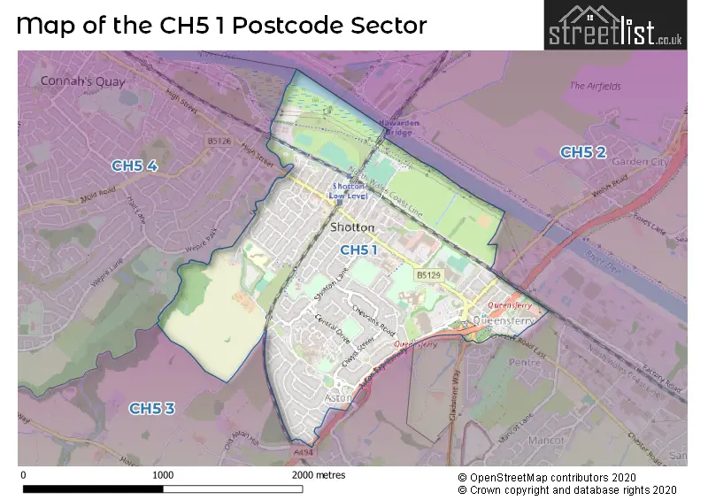
The CH5 1 Postcode shares a border with CH5 2 (SEALAND, Mancot, SANDYCROFT), CH5 3 (Hawarden, Ewloe, DOBSHILL) and CH5 4 (Connah's Quay, CONNAHS QUAY).
Map of the CH5 1 Postcode Sector
Explore the CH5 1 postcode sector by using our interactive map.
The sector is within the post town of DEESIDE.
CH5 1 is a postcode sector within the CH5 postcode district which is within the CH Chester postcode area.
The Royal Mail delivery office for the CH5 1 postal sector is the Deeside Delivery Office.
The area of the CH5 1 postcode sector is 1.33 square miles which is 3.43 square kilometres or 848.61 square acres.
Your support helps keep this site running!
If you enjoy using this website, consider buying me a coffee to help cover hosting costs.


| C | H | 5 | - | 1 | X | X |
| C | H | 5 | Space | 1 | Letter | Letter |
Official List of Streets
Queensferry (29 Streets)
Shotton (101 Streets)
DEESIDE (1 Streets)
Unofficial Streets or Alternative Spellings
Ewloe
ASTON HILLPentre
FFORDD PENTREConnah's Quay
HIGH STREETAston
THE CROFTWeather Forecast for CH5 1
Weather Forecast for Shotton
| Time Period | Icon | Description | Temperature | Rain Probability | Wind |
|---|---|---|---|---|---|
| 09:00 to 12:00 | Partly cloudy (day) | 3.0°C (feels like 0.0°C) | 1.00% | SSE 9 mph | |
| 12:00 to 15:00 | Partly cloudy (day) | 6.0°C (feels like 2.0°C) | 1.00% | SSE 11 mph | |
| 15:00 to 18:00 | Cloudy | 7.0°C (feels like 4.0°C) | 4.00% | SSE 11 mph | |
| 18:00 to 21:00 | Cloudy | 5.0°C (feels like 2.0°C) | 5.00% | SSE 9 mph | |
| 21:00 to 00:00 | Cloudy | 5.0°C (feels like 1.0°C) | 5.00% | SSE 11 mph |
| Time Period | Icon | Description | Temperature | Rain Probability | Wind |
|---|---|---|---|---|---|
| 00:00 to 03:00 | Cloudy | 5.0°C (feels like 1.0°C) | 6.00% | SSE 13 mph | |
| 03:00 to 06:00 | Cloudy | 4.0°C (feels like 0.0°C) | 6.00% | SSE 11 mph | |
| 06:00 to 09:00 | Cloudy | 4.0°C (feels like 1.0°C) | 8.00% | SSE 11 mph | |
| 09:00 to 12:00 | Overcast | 4.0°C (feels like 1.0°C) | 11.00% | SSE 9 mph | |
| 12:00 to 15:00 | Overcast | 6.0°C (feels like 3.0°C) | 12.00% | S 9 mph | |
| 15:00 to 18:00 | Cloudy | 7.0°C (feels like 5.0°C) | 11.00% | S 7 mph | |
| 18:00 to 21:00 | Overcast | 6.0°C (feels like 4.0°C) | 8.00% | S 7 mph | |
| 21:00 to 00:00 | Cloudy | 5.0°C (feels like 3.0°C) | 5.00% | S 7 mph |
| Time Period | Icon | Description | Temperature | Rain Probability | Wind |
|---|---|---|---|---|---|
| 00:00 to 03:00 | Cloudy | 4.0°C (feels like 2.0°C) | 5.00% | S 7 mph | |
| 03:00 to 06:00 | Cloudy | 4.0°C (feels like 1.0°C) | 5.00% | S 7 mph | |
| 06:00 to 09:00 | Cloudy | 4.0°C (feels like 1.0°C) | 5.00% | SSE 7 mph | |
| 09:00 to 12:00 | Cloudy | 5.0°C (feels like 2.0°C) | 5.00% | SSE 9 mph | |
| 12:00 to 15:00 | Cloudy | 8.0°C (feels like 6.0°C) | 5.00% | S 11 mph | |
| 15:00 to 18:00 | Cloudy | 10.0°C (feels like 7.0°C) | 4.00% | S 11 mph | |
| 18:00 to 21:00 | Partly cloudy (night) | 8.0°C (feels like 5.0°C) | 3.00% | S 11 mph | |
| 21:00 to 00:00 | Partly cloudy (night) | 7.0°C (feels like 4.0°C) | 4.00% | S 11 mph |
| Time Period | Icon | Description | Temperature | Rain Probability | Wind |
|---|---|---|---|---|---|
| 00:00 to 03:00 | Cloudy | 8.0°C (feels like 5.0°C) | 10.00% | S 13 mph | |
| 03:00 to 06:00 | Cloudy | 8.0°C (feels like 5.0°C) | 14.00% | S 13 mph | |
| 06:00 to 09:00 | Cloudy | 8.0°C (feels like 5.0°C) | 15.00% | S 11 mph | |
| 09:00 to 12:00 | Cloudy | 8.0°C (feels like 6.0°C) | 15.00% | SSW 11 mph | |
| 12:00 to 15:00 | Cloudy | 10.0°C (feels like 7.0°C) | 16.00% | SW 11 mph | |
| 15:00 to 18:00 | Cloudy | 10.0°C (feels like 7.0°C) | 12.00% | SW 11 mph | |
| 18:00 to 21:00 | Partly cloudy (night) | 7.0°C (feels like 5.0°C) | 6.00% | SW 9 mph | |
| 21:00 to 00:00 | Clear night | 7.0°C (feels like 4.0°C) | 2.00% | WSW 9 mph |
House Prices in the CH5 1 Postcode Sector
| Type of Property | 2018 Average | 2018 Sales | 2017 Average | 2017 Sales | 2016 Average | 2016 Sales | 2015 Average | 2015 Sales |
|---|---|---|---|---|---|---|---|---|
| Detached | £174,225 | 20 | £163,297 | 20 | £142,854 | 25 | £151,534 | 18 |
| Semi-Detached | £125,091 | 44 | £122,217 | 40 | £127,306 | 47 | £119,038 | 32 |
| Terraced | £105,728 | 39 | £96,903 | 37 | £99,762 | 29 | £93,491 | 33 |
| Flats | £71,667 | 3 | £60,167 | 6 | £61,000 | 2 | £59,000 | 1 |
Important Postcodes CH5 1 in the Postcode Sector
CH5 1AG is the postcode for 30, Ash Grove, Shotton
CH5 1AS is the postcode for Edward Morgan School, Caernarvon Close
CH5 1BY is the postcode for Wetherspoons, 28 Chester Road West
CH5 1HP is the postcode for Ysgol Ty Ffynnon Well House Primary School, Taliesin Avenue, and Taliesin Junior School, Taliesin Avenue
CH5 1JD is the postcode for Shotton Infants School, Plymouth Street
CH5 1NF is the postcode for Aston Nursery School, Larch Avenue
CH5 1NG is the postcode for St. Ethelwolds V P School, Melrose Avenue
CH5 1PU is the postcode for Community Drug & Alcohol Team, Rowleys Drive
CH5 1SA is the postcode for Deeside Leisure Centre, Chester Road West, and Glanrafon Training Centre, Chester Road West
CH5 1SE is the postcode for John Summers High School, Chester Road West
CH5 1SX is the postcode for 46, Station Road, Queensferry
CH5 1TF is the postcode for Queensferry County Primary School, Queensferry Campus, Mold Road
CH5 1XS is the postcode for Deeside Community Hospital, Plough Lane
| The CH5 1 Sector is within these Local Authorities |
|
|---|---|
| The CH5 1 Sector is within these Counties |
|
| The CH5 1 Sector is within these Water Company Areas |
|