A wide range of spatial data has been analysed to present this overview of the CA19 1 Postcode sector. If you would like anything added, please contact us.
The CA19 1 Holmrook Postcode Sector
The CA19 1 postcode sector is within the county of Cumbria.
Did you know? According to the 2021 Census, the CA19 1 postcode sector is home to a bustling 933 residents!
Given that each sector allows for 400 unique postcode combinations. Letters C, I, K, M, O and V are not allowed in the last two letters of a postcode. With 67 postcodes already in use, this leaves 333 units available.
The largest settlement in the CA19 1 postal code is Drigg followed by Eskdale, and HOLMROOK.
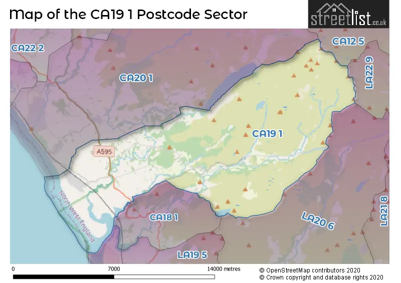
The CA19 1 Postcode shares a border with CA12 5 (KESWICK, Braithwaite, Portinscale), CA18 1 (RAVENGLASS, Muncaster, Broad Oak), CA20 1 (SEASCALE, Gosforth, Calderbridge), LA20 6 (BROUGHTON-IN-FURNESS, Ulpha, Seathwaite) and LA22 9 (AMBLESIDE, Grasmere, Chapel Stile).
Map of the CA19 1 Postcode Sector
Explore the CA19 1 postcode sector by using our interactive map.
The sector is within the post town of HOLMROOK.
CA19 1 is a postcode sector within the CA19 postcode district which is within the CA Carlisle postcode area.
The Royal Mail delivery office for the CA19 1 postal sector is the Seascale Scale Payment Delivery Office.
The area of the CA19 1 postcode sector is 50.91 square miles which is 131.85 square kilometres or 32,581.29 square acres.
Waterways within the CA19 1 postcode sector include the River Esk, River Bleng, River Mite, Whillan Beck.
Your support helps keep this site running!
If you enjoy using this website, consider buying me a coffee to help cover hosting costs.


| C | A | 1 | 9 | - | 1 | X | X |
| C | A | 1 | 9 | Space | 1 | Letter | Letter |
Official List of Streets
(12 Streets)
HOLMROOK (3 Streets)
Drigg (7 Streets)
Eskdale (2 Streets)
Santon (1 Streets)
Unofficial Streets or Alternative Spellings
Weather Forecast for CA19 1
Weather Forecast for Eskdale Youth Hostel
| Time Period | Icon | Description | Temperature | Rain Probability | Wind |
|---|---|---|---|---|---|
| 15:00 to 18:00 | Cloudy | 4.0°C (feels like 0.0°C) | 6.00% | ESE 11 mph | |
| 18:00 to 21:00 | Cloudy | 3.0°C (feels like -1.0°C) | 6.00% | ESE 13 mph | |
| 21:00 to 00:00 | Cloudy | 3.0°C (feels like -1.0°C) | 8.00% | ESE 13 mph |
| Time Period | Icon | Description | Temperature | Rain Probability | Wind |
|---|---|---|---|---|---|
| 00:00 to 03:00 | Cloudy | 3.0°C (feels like -2.0°C) | 13.00% | ESE 13 mph | |
| 03:00 to 06:00 | Cloudy | 3.0°C (feels like -1.0°C) | 18.00% | ESE 11 mph | |
| 06:00 to 09:00 | Cloudy | 3.0°C (feels like 0.0°C) | 15.00% | ESE 9 mph | |
| 09:00 to 12:00 | Cloudy | 4.0°C (feels like 0.0°C) | 13.00% | ESE 9 mph | |
| 12:00 to 15:00 | Cloudy | 5.0°C (feels like 1.0°C) | 11.00% | E 11 mph | |
| 15:00 to 18:00 | Cloudy | 6.0°C (feels like 3.0°C) | 9.00% | E 11 mph | |
| 18:00 to 21:00 | Cloudy | 5.0°C (feels like 2.0°C) | 8.00% | ESE 9 mph | |
| 21:00 to 00:00 | Cloudy | 5.0°C (feels like 1.0°C) | 8.00% | ESE 11 mph |
| Time Period | Icon | Description | Temperature | Rain Probability | Wind |
|---|---|---|---|---|---|
| 00:00 to 03:00 | Cloudy | 5.0°C (feels like 1.0°C) | 9.00% | ESE 13 mph | |
| 03:00 to 06:00 | Cloudy | 5.0°C (feels like 1.0°C) | 10.00% | ESE 11 mph | |
| 06:00 to 09:00 | Cloudy | 5.0°C (feels like 1.0°C) | 10.00% | ESE 11 mph | |
| 09:00 to 12:00 | Cloudy | 6.0°C (feels like 2.0°C) | 7.00% | ESE 11 mph | |
| 12:00 to 15:00 | Cloudy | 8.0°C (feels like 5.0°C) | 7.00% | ESE 11 mph | |
| 15:00 to 18:00 | Cloudy | 8.0°C (feels like 6.0°C) | 6.00% | SE 13 mph | |
| 18:00 to 21:00 | Overcast | 8.0°C (feels like 5.0°C) | 12.00% | SSE 16 mph | |
| 21:00 to 00:00 | Cloudy | 8.0°C (feels like 4.0°C) | 11.00% | SSE 18 mph |
| Time Period | Icon | Description | Temperature | Rain Probability | Wind |
|---|---|---|---|---|---|
| 00:00 to 03:00 | Cloudy | 9.0°C (feels like 5.0°C) | 12.00% | SSE 20 mph | |
| 03:00 to 06:00 | Overcast | 9.0°C (feels like 5.0°C) | 14.00% | S 20 mph | |
| 06:00 to 09:00 | Overcast | 9.0°C (feels like 5.0°C) | 18.00% | S 22 mph | |
| 09:00 to 12:00 | Overcast | 9.0°C (feels like 5.0°C) | 20.00% | S 22 mph | |
| 12:00 to 15:00 | Overcast | 10.0°C (feels like 6.0°C) | 25.00% | S 25 mph | |
| 15:00 to 18:00 | Light rain | 11.0°C (feels like 7.0°C) | 50.00% | S 25 mph | |
| 18:00 to 21:00 | Overcast | 10.0°C (feels like 6.0°C) | 20.00% | S 22 mph | |
| 21:00 to 00:00 | Overcast | 10.0°C (feels like 6.0°C) | 18.00% | S 22 mph |
Schools and Places of Education Within the CA19 1 Postcode Sector
St Bega's CofE Primary School
Voluntary aided school
Longrigg Lane, Holmrook, Cumbria, CA19 1TW
Head: Mrs Elizabeth Stellmacher
Ofsted Rating: Good
Inspection: 2020-03-03 (1812 days ago)
Website: Visit St Bega's CofE Primary School Website
Phone: 01946723259
Number of Pupils: 25
House Prices in the CA19 1 Postcode Sector
| Type of Property | 2018 Average | 2018 Sales | 2017 Average | 2017 Sales | 2016 Average | 2016 Sales | 2015 Average | 2015 Sales |
|---|---|---|---|---|---|---|---|---|
| Detached | £327,186 | 7 | £298,417 | 6 | £275,000 | 6 | £193,000 | 5 |
| Semi-Detached | £226,000 | 2 | £0 | 0 | £0 | 0 | £177,500 | 4 |
| Terraced | £173,300 | 5 | £140,333 | 3 | £197,667 | 3 | £152,488 | 4 |
| Flats | £0 | 0 | £0 | 0 | £0 | 0 | £0 | 0 |
Important Postcodes CA19 1 in the Postcode Sector
CA19 1TW is the postcode for St. Begas C of E School, Eskdale
| The CA19 1 Sector is within these Local Authorities |
|
|---|---|
| The CA19 1 Sector is within these Counties |
|
| The CA19 1 Sector is within these Water Company Areas |
|