
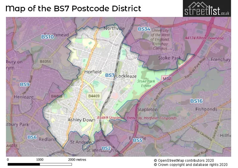
Map of the BS7 Postcode District
Explore the postcode district by using our interactive map.
Circles represent recorded crime; the larger the circle, the higher the crime rates.
Your support helps keep this site running!
If you enjoy using this website, consider buying me a coffee to help cover hosting costs.
Where is the BS7 District?
To give you an idea where the district is located we have created the following table showing nearby towns.
Nearest Towns to BS7
| Town | Distance (miles) | Direction |
|---|---|---|
| Filton | 1.56 | N |
| Bristol | 2.65 | SSW |
| Bradley Stoke | 3.44 | NNE |
| Keynsham | 6.01 | SE |
| Yate | 7.69 | ENE |
| Portishead | 8.27 | W |
| Chipping Sodbury | 8.62 | ENE |
| Thornbury | 8.65 | NNE |
| Nailsea | 8.72 | WSW |
| Caldicot | 10.36 | NW |
| Chepstow | 11.40 | NNW |
| Bath | 11.89 | SE |
| Clevedon | 12.41 | WSW |
| Wotton-under-Edge | 14.16 | NE |
| Midsomer Norton | 14.59 | SSE |
| Radstock | 14.66 | SSE |
| Dursley | 16.44 | NE |
| Lydney | 16.57 | N |
| Bradford-on-Avon | 17.16 | SE |
| Corsham | 17.35 | ESE |
The post town for this district is BRISTOL.
Postcode Information for District BS7 (Total Geographical Postcodes: 1404)
| Location | Post Town | Sector | Number of Postcodes |
|---|---|---|---|
| BRISTOL | BRISTOL | BS7 0 | 380 |
| BRISTOL | BRISTOL | BS7 9 | 353 |
| BRISTOL | BRISTOL | BS7 8 | 231 |
| Horfield | BRISTOL | BS7 0 | 152 |
| Bishopston | BRISTOL | BS7 8 | 113 |
| Horfield | BRISTOL | BS7 8 | 63 |
| Horfield | BRISTOL | BS7 9 | 47 |
| Bishopston | BRISTOL | BS7 9 | 41 |
| Ashley Down | BRISTOL | BS7 9 | 20 |
| Northville | BRISTOL | BS7 0 | 2 |
| St. Andrews | BRISTOL | BS7 9 | 2 |
Retail and Shopping in BS7
Street
Town
Locality
Number of Shops
Central Postcode
View on Google Maps
GLOUCESTER ROAD
BRISTOL
BISHOPSTON
309
BS7 8NT
View on Google Maps
FILTON AVENUE
BRISTOL
HORFIELD
35
BS7 0BD
View on Google Maps
GLOUCESTER ROAD NORTH
BRISTOL
FILTON
32
BS7 0SF
View on Google Maps
FILTON ROAD
BRISTOL
HORFIELD
31
BS7 0PB
View on Google Maps
GLOUCESTER ROAD
BRISTOL
HORFIELD
19
BS7 8TP
View on Google Maps
FILTON AVENUE
BRISTOL
FILTON
17
BS7 0QE
View on Google Maps
ASHLEY DOWN ROAD
BRISTOL
14
BS7 9JT
View on Google Maps
GAINSBOROUGH SQUARE
BRISTOL
12
BS7 9XA
View on Google Maps
MULLER ROAD
BRISTOL
HORFIELD
10
BS7 0AB
View on Google Maps
| Street | Town | Locality | Number of Shops | Central Postcode | View on Google Maps |
|---|---|---|---|---|---|
| GLOUCESTER ROAD | BRISTOL | BISHOPSTON | 309 | BS7 8NT | View on Google Maps |
| FILTON AVENUE | BRISTOL | HORFIELD | 35 | BS7 0BD | View on Google Maps |
| GLOUCESTER ROAD NORTH | BRISTOL | FILTON | 32 | BS7 0SF | View on Google Maps |
| FILTON ROAD | BRISTOL | HORFIELD | 31 | BS7 0PB | View on Google Maps |
| GLOUCESTER ROAD | BRISTOL | HORFIELD | 19 | BS7 8TP | View on Google Maps |
| FILTON AVENUE | BRISTOL | FILTON | 17 | BS7 0QE | View on Google Maps |
| ASHLEY DOWN ROAD | BRISTOL | 14 | BS7 9JT | View on Google Maps | |
| GAINSBOROUGH SQUARE | BRISTOL | 12 | BS7 9XA | View on Google Maps | |
| MULLER ROAD | BRISTOL | HORFIELD | 10 | BS7 0AB | View on Google Maps |
The primary settlement in the BS7 postcode district is Bristol, which is located in the county of Gloucestershire in England. Other significant settlements in this postcode district include Horfield and Bishopston. The main post town in this district is Bristol.
When it comes to local government, postal geography often disregards political borders. However, this district intersects the following councils: the district mostly encompasses the City of Bristol (B) (716 postal codes), and finally, the South Gloucestershire area (63 postal codes).
The largest settlement in the BS7 postal code is BRISTOL followed by Horfield, and Bishopston.
The BS7 Postcode shares a border with BS5 (BRISTOL, St. George, Eastville), BS6 (BRISTOL, St. Andrews, Redland), BS16 (BRISTOL, Emersons Green, Mangotsfield), BS2 (BRISTOL, St. Philips, St. Pauls), BS34 (Patchway, Stoke Gifford, Filton) and BS10 (BRISTOL, Westbury-on-Trym, Henbury).


Dentists in the BS7 District
| # | Name | Address | Type | Contact |
|---|---|---|---|---|
| 1 | Ashley Down Dental Care | 382 GLOUCESTER ROAD , HORFIELD , BRISTOL , AVON , BS7 8TR | GENERAL DENTAL PRACTICE | |
| 2 | Oasis Dental Care Ltd | 229-231 GLOUCESTER ROAD , BISHOPSTON , BRISTOL , AVON , BS7 8NR | GENERAL DENTAL PRACTICE | |
| 3 | Horfield Dental Surgery | 525 GLOUCESTER ROAD , HORFIELD , BRISTOL , AVON , BS7 8UG | GENERAL DENTAL PRACTICE | |
| 4 | Time For Teeth Hmp Bristol | H M PRISON , CAMBRIDGE ROAD , BRISTOL , AVON , BS7 8PS | GENERAL DENTAL PRACTICE | |
| 5 | Promenade Dental Practice | 10-12 GLOUCESTER ROAD , BISHOPSTON , BRISTOL , AVON , BS7 8AE | GENERAL DENTAL PRACTICE | |
| 6 | Monks Park Dental Care | 94-96 FILTON ROAD , HORFIELD , BRISTOL , AVON , BS7 0PD | GENERAL DENTAL PRACTICE | |
| 7 | Montreal Avenue Dental Practice | 130 MONTREAL AVENUE , BRISTOL , AVON , BS7 0NQ | GENERAL DENTAL PRACTICE | |
| 8 | 371 Filton Avenue [dental Practice] | 371 FILTON AVENUE , HORFIELD , BRISTOL , AVON , BS7 0BD | GENERAL DENTAL PRACTICE |
Doctors in the BS7 District
| # | Name | Address | Type | Contact |
|---|---|---|---|---|
| 1 | Horfield Hc | , BRISTOL , BS7 9RR | GP PRACTICE | |
| 2 | Gloucester Road Medical Centre | , HORFIELD , BRISTOL , AVON , BS7 8SA | GP PRACTICE | |
| 3 | Mvmg - Monks Park | , HORFIELD , BRISTOL , AVON , BS7 0UE | GP PRACTICE | |
| 4 | Horfield Health Centre - Covid Local Vaccination Service 2 | , BRISTOL , BS7 9RR | BRANCH SURGERY |
Chemists in the BS7 District
| # | Name | Address | Type | Contact |
|---|---|---|---|---|
| 1 | Well | 36-38 FILTON ROAD , HORFIELD , BRISTOL , AVON , BS7 0PB | PHARMACY | |
| 2 | Ashgrove Pharmacy | 97-99 ASHLEY DOWN ROAD , HORFIELD , BRISTOL , AVON , BS7 9JT | PHARMACY | |
| 3 | Jhoots Pharmacy | 3 GAINSBOROUGH SQUARE , BRISTOL , AVON , BS7 9XA | PHARMACY | |
| 4 | Sood Chemist | GLOUCESTER RD MEDICAL CTR , 1B CHURCH ROAD, HORFIELD , BRISTOL , AVON , BS7 8SA | PHARMACY | |
| 5 | Well | HORFIELD HC, HORFIELD HSE , 10 LOCKLEAZE RD , HORFIELD , BRISTOL , AVON , BS7 9RR | PHARMACY | |
| 6 | Boots | 47-49 GLOUCESTER ROAD , BISHOPSTON , BRISTOL , BS7 8AD | PHARMACY | |
| 7 | Day Lewis Pharmacy | 508 FILTON AVENUE , HORFIELD , BRISTOL , AVON , BS7 0QE | PHARMACY | |
| 8 | Gloucester Road Pharmacy | 23-25 GLOUCESTER ROAD , BISHOPSTON , BRISTOL , CITY OF BRISTOL , BS7 8AA | PHARMACY |
Opticians in the BS7 District
| # | Name | Address | Type | Contact |
|---|---|---|---|---|
| 1 | LYNNE FERNANDES OPTOMETRISTS | 75 GLOUCESTER ROAD , BISHOPSTON , BRISTOL , AVON , BS7 8AS | OPTICAL SITE | |
| 2 | LUNAR OPTICAL (BRISTOL) | 291 GLOUCESTER ROAD , BISHOPSTON , BRISTOL , AVON , BS7 8NY | OPTICAL SITE |
Schools in the Sector
Filton Avenue Nursery School
Phase: Nursery
Address: Blakeney Road , Horfield , Bristol
Postcode: BS7 0DL
Headteacher: Mrs Sarah Woodfield (Headteacher)
Ofsted Rating: Outstanding
Upper Horfield Primary School
Phase: Primary
Address: Upper Horfield Community School & Early Years, Sheridan Road , Horfield , Bristol
Postcode: BS7 0PU
Headteacher: Mr Tim Seddon (Headteacher)
Ofsted Rating: Requires improvement
Elmfield School for Deaf Children
Phase: Not applicable
Address: Sheridan Road , Horfield , Bristol
Postcode: BS7 0PU
Headteacher: Mrs Kate Persaud (Headteacher)
Ofsted Rating: Good
Shield Road Primary School
Phase: Primary
Address: Shields Avenue , Northville , Bristol
Postcode: BS7 0RR
Headteacher: Mr Rhodri Hopkins (Headteacher)
Ofsted Rating: Good
St Teresa's Catholic Primary School
Phase: Primary
Address: Luckington Road , Monks Park , Bristol
Postcode: BS7 0UP
Headteacher: Mrs Samantha Land (Headteacher)
Ofsted Rating: Outstanding
Orchard School Bristol
Phase: Secondary
Address: Filton Road , Horfield , Bristol
Postcode: BS7 0XZ
Headteacher: Ms Melanie Sweet (Headteacher)
Ofsted Rating: Good
St Bonaventure's Catholic Primary School
Phase: Primary
Address: Egerton Road , Bishopston , Bristol
Postcode: BS7 8HP
Headteacher: Mrs Sarah Ballantine (Headteacher)
Ofsted Rating: Good
Bishop Road Primary School
Phase: Primary
Address: Bishop Road , Bishopston , Bristol
Postcode: BS7 8LS
Headteacher: Ms Gillian Powe (Headteacher)
Ofsted Rating: Outstanding
Sefton Park Infant School
Phase: Primary
Address: Ashley Down Road , Ashley Down , Bristol
Postcode: BS7 9BJ
Headteacher: Mr D Simson (Headteacher)
Ofsted Rating: Good
Sefton Park Junior School
Phase: Primary
Address: Ashley Down Road , Ashley Down , Bristol
Postcode: BS7 9BJ
Headteacher: Mr Daniel Simson (Headteacher)
Ofsted Rating: Good
Stoke Park Primary School
Phase: Primary
Address: Romney Avenue , Lockleaze , Bristol
Postcode: BS7 9BY
Headteacher: Mr Gareth Simons (Head Teacher)
Ofsted Rating: Good
Stoke Park Primary School
Phase: Primary
Address: Brangwyn Grove , Lockleaze , Bristol
Postcode: BS7 9BY
Headteacher: Mrs Alison Lambert (Head Teacher)
Ofsted Rating: Good
Brunel Field Primary School
Phase: Primary
Address: College Road , Bristol
Postcode: BS7 9JT
Headteacher: Mrs Julie Waldren (Executive Headteacher)
Ofsted Rating: Good
Fairfield High School
Phase: Secondary
Address: Allfoxton Road , Horfield , Bristol
Postcode: BS7 9NL
Headteacher: Ms Amanda Bridgewater (Executive Principal)
Ofsted Rating: Good
Ashley Down Primary School
Phase: Primary
Address: Downend Road , Horfield , Bristol
Postcode: BS7 9PD
Headteacher: Mrs Amy Sood (Executive Headteacher)
Ofsted Rating: Good
Filton Avenue Primary School
Phase: Primary
Address: Lockleaze Road , Horfield , Bristol
Postcode: BS7 9RP
Headteacher: Mr Dan Rodeck (Executive Headteacher)
Ofsted Rating: Good
Stations in the Sector
No stations found in this postcode district.
Accessable Motorway Junctions
M32 J2
Average Driving Time from within the district: 4.58
Average Driving Distance: 1.92
Number of Postcodes that can access the Motorway Junction: 774
M32 J3
Average Driving Time from within the district: 5.59
Average Driving Distance: 2.02
Number of Postcodes that can access the Motorway Junction: 774
M32 J1
Average Driving Time from within the district: 6.13
Average Driving Distance: 3.63
Number of Postcodes that can access the Motorway Junction: 774
M4 J19
Average Driving Time from within the district: 6.25
Average Driving Distance: 4.08
Number of Postcodes that can access the Motorway Junction: 606
M5 J17
Average Driving Time from within the district: 9.52
Average Driving Distance: 4.78
Number of Postcodes that can access the Motorway Junction: 774
M5 J18A
Average Driving Time from within the district: 13.71
Average Driving Distance: 6.53
Number of Postcodes that can access the Motorway Junction: 168
Weather Forecast for Horfield
| Time Period | Icon | Description | Temperature | Rain Probability | Wind |
|---|---|---|---|---|---|
| 00:00 to 03:00 | Cloudy | 8.0°C (feels like 6.0°C) | 5.00% | SW 9 mph | |
| 03:00 to 06:00 | Cloudy | 8.0°C (feels like 5.0°C) | 5.00% | SSW 11 mph | |
| 06:00 to 09:00 | Cloudy | 8.0°C (feels like 5.0°C) | 5.00% | SSW 13 mph | |
| 09:00 to 12:00 | Cloudy | 9.0°C (feels like 5.0°C) | 5.00% | SSW 13 mph | |
| 12:00 to 15:00 | Cloudy | 11.0°C (feels like 8.0°C) | 8.00% | SW 16 mph | |
| 15:00 to 18:00 | Overcast | 11.0°C (feels like 8.0°C) | 16.00% | SW 18 mph | |
| 18:00 to 21:00 | Light rain | 11.0°C (feels like 7.0°C) | 56.00% | SW 18 mph | |
| 21:00 to 00:00 | Light rain | 11.0°C (feels like 7.0°C) | 60.00% | SW 20 mph |
| Time Period | Icon | Description | Temperature | Rain Probability | Wind |
|---|---|---|---|---|---|
| 00:00 to 03:00 | Heavy rain | 11.0°C (feels like 7.0°C) | 76.00% | SW 18 mph | |
| 03:00 to 06:00 | Cloudy | 10.0°C (feels like 7.0°C) | 54.00% | WSW 18 mph | |
| 06:00 to 09:00 | Light rain | 10.0°C (feels like 7.0°C) | 54.00% | SW 16 mph | |
| 09:00 to 12:00 | Light rain | 10.0°C (feels like 7.0°C) | 55.00% | SSW 18 mph | |
| 12:00 to 15:00 | Heavy rain | 10.0°C (feels like 7.0°C) | 90.00% | SW 20 mph | |
| 15:00 to 18:00 | Heavy rain | 10.0°C (feels like 6.0°C) | 92.00% | WSW 22 mph | |
| 18:00 to 21:00 | Heavy rain | 8.0°C (feels like 4.0°C) | 77.00% | W 18 mph | |
| 21:00 to 00:00 | Overcast | 5.0°C (feels like 2.0°C) | 22.00% | WNW 13 mph |
| Time Period | Icon | Description | Temperature | Rain Probability | Wind |
|---|---|---|---|---|---|
| 00:00 to 03:00 | Cloudy | 4.0°C (feels like 1.0°C) | 12.00% | NW 9 mph | |
| 03:00 to 06:00 | Cloudy | 3.0°C (feels like 0.0°C) | 6.00% | N 9 mph | |
| 06:00 to 09:00 | Partly cloudy (night) | 2.0°C (feels like -1.0°C) | 2.00% | N 7 mph | |
| 09:00 to 12:00 | Partly cloudy (day) | 1.0°C (feels like -2.0°C) | 2.00% | N 7 mph | |
| 12:00 to 15:00 | Sunny day | 3.0°C (feels like 0.0°C) | 1.00% | N 9 mph | |
| 15:00 to 18:00 | Partly cloudy (day) | 4.0°C (feels like 1.0°C) | 1.00% | N 7 mph | |
| 18:00 to 21:00 | Clear night | 1.0°C (feels like -2.0°C) | 1.00% | N 7 mph | |
| 21:00 to 00:00 | Clear night | 0.0°C (feels like -4.0°C) | 1.00% | NNE 7 mph |
| Time Period | Icon | Description | Temperature | Rain Probability | Wind |
|---|---|---|---|---|---|
| 00:00 to 03:00 | Clear night | -2.0°C (feels like -5.0°C) | 1.00% | N 4 mph | |
| 03:00 to 06:00 | Clear night | -2.0°C (feels like -6.0°C) | 1.00% | N 4 mph | |
| 06:00 to 09:00 | Clear night | -3.0°C (feels like -6.0°C) | 1.00% | N 4 mph | |
| 09:00 to 12:00 | Sunny day | -2.0°C (feels like -5.0°C) | 2.00% | NNW 4 mph | |
| 12:00 to 15:00 | Sunny day | 2.0°C (feels like -1.0°C) | 2.00% | NW 4 mph | |
| 15:00 to 18:00 | Sunny day | 2.0°C (feels like 0.0°C) | 1.00% | NW 4 mph | |
| 18:00 to 21:00 | Clear night | 0.0°C (feels like -3.0°C) | 1.00% | NW 4 mph | |
| 21:00 to 00:00 | Clear night | 0.0°C (feels like -3.0°C) | 1.00% | W 4 mph |
| Postal Sector | Delivery Office |
|---|---|
| BS7 0 | Bristol North Delivery Office |
| BS7 8 | Bristol North Delivery Office |
| BS7 9 | Bristol North Delivery Office |
| B | S | 7 | - | X | X | X |
| B | S | 7 | Space | Numeric | Letter | Letter |
Street List for the BS7 District
Current Monthly Rental Prices
| # Bedrooms | Min Price | Max Price | Avg Price |
|---|---|---|---|
| 1 | £2,200 | £2,200 | £2,200 |
| 2 | £2,499 | £2,950 | £2,725 |
| 3 | £2,250 | £2,250 | £2,250 |
| 4 | £2,600 | £3,000 | £2,800 |
| 5 | £3,200 | £3,750 | £3,442 |
| 6 | £3,900 | £4,500 | £4,136 |
| 7 | £4,905 | £5,075 | £5,018 |
| 8 | £6,000 | £7,453 | £6,484 |
Current House Prices
| # Bedrooms | Min Price | Max Price | Avg Price |
|---|---|---|---|
| 3 | £575,000 | £875,000 | £659,200 |
| 4 | £600,000 | £1,250,000 | £749,167 |
| 5 | £600,000 | £1,095,000 | £766,869 |
| 9 | £1,375,000 | £1,375,000 | £1,375,000 |
| 12 | £1,000,000 | £1,000,000 | £1,000,000 |
Estate Agents
| Logo | Name | Brand Name | Address | Contact Number |
|---|---|---|---|---|
 | Bishopston | CJ Hole | 94 Gloucester Road, Bishopston, Bristol, BS7 8BN | 0117 463 0386 |
 | Bishopston | Ocean | 201 Gloucester Road, Bishopston, Bristol, BS7 8BG | 0117 463 0093 |
 | Bishopston | Elephant | 2 The Promenade, Gloucester Road, Bishopston, Bristol, BS7 8AL | 0117 463 0187 |
 | Filton | Ocean | 8 Gloucester Road North, Bristol, BS7 0SF | 0117 463 0106 |
 | Filton | Taylors Estate Agents | 1, Gloucester Road North, Bristol, BS7 0SG | 0117 463 9880 |
Yearly House Price Averages for the District
| Type of Property | 2018 Average | 2018 Sales | 2017 Average | 2017 Sales | 2016 Average | 2016 Sales | 2015 Average | 2015 Sales |
|---|---|---|---|---|---|---|---|---|
| Detached | £456,400 | 15 | £422,844 | 19 | £463,951 | 10 | £350,036 | 14 |
| Semi-Detached | £398,629 | 121 | £365,796 | 152 | £336,963 | 141 | £316,858 | 139 |
| Terraced | £401,698 | 310 | £380,228 | 331 | £371,184 | 352 | £325,373 | 428 |
| Flats | £227,553 | 172 | £215,520 | 184 | £208,727 | 191 | £187,285 | 193 |