BS29 Postcode
BS29 is the Postcode District for Banwell in Somerset
The postcode district is located in the BS Bristol postal area , BS29 has a population of 2,909 residents according to the 2021 England and Wales Census.
The area of the district is 4.51 square miles (11.69 square kilometers or 2,889.09 acres).
A wide range of spatial data has been analysed to present this overview of BS29. If you would like anything added, please contact us.

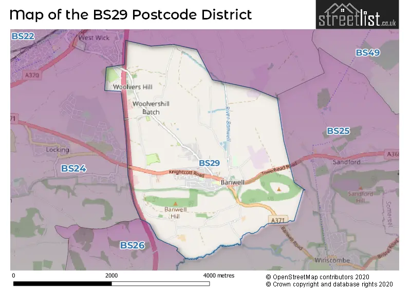
Map of the BS29 Postcode District
Explore the postcode district by using our interactive map.
Circles represent recorded crime; the larger the circle, the higher the crime rates.


Your support helps keep this site running!
If you enjoy using this website, consider buying me a coffee to help cover hosting costs.
Where is the BS29 District?
To give you an idea where the district is located we have created the following table showing nearby towns.
Nearest Towns to BS29
| Town | Distance (miles) | Direction |
|---|---|---|
| Axbridge | 4.00 | SE |
| Weston-super-Mare | 4.59 | W |
| Clevedon | 7.17 | N |
| Burnham-on-Sea | 8.46 | SW |
| Nailsea | 8.47 | NE |
| Portishead | 11.41 | NNE |
| Wells | 13.04 | SE |
| Bristol | 14.35 | NE |
| Glastonbury | 14.52 | SSE |
| Penarth | 14.86 | WNW |
| Bridgwater | 15.38 | SSW |
| Street | 15.42 | SSE |
| Keynsham | 17.14 | ENE |
| Midsomer Norton | 17.20 | E |
| Shepton Mallet | 17.25 | SE |
| Filton | 17.81 | NE |
| North Petherton | 17.91 | SSW |
| Barry | 17.99 | WNW |
| Newport | 18.38 | NNW |
| Caldicot | 18.60 | NNE |
The post town for this district is BANWELL.
Postcode Information for District BS29 (Total Geographical Postcodes: 110)
| Location | Post Town | Sector | Number of Postcodes |
|---|---|---|---|
| BANWELL | BANWELL | BS29 6 | 110 |
Retail and Shopping in BS29
| Street | Town | Locality | Number of Shops | Central Postcode | View on Google Maps |
|---|---|---|---|---|---|
| WEST STREET | BANWELL | 7 | BS29 6DA | View on Google Maps |
The primary settlement in the BS29 postcode district is Banwell, located in the county of Somerset. The most significant post town in this postcode district is also Banwell.
When it comes to local government, postal geography often disregards political borders. However, this district intersects the following councils: the district mostly encompasses the North Somerset area with a total of 123 postal codes.
The BS29 postal code covers the settlement of BANWELL.
The BS29 Postcode shares a border with BS24 (WESTON-SUPER-MARE, Locking, West Wick) and BS25 (WINSCOMBE, Sandford, Shipham).
Postcode Sectors


Dentists in the BS29 District
No dentists found in this district.
Doctors in the BS29 District
| # | Name | Address | Type | Contact |
|---|---|---|---|---|
| 1 | Dr John Dh & Partners | , WESTFIELD ROAD , BANWELL , AVON , BS29 6AD | BRANCH SURGERY |
Chemists in the BS29 District
| # | Name | Address | Type | Contact |
|---|---|---|---|---|
| 1 | Banwell Village Pharmacy | WESTFIELD ROAD , BANWELL , AVON , BS29 6AD | PHARMACY |
Opticians in the BS29 District
No Opticians found in this district.
Schools in the Sector
Banwell Primary School
Phase: Primary
Address: West Street , Banwell
Postcode: BS29 6DB
Headteacher: Mrs Claire Pocock (Headteacher)
Ofsted Rating: Good
Stations in the Sector
No stations found in this postcode district.
Accessable Motorway Junctions
M5 J21
Average Driving Time from within the district: 5.64
Average Driving Distance: 3.30
Number of Postcodes that can access the Motorway Junction: 110
M5 J20
Average Driving Time from within the district: 11.12
Average Driving Distance: 8.97
Number of Postcodes that can access the Motorway Junction: 110
M5 J22
Average Driving Time from within the district: 15.12
Average Driving Distance: 12.85
Number of Postcodes that can access the Motorway Junction: 110
M5 J18
Average Driving Time from within the district: 17.04
Average Driving Distance: 15.41
Number of Postcodes that can access the Motorway Junction: 1
M5 J19
Average Driving Time from within the district: 17.22
Average Driving Distance: 15.29
Number of Postcodes that can access the Motorway Junction: 110
M5 J23
Average Driving Time from within the district: 19.87
Average Driving Distance: 17.75
Number of Postcodes that can access the Motorway Junction: 109
Weather Forecast for Weston-Super-Mare No 2
| Time Period | Icon | Description | Temperature | Rain Probability | Wind |
|---|---|---|---|---|---|
| 12:00 to 15:00 | Overcast | 9.0°C (feels like 7.0°C) | 12.00% | SSE 7 mph | |
| 15:00 to 18:00 | Cloudy | 11.0°C (feels like 9.0°C) | 9.00% | S 9 mph | |
| 18:00 to 21:00 | Cloudy | 9.0°C (feels like 7.0°C) | 48.00% | SSE 11 mph | |
| 21:00 to 00:00 | Light rain | 9.0°C (feels like 6.0°C) | 54.00% | SSE 16 mph |
| Time Period | Icon | Description | Temperature | Rain Probability | Wind |
|---|---|---|---|---|---|
| 00:00 to 03:00 | Light rain | 10.0°C (feels like 7.0°C) | 51.00% | S 18 mph | |
| 03:00 to 06:00 | Overcast | 11.0°C (feels like 8.0°C) | 14.00% | S 16 mph | |
| 06:00 to 09:00 | Cloudy | 12.0°C (feels like 8.0°C) | 28.00% | S 18 mph | |
| 09:00 to 12:00 | Overcast | 12.0°C (feels like 9.0°C) | 18.00% | S 18 mph | |
| 12:00 to 15:00 | Cloudy | 13.0°C (feels like 10.0°C) | 16.00% | S 18 mph | |
| 15:00 to 18:00 | Light rain shower (day) | 14.0°C (feels like 11.0°C) | 32.00% | SSW 16 mph | |
| 18:00 to 21:00 | Cloudy | 12.0°C (feels like 10.0°C) | 7.00% | SSW 13 mph | |
| 21:00 to 00:00 | Cloudy | 11.0°C (feels like 8.0°C) | 6.00% | S 13 mph |
| Time Period | Icon | Description | Temperature | Rain Probability | Wind |
|---|---|---|---|---|---|
| 00:00 to 03:00 | Overcast | 11.0°C (feels like 8.0°C) | 9.00% | S 16 mph | |
| 03:00 to 06:00 | Overcast | 11.0°C (feels like 8.0°C) | 22.00% | S 18 mph | |
| 06:00 to 09:00 | Light rain shower (night) | 12.0°C (feels like 8.0°C) | 39.00% | S 20 mph | |
| 09:00 to 12:00 | Light rain | 12.0°C (feels like 8.0°C) | 41.00% | SSE 22 mph | |
| 12:00 to 15:00 | Light rain | 12.0°C (feels like 8.0°C) | 46.00% | S 25 mph | |
| 15:00 to 18:00 | Light rain shower (day) | 12.0°C (feels like 9.0°C) | 43.00% | S 20 mph | |
| 18:00 to 21:00 | Cloudy | 11.0°C (feels like 9.0°C) | 23.00% | SSW 13 mph | |
| 21:00 to 00:00 | Cloudy | 10.0°C (feels like 8.0°C) | 16.00% | SSW 9 mph |
| Time Period | Icon | Description | Temperature | Rain Probability | Wind |
|---|---|---|---|---|---|
| 00:00 to 03:00 | Cloudy | 9.0°C (feels like 7.0°C) | 12.00% | SSW 9 mph | |
| 03:00 to 06:00 | Cloudy | 8.0°C (feels like 7.0°C) | 10.00% | SSW 7 mph | |
| 06:00 to 09:00 | Cloudy | 8.0°C (feels like 6.0°C) | 9.00% | S 7 mph | |
| 09:00 to 12:00 | Cloudy | 9.0°C (feels like 7.0°C) | 7.00% | SSW 7 mph | |
| 12:00 to 15:00 | Partly cloudy (day) | 11.0°C (feels like 9.0°C) | 5.00% | WSW 7 mph | |
| 15:00 to 18:00 | Sunny day | 11.0°C (feels like 9.0°C) | 8.00% | W 9 mph | |
| 18:00 to 21:00 | Clear night | 9.0°C (feels like 7.0°C) | 2.00% | SW 7 mph | |
| 21:00 to 00:00 | Clear night | 8.0°C (feels like 6.0°C) | 1.00% | SSW 9 mph |
| Time Period | Icon | Description | Temperature | Rain Probability | Wind |
|---|---|---|---|---|---|
| 00:00 to 03:00 | Cloudy | 8.0°C (feels like 5.0°C) | 9.00% | S 11 mph | |
| 03:00 to 06:00 | Cloudy | 8.0°C (feels like 5.0°C) | 10.00% | S 13 mph | |
| 06:00 to 09:00 | Cloudy | 9.0°C (feels like 6.0°C) | 16.00% | S 18 mph | |
| 09:00 to 12:00 | Light rain | 10.0°C (feels like 7.0°C) | 56.00% | S 22 mph | |
| 12:00 to 15:00 | Light rain | 12.0°C (feels like 8.0°C) | 55.00% | SSW 25 mph | |
| 15:00 to 18:00 | Heavy rain | 12.0°C (feels like 8.0°C) | 76.00% | SSW 22 mph | |
| 18:00 to 21:00 | Cloudy | 12.0°C (feels like 8.0°C) | 26.00% | SSW 20 mph | |
| 21:00 to 00:00 | Light rain | 11.0°C (feels like 8.0°C) | 53.00% | SW 18 mph |
| Postal Sector | Delivery Office |
|---|---|
| BS29 6 | Winscombe Delivery Office |
| B | S | 2 | 9 | - | X | X | X |
| B | S | 2 | 9 | Space | Numeric | Letter | Letter |
Street List for the BS29 District
Current Monthly Rental Prices
| # Bedrooms | Min Price | Max Price | Avg Price |
|---|---|---|---|
| 2 | £900 | £900 | £900 |
Current House Prices
| # Bedrooms | Min Price | Max Price | Avg Price |
|---|---|---|---|
| 3 | £345,000 | £475,000 | £404,444 |
| 4 | £350,000 | £870,000 | £538,163 |
| 5 | £875,000 | £875,000 | £875,000 |
Estate Agents
| Logo | Name | Brand Name | Address | Contact Number |
|---|---|---|---|---|
 | Mead Fields | Bellway Homes (South West) | Wolvershill Road, Weston Super Mare, BS29 6AN | 01934 317818 |
 | Jubilee Gardens | Strongvox | Wolvershill Road, Banwell, BS29 6DJ | 01934 315047 |
 | Worle | Harris & Lee | 114 High Street, Worle, Weston-Super-Mare, BS22 6HD | 01934 315079 |
 | Weston Super Mare | Ashley Leahy Estate Agents | 306 Park Way Worle Weston-Super-Mare BS22 6WA | 01934 315041 |
 | Worle | Palmer Snell | 181 High Street, Worle, Weston-Super-Mare, Somerset, BS22 0JS | 01934 315044 |
Yearly House Price Averages for the District
| Type of Property | 2018 Average | 2018 Sales | 2017 Average | 2017 Sales | 2016 Average | 2016 Sales | 2015 Average | 2015 Sales |
|---|---|---|---|---|---|---|---|---|
| Detached | £349,550 | 14 | £322,164 | 20 | £313,757 | 22 | £334,404 | 26 |
| Semi-Detached | £240,548 | 21 | £197,759 | 17 | £206,798 | 23 | £217,937 | 15 |
| Terraced | £191,500 | 4 | £343,500 | 2 | £212,889 | 9 | £183,000 | 2 |
| Flats | £0 | 0 | £143,250 | 2 | £0 | 0 | £79,483 | 3 |