A wide range of spatial data has been analysed to present this overview of the BS2 8 Postcode sector. If you would like anything added, please contact us.
The BS2 8 postcode sector is within the county of Bristol.
Did you know? According to the 2021 Census, the BS2 8 postcode sector is home to a bustling 7,547 residents!
Given that each sector allows for 400 unique postcode combinations. Letters C, I, K, M, O and V are not allowed in the last two letters of a postcode. With 218 postcodes already in use, this leaves 182 units available.
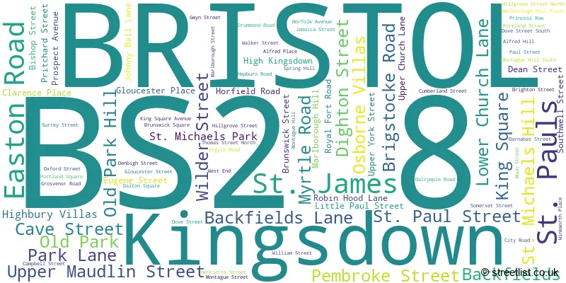
The largest settlement in the BS2 8 postal code is BRISTOL followed by Kingsdown, and St. Pauls.
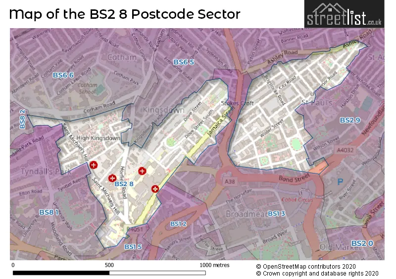
The BS2 8 Postcode shares a border with BS1 3 (BRISTOL), BS1 2 (BRISTOL), BS1 5 (BRISTOL), BS2 9 (BRISTOL, St. Pauls, St. Agnes), BS6 5 (BRISTOL, St. Andrews, Montpelier), BS6 6 (BRISTOL, Redland, Cotham), BS8 1 (BRISTOL, Clifton, Tyndalls Park) and BS8 2 (BRISTOL, Clifton).
Map of the BS2 8 Postcode Sector
Explore the BS2 8 postcode sector by using our interactive map.
The sector is within the post town of BRISTOL.
BS2 8 is a postcode sector within the BS2 postcode district which is within the BS Bristol postcode area.
The Royal Mail delivery office for the BS2 8 postal sector is the Bristol East Central Delivery Office.
The area of the BS2 8 postcode sector is 0.23 square miles which is 0.59 square kilometres or 146.76 square acres.
Your support helps keep this site running!
If you enjoy using this website, consider buying me a coffee to help cover hosting costs.

| B | S | 2 | - | 8 | X | X |
| B | S | 2 | Space | 8 | Letter | Letter |
Official List of Streets
BRISTOL (68 Streets)
(11 Streets)
Kingsdown (9 Streets)
St. Pauls (5 Streets)
St. James (1 Streets)
Unofficial Streets or Alternative Spellings
BRISTOL
ALBERT PARK ARMADA PLACE ASHLEY ROAD BELGRAVE ROAD BOND STREET BOND STREET SOUTH BURNELL DRIVE COLSTON STREET COLSTON YARD COREY CLOSE COTHAM ROAD SOUTH FRANKLYN LANE FREMANTLE ROAD FREMANTLE SQUARE KINGSDOWN PARADE LITTLE BISHOP STREET LOWER MAUDLIN STREET LUDLOW CLOSE MONTAGUE PLACE NEWFOUNDLAND CIRCUS THOMAS STREET TYNDALL AVENUE WHITSON STREET WOODLAND ROADMontpelier
BROOK ROADSt. Pauls
BISHOP STREET PRINCES STREET SAINT MATTHEWS AVENUE SAINT MATTHEWS ROAD SAINT MICHAELS HILL SAINT MICHAELS PARK SAINT NICHOLAS ROAD SAINT PAUL STREET ST NICHOLAS ROAD TYNDALLS PARK ROAD WOODLAND WALKWeather Forecast for BS2 8
Weather Forecast for Bristol
| Time Period | Icon | Description | Temperature | Rain Probability | Wind |
|---|---|---|---|---|---|
| 15:00 to 18:00 | Overcast | 9.0°C (feels like 7.0°C) | 9.00% | SSE 9 mph | |
| 18:00 to 21:00 | Overcast | 7.0°C (feels like 5.0°C) | 9.00% | SSE 9 mph | |
| 21:00 to 00:00 | Overcast | 7.0°C (feels like 4.0°C) | 9.00% | SSE 9 mph |
| Time Period | Icon | Description | Temperature | Rain Probability | Wind |
|---|---|---|---|---|---|
| 00:00 to 03:00 | Overcast | 6.0°C (feels like 3.0°C) | 9.00% | S 9 mph | |
| 03:00 to 06:00 | Overcast | 6.0°C (feels like 3.0°C) | 9.00% | SSE 9 mph | |
| 06:00 to 09:00 | Overcast | 5.0°C (feels like 3.0°C) | 8.00% | SSE 7 mph | |
| 09:00 to 12:00 | Cloudy | 5.0°C (feels like 2.0°C) | 6.00% | SSE 7 mph | |
| 12:00 to 15:00 | Cloudy | 7.0°C (feels like 5.0°C) | 4.00% | S 9 mph | |
| 15:00 to 18:00 | Partly cloudy (day) | 8.0°C (feels like 6.0°C) | 2.00% | S 7 mph | |
| 18:00 to 21:00 | Cloudy | 6.0°C (feels like 5.0°C) | 6.00% | S 4 mph | |
| 21:00 to 00:00 | Partly cloudy (night) | 6.0°C (feels like 4.0°C) | 3.00% | SSE 7 mph |
| Time Period | Icon | Description | Temperature | Rain Probability | Wind |
|---|---|---|---|---|---|
| 00:00 to 03:00 | Overcast | 6.0°C (feels like 4.0°C) | 9.00% | S 4 mph | |
| 03:00 to 06:00 | Overcast | 6.0°C (feels like 4.0°C) | 9.00% | S 7 mph | |
| 06:00 to 09:00 | Overcast | 6.0°C (feels like 3.0°C) | 9.00% | S 7 mph | |
| 09:00 to 12:00 | Overcast | 6.0°C (feels like 4.0°C) | 8.00% | S 7 mph | |
| 12:00 to 15:00 | Cloudy | 9.0°C (feels like 7.0°C) | 5.00% | S 9 mph | |
| 15:00 to 18:00 | Cloudy | 10.0°C (feels like 8.0°C) | 6.00% | SSW 11 mph | |
| 18:00 to 21:00 | Partly cloudy (night) | 8.0°C (feels like 6.0°C) | 2.00% | S 9 mph | |
| 21:00 to 00:00 | Cloudy | 8.0°C (feels like 5.0°C) | 5.00% | S 11 mph |
| Time Period | Icon | Description | Temperature | Rain Probability | Wind |
|---|---|---|---|---|---|
| 00:00 to 03:00 | Cloudy | 8.0°C (feels like 5.0°C) | 5.00% | S 11 mph | |
| 03:00 to 06:00 | Cloudy | 8.0°C (feels like 5.0°C) | 5.00% | S 11 mph | |
| 06:00 to 09:00 | Cloudy | 8.0°C (feels like 5.0°C) | 7.00% | S 11 mph | |
| 09:00 to 12:00 | Cloudy | 9.0°C (feels like 6.0°C) | 11.00% | S 13 mph | |
| 12:00 to 15:00 | Light rain | 11.0°C (feels like 8.0°C) | 53.00% | SSW 16 mph | |
| 15:00 to 18:00 | Heavy rain | 11.0°C (feels like 8.0°C) | 81.00% | SW 13 mph | |
| 18:00 to 21:00 | Light rain shower (night) | 9.0°C (feels like 7.0°C) | 39.00% | WSW 11 mph | |
| 21:00 to 00:00 | Clear night | 8.0°C (feels like 5.0°C) | 8.00% | WSW 9 mph |
| Time Period | Icon | Description | Temperature | Rain Probability | Wind |
|---|---|---|---|---|---|
| 00:00 to 03:00 | Clear night | 6.0°C (feels like 4.0°C) | 3.00% | W 7 mph | |
| 03:00 to 06:00 | Clear night | 5.0°C (feels like 3.0°C) | 2.00% | W 4 mph | |
| 06:00 to 09:00 | Clear night | 3.0°C (feels like 2.0°C) | 1.00% | W 4 mph | |
| 09:00 to 12:00 | Cloudy | 4.0°C (feels like 3.0°C) | 5.00% | NW 4 mph | |
| 12:00 to 15:00 | Cloudy | 8.0°C (feels like 6.0°C) | 4.00% | NW 4 mph | |
| 15:00 to 18:00 | Cloudy | 8.0°C (feels like 7.0°C) | 4.00% | N 4 mph | |
| 18:00 to 21:00 | Cloudy | 6.0°C (feels like 4.0°C) | 5.00% | NNW 4 mph | |
| 21:00 to 00:00 | Partly cloudy (night) | 4.0°C (feels like 3.0°C) | 2.00% | E 4 mph |
House Prices in the BS2 8 Postcode Sector
| Type of Property | 2018 Average | 2018 Sales | 2017 Average | 2017 Sales | 2016 Average | 2016 Sales | 2015 Average | 2015 Sales |
|---|---|---|---|---|---|---|---|---|
| Detached | £0 | 0 | £417,500 | 1 | £433,333 | 3 | £425,000 | 1 |
| Semi-Detached | £785,000 | 2 | £410,500 | 2 | £365,000 | 1 | £298,000 | 2 |
| Terraced | £555,267 | 12 | £421,698 | 13 | £464,735 | 20 | £402,071 | 21 |
| Flats | £218,313 | 146 | £243,235 | 173 | £229,719 | 116 | £205,296 | 105 |
Important Postcodes BS2 8 in the Postcode Sector
BS2 8AA is the postcode for Royal Mail, Bristol East Central Delivery Office Unit, 16 City Business Park, Easton Road
BS2 8AE is the postcode for Education Centre, Upper Maudlin Street
BS2 8BE is the postcode for Willow Park C of E Primary School, Park Lane, Willow Park C of E Primary School Annex, Park Lane, and MAIN BUILDING, St. Michael on the Mount C of E Primary School, Park Lane
BS2 8BJ is the postcode for United Bristol Healthcare NHS Trust, Bristol Royal Hospital For Children, and Bristol Royal Hospital for Sick Children, Upper Maudlin Street
BS2 8DT is the postcode for King David Residence, St. Michaels Hill, and King David Residence, Upper Maudlin Street, City Centre
BS2 8ED is the postcode for Bristol Haematology & Oncology Centre, Horfield Road, and United Bristol Healthcare NHS Trust, Bristol Haematology & Oncology Centre
BS2 8EE is the postcode for Avon Health Authority, 26-27 King Square, and Bristol PCT, Bristol PCT HQ, King Square House
BS2 8EG is the postcode for United Bristol Healthcare NHS Trust, St Michaels Hospital, and St. Michaels Hospital, Southwell Street
BS2 8EL is the postcode for Public Health Laboratory Bristol, Specialist Microbiology Network
BS2 8HL is the postcode for Kingsdown Sports Centre, Portland Street, and Kingsdown Sports Centre, Portland Street, Kingsdown
BS2 8HR is the postcode for Colston Fort Flats, Henrietta Street
BS2 8HW is the postcode for KINGSDOWN BUILDING, Bristol Royal Infirmary, Marlborough Street, TERRELL STREET BLOCK, Bristol Royal Infirmary, Marlborough Street, QUEEN'S BUILDING, KING EDWARD BUILDING AND OLD BUILDING, Bristol Royal Infirmary, Marlborough Street, United Bristol Healthcare NHS Trust, Bristol Royal Infirmary, BRISTOL DERMATOLOGY CENTRE, Bristol Royal Infirmary, Marlborough Street, THE BRISTOL HEART INSTITUTE, Bristol Royal Infirmary, Marlborough Street, and TERREL STREET BLOCK, Bristol Royal Infirmary, Marlborough Street
BS2 8PH is the postcode for Wilder House, Wilder Street
BS2 8QH is the postcode for 9 Wilder Street, York Court
BS2 8QN is the postcode for Probation Office, Decourcy House, Upper York Street
BS2 8UB is the postcode for BRIGSTOCKE HOSTEL, 4-12, Brigstocke Road
BS2 8UH is the postcode for The Settlement, 74-80 City Road
BS2 8XJ is the postcode for St. Pauls Learning & Family Centre, 94 Grosvenor Road
| The BS2 8 Sector is within these Local Authorities |
|
|---|---|
| The BS2 8 Sector is within these Counties |
|
| The BS2 8 Sector is within these Water Company Areas |
|