A wide range of spatial data has been analysed to present this overview of the BS10 7 Postcode sector. If you would like anything added, please contact us.
The BS10 7 postcode sector stands on the Bristol and Gloucestershire border.
Did you know? According to the 2021 Census, the BS10 7 postcode sector is home to a bustling 9,194 residents!
Given that each sector allows for 400 unique postcode combinations. Letters C, I, K, M, O and V are not allowed in the last two letters of a postcode. With 263 postcodes already in use, this leaves 137 units available.
The largest settlement in the BS10 7 postal code is BRISTOL followed by Henbury, and Hallen.
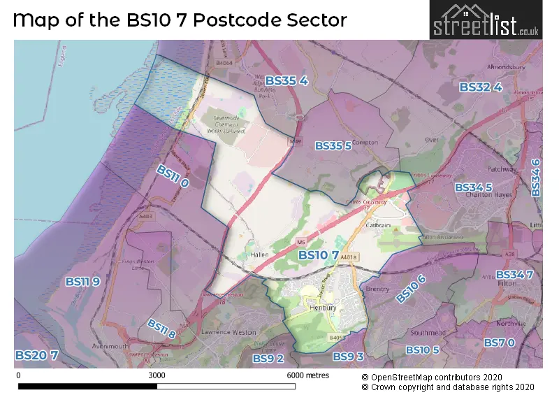
The BS10 7 Postcode shares a border with BS9 2 (BRISTOL, Coombe Dingle, Sea Mills), BS32 4 (Almondsbury, Bradley Stoke, Tockington), BS35 4 (Severn Beach, Pilning, Olveston), BS35 5 (Easter Compton), BS9 3 (BRISTOL, Westbury-on-Trym), BS10 6 (BRISTOL, Brentry, Westbury-on-Trym), BS11 0 (BRISTOL, Shirehampton, Chittening) and BS34 5 (Patchway).
Map of the BS10 7 Postcode Sector
Explore the BS10 7 postcode sector by using our interactive map.
The sector is within the post town of BRISTOL.
BS10 7 is a postcode sector within the BS10 postcode district which is within the BS Bristol postcode area.
The Royal Mail delivery office for the BS10 7 postal sector is the Westbury On Trym Delivery Office.
The area of the BS10 7 postcode sector is 5.71 square miles which is 14.78 square kilometres or 3,651.62 square acres.
The BS10 7 postcode sector is crossed by the M49 motorway.
The BS10 7 postcode sector is crossed by the M5 motorway.
Waterways within the BS10 7 postcode sector include the Hazel Brook.
Your support helps keep this site running!
If you enjoy using this website, consider buying me a coffee to help cover hosting costs.

| B | S | 1 | 0 | - | 7 | X | X |
| B | S | 1 | 0 | Space | 7 | Letter | Letter |
Official List of Streets
(28 Streets)
Hallen (11 Streets)
BRISTOL (115 Streets)
Henbury (12 Streets)
Westbury-on-Trym (3 Streets)
Unofficial Streets or Alternative Spellings
BRISTOL
ARDENTON WALK BRENTRY LANE CHARLTON LANE KNOLE LANE LAWRENCE WESTON ROAD LOWER KNOLE LANE THE LAURELS YEW TREE PLACEPatchway
HIGHWOOD LANE LYSANDER ROAD ACORNS NURSERIES DRAGONSWELL ROAD HI-WAYS PARK MAIN DRIVE MINORS LANE ROAD THREE SHEEPWOOD GARDENS SILVEYS COTTAGES WASHINGPOOL LANEHallen
ISON HILLEaster Compton
BERWICK LANE BLACKHORSE HILL HOLLYWOOD LANESevern Beach
PALMER AVENUEChittening
SEVERN ROADWeather Forecast for BS10 7
Weather Forecast for Henbury
| Time Period | Icon | Description | Temperature | Rain Probability | Wind |
|---|---|---|---|---|---|
| 06:00 to 09:00 | Cloudy | 4.0°C (feels like 3.0°C) | 5.00% | SE 4 mph | |
| 09:00 to 12:00 | Cloudy | 4.0°C (feels like 2.0°C) | 5.00% | SE 7 mph | |
| 12:00 to 15:00 | Cloudy | 7.0°C (feels like 5.0°C) | 4.00% | S 7 mph | |
| 15:00 to 18:00 | Overcast | 8.0°C (feels like 5.0°C) | 7.00% | S 9 mph | |
| 18:00 to 21:00 | Overcast | 6.0°C (feels like 3.0°C) | 7.00% | SSE 9 mph | |
| 21:00 to 00:00 | Cloudy | 5.0°C (feels like 2.0°C) | 7.00% | SSE 9 mph |
| Time Period | Icon | Description | Temperature | Rain Probability | Wind |
|---|---|---|---|---|---|
| 00:00 to 03:00 | Cloudy | 5.0°C (feels like 2.0°C) | 6.00% | SSE 9 mph | |
| 03:00 to 06:00 | Cloudy | 5.0°C (feels like 2.0°C) | 6.00% | SSE 9 mph | |
| 06:00 to 09:00 | Cloudy | 4.0°C (feels like 1.0°C) | 7.00% | SSE 9 mph | |
| 09:00 to 12:00 | Cloudy | 4.0°C (feels like 2.0°C) | 9.00% | SE 7 mph | |
| 12:00 to 15:00 | Cloudy | 7.0°C (feels like 4.0°C) | 7.00% | S 9 mph | |
| 15:00 to 18:00 | Cloudy | 8.0°C (feels like 5.0°C) | 7.00% | S 7 mph | |
| 18:00 to 21:00 | Cloudy | 6.0°C (feels like 4.0°C) | 5.00% | S 7 mph | |
| 21:00 to 00:00 | Partly cloudy (night) | 5.0°C (feels like 3.0°C) | 2.00% | S 7 mph |
| Time Period | Icon | Description | Temperature | Rain Probability | Wind |
|---|---|---|---|---|---|
| 00:00 to 03:00 | Cloudy | 5.0°C (feels like 2.0°C) | 5.00% | S 7 mph | |
| 03:00 to 06:00 | Overcast | 5.0°C (feels like 2.0°C) | 8.00% | S 7 mph | |
| 06:00 to 09:00 | Cloudy | 5.0°C (feels like 2.0°C) | 6.00% | S 7 mph | |
| 09:00 to 12:00 | Cloudy | 6.0°C (feels like 3.0°C) | 6.00% | S 7 mph | |
| 12:00 to 15:00 | Cloudy | 8.0°C (feels like 6.0°C) | 5.00% | SSW 11 mph | |
| 15:00 to 18:00 | Cloudy | 9.0°C (feels like 7.0°C) | 5.00% | SSW 11 mph | |
| 18:00 to 21:00 | Cloudy | 8.0°C (feels like 5.0°C) | 5.00% | S 11 mph | |
| 21:00 to 00:00 | Partly cloudy (night) | 7.0°C (feels like 4.0°C) | 6.00% | S 11 mph |
| Time Period | Icon | Description | Temperature | Rain Probability | Wind |
|---|---|---|---|---|---|
| 00:00 to 03:00 | Cloudy | 7.0°C (feels like 4.0°C) | 11.00% | S 11 mph | |
| 03:00 to 06:00 | Partly cloudy (night) | 8.0°C (feels like 5.0°C) | 12.00% | S 13 mph | |
| 06:00 to 09:00 | Cloudy | 8.0°C (feels like 5.0°C) | 20.00% | S 13 mph | |
| 09:00 to 12:00 | Cloudy | 8.0°C (feels like 5.0°C) | 24.00% | SSW 13 mph | |
| 12:00 to 15:00 | Light rain | 10.0°C (feels like 7.0°C) | 54.00% | SSW 13 mph | |
| 15:00 to 18:00 | Heavy rain | 10.0°C (feels like 7.0°C) | 73.00% | SW 13 mph | |
| 18:00 to 21:00 | Light rain | 8.0°C (feels like 6.0°C) | 48.00% | WSW 9 mph | |
| 21:00 to 00:00 | Clear night | 7.0°C (feels like 5.0°C) | 10.00% | WSW 9 mph |
Schools and Places of Education Within the BS10 7 Postcode Sector
Blaise High School
Academy sponsor led
Station Road, Bristol, Bristol, BS10 7QH
Head: Mr Nat Nabarro
Ofsted Rating: Good
Inspection: 2023-09-28 (492 days ago)
Website: Visit Blaise High School Website
Phone: 01179030100
Number of Pupils: 904
Blaise Primary and Nursery School
Community school
Clavell Road, Bristol, Bristol, BS10 7EJ
Head: Mr Massimo Bonaddio
Ofsted Rating: Outstanding
Inspection: 2013-11-14 (4097 days ago)
Website: Visit Blaise Primary and Nursery School Website
Phone: 01173772424
Number of Pupils: 436
Henbury Court Primary Academy
Academy sponsor led
Trevelyan Walk, Bristol, , BS10 7NY
Head: Mr Jake Howarth-Brown
Ofsted Rating: Good
Inspection: 2019-03-27 (2138 days ago)
Website: Visit Henbury Court Primary Academy Website
Phone: 01173772196
Number of Pupils: 302
North Star 82�
Academy special converter
Rectory Gardens, Bristol, Avon, BS10 7AH
Head: Mr James Wookey
Ofsted Rating: Good
Inspection: 2023-09-20 (500 days ago)
Website: Visit North Star 82� Website
Phone: 01173772175
Number of Pupils: 60
House Prices in the BS10 7 Postcode Sector
| Type of Property | 2018 Average | 2018 Sales | 2017 Average | 2017 Sales | 2016 Average | 2016 Sales | 2015 Average | 2015 Sales |
|---|---|---|---|---|---|---|---|---|
| Detached | £338,876 | 17 | £394,000 | 21 | £406,632 | 19 | £336,235 | 17 |
| Semi-Detached | £291,498 | 28 | £247,554 | 26 | £246,396 | 36 | £217,750 | 20 |
| Terraced | £237,112 | 40 | £217,881 | 47 | £229,083 | 29 | £198,969 | 57 |
| Flats | £162,309 | 29 | £154,780 | 32 | £144,984 | 37 | £136,253 | 47 |
Important Postcodes BS10 7 in the Postcode Sector
BS10 7AH is the postcode for Woodstock School, Rectory Gardens, and North Star 82-�, Rectory Gardens
BS10 7DP is the postcode for John Milton Health Clinic, Crow Lane
BS10 7DR is the postcode for Bristol City Council, Henbury Library, 179 Crow Lane
BS10 7EH is the postcode for The Bristol Rehab Centre, 20 Ellsworth Road
BS10 7EJ is the postcode for Blaise Primary School & Nursery, Clavell Road
BS10 7HG is the postcode for St. Matthias North, Machin Road, and St. Matthias Academy (North), Machin Road
BS10 7NG is the postcode for Henbury Leisure Centre, Avonmouth Way, and Henbury Leisure Centre, Avonmouth Way, Henbury
BS10 7NY is the postcode for Henbury Court Primary School, Trevelyan Walk, NEW CLASSROOM BLOCK, Henbury Court Primary School, Trevelyan Walk, BUILDING A, Henbury Court Primary School, Trevelyan Walk, and BUILDING B, Henbury Court Primary School, Trevelyan Walk
BS10 7QH is the postcode for Henbury Secondary School, Station Road, Blaise High School, Station Road, H B G F M Construction, Station Road, and Blaise High School, Station Road, Henbury
BS10 7QS is the postcode for Blaise Castle House Museum, Henbury Road, Henbury, and Blaise Castle House Museum, Henbury Road
| The BS10 7 Sector is within these Local Authorities |
|
|---|---|
| The BS10 7 Sector is within these Counties |
|
| The BS10 7 Sector is within these Water Company Areas |
|
Tourist Attractions within the BS10 7 Postcode Area
We found 1 visitor attractions within the BS10 postcode area
| Wild Place Project |
|---|
| Wildlife |
| Safari Park / Zoo / Aquarium / Aviary |
| View Wild Place Project on Google Maps |