A wide range of spatial data has been analysed to present this overview of the BS10 6 Postcode sector. If you would like anything added, please contact us.
The BS10 6 postcode sector stands on the Bristol and Gloucestershire border.
Did you know? According to the 2021 Census, the BS10 6 postcode sector is home to a bustling 11,355 residents!
Given that each sector allows for 400 unique postcode combinations. Letters C, I, K, M, O and V are not allowed in the last two letters of a postcode. With 256 postcodes already in use, this leaves 144 units available.
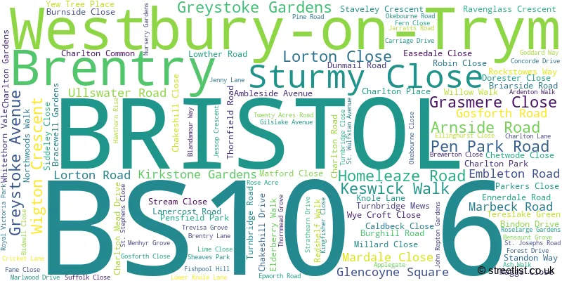
The largest settlement in the BS10 6 postal code is BRISTOL followed by Brentry, and Westbury-on-Trym.
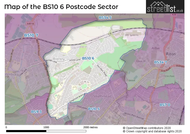
The BS10 6 Postcode shares a border with BS34 7 (Filton, BRISTOL), BS9 3 (BRISTOL, Westbury-on-Trym), BS10 5 (BRISTOL, Westbury-on-Trym, Southmead), BS10 7 (BRISTOL, Henbury, Hallen) and BS34 5 (Patchway).
Map of the BS10 6 Postcode Sector
Explore the BS10 6 postcode sector by using our interactive map.
The sector is within the post town of BRISTOL.
BS10 6 is a postcode sector within the BS10 postcode district which is within the BS Bristol postcode area.
The Royal Mail delivery office for the BS10 6 postal sector is the Westbury On Trym Delivery Office.
The area of the BS10 6 postcode sector is 1.38 square miles which is 3.56 square kilometres or 880.51 square acres.
Your support helps keep this site running!
If you enjoy using this website, consider buying me a coffee to help cover hosting costs.

| B | S | 1 | 0 | - | 6 | X | X |
| B | S | 1 | 0 | Space | 6 | Letter | Letter |
Official List of Streets
BRISTOL (98 Streets)
Brentry (10 Streets)
Westbury-on-Trym (5 Streets)
Southmead (4 Streets)
Unofficial Streets or Alternative Spellings
BRISTOL
DAVIDSON ROAD DONCASTER ROAD NORTHOVER ROAD SWANMOOR CRESCENT TRANMERE AVENUE TROWBRIDGE ROAD WESTACRE CLOSEFilton
GOLF COURSE LANE WEST WAY BADGERS DRIVE BURNESIDE CLOSE PAYNES ORCHARD PARK SAINT JOSEPHS ROAD SAINT STEPHENS CLOSE SAINT WULFSTANS AVENUEWestbury-on-Trym
EASTLEIGH ROAD PASSAGE ROAD THE RIDGEWAYWeather Forecast for BS10 6
Weather Forecast for Filton
| Time Period | Icon | Description | Temperature | Rain Probability | Wind |
|---|---|---|---|---|---|
| 18:00 to 21:00 | Overcast | 7.0°C (feels like 4.0°C) | 9.00% | SSE 9 mph | |
| 21:00 to 00:00 | Overcast | 6.0°C (feels like 3.0°C) | 9.00% | SSE 11 mph |
| Time Period | Icon | Description | Temperature | Rain Probability | Wind |
|---|---|---|---|---|---|
| 00:00 to 03:00 | Overcast | 5.0°C (feels like 2.0°C) | 9.00% | S 9 mph | |
| 03:00 to 06:00 | Overcast | 5.0°C (feels like 2.0°C) | 9.00% | SSE 9 mph | |
| 06:00 to 09:00 | Overcast | 5.0°C (feels like 2.0°C) | 8.00% | SSE 9 mph | |
| 09:00 to 12:00 | Cloudy | 4.0°C (feels like 1.0°C) | 7.00% | SSE 9 mph | |
| 12:00 to 15:00 | Cloudy | 7.0°C (feels like 4.0°C) | 5.00% | S 9 mph | |
| 15:00 to 18:00 | Partly cloudy (day) | 7.0°C (feels like 5.0°C) | 3.00% | S 7 mph | |
| 18:00 to 21:00 | Cloudy | 6.0°C (feels like 4.0°C) | 6.00% | S 7 mph | |
| 21:00 to 00:00 | Partly cloudy (night) | 5.0°C (feels like 2.0°C) | 3.00% | S 7 mph |
| Time Period | Icon | Description | Temperature | Rain Probability | Wind |
|---|---|---|---|---|---|
| 00:00 to 03:00 | Overcast | 5.0°C (feels like 3.0°C) | 9.00% | S 7 mph | |
| 03:00 to 06:00 | Overcast | 5.0°C (feels like 3.0°C) | 9.00% | S 7 mph | |
| 06:00 to 09:00 | Overcast | 5.0°C (feels like 2.0°C) | 9.00% | S 7 mph | |
| 09:00 to 12:00 | Overcast | 5.0°C (feels like 3.0°C) | 8.00% | S 7 mph | |
| 12:00 to 15:00 | Cloudy | 8.0°C (feels like 6.0°C) | 5.00% | S 9 mph | |
| 15:00 to 18:00 | Cloudy | 9.0°C (feels like 7.0°C) | 6.00% | SSW 11 mph | |
| 18:00 to 21:00 | Cloudy | 7.0°C (feels like 5.0°C) | 5.00% | S 11 mph | |
| 21:00 to 00:00 | Cloudy | 7.0°C (feels like 4.0°C) | 5.00% | S 11 mph |
| Time Period | Icon | Description | Temperature | Rain Probability | Wind |
|---|---|---|---|---|---|
| 00:00 to 03:00 | Cloudy | 7.0°C (feels like 4.0°C) | 5.00% | S 11 mph | |
| 03:00 to 06:00 | Cloudy | 7.0°C (feels like 4.0°C) | 5.00% | S 11 mph | |
| 06:00 to 09:00 | Cloudy | 7.0°C (feels like 4.0°C) | 7.00% | S 11 mph | |
| 09:00 to 12:00 | Cloudy | 8.0°C (feels like 5.0°C) | 11.00% | S 13 mph | |
| 12:00 to 15:00 | Light rain | 10.0°C (feels like 7.0°C) | 53.00% | SSW 16 mph | |
| 15:00 to 18:00 | Heavy rain | 10.0°C (feels like 7.0°C) | 81.00% | SW 13 mph | |
| 18:00 to 21:00 | Light rain shower (night) | 8.0°C (feels like 6.0°C) | 39.00% | WSW 11 mph | |
| 21:00 to 00:00 | Clear night | 7.0°C (feels like 4.0°C) | 8.00% | WSW 9 mph |
| Time Period | Icon | Description | Temperature | Rain Probability | Wind |
|---|---|---|---|---|---|
| 00:00 to 03:00 | Clear night | 6.0°C (feels like 3.0°C) | 3.00% | W 9 mph | |
| 03:00 to 06:00 | Clear night | 4.0°C (feels like 2.0°C) | 2.00% | W 7 mph | |
| 06:00 to 09:00 | Clear night | 3.0°C (feels like 1.0°C) | 1.00% | WNW 4 mph | |
| 09:00 to 12:00 | Cloudy | 3.0°C (feels like 2.0°C) | 5.00% | NW 4 mph | |
| 12:00 to 15:00 | Cloudy | 7.0°C (feels like 5.0°C) | 4.00% | NW 4 mph | |
| 15:00 to 18:00 | Cloudy | 8.0°C (feels like 6.0°C) | 4.00% | NNW 4 mph | |
| 18:00 to 21:00 | Cloudy | 5.0°C (feels like 3.0°C) | 5.00% | N 4 mph | |
| 21:00 to 00:00 | Partly cloudy (night) | 3.0°C (feels like 2.0°C) | 2.00% | E 4 mph |
Schools and Places of Education Within the BS10 6 Postcode Sector
Brentry Primary School
Community school
Brentry Lane, Bristol, , BS10 6RG
Head: Mr Geraint Clarke
Ofsted Rating: Good
Inspection: 2021-09-23 (1227 days ago)
Website: Visit Brentry Primary School Website
Phone: 01173532261
Number of Pupils: 208
Bristol Free School
Free schools
Concorde Drive, Bristol, Bristol, BS10 6NJ
Head: Susan King
Ofsted Rating: Good
Inspection: 2022-03-09 (1060 days ago)
Website: Visit Bristol Free School Website
Phone: 01179597200
Number of Pupils: 1217
Little Mead Primary Academy
Academy converter
Gosforth Road, Bristol, Bristol, BS10 6DS
Head: Co Headteacher Jenna Cooke Komilla Datta
Ofsted Rating: Requires improvement
Inspection: 2023-06-07 (605 days ago)
Website: Visit Little Mead Primary Academy Website
Phone: 01173773279
Number of Pupils: 453
House Prices in the BS10 6 Postcode Sector
| Type of Property | 2018 Average | 2018 Sales | 2017 Average | 2017 Sales | 2016 Average | 2016 Sales | 2015 Average | 2015 Sales |
|---|---|---|---|---|---|---|---|---|
| Detached | £377,083 | 12 | £369,500 | 14 | £320,773 | 11 | £302,069 | 21 |
| Semi-Detached | £244,342 | 71 | £261,850 | 70 | £254,754 | 55 | £220,348 | 80 |
| Terraced | £238,094 | 74 | £233,465 | 41 | £237,334 | 67 | £186,987 | 60 |
| Flats | £227,383 | 39 | £204,372 | 39 | £195,854 | 47 | £159,820 | 28 |
Important Postcodes BS10 6 in the Postcode Sector
BS10 6AS is the postcode for Southmead Library, Greystoke Avenue
BS10 6AY is the postcode for Elmfield House Education Welfare Office Block A, Bristol City Council, Elmfield School for Deaf Children, Greystoke Avenue, and Bristol City Council, Elmfield House, Greystoke Avenue
BS10 6BA is the postcode for Southmead House - Library, 256 Greystoke Ave, Southmead
BS10 6BQ is the postcode for Bristol City Council, 256 Greystoke Avenue
BS10 6DF is the postcode for Bristol PCT, Southmead Health Centre, and Southmead Health Centre, Ullswater Road
BS10 6DS is the postcode for Little Mead Primary Academy, Embleton Road
BS10 6EZ is the postcode for Bristol Free School, Block B, Burghill Road, Bristol Free School, Block C, Burghill Road, Bristol Free School, Block A, Burghill Road, and Bristol Free School, Burghill Road
BS10 6HZ is the postcode for Bristol Community Link North, Lanercost Road
BS10 6NB is the postcode for Woodland View, Thornfield Road, and Wellbridge House, Thornfield Road, Brentry
BS10 6NJ is the postcode for BLOCK 2, Environment Agency, Government Buildings, BLOCK 1, Environment Agency, Government Buildings, and Natural England, Block 3 Government Buildings, Burghill Road
BS10 6RG is the postcode for Brenty Primary School, Brentry Lane, and Brentry Primary School, Brentry Lane
BS10 6SP is the postcode for Bradgate Surgery, Ardenton Walk
| The BS10 6 Sector is within these Local Authorities |
|
|---|---|
| The BS10 6 Sector is within these Counties |
|
| The BS10 6 Sector is within these Water Company Areas |
|