A wide range of spatial data has been analysed to present this overview of the BN14 7 Postcode sector. If you would like anything added, please contact us.
The BN14 7 postcode sector is within the county of West Sussex.
Did you know? According to the 2021 Census, the BN14 7 postcode sector is home to a bustling 10,962 residents!
Given that each sector allows for 400 unique postcode combinations. Letters C, I, K, M, O and V are not allowed in the last two letters of a postcode. With 225 postcodes already in use, this leaves 175 units available.
The largest settlements in the BN14 7 postal code are WORTHING and Tarring.
The BN14 7 Postcode shares a border with BN11 1 (WORTHING), BN14 8 (WORTHING), BN14 9 (WORTHING), BN11 4 (WORTHING) and BN13 1 (WORTHING).
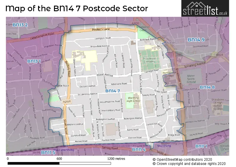
Map of the BN14 7 Postcode Sector
Explore the BN14 7 postcode sector by using our interactive map.
The sector is within the post town of WORTHING.
BN14 7 is a postcode sector within the BN14 postcode district which is within the BN Brighton postcode area.
The Royal Mail delivery office for the BN14 7 postal sector is the Worthing Delivery Office.
The area of the BN14 7 postcode sector is 0.70 square miles which is 1.82 square kilometres or 450.91 square acres.
Your support helps keep this site running!
If you enjoy using this website, consider buying me a coffee to help cover hosting costs.


| B | N | 1 | 4 | - | 7 | X | X |
| B | N | 1 | 4 | Space | 7 | Letter | Letter |
Official List of Streets
WORTHING (77 Streets)
(5 Streets)
Unofficial Streets or Alternative Spellings
WORTHING
BROADWATER ROAD BROADWATER STREET WEST CANTERBURY ROAD CECILIAN AVENUE CROSS STREET GORSE AVENUE HIGHDOWN AVENUE IVY ARCH ROAD OFFINGTON DRIVE OFFINGTON GARDENS ORME ROAD PARKFIELD ROAD SHIRLEY DRIVE TEVILLE ROAD BEECH GARDENS FAIRFIELDS HENTY CLOSE PAVILLION ROAD ST DUNSTANS ROAD THE PADDOCK CLOSE WALNUT LODGEFerring
LITTLEHAMPTON ROADWeather Forecast for BN14 7
Weather Forecast for Worthing
| Time Period | Icon | Description | Temperature | Rain Probability | Wind |
|---|---|---|---|---|---|
| 06:00 to 09:00 | Overcast | 9.0°C (feels like 6.0°C) | 14.00% | SW 16 mph | |
| 09:00 to 12:00 | Overcast | 9.0°C (feels like 6.0°C) | 10.00% | SW 18 mph | |
| 12:00 to 15:00 | Overcast | 10.0°C (feels like 6.0°C) | 9.00% | SW 22 mph | |
| 15:00 to 18:00 | Overcast | 10.0°C (feels like 6.0°C) | 10.00% | SW 22 mph | |
| 18:00 to 21:00 | Overcast | 11.0°C (feels like 7.0°C) | 12.00% | SW 25 mph | |
| 21:00 to 00:00 | Overcast | 11.0°C (feels like 7.0°C) | 12.00% | SW 25 mph |
| Time Period | Icon | Description | Temperature | Rain Probability | Wind |
|---|---|---|---|---|---|
| 00:00 to 03:00 | Overcast | 11.0°C (feels like 7.0°C) | 19.00% | SW 25 mph | |
| 03:00 to 06:00 | Light rain | 11.0°C (feels like 7.0°C) | 52.00% | SW 25 mph | |
| 06:00 to 09:00 | Overcast | 11.0°C (feels like 7.0°C) | 27.00% | SW 22 mph | |
| 09:00 to 12:00 | Overcast | 11.0°C (feels like 7.0°C) | 24.00% | SW 25 mph | |
| 12:00 to 15:00 | Light rain | 11.0°C (feels like 7.0°C) | 56.00% | SW 27 mph | |
| 15:00 to 18:00 | Heavy rain | 11.0°C (feels like 6.0°C) | 85.00% | SW 31 mph | |
| 18:00 to 21:00 | Heavy rain | 10.0°C (feels like 6.0°C) | 90.00% | WSW 27 mph | |
| 21:00 to 00:00 | Heavy rain | 8.0°C (feels like 4.0°C) | 79.00% | W 22 mph |
| Time Period | Icon | Description | Temperature | Rain Probability | Wind |
|---|---|---|---|---|---|
| 00:00 to 03:00 | Overcast | 6.0°C (feels like 2.0°C) | 24.00% | NW 16 mph | |
| 03:00 to 06:00 | Cloudy | 4.0°C (feels like 1.0°C) | 15.00% | NNW 11 mph | |
| 06:00 to 09:00 | Cloudy | 3.0°C (feels like 0.0°C) | 7.00% | NNW 9 mph | |
| 09:00 to 12:00 | Cloudy | 3.0°C (feels like -1.0°C) | 5.00% | N 9 mph | |
| 12:00 to 15:00 | Partly cloudy (day) | 4.0°C (feels like 1.0°C) | 1.00% | N 9 mph | |
| 15:00 to 18:00 | Partly cloudy (day) | 4.0°C (feels like 1.0°C) | 1.00% | N 9 mph | |
| 18:00 to 21:00 | Partly cloudy (night) | 2.0°C (feels like -2.0°C) | 2.00% | N 9 mph | |
| 21:00 to 00:00 | Partly cloudy (night) | 1.0°C (feels like -3.0°C) | 1.00% | N 9 mph |
| Time Period | Icon | Description | Temperature | Rain Probability | Wind |
|---|---|---|---|---|---|
| 00:00 to 03:00 | Clear night | 0.0°C (feels like -4.0°C) | 1.00% | N 7 mph | |
| 03:00 to 06:00 | Clear night | -1.0°C (feels like -4.0°C) | 1.00% | N 7 mph | |
| 06:00 to 09:00 | Clear night | -1.0°C (feels like -5.0°C) | 1.00% | N 7 mph | |
| 09:00 to 12:00 | Sunny day | -1.0°C (feels like -5.0°C) | 2.00% | NNW 7 mph | |
| 12:00 to 15:00 | Sunny day | 3.0°C (feels like -1.0°C) | 1.00% | NNW 7 mph | |
| 15:00 to 18:00 | Sunny day | 3.0°C (feels like 0.0°C) | 2.00% | NNW 7 mph | |
| 18:00 to 21:00 | Clear night | 0.0°C (feels like -3.0°C) | 1.00% | NW 7 mph | |
| 21:00 to 00:00 | Clear night | 0.0°C (feels like -4.0°C) | 1.00% | NW 7 mph |
Schools and Places of Education Within the BN14 7 Postcode Sector
Broadwater CofE Primary School
Voluntary aided school
Rectory Gardens, Worthing, West Sussex, BN14 7TQ
Head: Mr Aaron Morrissey
Ofsted Rating: Good
Inspection: 2023-11-29 (398 days ago)
Website: Visit Broadwater CofE Primary School Website
Phone: 01903235389
Number of Pupils: 430
Thomas A Becket Junior School
Community school
Glebeside Avenue, Worthing, West Sussex, BN14 7PR
Head: Mrs Becky Linford
Ofsted Rating: Good
Inspection: 2018-12-05 (2218 days ago)
Website: Visit Thomas A Becket Junior School Website
Phone: 01903202268
Number of Pupils: 716
Worthing High School
Academy converter
South Farm Road, Worthing, West Sussex, BN14 7AR
Head: Mr Pan Panayiotou
Ofsted Rating: Good
Inspection: 2020-03-11 (1756 days ago)
Website: Visit Worthing High School Website
Phone: 01903237864
Number of Pupils: 1075
House Prices in the BN14 7 Postcode Sector
| Type of Property | 2018 Average | 2018 Sales | 2017 Average | 2017 Sales | 2016 Average | 2016 Sales | 2015 Average | 2015 Sales |
|---|---|---|---|---|---|---|---|---|
| Detached | £459,167 | 33 | £486,707 | 29 | £417,987 | 23 | £382,145 | 29 |
| Semi-Detached | £375,389 | 32 | £382,897 | 44 | £348,703 | 44 | £319,793 | 61 |
| Terraced | £303,806 | 60 | £298,183 | 74 | £282,498 | 62 | £263,441 | 75 |
| Flats | £175,067 | 49 | £174,717 | 67 | £154,990 | 47 | £150,848 | 71 |
Important Postcodes BN14 7 in the Postcode Sector
BN14 7AP is the postcode for Glynn Owen Centre, South Farm Road
BN14 7AR is the postcode for Worthing High School, South Farm Road
BN14 7BD is the postcode for West Sussex A P C, 14-16 Centre, 1 Carnegie Road
BN14 7JL is the postcode for St. Lawrence Surgery, 77-79 St. Lawrence Avenue, and St Lawrence Surgery, 77-79 St Lawrence Avenue, Gaisford
BN14 7PR is the postcode for Thomas A Becket Junior School, Glebeside Avenue
BN14 7RN is the postcode for WORKSHOPS/LECTURE THEATRE, Worthing Fire Station, Ardsheal Road, and Worthing Fire Station, Ardsheal Road
BN14 7TQ is the postcode for Broadwater CE Primary School, Rectory Gardens
| The BN14 7 Sector is within these Local Authorities |
|
|---|---|
| The BN14 7 Sector is within these Counties |
|
| The BN14 7 Sector is within these Water Company Areas |
|