A wide range of spatial data has been analysed to present this overview of the BH21 7 Postcode sector. If you would like anything added, please contact us.
The BH21 7 postcode sector is within the county of Dorset.
Did you know? According to the 2021 Census, the BH21 7 postcode sector is home to a bustling 3,241 residents!
Given that each sector allows for 400 unique postcode combinations. Letters C, I, K, M, O and V are not allowed in the last two letters of a postcode. With 190 postcodes already in use, this leaves 210 units available.
The largest settlement in the BH21 7 postal code is WIMBORNE followed by Ferndown Industrial Estate, and Holt.
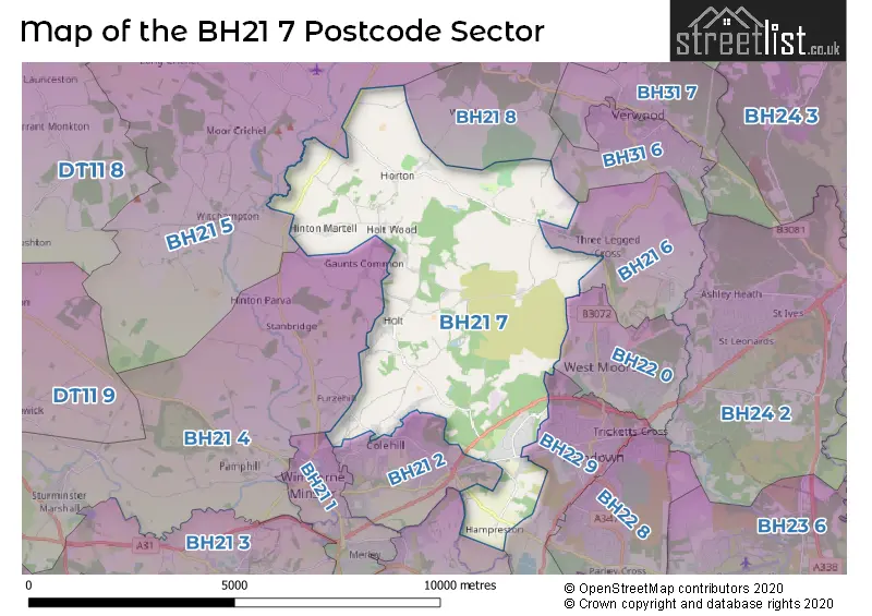
The BH21 7 Postcode shares a border with BH21 1 (WIMBORNE), BH31 6 (VERWOOD, Ebblake Industrial Estate), BH21 2 (WIMBORNE, Colehill), BH21 3 (Corfe Mullen, WIMBORNE, Canford Magna), BH21 4 (Sturminster Marshall, Wimborne Minster, WIMBORNE), BH21 5 (Cranborne, Witchampton, Wimborne St. Giles), BH21 6 (Three Legged Cross, West Moors), BH21 8 (Woodlands, Sutton), BH22 0 (West Moors) and BH22 9 (FERNDOWN).
Map of the BH21 7 Postcode Sector
Explore the BH21 7 postcode sector by using our interactive map.
The sector is within the post town of WIMBORNE.
BH21 7 is a postcode sector within the BH21 postcode district which is within the BH Bournemouth postcode area.
The Royal Mail delivery office for the BH21 7 postal sector is the Wimborne Delivery Office.
The area of the BH21 7 postcode sector is 16.28 square miles which is 42.16 square kilometres or 10,418.18 square acres.
The BH21 7 postcode sector is crossed by the A31 Major A road.
Waterways within the BH21 7 postcode sector include the Stour.
Your support helps keep this site running!
If you enjoy using this website, consider buying me a coffee to help cover hosting costs.


| B | H | 2 | 1 | - | 7 | X | X |
| B | H | 2 | 1 | Space | 7 | Letter | Letter |
Official List of Streets
WIMBORNE (29 Streets)
(9 Streets)
Holt (17 Streets)
Mannington (1 Streets)
Ferndown Industrial Estate (9 Streets)
Horton (8 Streets)
Pilford (1 Streets)
Chalbury (2 Streets)
Hinton Martell (1 Streets)
Unofficial Streets or Alternative Spellings
WIMBORNE
GREENHILL ROAD PILFORD HEATH ROAD SANDY LANEFERNDOWN,
HAM LANE POMPEYS LANEWimborne Minster
BEECH WAY BELLFLOWER ROADThree Legged Cross
HOLT ROAD HORTON ROAD WEST MOORS ROADGaunts
PETERSHAM LANEWoodlands
HORTON ROADWeather Forecast for BH21 7
Weather Forecast for Highbury Garden (West Moors)
| Time Period | Icon | Description | Temperature | Rain Probability | Wind |
|---|---|---|---|---|---|
| 09:00 to 12:00 | Overcast | 7.0°C (feels like 5.0°C) | 15.00% | S 7 mph | |
| 12:00 to 15:00 | Partly cloudy (day) | 10.0°C (feels like 9.0°C) | 10.00% | SW 9 mph | |
| 15:00 to 18:00 | Partly cloudy (day) | 10.0°C (feels like 8.0°C) | 2.00% | SW 9 mph | |
| 18:00 to 21:00 | Cloudy | 7.0°C (feels like 6.0°C) | 7.00% | SSW 7 mph | |
| 21:00 to 00:00 | Cloudy | 8.0°C (feels like 6.0°C) | 7.00% | SSW 7 mph |
| Time Period | Icon | Description | Temperature | Rain Probability | Wind |
|---|---|---|---|---|---|
| 00:00 to 03:00 | Cloudy | 8.0°C (feels like 6.0°C) | 8.00% | SSW 9 mph | |
| 03:00 to 06:00 | Cloudy | 8.0°C (feels like 6.0°C) | 4.00% | SSW 9 mph | |
| 06:00 to 09:00 | Cloudy | 8.0°C (feels like 5.0°C) | 4.00% | SSW 11 mph | |
| 09:00 to 12:00 | Cloudy | 9.0°C (feels like 6.0°C) | 5.00% | SSW 13 mph | |
| 12:00 to 15:00 | Cloudy | 10.0°C (feels like 7.0°C) | 8.00% | SSW 16 mph | |
| 15:00 to 18:00 | Heavy rain | 10.0°C (feels like 7.0°C) | 86.00% | SSW 16 mph | |
| 18:00 to 21:00 | Heavy rain shower (night) | 9.0°C (feels like 7.0°C) | 88.00% | WSW 9 mph | |
| 21:00 to 00:00 | Clear night | 7.0°C (feels like 5.0°C) | 4.00% | WSW 7 mph |
| Time Period | Icon | Description | Temperature | Rain Probability | Wind |
|---|---|---|---|---|---|
| 00:00 to 03:00 | Clear night | 5.0°C (feels like 3.0°C) | 0.00% | WSW 7 mph | |
| 03:00 to 06:00 | Clear night | 4.0°C (feels like 2.0°C) | 0.00% | W 7 mph | |
| 06:00 to 09:00 | Clear night | 3.0°C (feels like 1.0°C) | 1.00% | W 4 mph | |
| 09:00 to 12:00 | Cloudy | 5.0°C (feels like 3.0°C) | 4.00% | W 4 mph | |
| 12:00 to 15:00 | Cloudy | 9.0°C (feels like 8.0°C) | 5.00% | WNW 4 mph | |
| 15:00 to 18:00 | Cloudy | 9.0°C (feels like 8.0°C) | 5.00% | NNW 7 mph | |
| 18:00 to 21:00 | Cloudy | 6.0°C (feels like 4.0°C) | 4.00% | N 4 mph | |
| 21:00 to 00:00 | Cloudy | 4.0°C (feels like 2.0°C) | 4.00% | NNE 4 mph |
| Time Period | Icon | Description | Temperature | Rain Probability | Wind |
|---|---|---|---|---|---|
| 00:00 to 03:00 | Cloudy | 3.0°C (feels like 1.0°C) | 4.00% | NNE 7 mph | |
| 03:00 to 06:00 | Partly cloudy (night) | 3.0°C (feels like 0.0°C) | 1.00% | NE 7 mph | |
| 06:00 to 09:00 | Clear night | 2.0°C (feels like -1.0°C) | 1.00% | NE 7 mph | |
| 09:00 to 12:00 | Sunny day | 3.0°C (feels like 0.0°C) | 0.00% | NE 9 mph | |
| 12:00 to 15:00 | Sunny day | 7.0°C (feels like 4.0°C) | 1.00% | ENE 9 mph | |
| 15:00 to 18:00 | Sunny day | 8.0°C (feels like 5.0°C) | 2.00% | ENE 9 mph | |
| 18:00 to 21:00 | Clear night | 5.0°C (feels like 2.0°C) | 1.00% | ENE 9 mph | |
| 21:00 to 00:00 | Clear night | 4.0°C (feels like 0.0°C) | 2.00% | ENE 9 mph |
| Time Period | Icon | Description | Temperature | Rain Probability | Wind |
|---|---|---|---|---|---|
| 00:00 to 03:00 | Clear night | 3.0°C (feels like -1.0°C) | 1.00% | NE 9 mph | |
| 03:00 to 06:00 | Clear night | 2.0°C (feels like -2.0°C) | 2.00% | NE 9 mph | |
| 06:00 to 09:00 | Cloudy | 2.0°C (feels like -2.0°C) | 5.00% | NE 9 mph | |
| 09:00 to 12:00 | Cloudy | 3.0°C (feels like -1.0°C) | 5.00% | NE 11 mph | |
| 12:00 to 15:00 | Overcast | 6.0°C (feels like 2.0°C) | 7.00% | NE 11 mph | |
| 15:00 to 18:00 | Sunny day | 6.0°C (feels like 3.0°C) | 2.00% | NE 11 mph | |
| 18:00 to 21:00 | Clear night | 4.0°C (feels like 1.0°C) | 2.00% | NE 9 mph | |
| 21:00 to 00:00 | Clear night | 3.0°C (feels like -1.0°C) | 2.00% | NE 9 mph |
Schools and Places of Education Within the BH21 7 Postcode Sector
Hampreston Church of England Voluntary Aided First School
Voluntary aided school
Hampreston Village, Wimborne, Dorset, BH21 7LX
Head: Mr Tim Williams
Ofsted Rating: Outstanding
Inspection: 2013-05-02 (4295 days ago)
Website: Visit Hampreston Church of England Voluntary Aided First School Website
Phone: 01202573074
Number of Pupils: 143
St Michael's Church of England Middle School, Colehill
Academy converter
Colehill Lane, Wimborne, Dorset, BH21 7AB
Head: Mr Darren Ayling
Ofsted Rating: Good
Inspection: 2018-02-01 (2559 days ago)
Website: Visit St Michael's Church of England Middle School, Colehill Website
Phone: 01202883433
Number of Pupils: 604
House Prices in the BH21 7 Postcode Sector
| Type of Property | 2018 Average | 2018 Sales | 2017 Average | 2017 Sales | 2016 Average | 2016 Sales | 2015 Average | 2015 Sales |
|---|---|---|---|---|---|---|---|---|
| Detached | £638,005 | 31 | £638,219 | 47 | £560,158 | 30 | £523,685 | 40 |
| Semi-Detached | £354,500 | 8 | £313,833 | 6 | £374,600 | 5 | £337,583 | 6 |
| Terraced | £198,750 | 2 | £364,167 | 3 | £405,833 | 6 | £390,000 | 1 |
| Flats | £163,000 | 1 | £0 | 0 | £0 | 0 | £152,000 | 1 |
Important Postcodes BH21 7 in the Postcode Sector
BH21 7AB is the postcode for St. Michaels Middle School, Colehill Lane, and DANCE STUDIO & CHANGING FACILITIES, St. Michaels Middle School, Colehill Lane
| The BH21 7 Sector is within these Local Authorities |
|
|---|---|
| The BH21 7 Sector is within these Counties |
|
| The BH21 7 Sector is within these Water Company Areas |
|