A wide range of spatial data has been analysed to present this overview of the BH20 6 Postcode sector. If you would like anything added, please contact us.
The BH20 6 postcode sector is within the county of Dorset.
Did you know? According to the 2021 Census, the BH20 6 postcode sector is home to a bustling 5,909 residents!
Given that each sector allows for 400 unique postcode combinations. Letters C, I, K, M, O and V are not allowed in the last two letters of a postcode. With 152 postcodes already in use, this leaves 248 units available.
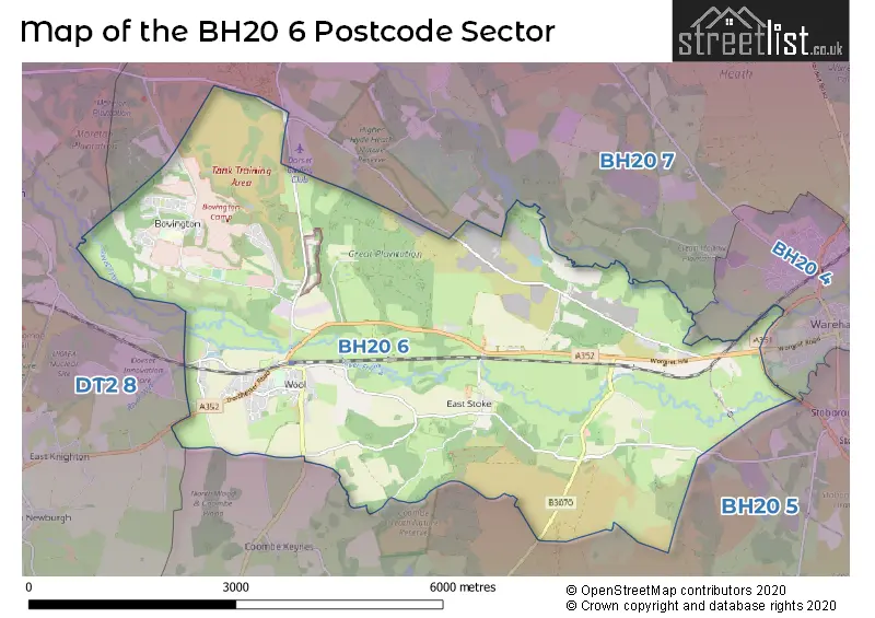
The largest settlement in the BH20 6 postal code is Wool followed by Bovington, and East Stoke.
The BH20 6 Postcode shares a border with BH20 4 (WAREHAM, Northport), BH20 5 (Corfe Castle, WAREHAM, West Lulworth), BH20 7 (Bere Regis, Sandford, WAREHAM) and DT2 8 (Crossways, Broadmayne, Puddletown).
Map of the BH20 6 Postcode Sector
Explore the BH20 6 postcode sector by using our interactive map.
The sector is within the post town of WAREHAM.
BH20 6 is a postcode sector within the BH20 postcode district which is within the BH Bournemouth postcode area.
The Royal Mail delivery office for the BH20 6 postal sector is the Wareham Delivery Office and Wool Scale Payment Delivery Office.
The area of the BH20 6 postcode sector is 13.45 square miles which is 34.83 square kilometres or 8,605.63 square acres.
Waterways within the BH20 6 postcode sector include the River Frome, River Piddle.
Your support helps keep this site running!
If you enjoy using this website, consider buying me a coffee to help cover hosting costs.


| B | H | 2 | 0 | - | 6 | X | X |
| B | H | 2 | 0 | Space | 6 | Letter | Letter |
Official List of Streets
Bovington (31 Streets)
(27 Streets)
Wool (58 Streets)
East Stoke (6 Streets)
Binnegar (2 Streets)
Unofficial Streets or Alternative Spellings
Hyde
PUDDLETOWN ROADWeather Forecast for BH20 6
Weather Forecast for Wareham
| Time Period | Icon | Description | Temperature | Rain Probability | Wind |
|---|---|---|---|---|---|
| 03:00 to 06:00 | Clear night | 3.0°C (feels like 0.0°C) | 0.00% | NE 7 mph | |
| 06:00 to 09:00 | Clear night | 2.0°C (feels like -1.0°C) | 0.00% | NE 7 mph | |
| 09:00 to 12:00 | Sunny day | 3.0°C (feels like 0.0°C) | 0.00% | NE 9 mph | |
| 12:00 to 15:00 | Sunny day | 7.0°C (feels like 4.0°C) | 0.00% | ENE 11 mph | |
| 15:00 to 18:00 | Partly cloudy (day) | 8.0°C (feels like 4.0°C) | 4.00% | ENE 13 mph | |
| 18:00 to 21:00 | Cloudy | 6.0°C (feels like 3.0°C) | 4.00% | ENE 11 mph | |
| 21:00 to 00:00 | Clear night | 4.0°C (feels like 0.0°C) | 0.00% | NE 13 mph |
| Time Period | Icon | Description | Temperature | Rain Probability | Wind |
|---|---|---|---|---|---|
| 00:00 to 03:00 | Partly cloudy (night) | 4.0°C (feels like -1.0°C) | 1.00% | NE 13 mph | |
| 03:00 to 06:00 | Clear night | 3.0°C (feels like -1.0°C) | 0.00% | NE 13 mph | |
| 06:00 to 09:00 | Cloudy | 3.0°C (feels like -2.0°C) | 3.00% | NE 16 mph | |
| 09:00 to 12:00 | Cloudy | 4.0°C (feels like -1.0°C) | 4.00% | NE 16 mph | |
| 12:00 to 15:00 | Cloudy | 5.0°C (feels like 0.0°C) | 5.00% | NE 18 mph | |
| 15:00 to 18:00 | Overcast | 5.0°C (feels like 1.0°C) | 10.00% | NE 18 mph | |
| 18:00 to 21:00 | Overcast | 4.0°C (feels like 0.0°C) | 9.00% | NE 16 mph | |
| 21:00 to 00:00 | Overcast | 3.0°C (feels like -1.0°C) | 9.00% | NNE 16 mph |
| Time Period | Icon | Description | Temperature | Rain Probability | Wind |
|---|---|---|---|---|---|
| 00:00 to 03:00 | Overcast | 3.0°C (feels like -1.0°C) | 10.00% | NNE 13 mph | |
| 03:00 to 06:00 | Overcast | 3.0°C (feels like -1.0°C) | 9.00% | NNE 11 mph | |
| 06:00 to 09:00 | Overcast | 3.0°C (feels like -1.0°C) | 10.00% | N 11 mph | |
| 09:00 to 12:00 | Overcast | 3.0°C (feels like -1.0°C) | 12.00% | N 11 mph | |
| 12:00 to 15:00 | Overcast | 5.0°C (feels like 1.0°C) | 12.00% | NNE 11 mph | |
| 15:00 to 18:00 | Cloudy | 5.0°C (feels like 2.0°C) | 7.00% | NNE 9 mph | |
| 18:00 to 21:00 | Cloudy | 4.0°C (feels like 1.0°C) | 7.00% | N 9 mph | |
| 21:00 to 00:00 | Overcast | 4.0°C (feels like 1.0°C) | 10.00% | N 9 mph |
| Time Period | Icon | Description | Temperature | Rain Probability | Wind |
|---|---|---|---|---|---|
| 00:00 to 03:00 | Overcast | 4.0°C (feels like 1.0°C) | 10.00% | NNE 9 mph | |
| 03:00 to 06:00 | Overcast | 4.0°C (feels like 0.0°C) | 8.00% | NNE 9 mph | |
| 06:00 to 09:00 | Cloudy | 4.0°C (feels like 0.0°C) | 6.00% | NNE 11 mph | |
| 09:00 to 12:00 | Cloudy | 4.0°C (feels like 0.0°C) | 11.00% | NE 13 mph | |
| 12:00 to 15:00 | Cloudy | 6.0°C (feels like 2.0°C) | 9.00% | NE 13 mph | |
| 15:00 to 18:00 | Cloudy | 7.0°C (feels like 3.0°C) | 9.00% | NE 13 mph | |
| 18:00 to 21:00 | Cloudy | 6.0°C (feels like 2.0°C) | 8.00% | NE 13 mph | |
| 21:00 to 00:00 | Overcast | 5.0°C (feels like 1.0°C) | 11.00% | NE 16 mph |
Schools and Places of Education Within the BH20 6 Postcode Sector
Bovington Academy
Academy sponsor led
Holt Road, Wareham, Dorset, BH20 6LE
Head: Ms Sara White
Ofsted Rating: Good
Inspection: 2023-10-18 (477 days ago)
Website: Visit Bovington Academy Website
Phone: 01929462744
Number of Pupils: 202
Harbour School Dorset
Free schools special
School Road, , , BH20 6NU
Head: Mr Daniel Butt
Ofsted Rating: Good
Inspection: 2023-10-11 (484 days ago)
Website: Visit Harbour School Dorset Website
Phone: 01929508286
Number of Pupils: 81
St Mary & St Joseph's Catholic Primary School
Academy converter
Folly Lane, Wareham, Dorset, BH20 6DS
Head: Mrs Sarah Terrey
Ofsted Rating: Requires improvement
Inspection: 2020-01-30 (1834 days ago)
Website: Visit St Mary & St Joseph's Catholic Primary School Website
Phone: 01929462565
Number of Pupils: 153
Wool Church of England Primary School
Academy sponsor led
High Street, Wareham, Dorset, BH20 6BT
Head: Mrs Eleanor Griffiths
Ofsted Rating: Good
Inspection: 2023-10-18 (477 days ago)
Website: Visit Wool Church of England Primary School Website
Phone: 01929462569
Number of Pupils: 100
House Prices in the BH20 6 Postcode Sector
| Type of Property | 2018 Average | 2018 Sales | 2017 Average | 2017 Sales | 2016 Average | 2016 Sales | 2015 Average | 2015 Sales |
|---|---|---|---|---|---|---|---|---|
| Detached | £387,200 | 35 | £399,491 | 29 | £347,855 | 31 | £351,137 | 26 |
| Semi-Detached | £283,231 | 26 | £267,833 | 21 | £221,348 | 23 | £235,225 | 20 |
| Terraced | £230,576 | 23 | £231,398 | 20 | £215,947 | 19 | £197,825 | 20 |
| Flats | £151,833 | 6 | £148,333 | 9 | £132,700 | 5 | £130,833 | 6 |
Important Postcodes BH20 6 in the Postcode Sector
BH20 6BT is the postcode for Wool C Of E Primary School, High Street
BH20 6DS is the postcode for St. Mary and St. Josephs Catholic Primary School, Folly Lane, ST MARYS PRIMARY SCHOOL, FOLLY LANE, WOOL, and St. Mary and St. Josephs Catholic Primary School, Folly Lane, Wool
BH20 6JB is the postcode for Ministry of Defence, Stanley Barracks,
BH20 6JG is the postcode for Ministry of Defence, R A C Tank Museum,
BH20 6JQ is the postcode for Vision Youth Club, Memorial Hall, King George V Road
BH20 6LE is the postcode for Bovington First School, Holt Road, and Bovington Academy, Holt Road
BH20 6NU is the postcode for Bovington Middle School, Cologne Road
| The BH20 6 Sector is within these Local Authorities |
|
|---|---|
| The BH20 6 Sector is within these Counties |
|
| The BH20 6 Sector is within these Water Company Areas |
|
Tourist Attractions within the BH20 6 Postcode Area
We found 1 visitor attractions within the BH20 postcode area
| The Tank Museum |
|---|
| Museums & Art Galleries |
| Museum and / or Art Gallery |
| View The Tank Museum on Google Maps |