A wide range of spatial data has been analysed to present this overview of the BH2 5 Postcode sector. If you would like anything added, please contact us.
The BH2 5 postcode sector is within the county of Dorset.
Did you know? According to the 2021 Census, the BH2 5 postcode sector is home to a bustling 4,896 residents!
Given that each sector allows for 400 unique postcode combinations. Letters C, I, K, M, O and V are not allowed in the last two letters of a postcode. With 157 postcodes already in use, this leaves 243 units available.
The BH2 5 postal code covers the settlement of BOURNEMOUTH.
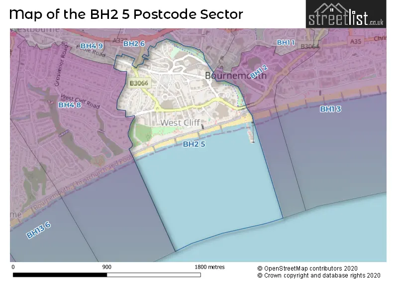
The BH2 5 Postcode shares a border with BH1 2 (BOURNEMOUTH), BH2 6 (BOURNEMOUTH), BH4 8 (BOURNEMOUTH) and BH4 9 (BOURNEMOUTH).
Map of the BH2 5 Postcode Sector
Explore the BH2 5 postcode sector by using our interactive map.
The sector is within the post town of BOURNEMOUTH.
BH2 5 is a postcode sector within the BH2 postcode district which is within the BH Bournemouth postcode area.
The Royal Mail delivery office for the BH2 5 postal sector is the Bournemouth Delivery Office.
The area of the BH2 5 postcode sector is 0.34 square miles which is 0.88 square kilometres or 217.48 square acres.
Waterways within the BH2 5 postcode sector include the River Bourne.
Your support helps keep this site running!
If you enjoy using this website, consider buying me a coffee to help cover hosting costs.


| B | H | 2 | - | 5 | X | X |
| B | H | 2 | Space | 5 | Letter | Letter |
Official List of Streets
BOURNEMOUTH (46 Streets)
Unofficial Streets or Alternative Spellings
BOURNEMOUTH
BATH ROAD BOURNE AVENUE CAMBRIDGE ROAD GERVIS PLACE MARLBOROUGH ROAD THE SQUARE WEST OVERCLIFF DRIVE BIC ROUNDABOUT DURLEY ROUNDABOUT SAINT MICHAELS ROAD ST MICHAELS ROUNDABOUT THE MEWS WEST CLIFF PROMENADE WESTOVER STEPS WINTER GARDENS APPROACHWestbourne
WEST CLIFF ROADBranksome
POOLE ROADWeather Forecast for BH2 5
Weather Forecast for Bournemouth - Durley Chine (Beach)
| Time Period | Icon | Description | Temperature | Rain Probability | Wind |
|---|---|---|---|---|---|
| 18:00 to 21:00 | Clear night | 5.0°C (feels like 3.0°C) | 0.00% | WNW 7 mph | |
| 21:00 to 00:00 | Clear night | 3.0°C (feels like 0.0°C) | 0.00% | W 4 mph |
| Time Period | Icon | Description | Temperature | Rain Probability | Wind |
|---|---|---|---|---|---|
| 00:00 to 03:00 | Clear night | 3.0°C (feels like 0.0°C) | 2.00% | WSW 7 mph | |
| 03:00 to 06:00 | Cloudy | 6.0°C (feels like 3.0°C) | 57.00% | SW 9 mph | |
| 06:00 to 09:00 | Heavy rain | 7.0°C (feels like 3.0°C) | 89.00% | SW 13 mph | |
| 09:00 to 12:00 | Light rain shower (day) | 7.0°C (feels like 4.0°C) | 42.00% | W 11 mph | |
| 12:00 to 15:00 | Cloudy | 9.0°C (feels like 6.0°C) | 7.00% | NNW 11 mph | |
| 15:00 to 18:00 | Cloudy | 9.0°C (feels like 7.0°C) | 6.00% | NNE 9 mph | |
| 18:00 to 21:00 | Cloudy | 7.0°C (feels like 5.0°C) | 7.00% | NNE 7 mph | |
| 21:00 to 00:00 | Cloudy | 6.0°C (feels like 4.0°C) | 6.00% | NE 7 mph |
| Time Period | Icon | Description | Temperature | Rain Probability | Wind |
|---|---|---|---|---|---|
| 00:00 to 03:00 | Overcast | 6.0°C (feels like 4.0°C) | 9.00% | ENE 7 mph | |
| 03:00 to 06:00 | Overcast | 6.0°C (feels like 4.0°C) | 10.00% | E 7 mph | |
| 06:00 to 09:00 | Overcast | 6.0°C (feels like 4.0°C) | 9.00% | ESE 9 mph | |
| 09:00 to 12:00 | Overcast | 6.0°C (feels like 4.0°C) | 9.00% | SE 9 mph | |
| 12:00 to 15:00 | Overcast | 7.0°C (feels like 4.0°C) | 8.00% | SSE 11 mph | |
| 15:00 to 18:00 | Partly cloudy (day) | 7.0°C (feels like 4.0°C) | 2.00% | SSE 11 mph | |
| 18:00 to 21:00 | Overcast | 6.0°C (feels like 3.0°C) | 7.00% | SSE 11 mph | |
| 21:00 to 00:00 | Cloudy | 6.0°C (feels like 3.0°C) | 5.00% | SSE 11 mph |
| Time Period | Icon | Description | Temperature | Rain Probability | Wind |
|---|---|---|---|---|---|
| 00:00 to 03:00 | Cloudy | 6.0°C (feels like 3.0°C) | 6.00% | S 13 mph | |
| 03:00 to 06:00 | Overcast | 6.0°C (feels like 3.0°C) | 11.00% | S 13 mph | |
| 06:00 to 09:00 | Cloudy | 6.0°C (feels like 2.0°C) | 10.00% | S 13 mph | |
| 09:00 to 12:00 | Cloudy | 6.0°C (feels like 3.0°C) | 15.00% | S 11 mph | |
| 12:00 to 15:00 | Sunny day | 7.0°C (feels like 5.0°C) | 12.00% | SSW 11 mph | |
| 15:00 to 18:00 | Sunny day | 8.0°C (feels like 5.0°C) | 9.00% | SSW 9 mph | |
| 18:00 to 21:00 | Clear night | 6.0°C (feels like 3.0°C) | 4.00% | S 7 mph | |
| 21:00 to 00:00 | Partly cloudy (night) | 5.0°C (feels like 2.0°C) | 3.00% | SE 7 mph |
| Time Period | Icon | Description | Temperature | Rain Probability | Wind |
|---|---|---|---|---|---|
| 00:00 to 03:00 | Partly cloudy (night) | 5.0°C (feels like 2.0°C) | 2.00% | S 7 mph | |
| 03:00 to 06:00 | Partly cloudy (night) | 5.0°C (feels like 2.0°C) | 3.00% | W 7 mph | |
| 06:00 to 09:00 | Cloudy | 4.0°C (feels like 2.0°C) | 6.00% | ESE 7 mph | |
| 09:00 to 12:00 | Mist | 5.0°C (feels like 3.0°C) | 13.00% | SSE 9 mph | |
| 12:00 to 15:00 | Cloudy | 7.0°C (feels like 5.0°C) | 6.00% | S 11 mph | |
| 15:00 to 18:00 | Cloudy | 8.0°C (feels like 5.0°C) | 5.00% | S 11 mph | |
| 18:00 to 21:00 | Cloudy | 7.0°C (feels like 4.0°C) | 6.00% | S 13 mph | |
| 21:00 to 00:00 | Cloudy | 7.0°C (feels like 4.0°C) | 6.00% | S 16 mph |
Schools and Places of Education Within the BH2 5 Postcode Sector
St Michael's Church of England Primary School
Academy converter
Somerville Road, Bournemouth, Dorset, BH2 5LH
Head: Mr Anthony Evans
Ofsted Rating: Good
Inspection: 2019-02-12 (2179 days ago)
Website: Visit St Michael's Church of England Primary School Website
Phone: 01202290497
Number of Pupils: 627
House Prices in the BH2 5 Postcode Sector
| Type of Property | 2018 Average | 2018 Sales | 2017 Average | 2017 Sales | 2016 Average | 2016 Sales | 2015 Average | 2015 Sales |
|---|---|---|---|---|---|---|---|---|
| Detached | £472,500 | 2 | £335,500 | 2 | £690,000 | 2 | £0 | 0 |
| Semi-Detached | £240,000 | 1 | £295,000 | 2 | £535,000 | 2 | £0 | 0 |
| Terraced | £274,190 | 5 | £303,071 | 7 | £288,357 | 11 | £257,992 | 6 |
| Flats | £186,790 | 170 | £232,813 | 212 | £213,713 | 206 | £167,181 | 142 |
Important Postcodes BH2 5 in the Postcode Sector
BH2 5BH is the postcode for Bournemouth International Centre, Exeter Road, and BOURNEMOUTH INTERNATIONAL CENTRE, EXETER ROAD, BOURNEMOUTH
BH2 5JW is the postcode for Hahnemann House, Hahnemann Road
BH2 5LH is the postcode for St Michael's Church Of England Primary School, Somerville Road, ST MICHAEL'S CHURCH OF ENGLAND PRIMARY SCHOOL, SOMERVILLE ROAD, BOURNEMOUTH, and St. Michael's C of E School, Somerville Road
BH2 5RQ is the postcode for The Bournemouth Library, 22 The Triangle
| The BH2 5 Sector is within these Local Authorities |
|
|---|---|
| The BH2 5 Sector is within these Counties |
|
| The BH2 5 Sector is within these Water Company Areas |
|