A wide range of spatial data has been analysed to present this overview of the BH10 7 Postcode sector. If you would like anything added, please contact us.
The BH10 7 postcode sector is within the county of Dorset.
Did you know? According to the 2021 Census, the BH10 7 postcode sector is home to a bustling 3,911 residents!
Given that each sector allows for 400 unique postcode combinations. Letters C, I, K, M, O and V are not allowed in the last two letters of a postcode. With 113 postcodes already in use, this leaves 287 units available.
The largest settlements in the BH10 7 postal code are BOURNEMOUTH and Northbourne.
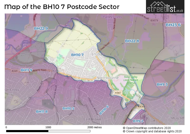
The BH10 7 Postcode shares a border with BH9 2 (BOURNEMOUTH), BH9 3 (BOURNEMOUTH), BH10 5 (BOURNEMOUTH), BH10 6 (BOURNEMOUTH), BH11 9 (BOURNEMOUTH, Bearwood), BH22 8 (FERNDOWN, West Parley) and BH22 9 (FERNDOWN).
Map of the BH10 7 Postcode Sector
Explore the BH10 7 postcode sector by using our interactive map.
The sector is within the post town of BOURNEMOUTH.
BH10 7 is a postcode sector within the BH10 postcode district which is within the BH Bournemouth postcode area.
The Royal Mail delivery office for the BH10 7 postal sector is the Winton Delivery Office.
The area of the BH10 7 postcode sector is 0.87 square miles which is 2.24 square kilometres or 554.72 square acres.
Waterways within the BH10 7 postcode sector include the Stour.
Your support helps keep this site running!
If you enjoy using this website, consider buying me a coffee to help cover hosting costs.


| B | H | 1 | 0 | - | 7 | X | X |
| B | H | 1 | 0 | Space | 7 | Letter | Letter |
Official List of Streets
BOURNEMOUTH (43 Streets)
Northbourne (2 Streets)
Unofficial Streets or Alternative Spellings
BOURNEMOUTH
ASHRIDGE AVENUE BRIERLEY ROAD EAST HOWE LANE FERNCROFT ROAD GLAMIS AVENUE HEADSWELL AVENUE HOME ROAD KITSCROFT ROAD LAKE ROAD NORTHBOURNE AVENUE PINE VALE CRESCENT PINEWOOD AVENUE PINEWOOD CLOSE REDHILL AVENUE REDHILL DRIVE SAXONHURST CLOSE SAXONHURST ROAD TRUMAN ROADWest Parley
NEW ROADWeather Forecast for BH10 7
Weather Forecast for Kinson
| Time Period | Icon | Description | Temperature | Rain Probability | Wind |
|---|---|---|---|---|---|
| 15:00 to 18:00 | Light rain shower (day) | 12.0°C (feels like 9.0°C) | 36.00% | W 18 mph | |
| 18:00 to 21:00 | Partly cloudy (night) | 10.0°C (feels like 6.0°C) | 2.00% | W 16 mph | |
| 21:00 to 00:00 | Partly cloudy (night) | 9.0°C (feels like 5.0°C) | 4.00% | W 16 mph |
| Time Period | Icon | Description | Temperature | Rain Probability | Wind |
|---|---|---|---|---|---|
| 00:00 to 03:00 | Partly cloudy (night) | 8.0°C (feels like 4.0°C) | 8.00% | W 16 mph | |
| 03:00 to 06:00 | Heavy rain shower (night) | 6.0°C (feels like 2.0°C) | 61.00% | W 20 mph | |
| 06:00 to 09:00 | Light rain shower (night) | 5.0°C (feels like 0.0°C) | 43.00% | W 18 mph | |
| 09:00 to 12:00 | Light rain shower (day) | 5.0°C (feels like 0.0°C) | 44.00% | WNW 18 mph | |
| 12:00 to 15:00 | Partly cloudy (day) | 6.0°C (feels like 2.0°C) | 32.00% | WNW 20 mph | |
| 15:00 to 18:00 | Partly cloudy (day) | 7.0°C (feels like 2.0°C) | 4.00% | WNW 20 mph | |
| 18:00 to 21:00 | Clear night | 6.0°C (feels like 1.0°C) | 2.00% | WNW 20 mph | |
| 21:00 to 00:00 | Clear night | 6.0°C (feels like 1.0°C) | 1.00% | NW 20 mph |
| Time Period | Icon | Description | Temperature | Rain Probability | Wind |
|---|---|---|---|---|---|
| 00:00 to 03:00 | Clear night | 6.0°C (feels like 1.0°C) | 1.00% | NW 20 mph | |
| 03:00 to 06:00 | Clear night | 6.0°C (feels like 1.0°C) | 2.00% | NW 18 mph | |
| 06:00 to 09:00 | Clear night | 6.0°C (feels like 2.0°C) | 1.00% | NW 16 mph | |
| 09:00 to 12:00 | Sunny day | 6.0°C (feels like 2.0°C) | 1.00% | NW 13 mph | |
| 12:00 to 15:00 | Partly cloudy (day) | 8.0°C (feels like 5.0°C) | 2.00% | NW 11 mph | |
| 15:00 to 18:00 | Cloudy | 8.0°C (feels like 5.0°C) | 5.00% | WNW 9 mph | |
| 18:00 to 21:00 | Cloudy | 7.0°C (feels like 5.0°C) | 7.00% | W 7 mph | |
| 21:00 to 00:00 | Overcast | 7.0°C (feels like 5.0°C) | 14.00% | WSW 7 mph |
| Time Period | Icon | Description | Temperature | Rain Probability | Wind |
|---|---|---|---|---|---|
| 00:00 to 03:00 | Overcast | 9.0°C (feels like 7.0°C) | 15.00% | WSW 9 mph | |
| 03:00 to 06:00 | Overcast | 10.0°C (feels like 8.0°C) | 13.00% | W 9 mph | |
| 06:00 to 09:00 | Overcast | 11.0°C (feels like 9.0°C) | 12.00% | W 9 mph | |
| 09:00 to 12:00 | Overcast | 11.0°C (feels like 9.0°C) | 11.00% | W 9 mph | |
| 12:00 to 15:00 | Overcast | 12.0°C (feels like 10.0°C) | 9.00% | WNW 9 mph | |
| 15:00 to 18:00 | Overcast | 12.0°C (feels like 11.0°C) | 11.00% | WNW 9 mph | |
| 18:00 to 21:00 | Overcast | 11.0°C (feels like 10.0°C) | 12.00% | W 7 mph | |
| 21:00 to 00:00 | Overcast | 11.0°C (feels like 9.0°C) | 11.00% | W 9 mph |
| Time Period | Icon | Description | Temperature | Rain Probability | Wind |
|---|---|---|---|---|---|
| 00:00 to 03:00 | Overcast | 10.0°C (feels like 9.0°C) | 12.00% | W 7 mph | |
| 03:00 to 06:00 | Overcast | 10.0°C (feels like 9.0°C) | 12.00% | W 7 mph | |
| 06:00 to 09:00 | Overcast | 10.0°C (feels like 8.0°C) | 11.00% | W 7 mph | |
| 09:00 to 12:00 | Overcast | 10.0°C (feels like 9.0°C) | 10.00% | W 7 mph | |
| 12:00 to 15:00 | Overcast | 11.0°C (feels like 10.0°C) | 11.00% | W 7 mph | |
| 15:00 to 18:00 | Cloudy | 11.0°C (feels like 10.0°C) | 8.00% | W 4 mph | |
| 18:00 to 21:00 | Overcast | 10.0°C (feels like 9.0°C) | 11.00% | SW 4 mph | |
| 21:00 to 00:00 | Overcast | 9.0°C (feels like 9.0°C) | 11.00% | SW 4 mph |
House Prices in the BH10 7 Postcode Sector
| Type of Property | 2018 Average | 2018 Sales | 2017 Average | 2017 Sales | 2016 Average | 2016 Sales | 2015 Average | 2015 Sales |
|---|---|---|---|---|---|---|---|---|
| Detached | £341,743 | 41 | £311,837 | 31 | £304,447 | 45 | £273,593 | 42 |
| Semi-Detached | £280,075 | 20 | £264,097 | 15 | £247,421 | 14 | £251,346 | 13 |
| Terraced | £272,500 | 12 | £255,000 | 2 | £200,113 | 4 | £193,375 | 4 |
| Flats | £143,667 | 9 | £151,833 | 6 | £175,325 | 6 | £139,615 | 13 |
Important Postcodes BH10 7 in the Postcode Sector
BH10 7AR is the postcode for Northbourne Surgery, 1368 Wimborne Road
BH10 7LF is the postcode for PELHAMS PARK LEISURE CENTRE, MANOR FARM ROAD, BOURNEMOUTH, and Pelhams Leisure Centre, Manor Farm Road
BH10 7LH is the postcode for Pelhams Clinic, Pelhams Park, Millhams Road
| The BH10 7 Sector is within these Local Authorities |
|
|---|---|
| The BH10 7 Sector is within these Counties |
|
| The BH10 7 Sector is within these Water Company Areas |
|