The Ceremonial County of Berkshire in England

The Ceremonial County of Berkshire is situated in South East England.

a map of Berkshire

The area of Berkshire is 488 Square Miles (1,264 Square Kilometres). Making Berkshire the 28th smallest county in Great Britain (out of 91) and the 9th smallest county in England (out of 48).

Berkshire: England's Historic Gem

Berkshire, whose name originates from the Forest of Berroc, where Box trees grow abundantly, derives from the Celtic word 'Berroc', meaning 'Hilly'. This historic county west of London offers a blend of history, natural beauty, and modern charm.

The East: A Royal Legacy

In the east, close to the M25, lie vibrant towns like Slough and Maidenhead, with Windsor standing out for its iconic castle, home to the Royal Family and a top tourist destination. Nearby, Legoland offers fun for all ages.

The West: Rural Peace and Ancient Mysteries

Heading west, the landscape transforms to countryside serenity around Newbury, surrounded by charming villages and the Berkshire Downs, part of the North Wessex Downs Area of Outstanding Natural Beauty. This region is crossed by the ancient Ridgeway, leading to sacred sites like Wayland's Smithy and the White Horse of Uffington, whose origins remain mysterious.

Battles of Berkshire

Berkshire's history is marked by significant battles, particularly during the Civil War. The two Battles of Newbury in 1643 and the siege of Donnington Castle left lasting imprints. Reading, the county town, witnessed the 11-day siege of Reading. Notably, the Battle of Broad Street in 1688 was part of the Glorious Revolution, the last successful invasion of England. This decisive confrontation helped install William of Orange from the Netherlands, replacing King James II (ousting the Stuart reign), and changing the course of British history.

Modern Berkshire: A Hub of Growth

Today, Berkshire is a thriving hub, connected by the M4 motorway, known as the M4 Corridor, home to many hi-tech companies. The River Thames flows through Reading, while the River Kennet weaves through Newbury and beyond, symbolising the county's harmony between past and present.

Berkshire's story is a captivating blend of ancient and modern, waiting to be explored.

Geological Map of Berkshire

A map showing the geology of Berkshire.

Geological Makeup of Berkshire
Map Key Description
28 SAND, SILT AND CLAY
30 CHALK
48 MUDSTONE, SANDSTONE AND LIMESTONE
79 CLAY, SILT, SAND AND GRAVEL
Map of Berkshire

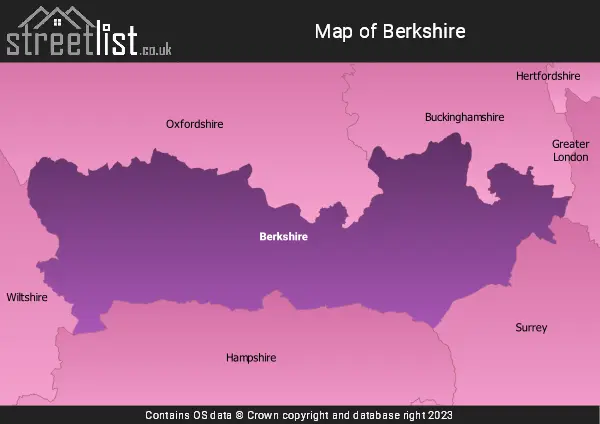
A map showing the boundary of Berkshire in relation to other counties.

Advertisement

Map of the County of Berkshire

Zoom LevelLatitudeLongitude
653.521968-2.164306
Cities, Towns and Villages in Berkshire
Town Name Number of Streets
READING2624
SLOUGH2617
MAIDENHEAD1600
BRACKNELL1440
WOKINGHAM1241
NEWBURY1036
WINDSOR938
Tilehurst885
ASCOT702
Earley597
THATCHAM586
Woodley536
Caversham480
CROWTHORNE472
Warfield397
Binfield393
Finchampstead359
Lower Earley332
Calcot265
Winnersh261
Cookham254
Twyford253
SANDHURST250
Emmer Green232
Shinfield221
North Ascot218
Spencers Wood187
Burghfield Common173
Pangbourne173
Winkfield172
Eton161
Old Windsor151
HUNGERFORD148
Colnbrook143
Theale142
Datchet137
Mortimer137
Three Mile Cross136
Arborfield133
South Ascot129
Wargrave127
Arborfield Green127
Aldermaston126
Lambourn119
Hermitage117
Purley On Thames108
Owlsmoor107
College Town102
Ruscombe99
Bray97
Shaw95
Holyport88
Swallowfield87
Hurst87
Sunninghill86
Kintbury85
Streatley83
Cold Ash83
Arborfield Garrison81
Greenham79
Poyle75
Speen73
Eton Wick73
Donnington72
Sonning68
Winkfield Row68
Hare Hatch68
Inkpen65
Charvil64
Windsor Castle62
Bucklebury62
Burghfield61
Horton61
CAMBERLEY61
Riseley61
Sindlesham60
TADLEY59
Enborne58
Crookham Common58
Compton58
Wraysbury57
Arborfield Cross56
Eton College54
Remenham53
Waltham St. Lawrence52
Barkham52
White Waltham51
Wellington College51
Newell Green50
Knowl Hill48
HENLEY-ON-THAMES48
Sunningdale48
Benham Hill46
Chieveley45
Upper Basildon43
Sulhamstead43
Lambourn Woodlands42
Upper Bucklebury41
Beenham41
Wexham41
Hurley40
Littlewick Green39
Southend38
STAINES-UPON-THAMES36
Shurlock Row36
Henwick35
Whiteknights35
MARLOW34
Bradfield Southend34
Oakley Green34
Aldermaston Wharf34
Great Shefford33
Yattendon33
Brimpton33
Mortimer Common33
Wash Water33
Woodlands St. Mary32
Farley Hill32
Eversley32
Curridge30
Ufton Nervet29
Midgham29
Bradfield29
Warfield Park29
Woolhampton27
Eddington27
Remenham Hill27
Chavey Down26
East Ilsley26
Cheapside25
East Garston25
Grazeley24
Whistley Green23
Longlane23
Lower Green22
Beech Hill22
Taplow22
Hampstead Norreys22
The Village22
Kiln Green21
Lower Basildon21
Finchwood Park19
Stockcross19
Upper Woolhampton19
Sandford18
Padworth18
Beedon17
Tutts Clump17
Frilsham16
Little Hungerford16
Leckhampstead15
Shefford Woodlands15
Bisham14
Crookham14
Chaddleworth14
Ryeish Green13
Stud Green13
Stanford Dingley13
Bishops Green13
West Ilsley13
Brimpton Common12
Grazeley Green12
Chapel Row12
Lower Padworth12
Burchetts Green12
Brightwalton11
Woodspeen10
Padworth Common10
Great Lea Common10
Peasemore10
Boxford9
Wickham9
Billingbear9
West End9
Enborne Row9
Crazies Hill9
Dorney9
Tidmarsh9
Temple8
Royal Military Academy8
Aston8
World's End8
Welford8
Warren Row8
New Town8
Brockhill7
Pamber Heath7
The Holt7
Aldworth7
Winterbourne6
Woolley Green6
Ashampstead6
Catmore6
Ashmore Green6
Marlston Hermitage6
Fifield6
Sulham5
Upper Culham5
Halfway5
Langley Common5
Silchester5
Englefield5
Newtown5
Weston5
Upper Lambourn5
Farnham Royal4
Farnborough4
Hamstead Marshall4
Kintbury Holt4
Lower Denford4
Paley Street4
Crockham Heath3
Bagnor3
Baughurst3
West Woodhay3
Easton3
Inkpen Common3
Eastbury2
Lower Padworth2
North Fawley2
Pingewood2
Heads Hill2
Langley2
Hungerford Park2
Newtown2
Rosehill2
Colthrop2
Ashampstead Common2
Leverton1
Snelsmore Common1
Water Oakley1
Standen1
Hunts Green1
Wickham Heath1
Cold Harbour1
Hoe Benham1
Whatcombe1
Marsh Benham1
Taplow1
Eling Hermitage1
Woolley1