A wide range of spatial data has been analysed to present this overview of the BA12 0 Postcode sector. If you would like anything added, please contact us.
The BA12 0 postcode sector is within the county of Wiltshire.
Did you know? According to the 2021 Census, the BA12 0 postcode sector is home to a bustling 5,536 residents!
Given that each sector allows for 400 unique postcode combinations. Letters C, I, K, M, O and V are not allowed in the last two letters of a postcode. With 227 postcodes already in use, this leaves 173 units available.
The largest settlement in the BA12 0 postal code is WARMINSTER followed by Codford, and Heytesbury.
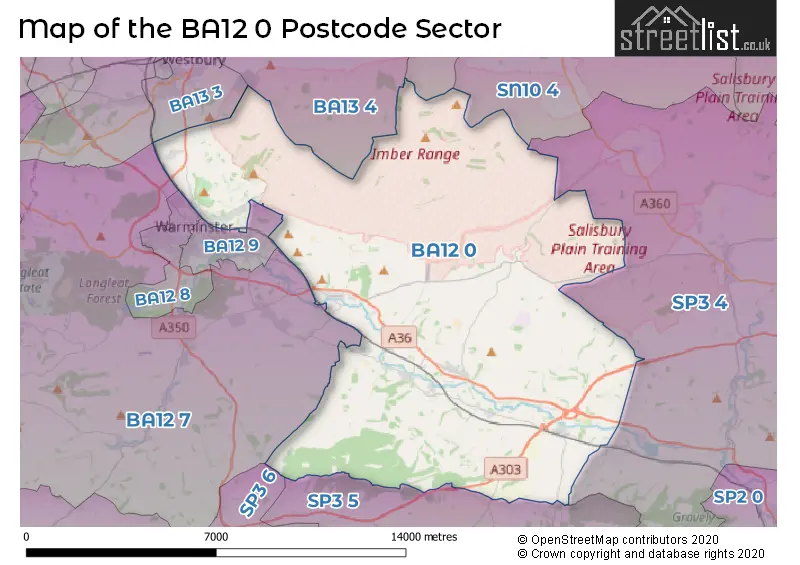
The BA12 0 Postcode shares a border with BA12 7 (Corsley, Sutton Veny, Horningsham), SN10 4 (Market Lavington, Urchfont, West Lavington), SN10 5 (DEVIZES, Potterne, Great Cheverell), SP3 4 (Shrewton, Barford St. Martin, Tilshead), SP3 5 (Dinton, Fovant, Chilmark), SP3 6 (Tisbury, East Knoyle, Hindon), BA12 8 (WARMINSTER, Crockerton), BA12 9 (WARMINSTER, Bishopstrow), BA13 3 (WESTBURY, Dilton Marsh) and BA13 4 (WESTBURY, Dilton Marsh, Bratton).
Map of the BA12 0 Postcode Sector
Explore the BA12 0 postcode sector by using our interactive map.
The sector is within the post town of WARMINSTER.
BA12 0 is a postcode sector within the BA12 postcode district which is within the BA Bath postcode area.
The Royal Mail delivery office for the BA12 0 postal sector is the Warminster Delivery Office.
The area of the BA12 0 postcode sector is 61.96 square miles which is 160.46 square kilometres or 39,651.42 square acres.
The BA12 0 postcode sector is crossed by the A36 Major A road.
The BA12 0 postcode sector is crossed by the A303 Major A road.
Waterways within the BA12 0 postcode sector include the River Wylye.
Your support helps keep this site running!
If you enjoy using this website, consider buying me a coffee to help cover hosting costs.


| B | A | 1 | 2 | - | 0 | X | X |
| B | A | 1 | 2 | Space | 0 | Letter | Letter |
Official List of Streets
Chitterne (8 Streets)
(53 Streets)
Sherrington (1 Streets)
Stockton (2 Streets)
Codford (26 Streets)
WARMINSTER (24 Streets)
Upton Scudamore (5 Streets)
Heytesbury (19 Streets)
Wylye (16 Streets)
Knook (1 Streets)
Upton Lovell (1 Streets)
Corton (1 Streets)
Unofficial Streets or Alternative Spellings
Chilmark
COW DROVEWARMINSTER
BATTLESBURY ROADSteeple Langford
SALISBURY ROADHanging Langford
WYLYE ROADHeytesbury
MILL LANESutton Veny
NORTON ROADWeather Forecast for BA12 0
Weather Forecast for Warminster
| Time Period | Icon | Description | Temperature | Rain Probability | Wind |
|---|---|---|---|---|---|
| 21:00 to 00:00 | Overcast | 5.0°C (feels like 2.0°C) | 9.00% | SSE 11 mph |
| Time Period | Icon | Description | Temperature | Rain Probability | Wind |
|---|---|---|---|---|---|
| 00:00 to 03:00 | Overcast | 5.0°C (feels like 1.0°C) | 9.00% | SSE 11 mph | |
| 03:00 to 06:00 | Overcast | 4.0°C (feels like 1.0°C) | 9.00% | SSE 11 mph | |
| 06:00 to 09:00 | Cloudy | 3.0°C (feels like 0.0°C) | 5.00% | SSE 9 mph | |
| 09:00 to 12:00 | Cloudy | 4.0°C (feels like 0.0°C) | 5.00% | SSE 9 mph | |
| 12:00 to 15:00 | Partly cloudy (day) | 6.0°C (feels like 3.0°C) | 1.00% | SSE 9 mph | |
| 15:00 to 18:00 | Sunny day | 7.0°C (feels like 4.0°C) | 1.00% | S 9 mph | |
| 18:00 to 21:00 | Cloudy | 4.0°C (feels like 1.0°C) | 5.00% | S 4 mph | |
| 21:00 to 00:00 | Partly cloudy (night) | 3.0°C (feels like 1.0°C) | 2.00% | SSE 7 mph |
| Time Period | Icon | Description | Temperature | Rain Probability | Wind |
|---|---|---|---|---|---|
| 00:00 to 03:00 | Overcast | 3.0°C (feels like 1.0°C) | 9.00% | S 7 mph | |
| 03:00 to 06:00 | Overcast | 4.0°C (feels like 1.0°C) | 9.00% | S 7 mph | |
| 06:00 to 09:00 | Overcast | 4.0°C (feels like 1.0°C) | 10.00% | S 7 mph | |
| 09:00 to 12:00 | Overcast | 5.0°C (feels like 2.0°C) | 10.00% | S 9 mph | |
| 12:00 to 15:00 | Cloudy | 8.0°C (feels like 5.0°C) | 5.00% | S 11 mph | |
| 15:00 to 18:00 | Cloudy | 9.0°C (feels like 6.0°C) | 5.00% | SSW 11 mph | |
| 18:00 to 21:00 | Cloudy | 7.0°C (feels like 4.0°C) | 6.00% | S 11 mph | |
| 21:00 to 00:00 | Cloudy | 6.0°C (feels like 3.0°C) | 6.00% | S 11 mph |
| Time Period | Icon | Description | Temperature | Rain Probability | Wind |
|---|---|---|---|---|---|
| 00:00 to 03:00 | Cloudy | 7.0°C (feels like 3.0°C) | 7.00% | S 11 mph | |
| 03:00 to 06:00 | Partly cloudy (night) | 6.0°C (feels like 3.0°C) | 4.00% | S 11 mph | |
| 06:00 to 09:00 | Overcast | 7.0°C (feels like 3.0°C) | 9.00% | S 11 mph | |
| 09:00 to 12:00 | Cloudy | 8.0°C (feels like 4.0°C) | 8.00% | SSW 13 mph | |
| 12:00 to 15:00 | Overcast | 10.0°C (feels like 7.0°C) | 17.00% | SSW 18 mph | |
| 15:00 to 18:00 | Heavy rain | 10.0°C (feels like 7.0°C) | 76.00% | SSW 13 mph | |
| 18:00 to 21:00 | Heavy rain | 8.0°C (feels like 6.0°C) | 73.00% | WSW 9 mph | |
| 21:00 to 00:00 | Partly cloudy (night) | 7.0°C (feels like 4.0°C) | 10.00% | WSW 9 mph |
| Time Period | Icon | Description | Temperature | Rain Probability | Wind |
|---|---|---|---|---|---|
| 00:00 to 03:00 | Clear night | 6.0°C (feels like 3.0°C) | 7.00% | W 9 mph | |
| 03:00 to 06:00 | Clear night | 4.0°C (feels like 2.0°C) | 3.00% | W 7 mph | |
| 06:00 to 09:00 | Clear night | 3.0°C (feels like 0.0°C) | 2.00% | WNW 4 mph | |
| 09:00 to 12:00 | Cloudy | 4.0°C (feels like 2.0°C) | 4.00% | WNW 4 mph | |
| 12:00 to 15:00 | Cloudy | 7.0°C (feels like 5.0°C) | 5.00% | NNW 4 mph | |
| 15:00 to 18:00 | Cloudy | 8.0°C (feels like 6.0°C) | 5.00% | N 4 mph | |
| 18:00 to 21:00 | Cloudy | 4.0°C (feels like 2.0°C) | 5.00% | N 4 mph | |
| 21:00 to 00:00 | Cloudy | 2.0°C (feels like 0.0°C) | 5.00% | E 4 mph |
Schools and Places of Education Within the BA12 0 Postcode Sector
Heytesbury Church of England Primary School
Academy converter
Greenlands, Warminster, Wiltshire, BA12 0EA
Head: Miss Laura Williamson
Ofsted Rating: Requires improvement
Inspection: 2023-03-14 (690 days ago)
Website: Visit Heytesbury Church of England Primary School Website
Phone: 01985840429
Number of Pupils: 68
Wylye Valley Church of England Voluntary Aided Primary School
Voluntary aided school
Cherry Orchard, Warminster, Wiltshire, BA12 0PN
Head: Mr Robert Barnes
Ofsted Rating: Good
Inspection: 2023-02-02 (730 days ago)
Website: Visit Wylye Valley Church of England Voluntary Aided Primary School Website
Phone: 01985850461
Number of Pupils: 121
House Prices in the BA12 0 Postcode Sector
| Type of Property | 2018 Average | 2018 Sales | 2017 Average | 2017 Sales | 2016 Average | 2016 Sales | 2015 Average | 2015 Sales |
|---|---|---|---|---|---|---|---|---|
| Detached | £498,179 | 28 | £670,852 | 33 | £400,242 | 37 | £388,208 | 30 |
| Semi-Detached | £309,139 | 18 | £250,494 | 9 | £347,535 | 13 | £253,211 | 19 |
| Terraced | £194,486 | 8 | £211,850 | 13 | £218,694 | 17 | £189,464 | 14 |
| Flats | £127,000 | 2 | £135,636 | 11 | £158,967 | 3 | £113,250 | 1 |
Important Postcodes BA12 0 in the Postcode Sector
BA12 0BY is the postcode for WT 0 611 G�� COMMUNITY CENTRE, Community Centre, Firbank Crescent
| The BA12 0 Sector is within these Local Authorities |
|
|---|---|
| The BA12 0 Sector is within these Counties |
|
| The BA12 0 Sector is within these Water Company Areas |
|