A wide range of spatial data has been analysed to present this overview of the B94 6 Postcode sector. If you would like anything added, please contact us.
The B94 6 postcode sector stands on the Warwickshire and West Midlands border.
Did you know? According to the 2021 Census, the B94 6 postcode sector is home to a bustling 4,079 residents!
Given that each sector allows for 400 unique postcode combinations. Letters C, I, K, M, O and V are not allowed in the last two letters of a postcode. With 177 postcodes already in use, this leaves 223 units available.
The largest settlement in the B94 6 postal code is Hockley Heath followed by Lapworth, and Earlswood.
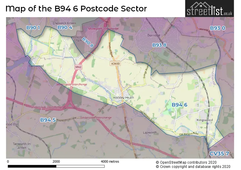
The B94 6 Postcode shares a border with B90 1 (Shirley, Tidbury Green), B90 8 (Shirley), B93 0 (Knowle, Chadwick End), B93 8 (Dorridge, Bentley Heath, Knowle), B94 5 (Earlswood, Tanworth-in-Arden, Lapworth), B90 4 (Shirley, Cheswick Green) and CV35 7 (Hatton Park, Hatton, Leek Wootton).
Map of the B94 6 Postcode Sector
Explore the B94 6 postcode sector by using our interactive map.
The sector is within the post town of SOLIHULL.
B94 6 is a postcode sector within the B94 postcode district which is within the B Birmingham postcode area.
The Royal Mail delivery office for the B94 6 postal sector is the Knowle Delivery Office.
The area of the B94 6 postcode sector is 7.24 square miles which is 18.74 square kilometres or 4,631.91 square acres.
The B94 6 postcode sector is crossed by the M42 motorway.
The B94 6 postcode sector is crossed by the M40 motorway.
Waterways within the B94 6 postcode sector include the Stratford-upon-Avon Canal, Grand Union Canal, Lapworth Link.
Your support helps keep this site running!
If you enjoy using this website, consider buying me a coffee to help cover hosting costs.


| B | 9 | 4 | - | 6 | X | X |
| B | 9 | 4 | Space | 6 | Letter | Letter |
Official List of Streets
Hockley Heath (35 Streets)
Lapworth (21 Streets)
Earlswood (12 Streets)
Unofficial Streets or Alternative Spellings
Lapworth
BROME HALL LANE CATESBY LANE CHURCH LANE WHARF LANEKnowle
RISING LANE AVENUE ALBERT DACE GROVE DARBY CLOSE DRAWBRIDGE GALTON CLOSE GILLIOT DRIVE GILLOTT DRIVE HOCKLEY HEATH DIRT TRACK MALT HOUSE BARNS PACKWOOD AVENUE ROEBUCK DRIVE SADDLERS WELL LANE THE COMMON VENDACE ROAD WALLIS CLOSEHockley Heath
NUTHURST LANE TITHE BARN LANEDorridge
BOX TREES ROAD GATE LANE GRANGE ROAD WINDMILL LANEShirley
HUDSON CLOSE JOHN WYATT CLOSE TANWORTH LANE WHITTLE DRIVE WHITTLE ROADEarlswood
EARLSWOOD COMMON MALTHOUSE LANE NORTON LANE WOOD LANEHall Green
STRATFORD ROADWeather Forecast for B94 6
Weather Forecast for Packwood House
| Time Period | Icon | Description | Temperature | Rain Probability | Wind |
|---|---|---|---|---|---|
| 03:00 to 06:00 | Overcast | 4.0°C (feels like 2.0°C) | 10.00% | SSW 7 mph | |
| 06:00 to 09:00 | Overcast | 5.0°C (feels like 2.0°C) | 16.00% | SSW 7 mph | |
| 09:00 to 12:00 | Overcast | 5.0°C (feels like 3.0°C) | 17.00% | SSW 7 mph | |
| 12:00 to 15:00 | Cloudy | 8.0°C (feels like 5.0°C) | 6.00% | SSW 11 mph | |
| 15:00 to 18:00 | Cloudy | 9.0°C (feels like 6.0°C) | 6.00% | SSW 11 mph | |
| 18:00 to 21:00 | Cloudy | 6.0°C (feels like 4.0°C) | 6.00% | S 9 mph | |
| 21:00 to 00:00 | Cloudy | 6.0°C (feels like 3.0°C) | 5.00% | SSW 11 mph |
| Time Period | Icon | Description | Temperature | Rain Probability | Wind |
|---|---|---|---|---|---|
| 00:00 to 03:00 | Cloudy | 6.0°C (feels like 2.0°C) | 6.00% | SSW 11 mph | |
| 03:00 to 06:00 | Cloudy | 6.0°C (feels like 2.0°C) | 5.00% | SSW 13 mph | |
| 06:00 to 09:00 | Cloudy | 7.0°C (feels like 3.0°C) | 5.00% | SSW 13 mph | |
| 09:00 to 12:00 | Cloudy | 8.0°C (feels like 4.0°C) | 7.00% | SSW 13 mph | |
| 12:00 to 15:00 | Cloudy | 10.0°C (feels like 6.0°C) | 19.00% | SSW 16 mph | |
| 15:00 to 18:00 | Light rain | 10.0°C (feels like 7.0°C) | 66.00% | SSW 13 mph | |
| 18:00 to 21:00 | Heavy rain | 8.0°C (feels like 6.0°C) | 75.00% | SW 11 mph | |
| 21:00 to 00:00 | Clear night | 6.0°C (feels like 3.0°C) | 5.00% | WSW 11 mph |
| Time Period | Icon | Description | Temperature | Rain Probability | Wind |
|---|---|---|---|---|---|
| 00:00 to 03:00 | Clear night | 5.0°C (feels like 2.0°C) | 1.00% | WSW 9 mph | |
| 03:00 to 06:00 | Clear night | 4.0°C (feels like 0.0°C) | 1.00% | WSW 9 mph | |
| 06:00 to 09:00 | Clear night | 3.0°C (feels like 0.0°C) | 1.00% | WSW 7 mph | |
| 09:00 to 12:00 | Cloudy | 3.0°C (feels like 0.0°C) | 4.00% | WSW 7 mph | |
| 12:00 to 15:00 | Cloudy | 6.0°C (feels like 4.0°C) | 4.00% | W 7 mph | |
| 15:00 to 18:00 | Cloudy | 7.0°C (feels like 6.0°C) | 4.00% | WNW 7 mph | |
| 18:00 to 21:00 | Partly cloudy (night) | 4.0°C (feels like 3.0°C) | 1.00% | WNW 4 mph | |
| 21:00 to 00:00 | Clear night | 3.0°C (feels like 1.0°C) | 1.00% | NNW 2 mph |
| Time Period | Icon | Description | Temperature | Rain Probability | Wind |
|---|---|---|---|---|---|
| 00:00 to 03:00 | Clear night | 1.0°C (feels like -1.0°C) | 1.00% | NNW 2 mph | |
| 03:00 to 06:00 | Clear night | 0.0°C (feels like -2.0°C) | 2.00% | NNW 4 mph | |
| 06:00 to 09:00 | Clear night | 0.0°C (feels like -2.0°C) | 3.00% | NNE 4 mph | |
| 09:00 to 12:00 | Sunny day | 1.0°C (feels like -1.0°C) | 2.00% | NNE 4 mph | |
| 12:00 to 15:00 | Sunny day | 5.0°C (feels like 3.0°C) | 1.00% | ENE 4 mph | |
| 15:00 to 18:00 | Sunny day | 7.0°C (feels like 5.0°C) | 1.00% | ENE 7 mph | |
| 18:00 to 21:00 | Clear night | 4.0°C (feels like 2.0°C) | 1.00% | ENE 7 mph | |
| 21:00 to 00:00 | Clear night | 3.0°C (feels like 0.0°C) | 1.00% | ENE 7 mph |
Schools and Places of Education Within the B94 6 Postcode Sector
Lapworth CofE Primary School
Voluntary controlled school
Station Lane, Solihull, Warwickshire, B94 6LT
Head: Mrs Judy McCluskey
Ofsted Rating: Good
Inspection: 2020-02-26 (1804 days ago)
Website: Visit Lapworth CofE Primary School Website
Phone: 01564783225
Number of Pupils: 170
St Patricks Church of England Primary Academy
Academy converter
Salter Street, Solihull, West Midlands, B94 6DE
Head: Caroline Glennon
Ofsted Rating: Good
Inspection: 2023-12-06 (425 days ago)
Website: Visit St Patricks Church of England Primary Academy Website
Phone: 01564702278
Number of Pupils: 246
Tudor Grange Primary Academy Hockley Heath
Academy converter
School Road, Solihull, West Midlands, B94 6RA
Head: Miss Louise Porter
Ofsted Rating: Good
Inspection: 2018-12-18 (2239 days ago)
Website: Visit Tudor Grange Primary Academy Hockley Heath Website
Phone: 01564783161
Number of Pupils: 220
House Prices in the B94 6 Postcode Sector
| Type of Property | 2018 Average | 2018 Sales | 2017 Average | 2017 Sales | 2016 Average | 2016 Sales | 2015 Average | 2015 Sales |
|---|---|---|---|---|---|---|---|---|
| Detached | £899,854 | 38 | £602,535 | 31 | £636,788 | 26 | £658,170 | 32 |
| Semi-Detached | £378,500 | 17 | £369,894 | 26 | £327,926 | 21 | £354,103 | 17 |
| Terraced | £313,090 | 5 | £342,883 | 9 | £291,329 | 12 | £267,194 | 12 |
| Flats | £344,250 | 4 | £238,125 | 4 | £265,000 | 4 | £241,825 | 6 |
Important Postcodes B94 6 in the Postcode Sector
B94 6DE is the postcode for St Patricks C of E Primary School Academy, Salter Street, Earlswood, St Patrick's C of E Primary School Academy, Salter Street, and St. Patricks C of E Junior & Infant School, Salter Street
B94 6RA is the postcode for Hockley Heath Primary School, School Road, Hockley Heath, and Hockley Heath Academy, School Road
| The B94 6 Sector is within these Local Authorities |
|
|---|---|
| The B94 6 Sector is within these Counties |
|
| The B94 6 Sector is within these Water Company Areas |
|
Tourist Attractions within the B94 6 Postcode Area
We found 1 visitor attractions within the B94 postcode area
| Packwood House |
|---|
| Historic Properties |
| Historic House / House and Garden / Palace |
| View Packwood House on Google Maps |