
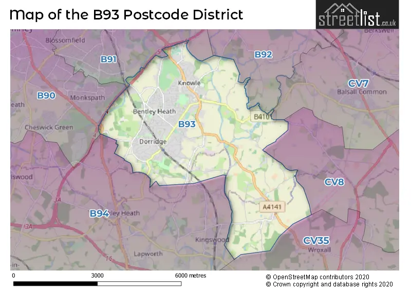
Map of the B93 Postcode District
Explore the postcode district by using our interactive map.
Circles represent recorded crime; the larger the circle, the higher the crime rates.
Your support helps keep this site running!
If you enjoy using this website, consider buying me a coffee to help cover hosting costs.
Where is the B93 District?
To give you an idea where the district is located we have created the following table showing nearby towns.
Nearest Towns to B93
| Town | Distance (miles) | Direction |
|---|---|---|
| Solihull | 3.36 | NW |
| Henley-in-Arden | 6.07 | SSW |
| Kenilworth | 6.72 | ESE |
| Coleshill | 8.58 | N |
| Warwick | 8.63 | SE |
| Coventry | 9.69 | ENE |
| Royal Leamington Spa | 9.97 | SE |
| Redditch | 10.12 | WSW |
| Birmingham | 10.33 | NW |
| Whitnash | 11.20 | SE |
| Stratford-upon-Avon | 12.58 | S |
| Alcester | 12.62 | SSW |
| Smethwick | 12.91 | NW |
| Bedworth | 13.06 | ENE |
| Royal Sutton Coldfield | 13.65 | NNW |
| Bromsgrove | 14.23 | W |
| Blackheath | 14.94 | WNW |
| Halesowen | 15.05 | WNW |
| Nuneaton | 15.06 | NE |
| Oldbury | 15.12 | NW |
The post town for this district is SOLIHULL.
Postcode Information for District B93 (Total Geographical Postcodes: 594)
| Location | Post Town | Sector | Number of Postcodes |
|---|---|---|---|
| Knowle | SOLIHULL | B93 9 | 176 |
| Dorridge | SOLIHULL | B93 8 | 172 |
| Knowle | SOLIHULL | B93 0 | 125 |
| Bentley Heath | SOLIHULL | B93 8 | 46 |
| Chadwick End | SOLIHULL | B93 0 | 38 |
| Bentley Heath | SOLIHULL | B93 9 | 22 |
| Knowle | SOLIHULL | B93 8 | 15 |
Retail and Shopping in B93
Street
Town
Locality
Number of Shops
Central Postcode
View on Google Maps
HIGH STREET
SOLIHULL
KNOWLE
67
B93 0JU
View on Google Maps
STATION ROAD
SOLIHULL
KNOWLE
23
B93 0HT
View on Google Maps
STATION ROAD
SOLIHULL
DORRIDGE
22
B93 8HH
View on Google Maps
ST JOHNS WAY
SOLIHULL
KNOWLE
15
B93 0LE
View on Google Maps
STATION APPROACH
SOLIHULL
DORRIDGE
9
B93 8JA
View on Google Maps
WIDNEY ROAD
SOLIHULL
KNOWLE
8
B93 9BN
View on Google Maps
| Street | Town | Locality | Number of Shops | Central Postcode | View on Google Maps |
|---|---|---|---|---|---|
| HIGH STREET | SOLIHULL | KNOWLE | 67 | B93 0JU | View on Google Maps |
| STATION ROAD | SOLIHULL | KNOWLE | 23 | B93 0HT | View on Google Maps |
| STATION ROAD | SOLIHULL | DORRIDGE | 22 | B93 8HH | View on Google Maps |
| ST JOHNS WAY | SOLIHULL | KNOWLE | 15 | B93 0LE | View on Google Maps |
| STATION APPROACH | SOLIHULL | DORRIDGE | 9 | B93 8JA | View on Google Maps |
| WIDNEY ROAD | SOLIHULL | KNOWLE | 8 | B93 9BN | View on Google Maps |
Based on the data provided for the B93 postcode district, the primary settlement is Chadwick End in Solihull, Warwickshire. Other significant settlements in the B93 district include Knowle and Bentley Heath, both also in Solihull, West Midlands. The county associated with the B93 postcode district is Warwickshire. The most significant post town in the B93 district is Solihull.
When it comes to local government, postal geography often disregards political borders. However, this district intersects the following councils: the district mostly encompasses the Solihull District (B) (500 postal codes), and finally, the Warwick District area (17 postal codes).
The largest settlement in the B93 postal code is Knowle followed by Dorridge, and Bentley Heath.
The B93 Postcode shares a border with B91 (SOLIHULL, Catherine-de-Barnes), B92 (SOLIHULL, Hampton-in-Arden, Barston), CV7 (Balsall Common, Exhall, Meriden), B94 (Hockley Heath, Lapworth, Earlswood), B90 (Shirley, Cheswick Green, Tidbury Green) and CV8 (KENILWORTH, Wolston, Ryton On Dunsmore).


Dentists in the B93 District
| # | Name | Address | Type | Contact |
|---|---|---|---|---|
| 1 | Dental Surgery | 76 WIDNEY ROAD , BENTLEY HEATH , SOLIHULL , WEST MIDLANDS , B93 9AW | GENERAL DENTAL PRACTICE | |
| 2 | Dental Surgery | 4 WILSONS ROAD , KNOWLE , SOLIHULL , WEST MIDLANDS , B93 0HZ | GENERAL DENTAL PRACTICE | |
| 3 | Dental Surgery | 474 STATION ROAD , DORRIDGE , SOLIHULL , WEST MIDLANDS , B93 8HE | GENERAL DENTAL PRACTICE | |
| 4 | Dental Surgery | 1473B WARWICK ROAD , KNOWLE , SOLIHULL , WEST MIDLANDS , B93 9LU | GENERAL DENTAL PRACTICE | |
| 5 | The Dental Practice | 1 DOWNING CLOSE , KNOWLE , SOLIHULL , WEST MIDLANDS , B93 0QA | GENERAL DENTAL PRACTICE | |
| 6 | Same Day Teeth West Midlands Ltd | 51 STATION ROAD , KNOWLE , SOLIHULL , WEST MIDLANDS , B93 0HN | GENERAL DENTAL PRACTICE | |
| 7 | Ascent Dental Care Solihull | 1 ARDEN BUILDINGS , STATION ROAD , DORRIDGE , SOLIHULL , B93 8HH | GENERAL DENTAL PRACTICE |
Doctors in the B93 District
| # | Name | Address | Type | Contact |
|---|---|---|---|---|
| 1 | Dorridge Surgery | , 3 AVENUE ROAD , DORRIDGE , SOLIHULL , WEST MIDLANDS , B93 8LH | GP PRACTICE | |
| 2 | Arden Medical Centre | , STATION ROAD, KNOWLE , SOLIHULL , WEST MIDLANDS , B93 0QA | GP PRACTICE | |
| 3 | The Blythe Practice | , KNOWLE , SOLIHULL , WEST MIDLANDS , B93 9LE | BRANCH SURGERY | |
| 4 | Gps Healthcare, Knowle Surgery - Covid Local Vaccination Service | , 1500 WARWICK ROAD , KNOWLE , SOLIHULL , B93 9LE | BRANCH SURGERY |
Chemists in the B93 District
| # | Name | Address | Type | Contact |
|---|---|---|---|---|
| 1 | Dorridge Pharmacy | UNIT 5 FOREST COURT , DORRIDGE , SOLIHULL , WEST MIDLANDS , B93 8JA | PHARMACY | |
| 2 | Windridge Pharmacy | 1709 HIGH STREET , KNOWLE , SOLIHULL , WEST MIDLANDS , B93 0LN | PHARMACY |
Opticians in the B93 District
| # | Name | Address | Type | Contact |
|---|---|---|---|---|
| 1 | VISION EXPRESS (SOLIHULL) | 1642 HIGH STREET , KNOWLE , SOLIHULL , WEST MIDLANDS , B93 0NA | OPTICAL SITE | |
| 2 | ALAN TYLER OPTICIANS (DORRIDGE) | 11 ARDEN BUILDINGS , STATION ROAD , DORRIDGE , SOLIHULL , WEST MIDLANDS , B93 8HH | OPTICAL SITE | |
| 3 | BANNISTER OPTICIANS LTD | 17 ST. JOHNS WAY , KNOWLE , SOLIHULL , WEST MIDLANDS , B93 0LE | OPTICAL SITE | |
| 4 | BANNISTER EYECARE | 17 ST. JOHNS WAY , KNOWLE , SOLIHULL , B93 0LE | OPTICAL SITE |
Schools in the Sector
Springfield House Community Special School
Phase: Not applicable
Address: Kenilworth Road , Knowle , Solihull
Postcode: B93 0AJ
Headteacher: Mr Paul Yeomans (Headteacher)
Ofsted Rating: Good
Lady Katherine Leveson Church of England Primary School
Phase: Primary
Address: Fen End Road West , Temple Balsall , Knowle , Solihull
Postcode: B93 0AN
Headteacher: Mr Simon Russell ()
Ofsted Rating: Requires improvement
Lady Katherine Leveson Church of England Primary School
Phase: Primary
Address: Fen End Road West , Temple Balsall , Knowle , Solihull
Postcode: B93 0AN
Headteacher: Mr Neil Kitching ()
Ofsted Rating: Good
Knowle Church of England Primary School
Phase: Primary
Address: Kixley Lane , Knowle , Solihull
Postcode: B93 0JE
Headteacher: Miss Jenny Godsall (Acting Headteacher)
Ofsted Rating: Outstanding
Knowle Church of England Primary Academy
Phase: Primary
Address: Kixley Lane , Knowle , Solihull
Postcode: B93 0JE
Headteacher: Mr Matthew Stonehill (Principal)
Ofsted Rating: Good
Arden School
Phase: Secondary
Address: Station Road , Knowle , Solihull
Postcode: B93 0PT
Headteacher: Mrs Ann Green (Headteacher)
Ofsted Rating: Outstanding
Arden
Phase: Secondary
Address: Station Road , Knowle , Solihull
Postcode: B93 0PT
Headteacher: Mr David Warwood (Principal)
Ofsted Rating: Good
Dorridge Primary School
Phase: Primary
Address: Station Road , Dorridge , Solihull
Postcode: B93 8EU
Headteacher: Mrs Roslyn Ashe (Headteacher)
Ofsted Rating: Good
St George and St Teresa Catholic Primary School
Phase: Primary
Address: Mill Lane , Bentley Heath , Solihull
Postcode: B93 8PA
Headteacher: Mrs Nicola Wright (Headteacher)
Ofsted Rating: Good
St George and St Teresa Catholic Primary School
Phase: Primary
Address: Mill Lane , Bentley Heath , Solihull
Postcode: B93 8PA
Headteacher: Mrs Louise Flanagan (Headteacher)
Ofsted Rating: Requires improvement
Bentley Heath Church of England Primary School
Phase: Primary
Address: Widney Close , Bentley Heath , Solihull
Postcode: B93 9AS
Headteacher: Mrs Hannah Cook (Headteacher)
Ofsted Rating: Good
Stations in the Sector
Dorridge
CRS Code: DDG
Operator: CH
Line: Chiltern Main Line
Company: Chiltern Railway
Accessable Motorway Junctions
M42 J5
Average Driving Time from within the district: 4.24
Average Driving Distance: 2.20
Number of Postcodes that can access the Motorway Junction: 526
M42 J4
Average Driving Time from within the district: 4.76
Average Driving Distance: 2.82
Number of Postcodes that can access the Motorway Junction: 526
M42 J6
Average Driving Time from within the district: 7.37
Average Driving Distance: 5.44
Number of Postcodes that can access the Motorway Junction: 470
M40 J16
Average Driving Time from within the district: 7.58
Average Driving Distance: 4.74
Number of Postcodes that can access the Motorway Junction: 526
M42 J3
Average Driving Time from within the district: 8.31
Average Driving Distance: 7.03
Number of Postcodes that can access the Motorway Junction: 54
M40 J15
Average Driving Time from within the district: 14.86
Average Driving Distance: 9.60
Number of Postcodes that can access the Motorway Junction: 2
Weather Forecast for Knowle (West Midlands)
| Time Period | Icon | Description | Temperature | Rain Probability | Wind |
|---|---|---|---|---|---|
| 06:00 to 09:00 | Cloudy | 3.0°C (feels like 0.0°C) | 8.00% | S 9 mph | |
| 09:00 to 12:00 | Cloudy | 3.0°C (feels like -1.0°C) | 4.00% | S 9 mph | |
| 12:00 to 15:00 | Partly cloudy (day) | 5.0°C (feels like 2.0°C) | 1.00% | S 9 mph | |
| 15:00 to 18:00 | Partly cloudy (day) | 6.0°C (feels like 4.0°C) | 1.00% | SSW 9 mph | |
| 18:00 to 21:00 | Cloudy | 4.0°C (feels like 2.0°C) | 4.00% | SSW 4 mph | |
| 21:00 to 00:00 | Cloudy | 4.0°C (feels like 1.0°C) | 4.00% | SSW 7 mph |
| Time Period | Icon | Description | Temperature | Rain Probability | Wind |
|---|---|---|---|---|---|
| 00:00 to 03:00 | Overcast | 4.0°C (feels like 1.0°C) | 7.00% | SSW 7 mph | |
| 03:00 to 06:00 | Overcast | 4.0°C (feels like 1.0°C) | 9.00% | SSW 7 mph | |
| 06:00 to 09:00 | Overcast | 4.0°C (feels like 1.0°C) | 9.00% | SSW 7 mph | |
| 09:00 to 12:00 | Overcast | 4.0°C (feels like 1.0°C) | 8.00% | SSW 9 mph | |
| 12:00 to 15:00 | Cloudy | 7.0°C (feels like 4.0°C) | 6.00% | SSW 9 mph | |
| 15:00 to 18:00 | Cloudy | 8.0°C (feels like 6.0°C) | 5.00% | SSW 9 mph | |
| 18:00 to 21:00 | Overcast | 7.0°C (feels like 4.0°C) | 7.00% | S 9 mph | |
| 21:00 to 00:00 | Overcast | 6.0°C (feels like 3.0°C) | 7.00% | SSW 11 mph |
| Time Period | Icon | Description | Temperature | Rain Probability | Wind |
|---|---|---|---|---|---|
| 00:00 to 03:00 | Overcast | 6.0°C (feels like 3.0°C) | 8.00% | SSW 11 mph | |
| 03:00 to 06:00 | Overcast | 6.0°C (feels like 3.0°C) | 8.00% | SSW 13 mph | |
| 06:00 to 09:00 | Overcast | 6.0°C (feels like 3.0°C) | 9.00% | SSW 13 mph | |
| 09:00 to 12:00 | Cloudy | 7.0°C (feels like 3.0°C) | 8.00% | SSW 13 mph | |
| 12:00 to 15:00 | Overcast | 9.0°C (feels like 6.0°C) | 18.00% | SSW 13 mph | |
| 15:00 to 18:00 | Light rain | 10.0°C (feels like 7.0°C) | 55.00% | SSW 13 mph | |
| 18:00 to 21:00 | Light rain shower (night) | 8.0°C (feels like 6.0°C) | 39.00% | SW 9 mph | |
| 21:00 to 00:00 | Clear night | 7.0°C (feels like 4.0°C) | 8.00% | WSW 9 mph |
| Time Period | Icon | Description | Temperature | Rain Probability | Wind |
|---|---|---|---|---|---|
| 00:00 to 03:00 | Clear night | 5.0°C (feels like 2.0°C) | 3.00% | WSW 9 mph | |
| 03:00 to 06:00 | Clear night | 4.0°C (feels like 1.0°C) | 1.00% | W 7 mph | |
| 06:00 to 09:00 | Clear night | 2.0°C (feels like 0.0°C) | 1.00% | W 7 mph | |
| 09:00 to 12:00 | Cloudy | 3.0°C (feels like 1.0°C) | 4.00% | W 4 mph | |
| 12:00 to 15:00 | Cloudy | 6.0°C (feels like 4.0°C) | 4.00% | WNW 4 mph | |
| 15:00 to 18:00 | Cloudy | 7.0°C (feels like 6.0°C) | 4.00% | WNW 4 mph | |
| 18:00 to 21:00 | Partly cloudy (night) | 4.0°C (feels like 3.0°C) | 1.00% | SW 2 mph | |
| 21:00 to 00:00 | Clear night | 3.0°C (feels like 1.0°C) | 1.00% | SE 4 mph |
| Postal Sector | Delivery Office |
|---|---|
| B93 0 | Knowle Delivery Office |
| B93 8 | Knowle Delivery Office |
| B93 9 | Knowle Delivery Office |
| B | 9 | 3 | - | X | X | X |
| B | 9 | 3 | Space | Numeric | Letter | Letter |
Tourist Attractions
We found 1 visitor attractions.
| Baddesley Clinton |
|---|
| Historic Properties |
| Historic House / House and Garden / Palace |
| View Baddesley Clinton on Google Maps |
Street List for the B93 District
Current Monthly Rental Prices
| # Bedrooms | Min Price | Max Price | Avg Price |
|---|---|---|---|
| 1 | £762 | £775 | £769 |
| 2 | £950 | £1,950 | £1,298 |
| 3 | £1,750 | £2,300 | £2,025 |
| 4 | £2,195 | £3,200 | £2,548 |
| 5 | £3,995 | £3,995 | £3,995 |
| 6 | £3,950 | £3,950 | £3,950 |
Current House Prices
| # Bedrooms | Min Price | Max Price | Avg Price |
|---|---|---|---|
| 3 | £995,950 | £1,200,000 | £1,097,975 |
| 4 | £900,000 | £1,750,000 | £1,119,500 |
| 5 | £895,000 | £2,500,000 | £1,654,375 |
| 6 | £1,000,000 | £2,000,000 | £1,498,333 |
| 7 | £1,650,000 | £1,900,000 | £1,775,000 |
Estate Agents
| Logo | Name | Brand Name | Address | Contact Number |
|---|---|---|---|---|
 | Knowle | Xact Homes | 1632-1634, High Street, Knowle, Solihull, B93 0JU | 01564 334705 |
 | Dorridge | DM & Co. Homes | 2 Forest Court Shopping Centre, Solihull, B93 8FG | 0121 387 6788 |
 | Bournemouth | McCarthy & Stone Resales | 100 Holdenhurst Road, Bournemouth, BH8 8AQ | 03455 564122 |
 | Knowle | EB&P | EB&P Limited 124 Station Road Knowle Solihull B93 0EP | 01564 331105 |
 | Knowle | Hunters | 1626 High Street Knowle B93 0JU | 01564 335024 |
Yearly House Price Averages for the District
| Type of Property | 2018 Average | 2018 Sales | 2017 Average | 2017 Sales | 2016 Average | 2016 Sales | 2015 Average | 2015 Sales |
|---|---|---|---|---|---|---|---|---|
| Detached | £682,187 | 186 | £673,448 | 161 | £604,232 | 163 | £564,157 | 230 |
| Semi-Detached | £406,458 | 88 | £372,998 | 81 | £369,544 | 89 | £400,771 | 91 |
| Terraced | £372,606 | 46 | £383,144 | 72 | £328,117 | 50 | £301,533 | 52 |
| Flats | £287,325 | 38 | £261,046 | 56 | £271,298 | 76 | £241,084 | 126 |