
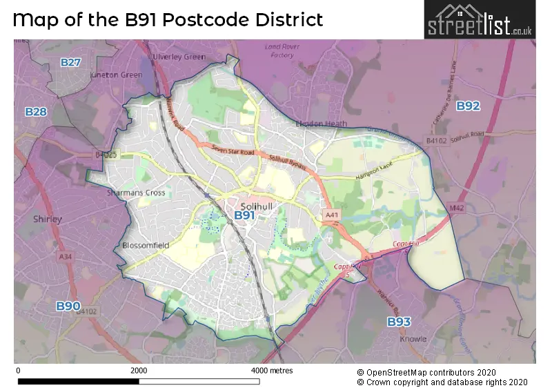
Map of the B91 Postcode District
Explore the postcode district by using our interactive map.
Circles represent recorded crime; the larger the circle, the higher the crime rates.
Your support helps keep this site running!
If you enjoy using this website, consider buying me a coffee to help cover hosting costs.
Where is the B91 District?
To give you an idea where the district is located we have created the following table showing nearby towns.
Nearest Towns to B91
| Town | Distance (miles) | Direction |
|---|---|---|
| Coleshill | 6.52 | NNE |
| Birmingham | 7.08 | NW |
| Henley-in-Arden | 8.38 | S |
| Kenilworth | 9.63 | ESE |
| Smethwick | 9.75 | WNW |
| Redditch | 10.17 | SW |
| Royal Sutton Coldfield | 10.57 | N |
| Coventry | 11.35 | E |
| Warwick | 11.93 | SE |
| West Bromwich | 11.93 | NW |
| Oldbury | 11.99 | WNW |
| Blackheath | 12.05 | WNW |
| Halesowen | 12.39 | WNW |
| Rowley Regis | 12.42 | WNW |
| Royal Leamington Spa | 13.15 | SE |
| Bromsgrove | 13.17 | WSW |
| Bedworth | 13.59 | ENE |
| Wednesbury | 14.07 | NW |
| Tipton | 14.26 | NW |
The post town for this district is SOLIHULL.
Postcode Information for District B91 (Total Geographical Postcodes: 771)
| Location | Post Town | Sector | Number of Postcodes |
|---|---|---|---|
| SOLIHULL | SOLIHULL | B91 3 | 285 |
| SOLIHULL | SOLIHULL | B91 1 | 248 |
| SOLIHULL | SOLIHULL | B91 2 | 225 |
| Catherine-de-Barnes | SOLIHULL | B91 2 | 13 |
Retail and Shopping in B91
Street
Town
Locality
Number of Shops
Central Postcode
View on Google Maps
TOUCHWOOD
SOLIHULL
85
B91 3GZ
View on Google Maps
HIGH STREET
SOLIHULL
63
B91 3TA
View on Google Maps
DRURY LANE
SOLIHULL
36
B91 3BG
View on Google Maps
MILL LANE
SOLIHULL
36
B91 3AR
View on Google Maps
STATION ROAD
SOLIHULL
33
B91 3SB
View on Google Maps
WARWICK ROAD
SOLIHULL
33
B91 1BQ
View on Google Maps
MELL SQUARE
SOLIHULL
13
B91 3AY
View on Google Maps
POPLAR WAY
SOLIHULL
10
B91 3BX
View on Google Maps
DAMSON LANE
SOLIHULL
7
B91 2RE
View on Google Maps
POPLAR ROAD
SOLIHULL
6
B91 3AB
View on Google Maps
| Street | Town | Locality | Number of Shops | Central Postcode | View on Google Maps |
|---|---|---|---|---|---|
| TOUCHWOOD | SOLIHULL | 85 | B91 3GZ | View on Google Maps | |
| HIGH STREET | SOLIHULL | 63 | B91 3TA | View on Google Maps | |
| DRURY LANE | SOLIHULL | 36 | B91 3BG | View on Google Maps | |
| MILL LANE | SOLIHULL | 36 | B91 3AR | View on Google Maps | |
| STATION ROAD | SOLIHULL | 33 | B91 3SB | View on Google Maps | |
| WARWICK ROAD | SOLIHULL | 33 | B91 1BQ | View on Google Maps | |
| MELL SQUARE | SOLIHULL | 13 | B91 3AY | View on Google Maps | |
| POPLAR WAY | SOLIHULL | 10 | B91 3BX | View on Google Maps | |
| DAMSON LANE | SOLIHULL | 7 | B91 2RE | View on Google Maps | |
| POPLAR ROAD | SOLIHULL | 6 | B91 3AB | View on Google Maps |
The primary settlement in the B91 postcode district is Solihull, located in the West Midlands. Solihull has the highest count of postcodes within this district. Additionally, there is another significant settlement called Catherine-de-Barnes, also located in Solihull. The county in which these settlements are located is the West Midlands county. The most significant post town in the B91 postcode district is Solihull.
When it comes to local government, postal geography often disregards political borders. However, this district intersects the following councils: the district mostly encompasses the Solihull District (B) area with a total of 852 postal codes.
The largest settlements in the B91 postal code are SOLIHULL and Catherine-de-Barnes.
The B91 Postcode shares a border with B92 (SOLIHULL, Hampton-in-Arden, Barston), B93 (Knowle, Dorridge, Bentley Heath) and B90 (Shirley, Cheswick Green, Tidbury Green).


Dentists in the B91 District
| # | Name | Address | Type | Contact |
|---|---|---|---|---|
| 1 | Solihull Dental Clinic | 51 GROVE ROAD , SOLIHULL , WEST MIDLANDS , B91 2AQ | GENERAL DENTAL PRACTICE | |
| 2 | Eternal Smiles | 18 STATION ROAD , SOLIHULL , B91 3SB | GENERAL DENTAL PRACTICE | |
| 3 | Mr A Coley-smith | 85 SHARMANS CROSS ROAD , SOLIHULL , WEST MIDLANDS , B91 1PH | GENERAL DENTAL PRACTICE | |
| 4 | Dental Surgery | 345 WARWICK ROAD , SOLIHULL , WEST MIDLANDS , B91 1BQ | GENERAL DENTAL PRACTICE | |
| 5 | Ground Floor Netherwood Building | SOLIHULL HOSPITAL , LODE LANE , SOLIHULL , WEST MIDLANDS , B91 2JL | GENERAL DENTAL PRACTICE | |
| 6 | Dental Surgery | DOUBLE DAY HOUSE , 29 HIGH STREET , SOLIHULL , WEST MIDLANDS , B91 3SJ | GENERAL DENTAL PRACTICE | |
| 7 | Dental Surgery | 532 STREETSBROOK ROAD , SOLIHULL , WEST MIDLANDS , B91 1RD | GENERAL DENTAL PRACTICE | |
| 8 | Dental Surgery | 606 WARWICK ROAD , SOLIHULL , WEST MIDLANDS , B91 1AA | GENERAL DENTAL PRACTICE | |
| 9 | Blossomfield House | 284 286 BLOSSOMFIELD ROAD , SOLIHULL , WEST MIDLANDS , B91 1TH | GENERAL DENTAL PRACTICE | |
| 10 | Dental Practice Manor Square | 4-6 MANOR SQUARE , SOLIHULL , B91 3PX | GENERAL DENTAL PRACTICE | |
| 11 | Solihull Dental Practice | 391 WARWICK ROAD , SOLIHULL , B91 1BJ | GENERAL DENTAL PRACTICE | |
| 12 | Smile Concepts Limited | 91 LODE LANE , SOLIHULL , B91 2HH | GENERAL DENTAL PRACTICE |
Doctors in the B91 District
| # | Name | Address | Type | Contact |
|---|---|---|---|---|
| 1 | Solihull Healthcare Partnership | , 3 GROVE ROAD , SOLIHULL , WEST MIDLANDS , B91 2AG | GP PRACTICE | |
| 2 | Yew Tree Medical Centre | , SOLIHULL , WEST MIDLANDS , B91 2RA | BRANCH SURGERY | |
| 3 | Blossomfield Surgery | , SOLIHULL , B91 1TF | BRANCH SURGERY |
Chemists in the B91 District
| # | Name | Address | Type | Contact |
|---|---|---|---|---|
| 1 | Boots | 7 MELL SQUARE , SOLIHULL , WEST MIDLANDS , B91 3AZ | PHARMACY | |
| 2 | Superdrug Pharmacy | 34 MILL LANE ARCADE , TOUCHWOOD , SOLIHULL , WEST MIDLANDS , B91 3GS | PHARMACY | |
| 3 | Browns Pharmacy | 351 WARWICK ROAD , SOLIHULL , WEST MIDLANDS , B91 1BQ | PHARMACY | |
| 4 | Morrisons Pharmacy | GEORGE ROAD , SOLIHULL , B91 3BQ | PHARMACY | |
| 5 | Knights Pharmacy Solihull | 3 GROVE ROAD , SOLIHULL , WEST MIDLANDS , B91 2AG | PHARMACY | |
| 6 | Yew Tree Pharmacy | 57-59 YEW TREE LANE , SOLIHULL , B91 2NX | PHARMACY |
Opticians in the B91 District
| # | Name | Address | Type | Contact |
|---|---|---|---|---|
| 1 | SPECSAVERS (SOLIHULL) | 90 HIGH STREET , SOLIHULL , WEST MIDLANDS , B91 3TA | OPTICAL SITE | |
| 2 | WALFORD & ROUND OPTICIANS (SOLIHULL) | DOVEHOUSE PARADE , 363 WARWICK ROAD , SOLIHULL , WEST MIDLANDS , B91 1BQ | OPTICAL SITE | |
| 3 | PERSPECTIVE OPTICIANS LTD | 56 DRURY LANE , MELL SQUARE , SOLIHULL , WEST MIDLANDS , B91 3BH | OPTICAL SITE | |
| 4 | VISION EXPRESS (SOLIHULL) | 77 - 79 HIGH STREET , SOLIHULL , B91 3SW | OPTICAL SITE | |
| 5 | BOOTS OPTICIANS (SOLIHULL) | 57 MILL LANE , SOLIHULL , WEST MIDLANDS , B91 3AT | OPTICAL SITE | |
| 6 | OPTICAL EXPRESS (SOLIHULL) | DOMINION COURT , 43 STATION ROAD , SOLIHULL , WEST MIDLANDS , B91 3RT | OPTICAL SITE | |
| 7 | EYECARE AT HOME | 431A STREETSBROOK ROAD , SOLIHULL , WEST MIDLANDS , B91 1RE | OPTICAL SITE | |
| 8 | HESSA OPTICIANS (GRANGE ROAD) | 105 GRANGE ROAD , SOLIHULL , WEST MIDLANDS , B91 1BZ | OPTICAL SITE | |
| 9 | A B OPTICS LIMITED (WARWICK ROAD) | 681A WARWICK ROAD , SOLIHULL , WEST MIDLANDS , B91 3DA | OPTICAL SITE | |
| 10 | MIDLAND EYE | 50 LODE LANE , SOLIHULL , B91 2AW | OPTICAL SITE |
Schools in the Sector
Oak Cottage Primary School
Phase: Primary
Address: Greswolde Road , Solihull
Postcode: B91 1DY
Headteacher: Mr R Marshall (Headteacher)
Ofsted Rating: Outstanding
Sharmans Cross Junior School
Phase: Primary
Address: Sharmans Cross Road , Solihull
Postcode: B91 1PH
Headteacher: Miss Sara Wilkes (Headteacher)
Ofsted Rating: Good
Solihull College & University Centre
Phase: 16 plus
Address: Blossomfield Campus , Blossomfield Road , Solihull
Postcode: B91 1SB
Headteacher: Doctor Rebecca Gater (Principal & Chief Executive)
Ofsted Rating: Good
Alderbrook School
Phase: Secondary
Address: Blossomfield Road , Solihull
Postcode: B91 1SN
Headteacher: Thomas Beveridge (Headteacher)
Ofsted Rating: Good
Greswold Primary School
Phase: Primary
Address: Buryfield Road , Solihull
Postcode: B91 2AZ
Headteacher: Ms Karen Scott (Headteacher)
Ofsted Rating: Good
Triple Crown Centre
Phase: Not applicable
Address: Lode Lane , Solihull
Postcode: B91 2HW
Headteacher: Miss Eleanor Clarke (Head Teacher)
Ofsted Rating: Good
Lode Heath School
Phase: Secondary
Address: Lode Lane , Solihull
Postcode: B91 2HW
Headteacher: Ms Laura Suddon (Headteacher)
Ofsted Rating: Good
Yew Tree Primary School
Phase: Primary
Address: Wherretts Well Lane , Solihull
Postcode: B91 2SD
Headteacher: Mrs Rachael Russell (Headteacher)
Ofsted Rating: Good
St Alphege Church of England Infant and Nursery School
Phase: Primary
Address: New Road , Solihull
Postcode: B91 3DW
Headteacher: Mr Sam Smith (Executive Headteacher)
Ofsted Rating: Requires improvement
St Alphege Church of England Junior School
Phase: Primary
Address: Widney Manor Road , Solihull
Postcode: B91 3JG
Headteacher: Mr Sam Smith (Headteacher)
Ofsted Rating: Requires improvement
Widney Junior School
Phase: Primary
Address: Clifton Crescent , Solihull
Postcode: B91 3LQ
Headteacher: Mrs Joanna Bridges (Headteacher)
Ofsted Rating: Good
St Augustine's Catholic Primary School
Phase: Primary
Address: Whitefields Road , Solihull
Postcode: B91 3NZ
Headteacher: Mrs Julie Foley (Head Teacher)
Ofsted Rating: Good
St Peter's Catholic School
Phase: Secondary
Address: Whitefields Road , Solihull
Postcode: B91 3NZ
Headteacher: Mrs Marie Murphy (Headteacher)
Ofsted Rating: Outstanding
St Augustine's Catholic Primary School
Phase: Primary
Address: Whitefields Road , Solihull
Postcode: B91 3NZ
Headteacher: Mrs Julie Foley (Head Teacher)
Ofsted Rating: Good
Tudor Grange Academy, Solihull
Phase: Secondary
Address: Dingle Lane , Solihull
Postcode: B91 3PD
Headteacher: Mrs Claire Smith (Principal)
Ofsted Rating: Outstanding
Solihull Sixth Form College
Phase: 16 plus
Address: Widney Manor Road , Solihull
Postcode: B91 3WR
Headteacher: Dr Martin Sullivan ()
Ofsted Rating: Good
Stations in the Sector
Widney Manor
CRS Code: WMR
Operator: WM
Line: Chiltern Main Line
Company:
Solihull
CRS Code: SOL
Operator: CH
Line: Chiltern Main Line
Company: Chiltern Railway
Accessable Motorway Junctions
M42 J5
Average Driving Time from within the district: 4.11
Average Driving Distance: 2.17
Number of Postcodes that can access the Motorway Junction: 841
M42 J4
Average Driving Time from within the district: 5.70
Average Driving Distance: 3.75
Number of Postcodes that can access the Motorway Junction: 841
M42 J6
Average Driving Time from within the district: 7.14
Average Driving Distance: 5.29
Number of Postcodes that can access the Motorway Junction: 826
M42 J7
Average Driving Time from within the district: 8.63
Average Driving Distance: 7.19
Number of Postcodes that can access the Motorway Junction: 553
M40 J16
Average Driving Time from within the district: 9.37
Average Driving Distance: 6.58
Number of Postcodes that can access the Motorway Junction: 213
M6 J4
Average Driving Time from within the district: 10.13
Average Driving Distance: 8.44
Number of Postcodes that can access the Motorway Junction: 204
M42 J3
Average Driving Time from within the district: 11.69
Average Driving Distance: 5.70
Number of Postcodes that can access the Motorway Junction: 90
Weather Forecast for Solihull
| Time Period | Icon | Description | Temperature | Rain Probability | Wind |
|---|---|---|---|---|---|
| 00:00 to 03:00 | Overcast | 4.0°C (feels like 0.0°C) | 9.00% | SSE 11 mph | |
| 03:00 to 06:00 | Overcast | 4.0°C (feels like 0.0°C) | 9.00% | S 11 mph | |
| 06:00 to 09:00 | Cloudy | 3.0°C (feels like -1.0°C) | 8.00% | S 9 mph | |
| 09:00 to 12:00 | Cloudy | 3.0°C (feels like -1.0°C) | 5.00% | S 9 mph | |
| 12:00 to 15:00 | Partly cloudy (day) | 5.0°C (feels like 2.0°C) | 1.00% | S 9 mph | |
| 15:00 to 18:00 | Partly cloudy (day) | 6.0°C (feels like 3.0°C) | 2.00% | SSW 9 mph | |
| 18:00 to 21:00 | Cloudy | 4.0°C (feels like 2.0°C) | 5.00% | SSW 4 mph | |
| 21:00 to 00:00 | Cloudy | 4.0°C (feels like 1.0°C) | 4.00% | SSW 7 mph |
| Time Period | Icon | Description | Temperature | Rain Probability | Wind |
|---|---|---|---|---|---|
| 00:00 to 03:00 | Overcast | 4.0°C (feels like 1.0°C) | 7.00% | SSW 7 mph | |
| 03:00 to 06:00 | Overcast | 3.0°C (feels like 1.0°C) | 8.00% | SSW 7 mph | |
| 06:00 to 09:00 | Overcast | 4.0°C (feels like 1.0°C) | 9.00% | SSW 7 mph | |
| 09:00 to 12:00 | Overcast | 4.0°C (feels like 1.0°C) | 9.00% | SSW 9 mph | |
| 12:00 to 15:00 | Cloudy | 7.0°C (feels like 4.0°C) | 5.00% | SSW 9 mph | |
| 15:00 to 18:00 | Cloudy | 8.0°C (feels like 5.0°C) | 5.00% | SSW 9 mph | |
| 18:00 to 21:00 | Overcast | 7.0°C (feels like 4.0°C) | 7.00% | S 9 mph | |
| 21:00 to 00:00 | Overcast | 6.0°C (feels like 3.0°C) | 7.00% | SSW 11 mph |
| Time Period | Icon | Description | Temperature | Rain Probability | Wind |
|---|---|---|---|---|---|
| 00:00 to 03:00 | Overcast | 6.0°C (feels like 3.0°C) | 8.00% | SSW 11 mph | |
| 03:00 to 06:00 | Overcast | 6.0°C (feels like 3.0°C) | 8.00% | SSW 13 mph | |
| 06:00 to 09:00 | Overcast | 6.0°C (feels like 3.0°C) | 9.00% | SSW 13 mph | |
| 09:00 to 12:00 | Overcast | 7.0°C (feels like 3.0°C) | 10.00% | SSW 13 mph | |
| 12:00 to 15:00 | Overcast | 9.0°C (feels like 6.0°C) | 18.00% | SSW 13 mph | |
| 15:00 to 18:00 | Light rain | 9.0°C (feels like 7.0°C) | 55.00% | SSW 13 mph | |
| 18:00 to 21:00 | Light rain shower (night) | 8.0°C (feels like 6.0°C) | 40.00% | SW 9 mph | |
| 21:00 to 00:00 | Clear night | 7.0°C (feels like 4.0°C) | 8.00% | WSW 9 mph |
| Time Period | Icon | Description | Temperature | Rain Probability | Wind |
|---|---|---|---|---|---|
| 00:00 to 03:00 | Clear night | 5.0°C (feels like 2.0°C) | 3.00% | WSW 9 mph | |
| 03:00 to 06:00 | Clear night | 4.0°C (feels like 1.0°C) | 1.00% | W 7 mph | |
| 06:00 to 09:00 | Clear night | 2.0°C (feels like 0.0°C) | 1.00% | W 7 mph | |
| 09:00 to 12:00 | Cloudy | 3.0°C (feels like 1.0°C) | 4.00% | W 4 mph | |
| 12:00 to 15:00 | Cloudy | 6.0°C (feels like 4.0°C) | 4.00% | WNW 4 mph | |
| 15:00 to 18:00 | Cloudy | 7.0°C (feels like 6.0°C) | 4.00% | WNW 4 mph | |
| 18:00 to 21:00 | Partly cloudy (night) | 4.0°C (feels like 3.0°C) | 1.00% | SW 2 mph | |
| 21:00 to 00:00 | Clear night | 3.0°C (feels like 1.0°C) | 1.00% | SE 4 mph |
| Postal Sector | Delivery Office |
|---|---|
| B91 1 | Solihull Delivery Office |
| B91 2 | Solihull Delivery Office |
| B91 3 | Solihull Delivery Office |
| B | 9 | 1 | - | X | X | X |
| B | 9 | 1 | Space | Numeric | Letter | Letter |
Street List for the B91 District
Current Monthly Rental Prices
| # Bedrooms | Min Price | Max Price | Avg Price |
|---|---|---|---|
| 2 | £1,800 | £2,429 | £2,250 |
| 3 | £1,600 | £2,400 | £1,816 |
| 4 | £2,000 | £4,900 | £2,849 |
| 5 | £2,600 | £2,995 | £2,815 |
| 6 | £2,300 | £3,600 | £3,133 |
| 10 | £8,000 | £8,000 | £8,000 |
Current House Prices
| # Bedrooms | Min Price | Max Price | Avg Price |
|---|---|---|---|
| 4 | £989,000 | £1,350,000 | £1,105,667 |
| 5 | £1,000,000 | £1,950,000 | £1,411,154 |
| 6 | £1,350,000 | £2,500,000 | £1,890,000 |
| 10 | £2,700,000 | £2,700,000 | £2,700,000 |
Estate Agents
| Logo | Name | Brand Name | Address | Contact Number |
|---|---|---|---|---|
 | Solihull | Xact Homes | 6 The Square Solihull B91 3RB | 0121 387 6415 |
 | Solihull | Ruxton Independent Estate Agents & Valuers | 6 The Square, Solihull, B91 3RB | 0121 387 6388 |
 | Shirley | Smart Homes Ltd | 316 Stratford Road Shirley Solihull B90 3DN | 01202 145410 |
 | Solihull | DM & Co. Homes | 8 The Pavillions, Cranmore Drive, Solihull, B90 4SB | 0121 387 6730 |
 | Solihull | John Shepherd | 6-8, Drury Lane Solihull B91 3BD | 01202 145364 |
Yearly House Price Averages for the District
| Type of Property | 2018 Average | 2018 Sales | 2017 Average | 2017 Sales | 2016 Average | 2016 Sales | 2015 Average | 2015 Sales |
|---|---|---|---|---|---|---|---|---|
| Detached | £622,501 | 219 | £600,903 | 207 | £546,285 | 245 | £520,669 | 266 |
| Semi-Detached | £372,543 | 110 | £349,007 | 143 | £341,193 | 122 | £314,643 | 137 |
| Terraced | £295,813 | 35 | £287,376 | 53 | £249,647 | 55 | £252,819 | 55 |
| Flats | £238,959 | 221 | £231,056 | 207 | £204,787 | 171 | £215,767 | 198 |