A wide range of spatial data has been analysed to present this overview of the B8 1 Postcode sector. If you would like anything added, please contact us.
The B8 1 postcode sector is within the county of West Midlands.
Did you know? According to the 2021 Census, the B8 1 postcode sector is home to a bustling 11,953 residents!
Given that each sector allows for 400 unique postcode combinations. Letters C, I, K, M, O and V are not allowed in the last two letters of a postcode. With 168 postcodes already in use, this leaves 232 units available.
The largest settlement in the B8 1 postal code is BIRMINGHAM followed by Saltley, and Washwood Heath.
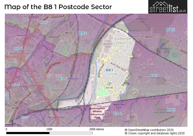
The B8 1 Postcode shares a border with B7 4 (BIRMINGHAM, Nechells), B9 4 (BIRMINGHAM, Bordesley, Bordesley Green), B7 5 (BIRMINGHAM, Nechells), B8 2 (BIRMINGHAM, Washwood Heath, Ward End) and B8 3 (BIRMINGHAM, Saltley, Alum Rock).
Map of the B8 1 Postcode Sector
Explore the B8 1 postcode sector by using our interactive map.
The sector is within the post town of BIRMINGHAM.
B8 1 is a postcode sector within the B8 postcode district which is within the B Birmingham postcode area.
The Royal Mail delivery office for the B8 1 postal sector is the Eastern (b) Delivery Office.
The area of the B8 1 postcode sector is 0.73 square miles which is 1.88 square kilometres or 465.70 square acres.
Waterways within the B8 1 postcode sector include the Warwick & Birmingham Junction Canal.
Your support helps keep this site running!
If you enjoy using this website, consider buying me a coffee to help cover hosting costs.


| B | 8 | - | 1 | X | X |
| B | 8 | Space | 1 | Letter | Letter |
Official List of Streets
BIRMINGHAM (50 Streets)
Saltley (17 Streets)
Washwood Heath (1 Streets)
Unofficial Streets or Alternative Spellings
Saltley
HIGHFIELD ROADWashwood Heath
WARREN ROADBIRMINGHAM
HARTS ROAD MIDLAND STREETNechells
ASTON CHURCH ROAD LIME TREE COTTAGES SALTLEY GATEAlum Rock
BRIDGE ROADWeather Forecast for B8 1
Weather Forecast for Saltley
| Time Period | Icon | Description | Temperature | Rain Probability | Wind |
|---|---|---|---|---|---|
| 21:00 to 00:00 | Cloudy | 6.0°C (feels like 3.0°C) | 4.00% | SSW 9 mph |
| Time Period | Icon | Description | Temperature | Rain Probability | Wind |
|---|---|---|---|---|---|
| 00:00 to 03:00 | Cloudy | 6.0°C (feels like 3.0°C) | 4.00% | SSW 11 mph | |
| 03:00 to 06:00 | Cloudy | 6.0°C (feels like 3.0°C) | 5.00% | SSW 13 mph | |
| 06:00 to 09:00 | Cloudy | 7.0°C (feels like 3.0°C) | 5.00% | SSW 13 mph | |
| 09:00 to 12:00 | Cloudy | 8.0°C (feels like 4.0°C) | 7.00% | SSW 16 mph | |
| 12:00 to 15:00 | Overcast | 10.0°C (feels like 7.0°C) | 20.00% | SSW 18 mph | |
| 15:00 to 18:00 | Heavy rain | 10.0°C (feels like 7.0°C) | 88.00% | SSW 16 mph | |
| 18:00 to 21:00 | Light rain shower (night) | 8.0°C (feels like 6.0°C) | 59.00% | SW 11 mph | |
| 21:00 to 00:00 | Clear night | 7.0°C (feels like 4.0°C) | 2.00% | SW 9 mph |
| Time Period | Icon | Description | Temperature | Rain Probability | Wind |
|---|---|---|---|---|---|
| 00:00 to 03:00 | Clear night | 5.0°C (feels like 2.0°C) | 0.00% | WSW 9 mph | |
| 03:00 to 06:00 | Clear night | 4.0°C (feels like 1.0°C) | 0.00% | WSW 9 mph | |
| 06:00 to 09:00 | Clear night | 3.0°C (feels like 0.0°C) | 1.00% | WSW 7 mph | |
| 09:00 to 12:00 | Cloudy | 4.0°C (feels like 1.0°C) | 4.00% | WSW 7 mph | |
| 12:00 to 15:00 | Cloudy | 7.0°C (feels like 5.0°C) | 5.00% | W 7 mph | |
| 15:00 to 18:00 | Cloudy | 8.0°C (feels like 6.0°C) | 4.00% | NW 7 mph | |
| 18:00 to 21:00 | Partly cloudy (night) | 5.0°C (feels like 3.0°C) | 1.00% | NW 4 mph | |
| 21:00 to 00:00 | Clear night | 3.0°C (feels like 1.0°C) | 1.00% | NW 2 mph |
| Time Period | Icon | Description | Temperature | Rain Probability | Wind |
|---|---|---|---|---|---|
| 00:00 to 03:00 | Clear night | 1.0°C (feels like 0.0°C) | 0.00% | NNW 2 mph | |
| 03:00 to 06:00 | Clear night | 0.0°C (feels like -2.0°C) | 1.00% | NNE 2 mph | |
| 06:00 to 09:00 | Clear night | 0.0°C (feels like -3.0°C) | 1.00% | NE 4 mph | |
| 09:00 to 12:00 | Sunny day | 1.0°C (feels like -1.0°C) | 1.00% | ENE 4 mph | |
| 12:00 to 15:00 | Sunny day | 5.0°C (feels like 3.0°C) | 0.00% | ENE 4 mph | |
| 15:00 to 18:00 | Sunny day | 7.0°C (feels like 5.0°C) | 0.00% | E 7 mph | |
| 18:00 to 21:00 | Clear night | 4.0°C (feels like 2.0°C) | 1.00% | ENE 7 mph | |
| 21:00 to 00:00 | Clear night | 2.0°C (feels like 0.0°C) | 1.00% | ENE 7 mph |
| Time Period | Icon | Description | Temperature | Rain Probability | Wind |
|---|---|---|---|---|---|
| 00:00 to 03:00 | Clear night | 1.0°C (feels like -1.0°C) | 2.00% | ENE 7 mph | |
| 03:00 to 06:00 | Mist | 1.0°C (feels like -2.0°C) | 14.00% | ENE 7 mph | |
| 06:00 to 09:00 | Fog | 1.0°C (feels like -2.0°C) | 14.00% | NE 7 mph | |
| 09:00 to 12:00 | Fog | 2.0°C (feels like -2.0°C) | 15.00% | NE 7 mph | |
| 12:00 to 15:00 | Cloudy | 4.0°C (feels like 1.0°C) | 5.00% | ENE 9 mph | |
| 15:00 to 18:00 | Sunny day | 5.0°C (feels like 2.0°C) | 2.00% | ENE 9 mph | |
| 18:00 to 21:00 | Clear night | 3.0°C (feels like 1.0°C) | 1.00% | NE 7 mph | |
| 21:00 to 00:00 | Clear night | 2.0°C (feels like -1.0°C) | 2.00% | ENE 7 mph |
Schools and Places of Education Within the B8 1 Postcode Sector
Adderley Nursery School
Local authority nursery school
1 St. Saviours Road, Birmingham, , B8 1HN
Head: Mrs Nicola Hinchliff
Ofsted Rating: Outstanding
Inspection: 2023-04-20 (655 days ago)
Website: Visit Adderley Nursery School Website
Phone: 01214644183
Number of Pupils: 127
Adderley Primary School
Community school
Arden Road, Birmingham, West Midlands, B8 1DZ
Head: Mrs Rizvana Darr
Ofsted Rating: Good
Inspection: 2023-01-18 (747 days ago)
Website: Visit Adderley Primary School Website
Phone: 01214641500
Number of Pupils: 453
St Saviour's C of E Primary School
Voluntary controlled school
Alum Rock Road, Birmingham, West Midlands, B8 1JB
Head: Headteacher Saviour's C of E School
Ofsted Rating: Good
Inspection: 2020-01-09 (1852 days ago)
Website: Visit St Saviour's C of E Primary School Website
Phone: 01214646923
Number of Pupils: 413
House Prices in the B8 1 Postcode Sector
| Type of Property | 2018 Average | 2018 Sales | 2017 Average | 2017 Sales | 2016 Average | 2016 Sales | 2015 Average | 2015 Sales |
|---|---|---|---|---|---|---|---|---|
| Detached | £165,000 | 1 | £110,000 | 1 | £0 | 0 | £0 | 0 |
| Semi-Detached | £117,000 | 4 | £116,779 | 7 | £63,509 | 2 | £118,250 | 4 |
| Terraced | £128,255 | 43 | £104,244 | 42 | £91,523 | 32 | £99,903 | 36 |
| Flats | £79,500 | 3 | £60,000 | 1 | £0 | 0 | £61,500 | 2 |
Important Postcodes B8 1 in the Postcode Sector
B8 1DZ is the postcode for LEY BUILDING, Adderley Primary School, Arden Road, Adderley Primary School, Arden Road, and MAIN BLOCK, Adderley Primary School, Arden Road
B8 1HN is the postcode for Adderley Childrens Centre, 1 St. Saviours Road
B8 1JA is the postcode for Pak Health Centre, 38 Alum Rock Road
B8 1JB is the postcode for St. Saviours C of E Primary School, Alum Rock Road, ST SAVIOURS PRIMARY SCHOOL, ALUM ROCK ROAD, BIRMINGHAM, and St Saviours Primary School, Alum Rock Road
B8 1NA is the postcode for Norton Hall Women & Children Centre, Ralph Road
B8 1RZ is the postcode for Saltley Health Centre, Cradock Road
| The B8 1 Sector is within these Local Authorities |
|
|---|---|
| The B8 1 Sector is within these Counties |
|
| The B8 1 Sector is within these Water Company Areas |
|