A wide range of spatial data has been analysed to present this overview of the B78 3 Postcode sector. If you would like anything added, please contact us.
The B78 3 postcode sector stands on the Staffordshire and Warwickshire border.
Did you know? According to the 2021 Census, the B78 3 postcode sector is home to a bustling 9,847 residents!
Given that each sector allows for 400 unique postcode combinations. Letters C, I, K, M, O and V are not allowed in the last two letters of a postcode. With 242 postcodes already in use, this leaves 158 units available.
The largest settlement in the B78 3 postal code is TAMWORTH followed by Fazeley, and Mile Oak.
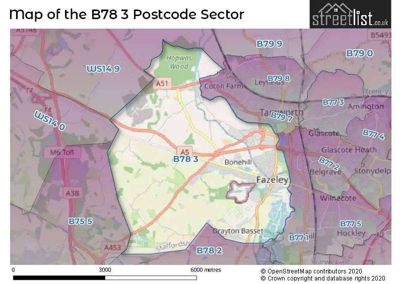
The B78 3 Postcode shares a border with WS14 0 (LICHFIELD, Shenstone, Weeford), WS14 9 (LICHFIELD, Whittington, Whittington Barracks), B77 1 (TAMWORTH, Dosthill, Two Gates), B75 5 (SUTTON COLDFIELD, Canwell, Bassetts Pole), B78 2 (Kingsbury, Middleton, Piccadilly) and B79 7 (TAMWORTH).
Map of the B78 3 Postcode Sector
Explore the B78 3 postcode sector by using our interactive map.
The sector is within the post town of TAMWORTH.
B78 3 is a postcode sector within the B78 postcode district which is within the B Birmingham postcode area.
The Royal Mail delivery office for the B78 3 postal sector is the Tamworth Delivery Office.
The area of the B78 3 postcode sector is 10.75 square miles which is 27.83 square kilometres or 6,877.18 square acres.
The B78 3 postcode sector is crossed by the A5 Major A road.
Waterways within the B78 3 postcode sector include the Coventry Canal, River Tame, Black Brook, Birmingham and Fazeley Canal.
Your support helps keep this site running!
If you enjoy using this website, consider buying me a coffee to help cover hosting costs.

| B | 7 | 8 | - | 3 | X | X |
| B | 7 | 8 | Space | 3 | Letter | Letter |
Official List of Streets
Mile Oak (22 Streets)
TAMWORTH (62 Streets)
Fazeley (32 Streets)
Bonehill (7 Streets)
Hints (4 Streets)
(18 Streets)
Bangley (1 Streets)
Drayton Bassett (10 Streets)
Hopwas (12 Streets)
Unofficial Streets or Alternative Spellings
Fazeley
BONEHILL MEWS WATLING STREET BONEHILL PARK BONEHILL ROAD BRIDGE BURLEIGH DRIVE CARROWAY HEAD HILL CENTENARY DRIVE CRANEBROOK HILL DRAYTON MANOR FOOTBRIDGE DUNSTALL FARM BRIDGE HOPWAS HAYS HOPWAS HILL HOPWAS WOOD BRIDGE JOLLY SAILOR ROUNDABOUT KNOXS GRAVE LANE LAKESIDE BUSINESS PARK LICHFIELD ROAD BRIDGE LONGBURN CRESCENT MEADOW BANK NEW ROW OLD SCHOOL ROW RIVERDRIVE ROCK HILL SHIRRAL DRIVE SUTTON ROAD BRIDGE SWISS LODGE DRIVE TAMEDRIVE VENTURAL PARK ROAD VICTORY TERRACECanwell
SHIRRALL DRIVELICHFIELD
TAMWORTH ROADWeather Forecast for B78 3
Weather Forecast for Drayton Manor Park
| Time Period | Icon | Description | Temperature | Rain Probability | Wind |
|---|---|---|---|---|---|
| 06:00 to 09:00 | Overcast | 4.0°C (feels like 2.0°C) | 11.00% | S 4 mph | |
| 09:00 to 12:00 | Overcast | 4.0°C (feels like 2.0°C) | 9.00% | S 7 mph | |
| 12:00 to 15:00 | Overcast | 6.0°C (feels like 3.0°C) | 8.00% | S 9 mph | |
| 15:00 to 18:00 | Overcast | 7.0°C (feels like 4.0°C) | 8.00% | S 9 mph | |
| 18:00 to 21:00 | Overcast | 5.0°C (feels like 2.0°C) | 8.00% | SSE 9 mph | |
| 21:00 to 00:00 | Overcast | 4.0°C (feels like 1.0°C) | 8.00% | S 11 mph |
| Time Period | Icon | Description | Temperature | Rain Probability | Wind |
|---|---|---|---|---|---|
| 00:00 to 03:00 | Overcast | 4.0°C (feels like 0.0°C) | 8.00% | S 11 mph | |
| 03:00 to 06:00 | Cloudy | 3.0°C (feels like -1.0°C) | 5.00% | SSE 9 mph | |
| 06:00 to 09:00 | Cloudy | 2.0°C (feels like -1.0°C) | 5.00% | SSE 9 mph | |
| 09:00 to 12:00 | Partly cloudy (day) | 2.0°C (feels like -1.0°C) | 4.00% | SSE 9 mph | |
| 12:00 to 15:00 | Cloudy | 5.0°C (feels like 2.0°C) | 6.00% | S 9 mph | |
| 15:00 to 18:00 | Partly cloudy (day) | 7.0°C (feels like 4.0°C) | 4.00% | SSW 7 mph | |
| 18:00 to 21:00 | Cloudy | 5.0°C (feels like 3.0°C) | 5.00% | SSW 4 mph | |
| 21:00 to 00:00 | Clear night | 4.0°C (feels like 1.0°C) | 2.00% | SSW 7 mph |
| Time Period | Icon | Description | Temperature | Rain Probability | Wind |
|---|---|---|---|---|---|
| 00:00 to 03:00 | Partly cloudy (night) | 3.0°C (feels like 1.0°C) | 2.00% | SSW 7 mph | |
| 03:00 to 06:00 | Cloudy | 3.0°C (feels like 0.0°C) | 5.00% | SSW 7 mph | |
| 06:00 to 09:00 | Overcast | 3.0°C (feels like 0.0°C) | 8.00% | SSW 7 mph | |
| 09:00 to 12:00 | Overcast | 4.0°C (feels like 1.0°C) | 9.00% | SSW 9 mph | |
| 12:00 to 15:00 | Overcast | 7.0°C (feels like 4.0°C) | 7.00% | SSW 11 mph | |
| 15:00 to 18:00 | Cloudy | 8.0°C (feels like 6.0°C) | 5.00% | SSW 11 mph | |
| 18:00 to 21:00 | Cloudy | 7.0°C (feels like 4.0°C) | 5.00% | SSW 9 mph | |
| 21:00 to 00:00 | Cloudy | 7.0°C (feels like 3.0°C) | 6.00% | S 11 mph |
| Time Period | Icon | Description | Temperature | Rain Probability | Wind |
|---|---|---|---|---|---|
| 00:00 to 03:00 | Cloudy | 7.0°C (feels like 3.0°C) | 9.00% | SSW 13 mph | |
| 03:00 to 06:00 | Overcast | 7.0°C (feels like 3.0°C) | 16.00% | SSW 13 mph | |
| 06:00 to 09:00 | Overcast | 7.0°C (feels like 3.0°C) | 20.00% | SSW 13 mph | |
| 09:00 to 12:00 | Overcast | 7.0°C (feels like 4.0°C) | 22.00% | SSW 13 mph | |
| 12:00 to 15:00 | Overcast | 9.0°C (feels like 6.0°C) | 21.00% | SSW 13 mph | |
| 15:00 to 18:00 | Light rain | 10.0°C (feels like 7.0°C) | 45.00% | SW 11 mph | |
| 18:00 to 21:00 | Partly cloudy (night) | 8.0°C (feels like 6.0°C) | 14.00% | WSW 9 mph | |
| 21:00 to 00:00 | Partly cloudy (night) | 7.0°C (feels like 4.0°C) | 8.00% | WSW 9 mph |
Schools and Places of Education Within the B78 3 Postcode Sector
Longwood Primary School
Foundation school
Allton Avenue, Tamworth, Staffordshire, B78 3NH
Head: Mrs P James
Ofsted Rating: Good
Inspection: 2019-11-12 (1908 days ago)
Website: Visit Longwood Primary School Website
Phone: 01827213970
Number of Pupils: 168
Millfield Primary School
Community school
Coleshill Street, Tamworth, Staffordshire, B78 3RQ
Head: Mr Simon Kelly
Ofsted Rating: Good
Inspection: 2022-09-22 (863 days ago)
Website: Visit Millfield Primary School Website
Phone: 01827213825
Number of Pupils: 385
Thomas Barnes Primary School
Foundation school
School Lane, Tamworth, Staffordshire, B78 3AD
Head: Mrs E Tibbitts
Ofsted Rating: Outstanding
Inspection: 2014-03-28 (3963 days ago)
Website: Visit Thomas Barnes Primary School Website
Phone: 01827213840
Number of Pupils: 106
House Prices in the B78 3 Postcode Sector
| Type of Property | 2018 Average | 2018 Sales | 2017 Average | 2017 Sales | 2016 Average | 2016 Sales | 2015 Average | 2015 Sales |
|---|---|---|---|---|---|---|---|---|
| Detached | £359,760 | 50 | £340,661 | 54 | £341,313 | 51 | £304,701 | 49 |
| Semi-Detached | £215,655 | 66 | £203,700 | 59 | £171,876 | 51 | £168,726 | 56 |
| Terraced | £199,883 | 24 | £173,324 | 23 | £170,341 | 35 | £167,681 | 32 |
| Flats | £133,821 | 14 | £156,235 | 17 | £120,969 | 18 | £117,318 | 11 |
Important Postcodes B78 3 in the Postcode Sector
B78 3AD is the postcode for Thomas Barnes Cp School, School Lane
B78 3HF is the postcode for Merlin House, Etchell Road
B78 3NG is the postcode for South Staffordshire PCT, Sir Robert Peel Hospital, Midlands Partnership NHS Foundation Trust, George Bryan Centre, Sir Robert Peel Hospital, Plantation Lane, Mile Oak, and Sir Robert Peel Hospital, Plantation Lane
B78 3NH is the postcode for Longwood Primary School, Allton Avenue, and LONGWOOD PRIMARY SCHOOL, ALLTON AVENUE, MILE OAK
B78 3RQ is the postcode for Staffordshire County Council, Millfield County Primary School, Coleshill Street, and MILLFIELD PRIMARY SCHOOL, COLESHILL STREET, FAZELEY
B78 3TX is the postcode for Staffordshire County Council, Manor Cp School, Drayton Lane
| The B78 3 Sector is within these Local Authorities |
|
|---|---|
| The B78 3 Sector is within these Counties |
|
| The B78 3 Sector is within these Water Company Areas |
|
Tourist Attractions within the B78 3 Postcode Area
We found 1 visitor attractions within the B78 postcode area
| Drayton Manor Theme Park |
|---|
| Leisure / Theme Parks |
| Leisure / Theme Park |
| View Drayton Manor Theme Park on Google Maps |