A wide range of spatial data has been analysed to present this overview of the B71 3 Postcode sector. If you would like anything added, please contact us.
The B71 3 West Bromwich (West Bromwich) Postcode Sector
The B71 3 postcode sector is within the county of West Midlands.
Did you know? According to the 2021 Census, the B71 3 postcode sector is home to a bustling 9,702 residents!
Given that each sector allows for 400 unique postcode combinations. Letters C, I, K, M, O and V are not allowed in the last two letters of a postcode. With 184 postcodes already in use, this leaves 216 units available.
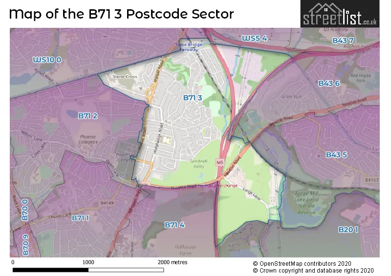
The B71 3 postal code covers the settlement of WEST BROMWICH.
The B71 3 Postcode shares a border with WS5 4 (WALSALL), B20 1 (BIRMINGHAM), B43 5 (BIRMINGHAM, Great Barr), WS10 0 (WEDNESBURY), B43 6 (BIRMINGHAM, Great Barr), B71 1 (WEST BROMWICH), B71 2 (WEST BROMWICH) and B71 4 (WEST BROMWICH, Sandwell).
Map of the B71 3 Postcode Sector
Explore the B71 3 postcode sector by using our interactive map.
The sector is within the post town of WEST BROMWICH.
B71 3 is a postcode sector within the B71 postcode district which is within the B Birmingham postcode area.
The Royal Mail delivery office for the B71 3 postal sector is the West Bromwich Delivery Office.
The area of the B71 3 postcode sector is 1.38 square miles which is 3.58 square kilometres or 885.41 square acres.
The B71 3 postcode sector is crossed by the M5 motorway.
The B71 3 postcode sector is crossed by the M6 motorway.
Waterways within the B71 3 postcode sector include the Tame Valley Canal, River Tame.
Your support helps keep this site running!
If you enjoy using this website, consider buying me a coffee to help cover hosting costs.


| B | 7 | 1 | - | 3 | X | X |
| B | 7 | 1 | Space | 3 | Letter | Letter |
Official List of Streets
WEST BROMWICH (85 Streets)
(3 Streets)
Unofficial Streets or Alternative Spellings
WEST BROMWICH
ALL SAINTS WAY BEVERLEY ROAD CALDWELL STREET HEATH LANE MARSH LANE PRINCESS GROVE WESTMINSTER ROAD BEACON VIEW ROAD CHURCHVIEW WALK CRANKHALL LANE BRIDGE FRIAR PARK FARM BRIDGE M5 BRIDGE RAMSAY CLOSEHandsworth
PARK LANEFriar Park
WALSALL ROADGreat Barr
NEWTON ROADWEDNESBURY,
CRANKHALL LANEWeather Forecast for B71 3
Weather Forecast for Bird End
| Time Period | Icon | Description | Temperature | Rain Probability | Wind |
|---|---|---|---|---|---|
| 00:00 to 03:00 | Light rain | 8.0°C (feels like 5.0°C) | 50.00% | S 13 mph | |
| 03:00 to 06:00 | Light rain | 9.0°C (feels like 6.0°C) | 49.00% | S 13 mph | |
| 06:00 to 09:00 | Light rain | 10.0°C (feels like 7.0°C) | 47.00% | S 13 mph | |
| 09:00 to 12:00 | Overcast | 11.0°C (feels like 8.0°C) | 47.00% | S 16 mph | |
| 12:00 to 15:00 | Overcast | 12.0°C (feels like 9.0°C) | 46.00% | SSW 18 mph | |
| 15:00 to 18:00 | Light rain shower (day) | 13.0°C (feels like 10.0°C) | 35.00% | SW 16 mph | |
| 18:00 to 21:00 | Cloudy | 11.0°C (feels like 9.0°C) | 7.00% | SSW 13 mph | |
| 21:00 to 00:00 | Cloudy | 10.0°C (feels like 8.0°C) | 8.00% | SSW 11 mph |
| Time Period | Icon | Description | Temperature | Rain Probability | Wind |
|---|---|---|---|---|---|
| 00:00 to 03:00 | Overcast | 10.0°C (feels like 8.0°C) | 8.00% | S 11 mph | |
| 03:00 to 06:00 | Overcast | 11.0°C (feels like 8.0°C) | 16.00% | S 13 mph | |
| 06:00 to 09:00 | Light rain | 11.0°C (feels like 8.0°C) | 53.00% | S 16 mph | |
| 09:00 to 12:00 | Light rain | 11.0°C (feels like 8.0°C) | 51.00% | S 18 mph | |
| 12:00 to 15:00 | Cloudy | 13.0°C (feels like 9.0°C) | 17.00% | S 20 mph | |
| 15:00 to 18:00 | Heavy rain | 12.0°C (feels like 9.0°C) | 75.00% | S 20 mph | |
| 18:00 to 21:00 | Light rain | 11.0°C (feels like 8.0°C) | 54.00% | SSW 16 mph | |
| 21:00 to 00:00 | Cloudy | 10.0°C (feels like 7.0°C) | 12.00% | SSW 11 mph |
| Time Period | Icon | Description | Temperature | Rain Probability | Wind |
|---|---|---|---|---|---|
| 00:00 to 03:00 | Cloudy | 9.0°C (feels like 7.0°C) | 7.00% | SSW 9 mph | |
| 03:00 to 06:00 | Cloudy | 8.0°C (feels like 6.0°C) | 9.00% | SSW 7 mph | |
| 06:00 to 09:00 | Overcast | 8.0°C (feels like 6.0°C) | 9.00% | SSW 7 mph | |
| 09:00 to 12:00 | Cloudy | 8.0°C (feels like 6.0°C) | 6.00% | SW 7 mph | |
| 12:00 to 15:00 | Cloudy | 10.0°C (feels like 9.0°C) | 7.00% | SW 9 mph | |
| 15:00 to 18:00 | Partly cloudy (day) | 12.0°C (feels like 10.0°C) | 7.00% | SW 9 mph | |
| 18:00 to 21:00 | Clear night | 10.0°C (feels like 8.0°C) | 3.00% | SW 7 mph | |
| 21:00 to 00:00 | Clear night | 8.0°C (feels like 5.0°C) | 1.00% | SSW 9 mph |
| Time Period | Icon | Description | Temperature | Rain Probability | Wind |
|---|---|---|---|---|---|
| 00:00 to 03:00 | Partly cloudy (night) | 7.0°C (feels like 4.0°C) | 2.00% | SSW 9 mph | |
| 03:00 to 06:00 | Cloudy | 7.0°C (feels like 3.0°C) | 8.00% | S 13 mph | |
| 06:00 to 09:00 | Cloudy | 7.0°C (feels like 4.0°C) | 12.00% | S 16 mph | |
| 09:00 to 12:00 | Cloudy | 9.0°C (feels like 5.0°C) | 21.00% | S 18 mph | |
| 12:00 to 15:00 | Light rain | 10.0°C (feels like 7.0°C) | 51.00% | SSW 20 mph | |
| 15:00 to 18:00 | Light rain | 11.0°C (feels like 8.0°C) | 54.00% | SSW 20 mph | |
| 18:00 to 21:00 | Light rain | 11.0°C (feels like 8.0°C) | 52.00% | SSW 18 mph | |
| 21:00 to 00:00 | Light rain | 10.0°C (feels like 7.0°C) | 49.00% | SW 18 mph |
Schools and Places of Education Within the B71 3 Postcode Sector
Pennyhill Primary School
Community school
Hollyhedge Road, West Bromwich, West Midlands, B71 3BU
Head: Miss Elaine Williams
Ofsted Rating: Good
Inspection: 2022-03-16 (1072 days ago)
Website: Visit Pennyhill Primary School Website
Phone: 01215882230
Number of Pupils: 633
House Prices in the B71 3 Postcode Sector
| Type of Property | 2018 Average | 2018 Sales | 2017 Average | 2017 Sales | 2016 Average | 2016 Sales | 2015 Average | 2015 Sales |
|---|---|---|---|---|---|---|---|---|
| Detached | £270,870 | 22 | £250,370 | 20 | £217,265 | 27 | £216,847 | 19 |
| Semi-Detached | £167,780 | 51 | £171,132 | 53 | £155,524 | 39 | £142,446 | 48 |
| Terraced | £149,367 | 30 | £132,603 | 29 | £114,737 | 23 | £121,004 | 24 |
| Flats | £67,548 | 24 | £76,329 | 31 | £80,595 | 42 | £50,433 | 23 |
Important Postcodes B71 3 in the Postcode Sector
B71 3BU is the postcode for The Annexe, Pennyhill Primary School, Hollyhedge Road, and Pennyhill Primary School, Hollyhedge Road
B71 3DJ is the postcode for Inclusion Support, Connor Road
B71 3PJ is the postcode for Charlemount Community Centre, 369 Beaconview Road
B71 3SX is the postcode for West Bromwich Crematorium, Forge Lane
| The B71 3 Sector is within these Local Authorities |
|
|---|---|
| The B71 3 Sector is within these Counties |
|
| The B71 3 Sector is within these Water Company Areas |
|