A wide range of spatial data has been analysed to present this overview of the B70 8 Postcode sector. If you would like anything added, please contact us.
The B70 8 postcode sector is within the county of West Midlands.
Did you know? According to the 2021 Census, the B70 8 postcode sector is home to a bustling 5,405 residents!
Given that each sector allows for 400 unique postcode combinations. Letters C, I, K, M, O and V are not allowed in the last two letters of a postcode. With 130 postcodes already in use, this leaves 270 units available.
The B70 8 postal code covers the settlement of WEST BROMWICH.
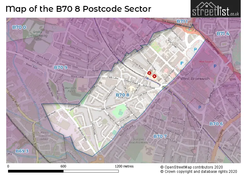
The B70 8 Postcode shares a border with B70 7 (WEST BROMWICH, Lyng), B70 9 (WEST BROMWICH), B71 1 (WEST BROMWICH) and B71 4 (WEST BROMWICH, Sandwell).
Map of the B70 8 Postcode Sector
Explore the B70 8 postcode sector by using our interactive map.
The sector is within the post town of WEST BROMWICH.
B70 8 is a postcode sector within the B70 postcode district which is within the B Birmingham postcode area.
The Royal Mail delivery office for the B70 8 postal sector is the West Bromwich Delivery Office.
The area of the B70 8 postcode sector is 0.38 square miles which is 0.98 square kilometres or 242.64 square acres.
Your support helps keep this site running!
If you enjoy using this website, consider buying me a coffee to help cover hosting costs.


| B | 7 | 0 | - | 8 | X | X |
| B | 7 | 0 | Space | 8 | Letter | Letter |
Official List of Streets
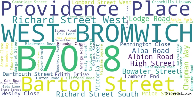
WEST BROMWICH (52 Streets)
Unofficial Streets or Alternative Spellings
Weather Forecast for B70 8
Weather Forecast for Guns Village
| Time Period | Icon | Description | Temperature | Rain Probability | Wind |
|---|---|---|---|---|---|
| 00:00 to 03:00 | Mist | -2.0°C (feels like -4.0°C) | 16.00% | ENE 4 mph | |
| 03:00 to 06:00 | Fog | -2.0°C (feels like -4.0°C) | 18.00% | ENE 4 mph | |
| 06:00 to 09:00 | Fog | -2.0°C (feels like -5.0°C) | 18.00% | ENE 4 mph | |
| 09:00 to 12:00 | Fog | -3.0°C (feels like -5.0°C) | 18.00% | NE 2 mph | |
| 12:00 to 15:00 | Fog | -1.0°C (feels like -3.0°C) | 17.00% | WNW 2 mph | |
| 15:00 to 18:00 | Cloudy | 0.0°C (feels like -2.0°C) | 8.00% | ESE 2 mph | |
| 18:00 to 21:00 | Fog | -1.0°C (feels like -3.0°C) | 17.00% | S 4 mph | |
| 21:00 to 00:00 | Mist | -1.0°C (feels like -4.0°C) | 17.00% | S 4 mph |
| Time Period | Icon | Description | Temperature | Rain Probability | Wind |
|---|---|---|---|---|---|
| 00:00 to 03:00 | Mist | -1.0°C (feels like -4.0°C) | 18.00% | S 4 mph | |
| 03:00 to 06:00 | Mist | -1.0°C (feels like -4.0°C) | 17.00% | S 4 mph | |
| 06:00 to 09:00 | Mist | -1.0°C (feels like -5.0°C) | 16.00% | S 7 mph | |
| 09:00 to 12:00 | Mist | -1.0°C (feels like -5.0°C) | 14.00% | S 7 mph | |
| 12:00 to 15:00 | Cloudy | 1.0°C (feels like -2.0°C) | 5.00% | S 7 mph | |
| 15:00 to 18:00 | Cloudy | 3.0°C (feels like -1.0°C) | 5.00% | S 9 mph | |
| 18:00 to 21:00 | Cloudy | 2.0°C (feels like -2.0°C) | 5.00% | S 9 mph | |
| 21:00 to 00:00 | Cloudy | 1.0°C (feels like -3.0°C) | 5.00% | SSW 11 mph |
| Time Period | Icon | Description | Temperature | Rain Probability | Wind |
|---|---|---|---|---|---|
| 00:00 to 03:00 | Cloudy | 2.0°C (feels like -3.0°C) | 5.00% | SSW 11 mph | |
| 03:00 to 06:00 | Cloudy | 2.0°C (feels like -3.0°C) | 5.00% | SSW 13 mph | |
| 06:00 to 09:00 | Cloudy | 2.0°C (feels like -3.0°C) | 5.00% | SSW 13 mph | |
| 09:00 to 12:00 | Cloudy | 3.0°C (feels like -2.0°C) | 5.00% | SSW 13 mph | |
| 12:00 to 15:00 | Cloudy | 5.0°C (feels like 1.0°C) | 5.00% | SSW 13 mph | |
| 15:00 to 18:00 | Cloudy | 6.0°C (feels like 2.0°C) | 6.00% | SW 13 mph | |
| 18:00 to 21:00 | Overcast | 5.0°C (feels like 2.0°C) | 9.00% | SW 11 mph | |
| 21:00 to 00:00 | Overcast | 5.0°C (feels like 2.0°C) | 9.00% | SW 11 mph |
| Time Period | Icon | Description | Temperature | Rain Probability | Wind |
|---|---|---|---|---|---|
| 00:00 to 03:00 | Overcast | 6.0°C (feels like 2.0°C) | 8.00% | SW 11 mph | |
| 03:00 to 06:00 | Overcast | 6.0°C (feels like 3.0°C) | 8.00% | SW 9 mph | |
| 06:00 to 09:00 | Overcast | 6.0°C (feels like 3.0°C) | 9.00% | SW 9 mph | |
| 09:00 to 12:00 | Overcast | 7.0°C (feels like 4.0°C) | 8.00% | SW 9 mph | |
| 12:00 to 15:00 | Overcast | 9.0°C (feels like 6.0°C) | 9.00% | WSW 9 mph | |
| 15:00 to 18:00 | Overcast | 9.0°C (feels like 7.0°C) | 8.00% | WSW 9 mph | |
| 18:00 to 21:00 | Overcast | 8.0°C (feels like 6.0°C) | 8.00% | SW 9 mph | |
| 21:00 to 00:00 | Overcast | 8.0°C (feels like 5.0°C) | 9.00% | SW 9 mph |
Schools and Places of Education Within the B70 8 Postcode Sector
Lodge Primary School
Community school
Oak Lane, West Bromwich, West Midlands, B70 8PN
Head: Headteacher Tahirah Khatun
Ofsted Rating: Good
Inspection: 2020-02-05 (1802 days ago)
Website: Visit Lodge Primary School Website
Phone: 01215532389
Number of Pupils: 446
Shireland Biomedical Utc
University technical college
350 High Street, West Bromwich, West Midlands, B70 8DJ
Head: Ms Andrea Stephens
Ofsted Rating: Requires improvement
Inspection: 2023-11-29 (409 days ago)
Website: Visit Shireland Biomedical Utc Website
Phone: 01218281123
Number of Pupils: 215
The British Muslim School
Other independent school
Latifiah Fultali Complex, West Midlands, West Midlands, B70 8NX
Head: Mr Muhammad Kadir Al Hasan
Ofsted Rating: Requires improvement
Inspection: 2022-05-26 (961 days ago)
Website: Visit The British Muslim School Website
Phone: 01215162264
Number of Pupils: 83

House Prices in the B70 8 Postcode Sector
| Type of Property | 2018 Average | 2018 Sales | 2017 Average | 2017 Sales | 2016 Average | 2016 Sales | 2015 Average | 2015 Sales |
|---|---|---|---|---|---|---|---|---|
| Detached | £235,000 | 1 | £150,000 | 1 | £200,000 | 1 | £0 | 0 |
| Semi-Detached | £140,000 | 6 | £132,100 | 10 | £119,000 | 3 | £122,667 | 3 |
| Terraced | £122,353 | 17 | £113,367 | 25 | £95,921 | 19 | £99,011 | 22 |
| Flats | £74,842 | 6 | £44,488 | 6 | £64,167 | 3 | £90,000 | 1 |
Important Postcodes B70 8 in the Postcode Sector
B70 8AY is the postcode for West Bromwich Town Hal, High Street
B70 8DW is the postcode for RYLANDS BUILDING, Sandwell College, High Street, GRAMMAR SCHOOL BUILDING, Sandwell College, High Street, and MAIN BUILDING, Sandwell College, High Street
B70 8DY is the postcode for West Bromwich Town Hall, Lodge Road
B70 8DZ is the postcode for Central Library, High Street
B70 8ED is the postcode for West Bromwich Magistrates Court, Lombard Street West
B70 8HJ is the postcode for Oak House Visitor Centre, 190 Oak Road, and OAK HOUSE MUSEUM, Oak House Visitor Centre, 190 Oak Road
B70 8LG is the postcode for Jobcentre Plus, Christchurch House, High Street
B70 8LU is the postcode for Sandwell Metropolitan Borough Council, Court House, and Court House, 335-337 High Street
B70 8NL is the postcode for Edward Street Hospital, Edward Street, Sandwell Mental Health NHS and Social Care Trust, Edward Street Hospital, and Edward Street Community Team Base, Edward Street
B70 8NY is the postcode for Sandwell Mental Health & Social Care Trust, 48 Lodge Road
B70 8PJ is the postcode for Lodge Road Youth Centre, Lodge Road
B70 8PW is the postcode for Lodge Primary School, Oak Lane
B70 8RJ is the postcode for Highfields, High Street, Sandwell Register Office, Highfields, High Street, Highfields Registry, High Street, and Highfields Registry, Highfields
B70 8RT is the postcode for 5 Lombard Street, and Environment House, Lombard Street
B70 8RU is the postcode for Development House, PO Box 42
B70 8SZ is the postcode for 1 Providence Place, 1 PROVIDENCE PLACE, WEST BROMWICH, and Transform Sandwell, 1 Providence Place
| The B70 8 Sector is within these Local Authorities |
|
|---|---|
| The B70 8 Sector is within these Counties |
|
| The B70 8 Sector is within these Water Company Areas |
|