A wide range of spatial data has been analysed to present this overview of the B69 2 Postcode sector. If you would like anything added, please contact us.
The B69 2 postcode sector is within the county of West Midlands.
Did you know? According to the 2021 Census, the B69 2 postcode sector is home to a bustling 6,038 residents!
Given that each sector allows for 400 unique postcode combinations. Letters C, I, K, M, O and V are not allowed in the last two letters of a postcode. With 146 postcodes already in use, this leaves 254 units available.
The largest settlements in the B69 2 postal code are OLDBURY and Tividale.
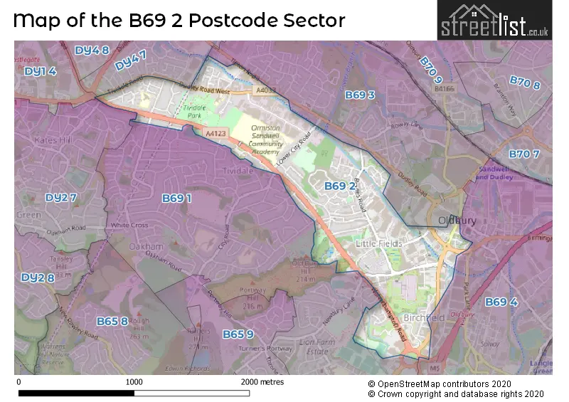
The B69 2 Postcode shares a border with DY1 4 (DUDLEY, Woodsetton), DY2 7 (DUDLEY), DY4 7 (TIPTON, Great Bridge), B69 3 (Tividale, OLDBURY), B69 4 (OLDBURY) and B69 1 (Tividale, OLDBURY).
Map of the B69 2 Postcode Sector
Explore the B69 2 postcode sector by using our interactive map.
The sector is within the post town of OLDBURY.
B69 2 is a postcode sector within the B69 postcode district which is within the B Birmingham postcode area.
The Royal Mail delivery office for the B69 2 postal sector is the Oldbury Delivery Office.
The area of the B69 2 postcode sector is 0.94 square miles which is 2.44 square kilometres or 601.80 square acres.
The B69 2 postcode sector is crossed by the A4123 Major A road.
Waterways within the B69 2 postcode sector include the Netherton Tunnel Branch (BCN), Gower Branch, Old Main Line (Birmingham Canal Navigations), Netherton Tunnel; Dudley No.2 Canal.
Your support helps keep this site running!
If you enjoy using this website, consider buying me a coffee to help cover hosting costs.


| B | 6 | 9 | - | 2 | X | X |
| B | 6 | 9 | Space | 2 | Letter | Letter |
Official List of Streets
Tividale (30 Streets)
OLDBURY (48 Streets)
Unofficial Streets or Alternative Spellings
OLDBURY
CANAL STREET DEMUTH WAY NEWBURY LANE OLDBURY RINGWAY PARK STREET BIRCHLEY ISLAND BRADES BRIDGE BUNNS LANE CHAPEL STREET CHURCH BRIDGE STREET DUDLEY ROAD BRIDGE EDALE DRIVE FISHERS BRIDGE HIGH BRIDGE INKERMAN STREET JOHNS LANE LATIMER SQUARE LITTLE EEL STREET LITTLEFIELDS WAY LOOP LANE MARL HOLE LANE OLDBURY RING WAY PIGEONBOX ROAD RATCLIFFE WALK SWALLOWFIELDS TIPPEARY WALK WHIMSEY BRIDGE WOLVERHAMPTON ROAD (PLANNED ROUTE) WOLVERHAMPTON ROAD (PROPOSED ROUTE)Tividale
CITY ROAD CROSS WALK HAMILTON DRIVE HILTON ROAD PACKWOOD ROAD REGENT ROAD TIPTON ROAD TOWER ROAD TRAFALGAR ROADTIPTON
CHURCH STREET GATE STREET HOPKINS STREET TIVIDALE STREETDUDLEY
BIRMINGHAM ROAD BUNNS LANEWeather Forecast for B69 2
Weather Forecast for Tividale
| Time Period | Icon | Description | Temperature | Rain Probability | Wind |
|---|---|---|---|---|---|
| 03:00 to 06:00 | Overcast | 7.0°C (feels like 4.0°C) | 9.00% | SSW 13 mph | |
| 06:00 to 09:00 | Cloudy | 7.0°C (feels like 3.0°C) | 9.00% | SSW 16 mph | |
| 09:00 to 12:00 | Cloudy | 8.0°C (feels like 4.0°C) | 6.00% | SW 18 mph | |
| 12:00 to 15:00 | Cloudy | 9.0°C (feels like 5.0°C) | 11.00% | SW 20 mph | |
| 15:00 to 18:00 | Light rain | 10.0°C (feels like 6.0°C) | 56.00% | SW 20 mph | |
| 18:00 to 21:00 | Heavy rain | 9.0°C (feels like 6.0°C) | 80.00% | SW 20 mph | |
| 21:00 to 00:00 | Light rain | 9.0°C (feels like 6.0°C) | 61.00% | SW 18 mph |
| Time Period | Icon | Description | Temperature | Rain Probability | Wind |
|---|---|---|---|---|---|
| 00:00 to 03:00 | Heavy rain | 9.0°C (feels like 6.0°C) | 81.00% | WSW 16 mph | |
| 03:00 to 06:00 | Light rain | 8.0°C (feels like 5.0°C) | 60.00% | WSW 13 mph | |
| 06:00 to 09:00 | Heavy rain | 8.0°C (feels like 5.0°C) | 76.00% | SW 13 mph | |
| 09:00 to 12:00 | Heavy rain | 7.0°C (feels like 4.0°C) | 86.00% | SW 16 mph | |
| 12:00 to 15:00 | Heavy rain | 8.0°C (feels like 4.0°C) | 91.00% | SSW 18 mph | |
| 15:00 to 18:00 | Heavy rain | 8.0°C (feels like 4.0°C) | 90.00% | WSW 20 mph | |
| 18:00 to 21:00 | Heavy rain | 5.0°C (feels like 1.0°C) | 75.00% | W 16 mph | |
| 21:00 to 00:00 | Cloudy | 3.0°C (feels like -1.0°C) | 28.00% | WNW 11 mph |
| Time Period | Icon | Description | Temperature | Rain Probability | Wind |
|---|---|---|---|---|---|
| 00:00 to 03:00 | Partly cloudy (night) | 2.0°C (feels like -1.0°C) | 15.00% | NW 9 mph | |
| 03:00 to 06:00 | Clear night | 1.0°C (feels like -3.0°C) | 7.00% | NNW 9 mph | |
| 06:00 to 09:00 | Clear night | 0.0°C (feels like -4.0°C) | 4.00% | NNW 7 mph | |
| 09:00 to 12:00 | Sunny day | -1.0°C (feels like -4.0°C) | 2.00% | NNW 7 mph | |
| 12:00 to 15:00 | Sunny day | 1.0°C (feels like -2.0°C) | 2.00% | NNW 7 mph | |
| 15:00 to 18:00 | Sunny day | 2.0°C (feels like -1.0°C) | 2.00% | NNW 7 mph | |
| 18:00 to 21:00 | Clear night | 0.0°C (feels like -4.0°C) | 0.00% | NNW 7 mph | |
| 21:00 to 00:00 | Clear night | -2.0°C (feels like -5.0°C) | 0.00% | NNW 7 mph |
| Time Period | Icon | Description | Temperature | Rain Probability | Wind |
|---|---|---|---|---|---|
| 00:00 to 03:00 | Clear night | -2.0°C (feels like -6.0°C) | 1.00% | NNW 4 mph | |
| 03:00 to 06:00 | Clear night | -3.0°C (feels like -6.0°C) | 1.00% | NW 4 mph | |
| 06:00 to 09:00 | Clear night | -3.0°C (feels like -7.0°C) | 2.00% | WNW 7 mph | |
| 09:00 to 12:00 | Sunny day | -3.0°C (feels like -6.0°C) | 2.00% | WNW 7 mph | |
| 12:00 to 15:00 | Sunny day | 1.0°C (feels like -3.0°C) | 1.00% | WNW 7 mph | |
| 15:00 to 18:00 | Sunny day | 2.0°C (feels like -2.0°C) | 1.00% | W 7 mph | |
| 18:00 to 21:00 | Clear night | 0.0°C (feels like -3.0°C) | 2.00% | W 9 mph | |
| 21:00 to 00:00 | Clear night | 0.0°C (feels like -4.0°C) | 3.00% | W 9 mph |
Schools and Places of Education Within the B69 2 Postcode Sector
Burnt Tree Primary School
Community school
Hill Road, Oldbury, West Midlands, B69 2LN
Head: Mrs Jayne Bayliss
Ofsted Rating: Good
Inspection: 2019-01-30 (2162 days ago)
Website: Visit Burnt Tree Primary School Website
Phone: 01215572967
Number of Pupils: 445
Ormiston Sandwell Community Academy
Academy sponsor led
Lower City Road, Oldbury, West Midlands, B69 2HE
Head: Mr Adrian Price
Ofsted Rating: Good
Inspection: 2023-10-25 (433 days ago)
Website: Visit Ormiston Sandwell Community Academy Website
Phone: 01215525501
Number of Pupils: 1141
Tividale Community Primary School
Community school
Dudley Road West, Oldbury, West Midlands, B69 2HT
Head: Mrs Premjit Dosanjh
Ofsted Rating: Good
Inspection: 2023-10-25 (433 days ago)
Website: Visit Tividale Community Primary School Website
Phone: 01215571765
Number of Pupils: 467
House Prices in the B69 2 Postcode Sector
| Type of Property | 2018 Average | 2018 Sales | 2017 Average | 2017 Sales | 2016 Average | 2016 Sales | 2015 Average | 2015 Sales |
|---|---|---|---|---|---|---|---|---|
| Detached | £232,205 | 17 | £226,763 | 19 | £212,198 | 24 | £224,148 | 32 |
| Semi-Detached | £143,173 | 26 | £143,780 | 25 | £134,572 | 25 | £132,619 | 36 |
| Terraced | £129,970 | 35 | £138,857 | 55 | £111,210 | 26 | £119,744 | 35 |
| Flats | £65,444 | 9 | £60,636 | 11 | £71,904 | 13 | £61,433 | 15 |
Important Postcodes B69 2 in the Postcode Sector
B69 2AJ is the postcode for Oldbury Library, Jack Judge House, 10 Halesowen Street, and Jack Judge House, 10 Halesowen Street
B69 2BP is the postcode for Shidas Lane Depot, Shidas Lane
B69 2DF is the postcode for APOLLO HOUSE, ROUNDS GREEN ROAD
B69 2DG is the postcode for Quayside House, Round Greens Road
B69 2DP is the postcode for Rounds Green Primary School, Brades Road
B69 2HA is the postcode for The Brades Lodge, Lower City Road, Tividale, and The Brades Lodge, Lower City Road
B69 2HE is the postcode for Tividale High School & Community College, Lower City Road, A BLOCK, Ormiston Sandwell Community Academy, Lower City Road, O BLOCK, Ormiston Sandwell Community Academy, Lower City Road, MAIN BLOCK, Ormiston Sandwell Community Academy, Lower City Road, LIBRARY BLOCK, Ormiston Sandwell Community Academy, Lower City Road, C BLOCK, Ormiston Sandwell Community Academy, Lower City Road, NEW BLOCK, Ormiston Sandwell Community Academy, Lower City Road, and S BLOCK, Ormiston Sandwell Community Academy, Lower City Road
B69 2HT is the postcode for Tividale Community Primary School, Dudley Road West, and Tividale Community Primary School, Dudley Road West, Tividale
B69 2LN is the postcode for Burnt Tree Primary School, Hill Road, and Burnt Tree Primary School, Hill Road, Tividale
| The B69 2 Sector is within these Local Authorities |
|
|---|---|
| The B69 2 Sector is within these Counties |
|
| The B69 2 Sector is within these Water Company Areas |
|