A wide range of spatial data has been analysed to present this overview of the B68 0 Postcode sector. If you would like anything added, please contact us.
The B68 0 postcode sector is within the county of West Midlands.
Did you know? According to the 2021 Census, the B68 0 postcode sector is home to a bustling 9,779 residents!
Given that each sector allows for 400 unique postcode combinations. Letters C, I, K, M, O and V are not allowed in the last two letters of a postcode. With 183 postcodes already in use, this leaves 217 units available.
The B68 0 postal code covers the settlement of OLDBURY.
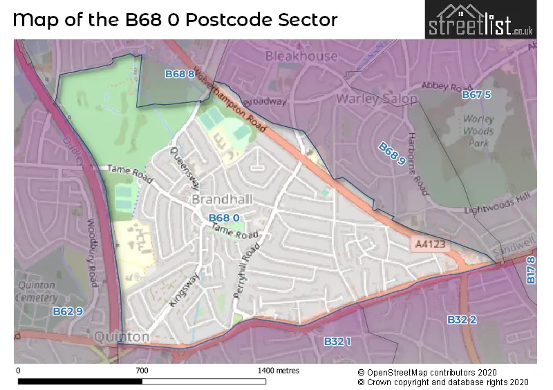
The B68 0 Postcode shares a border with B32 1 (Quinton, BIRMINGHAM), B68 9 (OLDBURY), B32 2 (Quinton, BIRMINGHAM, Harborne), B62 9 (HALESOWEN, Hurst Green) and B68 8 (OLDBURY).
Map of the B68 0 Postcode Sector
Explore the B68 0 postcode sector by using our interactive map.
The sector is within the post town of OLDBURY.
B68 0 is a postcode sector within the B68 postcode district which is within the B Birmingham postcode area.
The Royal Mail delivery office for the B68 0 postal sector is the Oldbury Delivery Office.
The area of the B68 0 postcode sector is 0.79 square miles which is 2.04 square kilometres or 504.89 square acres.
Your support helps keep this site running!
If you enjoy using this website, consider buying me a coffee to help cover hosting costs.


| B | 6 | 8 | - | 0 | X | X |
| B | 6 | 8 | Space | 0 | Letter | Letter |
Official List of Streets
OLDBURY (73 Streets)
Unofficial Streets or Alternative Spellings
Weather Forecast for B68 0
Weather Forecast for Warley
| Time Period | Icon | Description | Temperature | Rain Probability | Wind |
|---|---|---|---|---|---|
| 06:00 to 09:00 | Cloudy | 6.0°C (feels like 2.0°C) | 5.00% | SSW 18 mph | |
| 09:00 to 12:00 | Cloudy | 7.0°C (feels like 3.0°C) | 6.00% | SSW 18 mph | |
| 12:00 to 15:00 | Overcast | 9.0°C (feels like 5.0°C) | 23.00% | SSW 20 mph | |
| 15:00 to 18:00 | Heavy rain | 8.0°C (feels like 5.0°C) | 88.00% | SSW 18 mph | |
| 18:00 to 21:00 | Partly cloudy (night) | 7.0°C (feels like 4.0°C) | 38.00% | SW 13 mph | |
| 21:00 to 00:00 | Clear night | 5.0°C (feels like 2.0°C) | 1.00% | SW 13 mph |
| Time Period | Icon | Description | Temperature | Rain Probability | Wind |
|---|---|---|---|---|---|
| 00:00 to 03:00 | Clear night | 4.0°C (feels like 0.0°C) | 0.00% | WSW 11 mph | |
| 03:00 to 06:00 | Clear night | 3.0°C (feels like -1.0°C) | 1.00% | WSW 11 mph | |
| 06:00 to 09:00 | Clear night | 2.0°C (feels like -1.0°C) | 1.00% | WSW 9 mph | |
| 09:00 to 12:00 | Cloudy | 3.0°C (feels like -1.0°C) | 4.00% | WSW 9 mph | |
| 12:00 to 15:00 | Cloudy | 6.0°C (feels like 4.0°C) | 4.00% | W 7 mph | |
| 15:00 to 18:00 | Cloudy | 7.0°C (feels like 5.0°C) | 4.00% | NW 7 mph | |
| 18:00 to 21:00 | Partly cloudy (night) | 4.0°C (feels like 2.0°C) | 1.00% | NW 4 mph | |
| 21:00 to 00:00 | Clear night | 2.0°C (feels like 0.0°C) | 0.00% | NNW 4 mph |
| Time Period | Icon | Description | Temperature | Rain Probability | Wind |
|---|---|---|---|---|---|
| 00:00 to 03:00 | Clear night | 1.0°C (feels like -1.0°C) | 0.00% | N 4 mph | |
| 03:00 to 06:00 | Clear night | 0.0°C (feels like -3.0°C) | 0.00% | NE 4 mph | |
| 06:00 to 09:00 | Clear night | -1.0°C (feels like -4.0°C) | 2.00% | ENE 4 mph | |
| 09:00 to 12:00 | Sunny day | 0.0°C (feels like -3.0°C) | 2.00% | ENE 7 mph | |
| 12:00 to 15:00 | Sunny day | 4.0°C (feels like 2.0°C) | 0.00% | E 7 mph | |
| 15:00 to 18:00 | Sunny day | 6.0°C (feels like 3.0°C) | 0.00% | E 7 mph | |
| 18:00 to 21:00 | Clear night | 3.0°C (feels like 0.0°C) | 1.00% | ENE 9 mph | |
| 21:00 to 00:00 | Clear night | 2.0°C (feels like -2.0°C) | 1.00% | ENE 9 mph |
| Time Period | Icon | Description | Temperature | Rain Probability | Wind |
|---|---|---|---|---|---|
| 00:00 to 03:00 | Clear night | 1.0°C (feels like -3.0°C) | 1.00% | ENE 9 mph | |
| 03:00 to 06:00 | Mist | 0.0°C (feels like -4.0°C) | 13.00% | ENE 9 mph | |
| 06:00 to 09:00 | Fog | 0.0°C (feels like -4.0°C) | 15.00% | ENE 9 mph | |
| 09:00 to 12:00 | Fog | 1.0°C (feels like -4.0°C) | 15.00% | ENE 9 mph | |
| 12:00 to 15:00 | Cloudy | 3.0°C (feels like -1.0°C) | 6.00% | ENE 9 mph | |
| 15:00 to 18:00 | Sunny day | 4.0°C (feels like 1.0°C) | 2.00% | ENE 9 mph | |
| 18:00 to 21:00 | Clear night | 2.0°C (feels like -1.0°C) | 1.00% | ENE 9 mph | |
| 21:00 to 00:00 | Clear night | 1.0°C (feels like -3.0°C) | 2.00% | ENE 9 mph |
Schools and Places of Education Within the B68 0 Postcode Sector
Brandhall Primary School
Community school
Brennand Road, Oldbury, West Midlands, B68 0SH
Head: Miss Elizabeth Hart
Ofsted Rating: Good
Inspection: 2019-01-24 (2203 days ago)
Website: Visit Brandhall Primary School Website
Phone: 01214225336
Number of Pupils: 476
Perryfields Primary School
Community school
Apsley Road, Oldbury, West Midlands, B68 0QY
Head: Mrs Terry Jones
Ofsted Rating: Good
Inspection: 2022-04-06 (1035 days ago)
Website: Visit Perryfields Primary School Website
Phone: 01214222848
Number of Pupils: 354
House Prices in the B68 0 Postcode Sector
| Type of Property | 2018 Average | 2018 Sales | 2017 Average | 2017 Sales | 2016 Average | 2016 Sales | 2015 Average | 2015 Sales |
|---|---|---|---|---|---|---|---|---|
| Detached | £283,350 | 10 | £224,440 | 12 | £186,967 | 15 | £244,227 | 11 |
| Semi-Detached | £177,782 | 76 | £164,942 | 55 | £160,356 | 71 | £155,936 | 80 |
| Terraced | £175,138 | 64 | £173,759 | 62 | £143,417 | 41 | £142,598 | 45 |
| Flats | £79,083 | 15 | £75,963 | 20 | £105,318 | 14 | £74,717 | 18 |
Important Postcodes B68 0 in the Postcode Sector
B68 0JT is the postcode for Oldbury Local Authority, Brandhall Library, Tame Road
B68 0LP is the postcode for Lightwoods Primary School, Wolverhampton Road, DINING BLOCK, Lightwoods Primary School, Wolverhampton Road, and St. Huberts Primary School, Wolverhampton Road
B68 0QY is the postcode for Perryfields Primary School, Apsley Road
B68 0RG is the postcode for NEW BLOCK, Perryfields Academy, Oldacre Road, Perryfields High School, Oldacre Road, NEW BLOCK, Perryfields High School, Oldacre Road, JUBILEE BLOCK, Perryfields High School, Oldacre Road, MAIN BUILDING, Perryfields Academy, Oldacre Road, JUBILEE BLOCK, Perryfields Academy, Oldacre Road, and SPORTS HALL, Perryfields High School, Oldacre Road
B68 0RT is the postcode for Warley Medical Centre, Ambrose House, Kingsway
B68 0SH is the postcode for Brandhall Primary School, Edinburgh Road
B68 0ST is the postcode for BRANDHALL JUNIORS, Brandhall Primary School, Edinburgh Road, and Brandhall Primary School, Edinburgh Road
| The B68 0 Sector is within these Local Authorities |
|
|---|---|
| The B68 0 Sector is within these Counties |
|
| The B68 0 Sector is within these Water Company Areas |
|