A wide range of spatial data has been analysed to present this overview of the B67 5 Postcode sector. If you would like anything added, please contact us.
The B67 5 postcode sector is within the county of West Midlands.
Did you know? According to the 2021 Census, the B67 5 postcode sector is home to a bustling 9,824 residents!
Given that each sector allows for 400 unique postcode combinations. Letters C, I, K, M, O and V are not allowed in the last two letters of a postcode. With 174 postcodes already in use, this leaves 226 units available.
The B67 5 postal code covers the settlement of SMETHWICK.
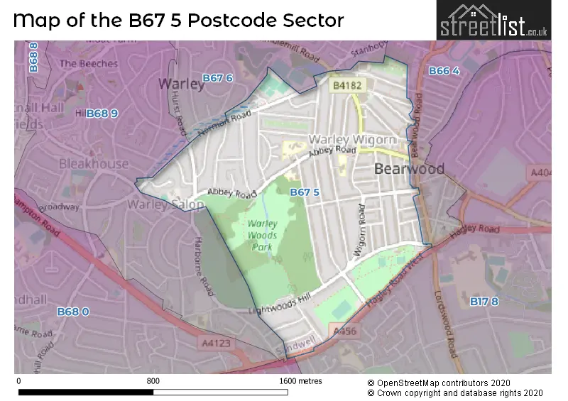
The B67 5 Postcode shares a border with B17 8 (BIRMINGHAM, Edgbaston, Harborne), B66 4 (SMETHWICK), B68 9 (OLDBURY), B32 2 (Quinton, BIRMINGHAM, Harborne) and B67 6 (SMETHWICK).
Map of the B67 5 Postcode Sector
Explore the B67 5 postcode sector by using our interactive map.
The sector is within the post town of SMETHWICK.
B67 5 is a postcode sector within the B67 postcode district which is within the B Birmingham postcode area.
The Royal Mail delivery office for the B67 5 postal sector is the Smethwick Delivery Office.
The area of the B67 5 postcode sector is 0.67 square miles which is 1.74 square kilometres or 429.34 square acres.
Waterways within the B67 5 postcode sector include the Thimblemill Brook.
Your support helps keep this site running!
If you enjoy using this website, consider buying me a coffee to help cover hosting costs.


| B | 6 | 7 | - | 5 | X | X |
| B | 6 | 7 | Space | 5 | Letter | Letter |
Official List of Streets
SMETHWICK (51 Streets)
Unofficial Streets or Alternative Spellings
SMETHWICK
BEARWOOD ROAD CARPAL WAYOLDBURY,
BROADMOOR AVENUEOLDBURY
HARBORNE ROADQuinton
HAGLEY ROAD WESTWeather Forecast for B67 5
Weather Forecast for Beech Lane
| Time Period | Icon | Description | Temperature | Rain Probability | Wind |
|---|---|---|---|---|---|
| 21:00 to 00:00 | Cloudy | 4.0°C (feels like 1.0°C) | 5.00% | SSW 9 mph |
| Time Period | Icon | Description | Temperature | Rain Probability | Wind |
|---|---|---|---|---|---|
| 00:00 to 03:00 | Overcast | 4.0°C (feels like 0.0°C) | 11.00% | SSW 9 mph | |
| 03:00 to 06:00 | Mist | 4.0°C (feels like 1.0°C) | 16.00% | SSW 9 mph | |
| 06:00 to 09:00 | Mist | 4.0°C (feels like 1.0°C) | 17.00% | SSW 9 mph | |
| 09:00 to 12:00 | Cloudy | 5.0°C (feels like 1.0°C) | 17.00% | SSW 9 mph | |
| 12:00 to 15:00 | Cloudy | 7.0°C (feels like 4.0°C) | 6.00% | SSW 11 mph | |
| 15:00 to 18:00 | Cloudy | 8.0°C (feels like 5.0°C) | 7.00% | SSW 11 mph | |
| 18:00 to 21:00 | Cloudy | 7.0°C (feels like 3.0°C) | 5.00% | SSW 11 mph | |
| 21:00 to 00:00 | Cloudy | 6.0°C (feels like 2.0°C) | 5.00% | SSW 13 mph |
| Time Period | Icon | Description | Temperature | Rain Probability | Wind |
|---|---|---|---|---|---|
| 00:00 to 03:00 | Cloudy | 5.0°C (feels like 1.0°C) | 6.00% | SSW 16 mph | |
| 03:00 to 06:00 | Cloudy | 6.0°C (feels like 1.0°C) | 6.00% | SSW 16 mph | |
| 06:00 to 09:00 | Cloudy | 6.0°C (feels like 2.0°C) | 5.00% | SSW 16 mph | |
| 09:00 to 12:00 | Overcast | 7.0°C (feels like 3.0°C) | 10.00% | SSW 18 mph | |
| 12:00 to 15:00 | Overcast | 9.0°C (feels like 5.0°C) | 23.00% | SSW 18 mph | |
| 15:00 to 18:00 | Heavy rain | 9.0°C (feels like 5.0°C) | 84.00% | SW 16 mph | |
| 18:00 to 21:00 | Heavy rain shower (night) | 7.0°C (feels like 4.0°C) | 55.00% | SW 11 mph | |
| 21:00 to 00:00 | Clear night | 6.0°C (feels like 2.0°C) | 5.00% | WSW 13 mph |
| Time Period | Icon | Description | Temperature | Rain Probability | Wind |
|---|---|---|---|---|---|
| 00:00 to 03:00 | Clear night | 4.0°C (feels like 1.0°C) | 1.00% | WSW 11 mph | |
| 03:00 to 06:00 | Clear night | 3.0°C (feels like -1.0°C) | 1.00% | WSW 11 mph | |
| 06:00 to 09:00 | Clear night | 2.0°C (feels like -1.0°C) | 1.00% | WSW 9 mph | |
| 09:00 to 12:00 | Cloudy | 3.0°C (feels like -1.0°C) | 4.00% | WSW 9 mph | |
| 12:00 to 15:00 | Cloudy | 6.0°C (feels like 3.0°C) | 4.00% | W 7 mph | |
| 15:00 to 18:00 | Cloudy | 7.0°C (feels like 5.0°C) | 4.00% | WNW 7 mph | |
| 18:00 to 21:00 | Clear night | 4.0°C (feels like 2.0°C) | 1.00% | WNW 4 mph | |
| 21:00 to 00:00 | Clear night | 2.0°C (feels like 0.0°C) | 1.00% | NW 4 mph |
| Time Period | Icon | Description | Temperature | Rain Probability | Wind |
|---|---|---|---|---|---|
| 00:00 to 03:00 | Clear night | 1.0°C (feels like -1.0°C) | 1.00% | NNW 4 mph | |
| 03:00 to 06:00 | Clear night | 0.0°C (feels like -2.0°C) | 2.00% | N 4 mph | |
| 06:00 to 09:00 | Clear night | 0.0°C (feels like -3.0°C) | 2.00% | NE 4 mph | |
| 09:00 to 12:00 | Sunny day | 1.0°C (feels like -2.0°C) | 2.00% | NNE 7 mph | |
| 12:00 to 15:00 | Sunny day | 5.0°C (feels like 2.0°C) | 1.00% | E 7 mph | |
| 15:00 to 18:00 | Sunny day | 6.0°C (feels like 4.0°C) | 1.00% | E 7 mph | |
| 18:00 to 21:00 | Clear night | 3.0°C (feels like 0.0°C) | 1.00% | ENE 9 mph | |
| 21:00 to 00:00 | Clear night | 2.0°C (feels like -2.0°C) | 0.00% | E 9 mph |
Schools and Places of Education Within the B67 5 Postcode Sector
Abbey Infant School
Community school
Maurice Road, Smethwick, West Midlands, B67 5LR
Head: Dr Richard Kentish
Ofsted Rating: Good
Inspection: 2023-03-14 (691 days ago)
Website: Visit Abbey Infant School Website
Phone: 01214291689
Number of Pupils: 290
Abbey Junior School
Community school
Barclay Road, Smethwick, West Midlands, B67 5LT
Head: Dr Richard Kentish
Ofsted Rating: Good
Inspection: 2019-12-12 (1879 days ago)
Website: Visit Abbey Junior School Website
Phone: 01214292700
Number of Pupils: 353
St Gregory's Catholic Primary School
Academy converter
Park Road, Smethwick, West Midlands, B67 5HX
Head: Mr Kevin Brown
Ofsted Rating: Outstanding
Inspection: 2019-03-06 (2160 days ago)
Website: Visit St Gregory's Catholic Primary School Website
Phone: 01214294609
Number of Pupils: 258
House Prices in the B67 5 Postcode Sector
| Type of Property | 2018 Average | 2018 Sales | 2017 Average | 2017 Sales | 2016 Average | 2016 Sales | 2015 Average | 2015 Sales |
|---|---|---|---|---|---|---|---|---|
| Detached | £320,417 | 6 | £357,500 | 2 | £320,325 | 6 | £259,590 | 5 |
| Semi-Detached | £207,416 | 32 | £205,491 | 48 | £206,687 | 40 | £181,009 | 27 |
| Terraced | £185,609 | 111 | £169,058 | 148 | £162,805 | 153 | £143,219 | 153 |
| Flats | £94,000 | 3 | £84,492 | 6 | £81,000 | 2 | £78,000 | 1 |
Important Postcodes B67 5 in the Postcode Sector
B67 5DP is the postcode for Lightwoods House, Adkins Lane, and Lightwoods House, 2 Adkins Lane
B67 5HX is the postcode for ST GREGORYS CATHOLIC PRIMARY SCHOOL, PARK ROAD, SMETHWICK, St Gregorys Catholic Primary School, Park Road, and St. Gregorys Catholic Primary School, Park Road
B67 5LR is the postcode for ABBEY INFANT SCHOOL, MAURICE ROAD, SMETHWICK, and Abbey Infant School, Maurice Road
B67 5LT is the postcode for KITCHEN & DINING BLOCK, Abbey Junior School, Abbey Road, Abbey Junior School, Abbey Road, and Abbey Junior School, Barclay Road
B67 5QT is the postcode for Smethwick Swimming Centre, Thimblemill Road
B67 5RJ is the postcode for Thimblemill Library, Thimblemill Road
| The B67 5 Sector is within these Local Authorities |
|
|---|---|
| The B67 5 Sector is within these Counties |
|
| The B67 5 Sector is within these Water Company Areas |
|