A wide range of spatial data has been analysed to present this overview of the B60 2 Postcode sector. If you would like anything added, please contact us.
The B60 2 postcode sector is within the county of Worcestershire.
Did you know? According to the 2021 Census, the B60 2 postcode sector is home to a bustling 7,795 residents!
Given that each sector allows for 400 unique postcode combinations. Letters C, I, K, M, O and V are not allowed in the last two letters of a postcode. With 197 postcodes already in use, this leaves 203 units available.
The B60 2 postal code covers the settlement of BROMSGROVE.
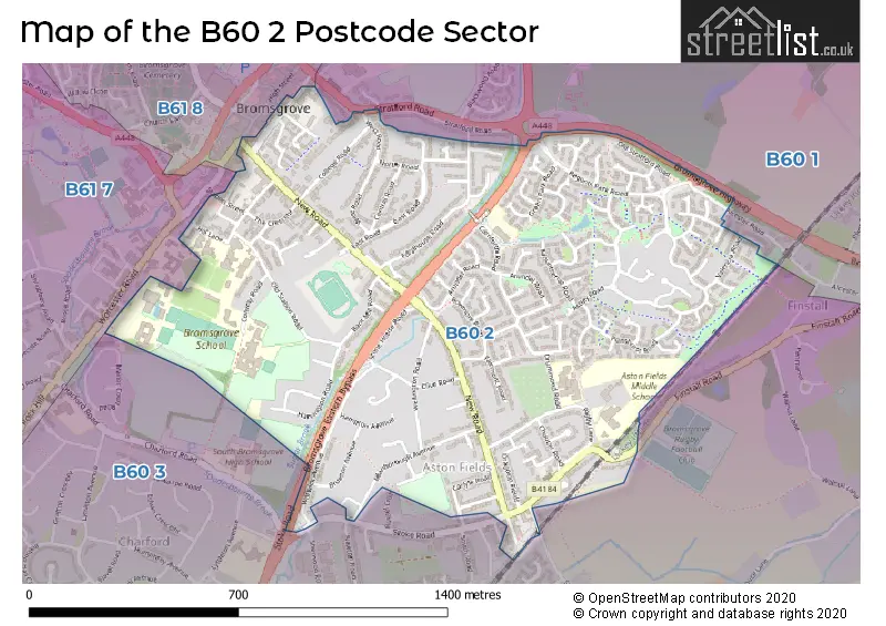
The B60 2 Postcode shares a border with B60 1 (Marlbrook, Lickey End, BROMSGROVE), B60 3 (BROMSGROVE, Stoke Heath, Finstall), B61 7 (BROMSGROVE, Upton Warren, Stoke Heath) and B61 8 (BROMSGROVE, Sidemoor).
Map of the B60 2 Postcode Sector
Explore the B60 2 postcode sector by using our interactive map.
The sector is within the post town of BROMSGROVE.
B60 2 is a postcode sector within the B60 postcode district which is within the B Birmingham postcode area.
The Royal Mail delivery office for the B60 2 postal sector is the Bromsgrove Delivery Office.
The area of the B60 2 postcode sector is 0.78 square miles which is 2.03 square kilometres or 502.09 square acres.
Your support helps keep this site running!
If you enjoy using this website, consider buying me a coffee to help cover hosting costs.


| B | 6 | 0 | - | 2 | X | X |
| B | 6 | 0 | Space | 2 | Letter | Letter |
Official List of Streets
BROMSGROVE (112 Streets)
Unofficial Streets or Alternative Spellings
Weather Forecast for B60 2
Weather Forecast for Bromsgrove
| Time Period | Icon | Description | Temperature | Rain Probability | Wind |
|---|---|---|---|---|---|
| 18:00 to 21:00 | Cloudy | 7.0°C (feels like 4.0°C) | 4.00% | SSW 9 mph | |
| 21:00 to 00:00 | Cloudy | 6.0°C (feels like 2.0°C) | 4.00% | S 9 mph |
| Time Period | Icon | Description | Temperature | Rain Probability | Wind |
|---|---|---|---|---|---|
| 00:00 to 03:00 | Cloudy | 6.0°C (feels like 2.0°C) | 5.00% | S 11 mph | |
| 03:00 to 06:00 | Cloudy | 6.0°C (feels like 2.0°C) | 5.00% | SSW 13 mph | |
| 06:00 to 09:00 | Cloudy | 7.0°C (feels like 3.0°C) | 5.00% | SSW 13 mph | |
| 09:00 to 12:00 | Overcast | 8.0°C (feels like 5.0°C) | 9.00% | SSW 16 mph | |
| 12:00 to 15:00 | Overcast | 10.0°C (feels like 7.0°C) | 22.00% | SSW 18 mph | |
| 15:00 to 18:00 | Heavy rain | 9.0°C (feels like 6.0°C) | 87.00% | SSW 16 mph | |
| 18:00 to 21:00 | Partly cloudy (night) | 8.0°C (feels like 5.0°C) | 31.00% | WSW 9 mph | |
| 21:00 to 00:00 | Clear night | 6.0°C (feels like 3.0°C) | 1.00% | SW 9 mph |
| Time Period | Icon | Description | Temperature | Rain Probability | Wind |
|---|---|---|---|---|---|
| 00:00 to 03:00 | Clear night | 4.0°C (feels like 2.0°C) | 0.00% | SW 7 mph | |
| 03:00 to 06:00 | Clear night | 3.0°C (feels like 0.0°C) | 1.00% | WSW 7 mph | |
| 06:00 to 09:00 | Clear night | 3.0°C (feels like 0.0°C) | 1.00% | WSW 7 mph | |
| 09:00 to 12:00 | Cloudy | 3.0°C (feels like 1.0°C) | 4.00% | WSW 4 mph | |
| 12:00 to 15:00 | Cloudy | 7.0°C (feels like 5.0°C) | 4.00% | W 4 mph | |
| 15:00 to 18:00 | Cloudy | 8.0°C (feels like 6.0°C) | 4.00% | NW 7 mph | |
| 18:00 to 21:00 | Partly cloudy (night) | 4.0°C (feels like 2.0°C) | 1.00% | NNW 4 mph | |
| 21:00 to 00:00 | Clear night | 2.0°C (feels like 1.0°C) | 0.00% | NNW 4 mph |
| Time Period | Icon | Description | Temperature | Rain Probability | Wind |
|---|---|---|---|---|---|
| 00:00 to 03:00 | Clear night | 1.0°C (feels like -1.0°C) | 0.00% | N 4 mph | |
| 03:00 to 06:00 | Clear night | 0.0°C (feels like -2.0°C) | 0.00% | NE 4 mph | |
| 06:00 to 09:00 | Clear night | 0.0°C (feels like -3.0°C) | 2.00% | ENE 4 mph | |
| 09:00 to 12:00 | Sunny day | 1.0°C (feels like -2.0°C) | 2.00% | ENE 4 mph | |
| 12:00 to 15:00 | Sunny day | 5.0°C (feels like 3.0°C) | 0.00% | ENE 7 mph | |
| 15:00 to 18:00 | Sunny day | 7.0°C (feels like 5.0°C) | 0.00% | E 7 mph | |
| 18:00 to 21:00 | Clear night | 4.0°C (feels like 1.0°C) | 1.00% | ENE 7 mph | |
| 21:00 to 00:00 | Clear night | 3.0°C (feels like 0.0°C) | 1.00% | ENE 7 mph |
| Time Period | Icon | Description | Temperature | Rain Probability | Wind |
|---|---|---|---|---|---|
| 00:00 to 03:00 | Clear night | 2.0°C (feels like -2.0°C) | 1.00% | ENE 7 mph | |
| 03:00 to 06:00 | Partly cloudy (night) | 1.0°C (feels like -2.0°C) | 3.00% | ENE 7 mph | |
| 06:00 to 09:00 | Overcast | 1.0°C (feels like -2.0°C) | 9.00% | ENE 7 mph | |
| 09:00 to 12:00 | Fog | 2.0°C (feels like -2.0°C) | 15.00% | ENE 9 mph | |
| 12:00 to 15:00 | Partly cloudy (day) | 4.0°C (feels like 1.0°C) | 3.00% | ENE 9 mph | |
| 15:00 to 18:00 | Sunny day | 5.0°C (feels like 2.0°C) | 2.00% | ENE 9 mph | |
| 18:00 to 21:00 | Clear night | 3.0°C (feels like 0.0°C) | 1.00% | NE 7 mph | |
| 21:00 to 00:00 | Clear night | 2.0°C (feels like -1.0°C) | 2.00% | ENE 7 mph |
Schools and Places of Education Within the B60 2 Postcode Sector
Aston Fields Middle School
Community school
Drummond Road, Bromsgrove, Worcestershire, B60 2ET
Head: Mrs Andrea Hales
Ofsted Rating: Outstanding
Inspection: 2014-06-26 (3875 days ago)
Website: Visit Aston Fields Middle School Website
Phone: 01527876026
Number of Pupils: 597
Finstall First School
Community school
Carnforth Road, Bromsgrove, Worcestershire, B60 2HS
Head: Mr Stuart Evans
Ofsted Rating: Outstanding
Inspection: 2015-04-22 (3575 days ago)
Website: Visit Finstall First School Website
Phone: 01527872938
Number of Pupils: 300
Rigby Hall Day Special School
Community special school
Rigby Lane, Bromsgrove, Worcestershire, B60 2EP
Head: Mrs Tracey Smith
Ofsted Rating: Requires improvement
Inspection: 2023-02-15 (719 days ago)
Website: Visit Rigby Hall Day Special School Website
Phone: 01527875475
Number of Pupils: 203
House Prices in the B60 2 Postcode Sector
| Type of Property | 2018 Average | 2018 Sales | 2017 Average | 2017 Sales | 2016 Average | 2016 Sales | 2015 Average | 2015 Sales |
|---|---|---|---|---|---|---|---|---|
| Detached | £415,798 | 64 | £361,236 | 59 | £357,914 | 71 | £322,591 | 68 |
| Semi-Detached | £262,472 | 58 | £256,980 | 49 | £269,742 | 39 | £232,332 | 38 |
| Terraced | £228,938 | 24 | £229,232 | 17 | £207,759 | 22 | £195,670 | 23 |
| Flats | £132,559 | 16 | £120,583 | 9 | £112,200 | 27 | £100,737 | 23 |
Important Postcodes B60 2 in the Postcode Sector
B60 2BJ is the postcode for Hereford & Worcester Fire & Rescue Service, Windsor Street
B60 2BL is the postcode for County Buildings, County Offices
B60 2BQ is the postcode for Connect Bromsgrove, Wendron Centre, 17 Chapel Street, and Wendron Centre, Chapel Street
B60 2DF is the postcode for Bromsgrove Police Station, The Crescent
B60 2EP is the postcode for Rigby Hall School, Rigby Lane
B60 2ET is the postcode for LIBRARY, Aston Fields Middle School, Drummond Road, GYM, Aston Fields Middle School, Drummond Road, and Aston Fields Middle School, Drummond Road
B60 2HS is the postcode for Finstal First School, Carnforth Road, and FINSTALL FIRST SCHOOL, CARNFORTH ROAD
B60 2JS is the postcode for Youthworks Ryland, New Road, and Doctors Surgery, 46 New Road
| The B60 2 Sector is within these Local Authorities |
|
|---|---|
| The B60 2 Sector is within these Counties |
|
| The B60 2 Sector is within these Water Company Areas |
|